TABLE OF CONTENTS

United States Fleet Anti-Submarine Instructions

Part V - AIRCRAFT


Page
5000 GENERAL 5-1
  5010 Mission 5-1
  5020 Degree of Coverage 5-1
  5030 Day and Night Coverage 5-1
  5040 Radar 5-1
  5050 Aerial Escort Plans 5-1
  5060 Stopping Pattern of Coverage 5-1
  5070 Sweeps Before Dark 5-1
  5080 HF/DF Sweeps 5-1
5100 AIRCRAFT CARRIER 5-2
  5110 Surface Escort 5-2
  5120 Station in Convoy 5-2
  5130 Station of Carrier Escorts 5-2
5200 ENROUTE TO ESCORT A CONVOY 5-2 -- 5-3
  5210 Attacks Enroute to Threatened Convoy 5-2
    5211 Convoy Not Threatened 5-2
  5220 Attacks While Escorting Threatened Convoy 5-2
  5230 Searches for Convoy 5-2
    5231 Variations in Convoy Positions 5-2
    5232 Not Met Reports 5-2
    5233 Homing to Threatened Convoy 5-2
    5234 Conduct During Search 5-2
  5240 Convoy Search Plans 5-3
    5241 Convoy Search Plan No. 1 5-3
    5242 Convoy Search Plan No. 2 5-3
    5243 Convoy Search Plan No. 3 5-3
5300 APPROACH, RECOGNITION AND RENDEZVOUS 5-4 -- 5-5
  5310 Limits of Approach to Allied Ships 5-4
    5311 Allied Merchant Ships Engaging Aircraft 5-4
  5320 Allied Merchant Ships Approach and Recognition 5-4
    5321 On Blinker 5-4
    5322 Flag Hoist 5-4
    5323 Aircraft Reply 5-4
  5330 Neutral Ships Approach and Recognition 5-4
    5331 Use of "Sugar Charlie" 5-4
  5340 Recognition and Rendezvous with Convoy 5-4
    5341 Arrival at Convoy 5-4
    5342 Designation of Escort Commander's Ship 5-4
    5343 MET Reports 5-5
    5344 Sending Positions 5-5
    5345 Obtaining Convoy Position 5-5
    5346 Use of Blinker 5-5
5400 AERIAL ESCORT PLANS 5-5 -- 5-20
  5410 Selection of Plan 5-5
    5411 Example 5-5
  5420 Determining Effective Visibility 5-5
  5430 Use of Radar 5-5
  5440 Flying the Plan 5-5
  5450 Aerial Escort Plans 5-6
    5451 Aerial Escort Plan ABLE 5-6
    5452 Aerial Escort Plan BAKER 5-7
    5453 Aerial Escort Plan CHARLIE 5-8
    5454 Aerial Escort Plan DOG 5-9
    5455 Aerial Escort Plan EASY 5-10
    5456 Aerial Escort Plan FOX 5-11
    5457 Aerial Escort Plan GEORGE 5-12
  5460 Small Single Engine Aircraft 5-13
    5461 Aerial Escort Plan HOW 5-14

[5-i]

Table of Contents - Part V (Continued)


Page
    5462 Aerial Escort Plan ITEM 5-15
  5470 Plans, JIG, KING and LOVE Explained 5-16
    5471 Use with Large Task Forces 5-16
    5472 Plan LOVE with Large Slow Task Forces 5-16
    5473 Additional Pre-Dark Flights 5-16
    5474 Use of A/C with Different Speed 5-16
    5475 Aerial Escort Plan JIG 5-17
    5476 Aerial Escort Plan KING 5-18
    5477 Aerial Escort Plan LOVE 5-19
  5480 British Convoy Patrols and Searches 5-20
    5481 COBRA 5-20
    5482 CROCODILE 5-20
    5483 VIPER 5-20
    5484 ADDER 5-20
    5485 ALLIGATOR 5-20
    5486 FROG 5-20
    5487 PYTHON 5-20
    5488 MAMBA 5-20
    5489 LIZARD 5-20
    54810 REPTILE 5-20
5500 SAFETY OF CONVOY AFTER SUBMARINE SIGHTING OR ATTACK 5-21
  5510 Relief Aircraft 5-21
  5520 Warning to Convoy 5-21
  5530 Warning to Merchant Ship 5-21
  5540 Hold-Down Tactics 5-21
    5541 Hold-Down Astern 5-21
    5542 Use of Radar 5-21
  5550 Position Fix by Radar 5-21
5600 DEPARTURE FROM CONVOY 5-21
  5610 Notification of departure 5-21
  5620 Convoy Position Report 5-21
  5630 Night Relief 5-21
  5640 Night Departure 5-21
  5650 Night Patrol Altitudes and Sectors 5-21
5700 EMERGENCIES AND FORCED LANDINGS 5-22
  5710 Warning to Surface Craft 5-22
  5720 Forced Landings 5-22
5800 ENEMY AND OPPOSITION 5-22
  5810 Fighter Protection 5-22
  5820 Operational Control 5-22
  5830 Fighter Director Procedures 5-22
    5831 Patrol Areas 5-22
    5832 Recognition Procedure 5-22
    5833 Identification of Aircraft 5-22
5900 AIRSHIPS 5-23
  5910 Operational Use 5-23
  5920 Escort Patrols 5-23
  5930 Limits of Escort Patrols 5-23
  5940 One Airship Escort Patrol 5-23
  5950 Two Airships Escort Patrol 5-23
  5960 Three Airships Escort Patrol 5-23
  5970 Altitude Limitations 5-23

[5-ii]

United States Fleet Anti-Submarine Instructions

Part V

AIRCRAFT


5000 GENERAL.

  1. The mission of air escorts is to protect or to assist in the protection of ships against enemy action. Unless specifically stated otherwise, air escorts will comply with the operational instructions of the Surface Escort Commander insofar as safety of the aircraft will permit.

  1. The degree of threat as established by the Commander in Chief, United States Fleet or local submarine estimates ifs the guiding consideration in the tactical employment of air escorts. Aerial coverage shall vary from maximum practicable when the presence of a submarine is established to limited coverage when no submarine is estimated to be present.

  1. Weather permitting, day escorts are maintained from one hour before daylight to one hour after dark, and night escorts from one hour before dark until one hour after daylight unless other times are specifically stated in the orders.

  1. Aircraft radar shall be used at al times in aerial escort of convoy operations unless specifically directed otherwise. Consider all "disappearing blips" as bona fide contacts and so report.

  1. Aerial Escort Plans are described in Article 5400. In view of the fact that these plans were evolved after extensive study, it is neither necessary nor desirable that the prescribed areas or tracks be altered or further subdivided or that additional planes be assigned, unless a concentration of submarines or other tactical considerations so require. Properly executed, the plans provided therein will enable a minimum number of planes to prevent a surfaced submarine from shadowing or getting within torpedo range of the escorted ship or convoy.

  1. If a single plane, in order to conduct hold-down or gambit tactics, stops the pattern of its coverage without being relieved, there is a possibility that other submarines may reach attacking positions without being discovered. The decision, therefore, whether or not to use hold-down or gambit tactics should be referred to the Escort Commander if applicable.

  1. Sweeps before dark to twice visibility distance abeam and astern of the convoy are important in that they may uncover submarines "moving up". This is particularly true if the convoy has been smoking or leaving a trail. In the absence of night coverage, if aircraft are available, sweeps ahead should be conducted to cover night advance.

  1. Exploratory sweeps based upon HF/DF evidence will be flown at the direction of the Escort Commander.

[5-1]

5100 AIRCRAFT CARRIER.

  1. Aircraft carriers employed in aerial escort operations shall be provided with an adequate surface screen. When a carrier has her own screening group, normally she and her screening group shall have complete freedom of movement in order to operate her planes as may be required.

  1. Each aircraft carrier placed in the convoy formation shall be assigned the entire column astern of the column leader in a column adjacent to the Commodore's.

  1. When a carrier occupies a position in a convoy and her surface screen is temporarily assigned to the convoy screen, it should be stationed in positions from which they can be withdrawn expeditiously in the event that the carrier desires to depart from the convoy. Normally it should not take part in organized hunts or searches that will take them away from the convoy.


5200 ENROUTE TO ESCORT A CONVOY.

  1. When a submarine is sighted by an aircraft enroute to escort a threatened convoy, an attack shall be delivered only if a Class A target is presented. Aircraft carrying two depth bombs shall drop two. All others shall expend not more than one-half of the bomb load, and in any case a maximum of four.
    1. If the convoy is not threatened, normal attack procedures shall be carried out. Unless specifically directed otherwise an aircraft shall not remain in the vicinity of a sighting or attack for longer than 30 minutes before proceeding on the mission assigned.

  1. When an aircraft is escorting a threatened convoy, i.e., when a concentration of submarines is known to exist in the area, a special situation is created. Under these circumstances the bomb load shall not be expended unless a Class A attack is possible. The possibility of more than one sighting must be considered, and unless the limit of the endurance of the aircraft is being reached, the maximum effect of the bomb load shall be the first consideration.

  1. Searches for Convoys.
    1. The position of a convoy may vary from its estimated position over a period of time due to inaccurate estimates of wind, sea, current and changes of course and speed. Greater variations may be expected from change of speed than from change of course. Unless the exact position of the convoy is known at the time of aircraft's departure from base, the applicable Convoy Search Plan, Article 5240, shall be employed.
    2. If the convoy has not been found upon the completion of the first circuit of the search plan, the aircraft shall transmit an encrypted "NOT MET" report to the base.
    3. In the event the convoy is threatened, a request for homing may be transmitted one hour prior to the estimated time of arrival at the convoy, if such has been ordered by air control. The decision as to the feasibility of transmitting homing signals rests with the Escort Commander.
    4. Pilots are cautioned to conduct their search so that time permits their return to the base or carrier as scheduled. Should carrier aircraft, during this search (without having sighted convoy), come in sight of the carrier within two hours, use message drop to indicate time on search and area searched so that the Commanding Officer may then decide whether to continue with present search plan or to recover and launch a new group. Aircraft will circle and await instruction.

[5-2]

  1. The Convoy Search Plans.
    1. CONVOY SEARCH PLAN No.1 - Convoy's position, course and speed reported.

      (For convoy approaching the aircraft's base.)

      Search Plan No. 1

      Start the search from Point A, which is 15 + t miles ahead of the estimated convoy position at the time of commencing the search (t is the number of hours since the last position report of the convoy). From Point A fly along the convoy track through the estimated convoy position to Point B which is 30 + 2t miles astern. Then turn at right angles to the convoy track and fly to Point C, which is ten (10) miles from point B for visual search of fifteen (15) miles for radar search. Then fly parallel to the convoy track to Point D which is 15 + t miles ahead of the estimated convoy position (at the time D is reached). Then turn at right angles and fly across the convoy track to Point E which is 20 miles from D for visual, or 30 miles for radar search. Then fly parallel to the convoy track to Point F, which is 30 + 2t miles astern of the estimated convoy position (at the time Point F is reached).

    2.  

    3. CONVOY SEARCH PLAN No.2 - Convoy's position, course and speed reported.

      (For convoy moving away from the aircraft's base.)

      Search Plan No. 2

      Start the search from point A, which is 30 + 2t miles astern of the estimated convoy position at the time of commencing the search (t is the number of hours since the last position report of the convoy).

      From Point A fly along the convoy track through the estimated convoy position to Point B which is 15 + t miles ahead. Then turn at right angles to the convoy track and fly to Point C. Then fly parallel to the convoy track to Point D which is 30 + 2t miles astern of the estimated convoy position (at the time D is reached). Then turn at right angles and fly across the convoy track to Point E. Then fly parallel to the convoy track to Point F, which is 15 + t miles ahead of the estimated convoy position (at the time Point F is reached). The distances B to C and D to E in Search Plans 1 and 2 are designed for normal conditions. The size of the convoy and other factors affecting the aircraft's momentary detective range must be considered in determining the distances used. If the convoy is not met when reaching the end of plan, and further search is intended, revise estimate of convoy position and repeat search, or repeat search using double the initial values of BC and DE.

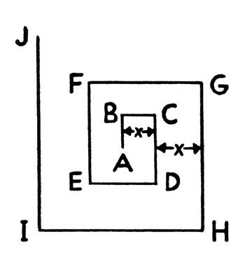
    4. CONVOY SEARCH PLAN No.3 - When convoy's position only is given.

      Search Plan No. 3

      Start the search from point A, the reported position of the convoy, then proceed to Points B, C, D, etc., respectively. The distances between parallel tracks (X) normally should be one and a half times the aircraft's visual or radar detective range.

      If the convoy is not met at the end of two hours search, a report should be made to base. In the absence of further instructions, the expanding search should be continued.

[5-3]

5300 APPROACH, RECOGNITION AND RENDEZVOUS.

  1. The limits of approach to allied ships are described in S.P. 02312(4) - AIR/SEA RECOGNITION. Aircraft shall never approach surface ships in a manner that might be construed as threatening. Circling approaches shall be made in order to present silhouette views to the surface observers for visual identification.
    1. Allied merchant ships are free to engage any aircraft not recognized as friendly which approach within 1500 yards except within the following areas:
      1. In the Pacific:
        1. Within 200 miles of the North American continent, or
        2. Within an arc of 1200-mile radius from Balboa.

      2. In the Indian Ocean:
      3. When Westward of 80° East and within 500 miles of British or British occupied territory.

        NOTE: In the above areas merchant ships have been directed not to open fire on aircraft unless actually attacked.

  1. Allied merchant ships shall be approached and recognition signals exchanged in accordance with the applicable "Key Memoranda". When challenged by the designated aircraft challenge (currently group "OE" from the Recognition Manual, S.P. 02220(3) ). the ship may be expected to display her reply to such challenge by either of the following methods:
    1. Flashing on blinker her International Call Signal letters followed by her Identification Signal.
    2. Hoisting her International Call Signal Letters and her Identification Signal.
    3. Either of the above replies then requires a single letter answer from the aircraft (also from "Key Memoranda") to identify itself as friendly.

  1. Neutral ships, currently designated in R.P.S. 9 Series as non-belligerent ships operating in their own interests, do not have access to classified publications for necessary identification procedures. Escort aircraft shall be informed of the known movement of such ships in each case.
    1. If a neutral merchant ship is met the following procedure shall be carried out:
      1. The aircraft shall transmit by Visual the International Signal "SUGAR CHARLIE". The ship should reply by hoisting her international call sign.
      2. A report of the ship's movement, including her call sign if given, shall be transmitted to base, and unless specific instructions are issued, the aircraft shall continue on its assigned mission.

  1. Recognition and rendezvous with the convoy shall be effected as follows:
    1. Upon arrival at the convoy, aircraft shall approach the Escort Commander's ship, exchange recognition signals at 3000 yards and state, by visual signal, the type and duration of patrol, the aircraft's call and then request any special instructions.
    2. The Escort Commander's ship is designated by the International "YOKE" flag flown at the foretruck during daylight hours. In addition, during daylight the Escort Commander shall, upon sighting the aircraft and recognizing it as friendly, keep a steady searchlight directed at the aircraft until it approaches position for exchange of recognition signals.

[5-4]

    1. "MET" reports shall be sent under the following conditions:
      1. When the convoy's position is at a distance greater than the aircraft's detective range from the estimated track.
      2. When a "NOT MET" report has been sent previously.
      3. When homing procedure has been used.
      4. When carrier-based aircraft are so ordered by the Carrier Commander.

    2. If radio silence is in effect, the aircraft shall make a search around the convoy once in accordance with the Aerial Escort Plan being used, then proceed to a point at least fifty (50) miles from the convoy before sending the report. The convoy's position shall always be included in "MET" reports.
    3. The procedure for obtaining the convoy's position is as follows:
      1. The aircraft shall request position report from the Escort Commander by visual transmission using the International Code Signal, "LOVE FOX XRAY" (What is your present position?)
      2. The Escort Commander shall indicate his position by hoisting International Code Signal Flags for (1) latitude; (2) longitude. This position as indicated by the flags will be the position of the Escort Commander at the time the first hoist is made. These flag hoists shall be made separately and consecutively and kept flying until the escort plane acknowledges receipt.

    4. When the use of flags, as above, is impracticable, the Escort Commander may use blinker. Only that portion of the foregoing procedure that can be accomplished without the use of visual signals is applicable at night.


5400 AERIAL ESCORT PLANS.

  1. Plans ABLE to GEORGE are for escort of merchant convoys by medium or long-range aircraft. Plans HOW and ITEM are for small single engine aircraft operating from shore bases. Plans JIG, KING, and LOVE are for escort of small task forces and fast convoys (speed of advance 12 knots or over). In selecting a plan for escort of merchant convoys the pilot must first determine the value of the ratio of the airspeed of his aircraft to the speed of the convoy. This ratio determines which of the Plans ABLE, BAKER, and CHARLIE is appropriate, or it determines the lengths of certain search legs if any other plan is used. If this ratio is between 8 and 12, Plan ABLE is appropriate; if the ratio is between 12 and 16, Plan BAKER is appropriate; and if the ratio is greater than 16, then Plan CHARLIE is appropriate. For example:
    1. If a 120 knot (airspeed) aircraft is assigned to protect a convoy of 8 knots speed, then the ratio is 120/8, or 15. Accordingly, Plan BAKER would be used. If, however, during a given assignment, the convoy should change speed radically, the Escort Plan should be changed also, provided the new ratio calls for a different plan.

  1. The appropriate plan for escort of the convoy having been selected, the Effective Visibility should be determined. For planes using radar, obtain the Effective Visibility for a surfaced submarine from Table 1 (Article 2231). For planes using visual search, obtain the Effective Visibility for a surfaced submarine from Table 2 (Article 2261). If the value of Effective Visibility obtained is smaller than 3, use 3; if larger than 10, use 10. This Effective Visibility, denoted E in the diagrams, is the factor which determines the lengths of the various legs of the escorting aircraft's plan.

  1. Aircraft shall use radar at all times when flying the aerial escort plans.

  1. After flying the right hand section of the patrol, the aircraft, except when using Plan HOW, ITEM, or GEORGE, then flies the exact left hand section on the left side of the convoy, and continues alternating, as indicated in the diagram. At the beginning of each section of the patrol, right or left, the aircraft starts from position A, a definite distance to the right (or left as the case may be) of the leading outboard ship of the convoy. The accurate determination of this distance and position is almost as important as the determination of the other distances involved, from the standpoint of adequate coverage and closure of the course.

[5-5]

  1. Aerial Escort Plans.
    1.  

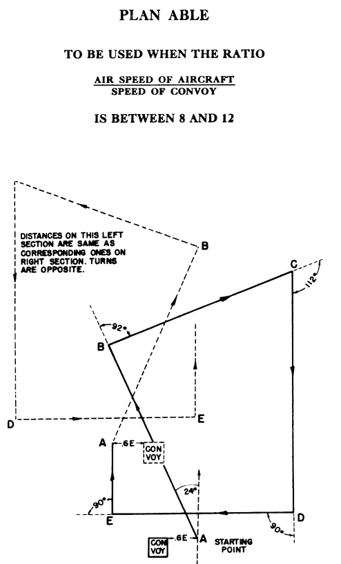
AERIAL ESCORT PLAN ABLE

LENGTHS OF LEGS IN NAUTICAL MILES

E (miles) = 3 4 5 6 7 8 9 10
(And Over)
Start Point 1.8 2.4 3.0 3.6 4.2 4.8 5.4 6.0
First Course 24° L 24° L 24° L 24° L 24° L 24° L 24° L 24° L
AB 12.6 16.8 21.0 35.2 39.4 33.6 37.8 42.0
Change Course 92° R 92° R 92° R 92° R 92° R 92° R 92° R 92° R
BC 11.4 15.2 19.0 22.8 26.6 30.4 34.2 38.0
Change Course 112° R 112° R 112° R 112° R 112° R 112° R 112° R 112° R
CD 15.0 20.0 25.0 30.0 35.0 40.0 45.0 50.0
Change Course 90° R 90° R 90° R 90° R 90° R 90° R 90° R 90° R
DE 10.8 14.4 18.0 21.6 25.2 28.8 32.4 36.0
Change Course 90° R 90° R 90° R 90° R 90° R 90° R 90° R 90° R
EA (approx.) 4.2 5.6 7.0 5.4 9.8 11.2 12.6 14.0
NOTES: Above table is for RIGHT HAND circuit. For LEFT HAND circuit, make first course and subsequent changes in directions opposite those given in table.

E (Effective Visibility) is obtained for radar search from Table 1 (Article 2231) and for visual search from Table 2 (Article 2261). Use values for a surfaced submarine.

Plan ABLE

[5-6]

    1.  

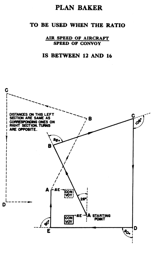
AERIAL ESCORT PLAN BAKER

LENGTHS OF LEGS IN NAUTICAL MILES

E (miles) = 3 4 5 6 7 8 9 10
(And Over)
Start Point 1.8 2.4 3.0 3.6 4.2 4.8 5.4 6.0
First Course 26° L 26° L 26° L 26° L 26° L 26° L 26° L 26° L
AB 10.8 14.4 18.0 21.6 25.2 28.8 32.4 36.0
Change Course 98° R 98° R 98° R 98° R 98° R 98° R 98° R 98° R
BC 11.4 15.2 19.0 22.8 26.6 30.4 34.2 38.0
Change Course 108° R 108° R 108° R 108° R 108° R 108° R 108° R 108° R
CD 15.0 20.0 25.0 30.0 35.0 40.0 45.0 50.0
Change Course 90° R 90° R 90° R 90° R 90° R 90° R 90° R 90° R
DE 10.8 14.4 18.0 21.6 25.2 28.8 32.4 36.0
Change Course 90° R 90° R 90° R 90° R 90° R 90° R 90° R 90° R
EA (approx.) 5.4 7.2 9.0 10.8 12.6 14.4 16.2 18.0
NOTES: Above table is for RIGHT HAND circuit. For LEFT HAND circuit, make first course and subsequent changes in directions opposite those given in table.

E (Effective Visibility) is obtained for radar search from Table 1 (Article 2231) and for visual search from Table 2 (Article 2261). Use values for a surfaced submarine.

Plan BAKER

[5-7]

    1.  

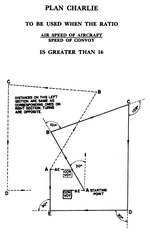
AERIAL ESCORT PLAN CHARLIE

LENGTHS OF LEGS IN NAUTICAL MILES

E (miles) = 3 4 5 6 7 8 9 10
(And Over)
Start Point 1.8 2.4 3.0 3.6 4.2 4.8 5.4 6.0
First Course 30° L 30° L 30° L 30° L 30° L 30° L 30° L 30° L
AB 9.6 12.8 16.0 19.2 22.4 25.6 28.8 32.0
Change Course 101° R 101° R 101° R 101° R 101° R 101° R 101° R 101° R
BC 11.4 15.2 19.0 22.8 26.6 30.4 34.2 38.0
Change Course 109° R 109° R 109° R 109° R 109° R 109° R 109° R 109° R
CD 15.0 20.0 25.0 30.0 35.0 40.0 45.0 50.0
Change Course 90° R 90° R 90° R 90° R 90° R 90° R 90° R 90° R
DE 10.8 14.4 18.0 21.6 25.2 28.8 32.4 36.0
Change Course 90° R 90° R 90° R 90° R 90° R 90° R 90° R 90° R
EA (approx.) 6.0 8.0 10.0 12.0 14.0 16.0 18.0 20.0
NOTES: Above table is for RIGHT HAND circuit. For LEFT HAND circuit, make first course and subsequent changes in directions opposite those given in table.

E (Effective Visibility) is obtained for radar search from Table 1 (Article 2231) and for visual search from Table 2 (Article 2261). Use values for a surfaced submarine.

Plan CHARLIE

[5-8]

    1.  

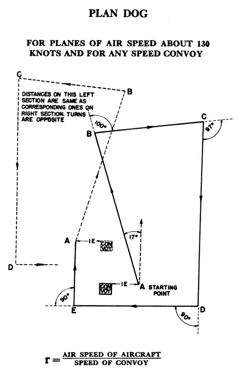
AERIAL ESCORT PLAN DOG

Aircraft/Convoy Speed Ratio r1=20, r2=16, r3=12, r4=8

LENGTHS OF LEGS IN NAUTICAL MILES

E (miles) = 3 4 5 6 7 8 9 10
(And Over)
Start Point 3.0 4.0 5.0 6.0 7.0 8.0 9.0 10.0
First Course 17° L 17° L 17° L 17° L 17° L 17° L 17° L 17° L
AB 18.0 24.0 30.0 36.0 42.0 48.0 54.0 60.0
Change Course 100° R 100° R 100° R 100° R 100° R 100° R 100° R 100° R
BC 12.0 16.0 20.0 24.0 28.0 32.0 36.0 40.0
Change Course 97° R 97° R 97° R 97° R 97° R 97° R 97° R 97° R
CD r1 23.8 31.8 39.7 47.7 55.6 63.6 71.5 79.4
CD r2 22.4 29.8 37.3 44.8 52.2 59.7 67.1 74.6
CD r3 20.0 26.7 33.4 40.1 46.8 53.5 60.1 66.8
CD r4 15.7 20.9 26.1 31.3 36.6 41.8 46.8 52.0
Change Course 90° R 90° R 90° R 90° R 90° R 90° R 90° R 90° R
DE 13.8 18.4 23.0 27.6 32.2 36.8 41.4 46.0
Change Course 90° R 90° R 90° R 90° R 90° R 90° R 90° R 90° R
EA r1 8.4 11.2 14.0 16.8 19.6 22.4 25.2 28.0
EA r2 7.8 10.4 13.0 15.6 18.2 20.8 23.4 26.0
EA r3 6.8 9.0 11.3 13.6 15.8 18.1 20.4 22.7
EA r4 4.8 6.4 8.0 9.6 11.2 12.8 14.4 16.0
NOTES: Above table is for RIGHT HAND circuit. For LEFT HAND circuit, make first course and subsequent changes in directions opposite those given in table.

E (Effective Visibility) is obtained for radar search from Table 1 (Article 2231) and for visual search from Table 2 (Article 2261). Use values for surfaced submarine.

Plan DOG

[5-9]

    1.  

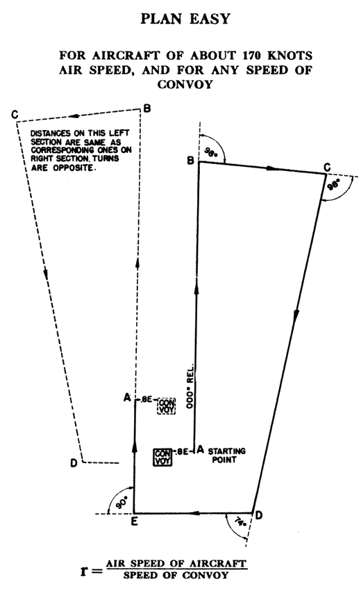
AERIAL ESCORT PLAN EASY

Aircraft/Convoy Speed Ratio r1=25, r2=20, r3=15, r4=10

LENGTHS OF LEGS IN NAUTICAL MILES

E (miles) = 3 4 5 6 7
(And Over)
Start Point 2.4 3.2 4.0 4.8 5.6
First Course
AB r1 20.5 27.4 34.2 41.1 47.9
AB r2 22.2 29.6 37.0 44.4 51.8
AB r3 25.0 33.4 41.7 50.1 58.4
AB r4 30.6 40.8 51.0 61.2 71.4
Change Course 98° R 98° R 98° R 98° R 98° R
BC 12.0 16.0 20.0 24.0 28.0
Change Course 98° R 98° R 98° R 98° R 98° R
CD 27.0 36.0 45.0 54.0 63.0
Change Course 74° R 74° R 74° R 74° R 74° R
DE 10.8 14.4 18.0 21.6 25.2
Change Course 90° R 90° R 90° R 90° R 90° R
EA r1 10.3 13.8 17.4 20.9 24.4
EA r2 9.6 12.8 16.0 19.2 22.4
EA r3 8.2 11.0 13.7 16.5 19.2
EA r4 5.4 7.2 9.0 10.8 12.6
NOTES: Above table is for RIGHT HAND circuit. For LEFT HAND circuit, make first course and subsequent changes in directions opposite those given in table.

E (Effective Visibility) is obtained for radar search from Table 1 (Article 2231) and for visual search from Table 2 (Article 2261). Use values for surfaced submarine.

Plan EASY

[5-10]

    1.  

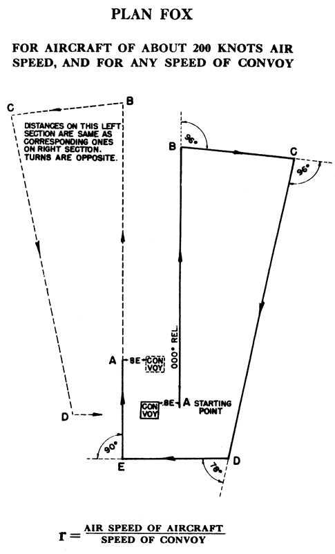
AERIAL ESCORT PLAN FOX

Aircraft/Convoy Speed Ratio r1=30, r2=25, r3=20, r4=15

LENGTHS OF LEGS IN NAUTICAL MILES

E (miles) = 3 4 5 6 7
(And Over)
Start Point 2.4 3.2 4.0 4.8 5.6
First Course
AB r1 24.4 32.6 40.7 48.9 57.1
AB r2 25.7 34.3 42.8 51.4 60.0
AB r3 27.6 36.8 46.0 52.2 64.4
AB r4 30.8 40.1 51.4 61.7 72.0
Change Course 96° R 96° R 96° R 96° R 96° R
BC 12.0 16.0 20.0 24.0 28.0
Change Course 96° R 96° R 96° R 96° R 96° R
CD 33.0 44.0 55.0 66.0 77.0
Change Course 78° R 78° R 78° R 78° R 78° R
DE 11.4 15.2 19.0 22.8 26.6
Change Course 90° R 90° R 90° R 90° R 90° R
EA r1 12.4 16.6 20.7 24.9 29.0
EA r2 11.8 15.7 19.6 23.5 27.5
EA r3 10.8 14.4 18.0 21.6 25.2
EA r4 9.2 12.3 15.3 18.4 21.4
NOTES: Above table is for RIGHT HAND circuit. For LEFT HAND circuit, make first course and subsequent changes in directions opposite those given in table.

E (Effective Visibility) is obtained for radar search from Table 1 (Article 2231) and for visual search from Table 2 (Article 2261). Use values for surfaced submarine.

Plan FOX

[5-11]

    1.  

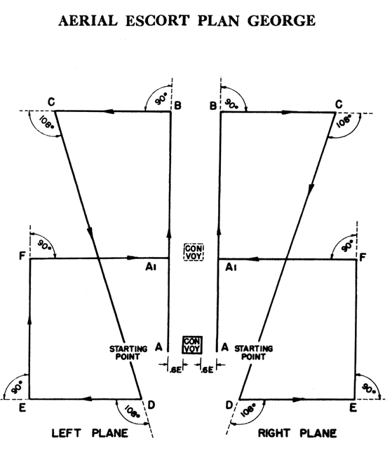
AERIAL ESCORT PLAN GEORGE

FOR TWO PLANES OF EQUAL SPEED (115 TO 170 KNOTS)

Aircraft/Convoy Speed Ratio r1=25, r2=20, r3=15, r4=10

LENGTHS OF LEGS IN NAUTICAL MILES

E (miles) = 3 4 5 6
(And Over)
Start Point 1.8 2.4 3.0 3.6
First Course
AB r1 19.5 25.9 32.4 38.9
AB r2 20.6 27.4 34.3 41.2
AB r3 22.4 29.9 37.3 44.8
AB r4 26.1 34.8 43.5 52.2
Change Course 90° R 90° R 90° R 90° R
BC 12.0 16.0 20.0 24.0
Change Course 108° R 108° R 108° R 108° R
CD 31.8 42.4 53.0 63.6
Change Course 108° L 108° L 108° L 108° L
DE 12.0 16.0 20.0 24.0
Change Course 90° L 90° L 90° L 90° L
EF 15.0 20.0 25.0 30.0
Change Course 90° L 90° L 90° L 90° L
FA 14.4 19.2 24.0 28.8
NOTES: Above table is for RIGHT HAND circuit. For LEFT HAND circuit, make first course and subsequent changes in directions opposite those given in table.

E (Effective Visibility) is obtained for radar search from Table 1 (Article 2231) and for visual search from Table 2 (Article 2261). Use value for surfaced submarine.

Plan GEORGE

[5-12]

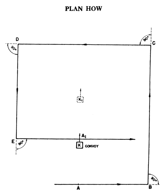
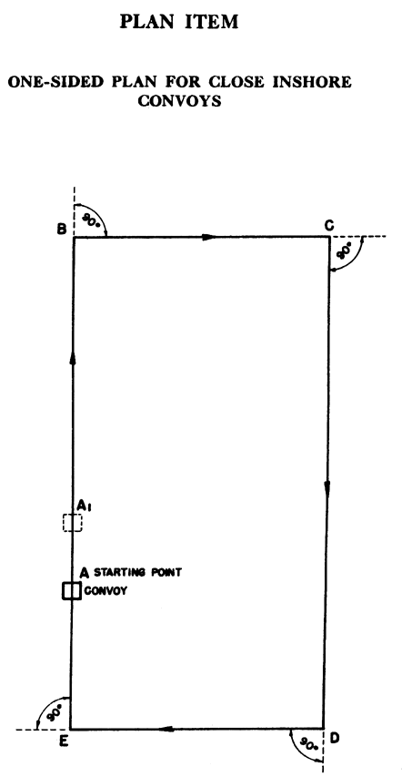
  1. The following escort plans have been developed for the use of small single engine aircraft to eliminate much of the navigation required in plans ABLE, BAKER and CHARLIE. These plans are not generally suitable for convoys which are very far from the coast or for larger planes which carry a navigator, for the reason that the plans do not cover a sufficiently large area to prevent shadowing tactics and the gathering of wolf packs. Two plans have been developed, the second of which is designed for convoys quite close inshore. Specifically:

    CASE (I) - If the convoy is further distant that 3E from the 5 fathom line, then Plan HOW is used as given.

    CASE (II) - if the convoy is within 3E of the five fathom line then Plan ITEM is used.

    Both of these Plans, (HOW and ITEM) have been computed carefully to give the maximum safe area of coverage. Accordingly, the lengths of the various legs of the course should not be exceeded, if safe coverage is to be maintained.

[5-13]

    1.  

AERIAL ESCORT PLAN HOW

SMALL SINGLE ENGINE AIRCRAFT

Tables are for Convoy Speeds of 6 and 10 knots.
Interpolate as Necessary for Other Convoy Speeds.
Values in Tables Expressed in Nautical Miles.

 :

CONVOY SPEED 6 KNOTS
E (miles) = 3 4 5 6 7 8 9 10
(And Over)
Start Astern 2.9 3.8 4.8 5.7 6.7 7.6 8.6 9.5
AB 6.1 8.2 10.2 12.3 14.3 16.4 18.4 20.5
BC 13.9 18.6 23.2 27.8 32.5 37.1 41.7 46.4
CD 12.2 16.4 20.4 24.6 28.6 32.8 36.8 40.9
DE 10.6 14.2 17.7 21.3 24.8 28.4 31.9 35.5
EA1 6.1 8.2 10.2 12.3 14.3 16.4 18.4 20.5


CONVOY SPEED 10 KNOTS
Start Astern 0.6 0.8 1.0 1.2 1.4 1.6 1.7 1.9
AB 5.2 6.9 8.7 10.4 12.1 13.9 15.6 17.3
BC 12.7 16.9 21.2 25.4 29.6 33.9 38.1 42.3
CD 10.4 13.9 17.4 20.8 24.2 27.8 31.2 34.6
DE 8.1 10.8 13.5 16.2 18.9 21.6 24.2 26.9
EA1 5.2 6.9 8.7 10.4 12.1 13.9 15.6 17.3
NOTES:

E (Effective Visibility) is obtained for radar search from Table 1 (Article 2231) and for visual search from Table 2 (Article 2261). Use values for surfaced submarine.

Plan HOW

[5-14]

    1.  

AERIAL ESCORT PLAN ITEM

SMALL SINGLE ENGINE AIRCRAFT

Tables are for Convoy Speeds of 6, 10 and 14 knots.
Interpolate as Necessary for Other Convoy Speeds.

 :

CONVOY SPEED 6 KNOTS
E (miles) = 3 4 5 6 7 8 9 10
(And Over)
AB 12.0 16.0 20.0 24.0 28.0 32.0 36.0 40.0
BC 8.2 10.9 13.6 16.4 19.1 21.8 24.5 27.3
CD 14.2 18.9 23.6 28.4 33.1 37.8 42.5 47.3
DE 8.2 10.9 13.6 16.4 19.1 21.8 24.5 27.3
EA1 5.5 7.3 9.1 10.9 12.7 14.6 16.4 18.2


CONVOY SPEED 10 KNOTS
AB 12.3 16.4 20.5 24.6 28.7 32.8 36.9 41.0
BC 6.9 9.2 11.5 13.9 16.2 18.5 20.8 23.1
CD 10.8 14.4 18.0 21.6 25.2 28.8 32.3 35.9
DE 6.9 9.2 11.5 13.9 16.2 18.5 20.8 23.1
EA1 3.1 4.1 5.1 6.2 7.2 8.2 9.2 10.3


CONVOY SPEED 14 KNOTS
AB 12.5 16.7 20.9 25.1 29.2 33.4 37.6 41.8
BC 6.0 8.0 10.0 12.0 14.0 16.0 18.0 20.0
CD 8.3 11.0 13.8 16.5 19.3 22.1 24.8 27.6
DE 6.0 8.0 10.0 12.0 14.0 16.0 18.0 20.0
EA1 1.3 1.8 2.2 2.7 3.1 3.6 4.0 4.4
NOTES:

E (Effective Visibility) is obtained for radar search from Table 1 (Article 2231) and for visual search from Table 2 (Article 2261). Use values for surfaced submarine.

Plan ITEM

[5-15]

  1. The Aerial Escort Plans JIG, KING and LOVE which follow are designed for Task Forces and Convoys with speeds of advance in excess of 12 knots. They provide economical employment of aircraft and when properly flown will prevent the undetected approach of a surfaced submarine. The aircraft act as a screen, the tightness of which is measured by the probability of the aircraft detecting a surfaced submarine approaching the Task Force or Convoy. The secondary objective is to deny knowledge of the location of the Task Force or Convoy to a submarine by detecting it on the surface and/or compelling it to submerge outside the range at which it can detect the Task Force or Convoy. In this object the aircraft act as scouts whose effectiveness is measured by the area covered beyond this detection range.
    1. While primarily designed for smaller units these plans may be applied to larger Task Forces as follows: Plan JIG, if the longest dimension of T. F. does not exceed 5 miles; Plan KING, if the longest dimension does not exceed 10 miles; Plan LOVE, if the longest dimension does not exceed 15 miles. When used for large Task Forces, the plans should be centered on the front of the Task Force.
    2. Plan LOVE provides adequate protection for large task forces whose longest dimension does not exceed 20 miles and with speed of advance not less than 10 knots. To give protection abaft the beam, this plan requires the use of three surface pickets - one on each beam and one astern.
    3. Plans JIG, KING, and LOVE are for one, two and three aircraft respectively. When air escort is absent at night, they should be supplemented by additional more distant scouting flights before nightfall, particularly in the forward region. The effect of such flights can be partly realized by flying the last daylight circuit of the normal plans with all legs expanded by multiplication by a common factor (e.g., 1.5 or 2), keeping all angles unchanged.
    4. In case it is necessary to fly one part of Plan KING or LOVE with a plane having a different speed from the standard, the leg lengths for its part of the plan are found by first getting the lengths from the table with its value of r, and then multiplying all the lengths so found by the ratio

      This insures that all planes reach their check-point simultaneously.

[5-16]

    1.  

AERIAL ESCORT PLAN JIG

ONE AIRCRAFT


4 5 6 7 8 9 10 11 12 13 14 15
First Course 15° L 15° L 15° L 15° L 15° L 15° L 15° L 15° L 15° L 15° L 15° L 15° L
AB (miles) 76.5 63.0 55.6 51.0 47.8 45.5 43.6 42.3 41.2 40.3 39.5 38.9
Change Course 135° R 135° R 135° R 135° R 135° R 135° R 135° R 135° R 135° R 135° R 135° R 135° R
BC (miles) 48.0 43.9 41.7 40.3 39.3 38.6 38.1 37.7 37.4 37.1 36.9 36.6
Change Course 120° R 120° R 120° R 120° R 120° R 120° R 120° R 120° R 120° R 120° R 120° R 120° R
CA' (miles) 25 25 25 25 25 25 25 25 25 25 25 25
T.F. goes from A to A' AA' (miles) 37.4 26.4 20.4 16.6 14.0 12.1 10.6 9.4 8.6 7.9 7.2 6.7
NOTE: Above table is for RIGHT HAND CIRCUIT. For LEFT HAND CIRCUIT, make first course and subsequent changes in directions OPPOSITE those given in table.

Plan JIG

[5-17]

    1.  

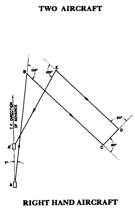
AERIAL ESCORT PLAN KING

TWO AIRCRAFT


Table 1. Effective Visibility 7 Miles or More
4 5 6 7 8 9 10 11 12 13 14 15
First Course 7° R 7° R 7° R 7° R 7° R 7° R 7° R 7° R 7° R 7° R 7° R 7° R
AB (miles) 85.5 73.9 66.8 61.9 58.4 55.7 53.6 51.9 50.6 49.4 48.4 47.6
Change Course 128° R 128° R 128° R 128° R 128° R 128° R 128° R 128° R 128° R 128° R 128° R 128° R
BC (miles) 43.5 45.5 46.8 47.6 48.2 48.7 49.0 49.3 49.6 49.8 49.9 50.1
Change Course 90° L 90° L 90° L 90° L 90° L 90° L 90° L 90° L 90° L 90° L 90° L 90° L
CD (miles) 10 10 10 10 10 10 10 10 10 10 10 10
Change Course 90° L 90° L 90° L 90° L 90° L 90° L 90° L 90° L 90° L 90° L 90° L 90° L
DE (miles) 40 40 40 40 40 40 40 40 40 40 40 40
Change Course 105° L 105° L 105° L 105° L 105° L 105° L 105° L 105° L 105° L 105° L 105° L 105° L
EA' (miles) 40 40 40 40 40 40 40 40 40 40 40 40
T.F. goes from A to A' AA' (miles) 54.8 41.9 33.9 28.5 24.6 21.6 19.3 17.4 15.8 14.6 13.5 12.5
NOTE: Above table is for RIGHT HAND AIRCRAFT. For LEFT HAND AIRCRAFT, make first course and subsequent changes in directions OPPOSITE those given in table.


Table 2. Effective Visibility Under 7 Miles
4 5 6 7 8 9 10 11 12 13 14 15
First Course 7° R 7° R 7° R 7° R 7° R 7° R 7° R 7° R 7° R 7° R 7° R 7° R
AB (miles) 51.3 44.3 40.1 37.1 35.0 33.4 32.2 31.1 30.4 29.6 29.0 28.6
Change Course 128° R 128° R 128° R 128° R 128° R 128° R 128° R 128° R 128° R 128° R 128° R 128° R
BC (miles) 26.1 27.3 28.1 28.6 28.9 29.2 29.4 29.6 29.8 29.9 29.9 30.0
Change Course 90° L 90° L 90° L 90° L 90° L 90° L 90° L 90° L 90° L 90° L 90° L 90° L
CD (miles) 6 6 6 6 6 6 6 6 6 6 6 6
Change Course 90° L 90° L 90° L 90° L 90° L 90° L 90° L 90° L 90° L 90° L 90° L 90° L
DE (miles) 24 24 24 24 24 24 24 24 24 24 24 24
Change Course 105° L 105° L 105° L 105° L 105° L 105° L 105° L 105° L 105° L 105° L 105° L 105° L
EA' (miles) 24 24 24 24 24 24 24 24 24 24 24 24
T.F. goes from A to A' AA' (miles) 32.9 25.1 20.3 17.1 14.8 13.0 11.6 10.4 9.5 8.8 8.1 7.5
NOTE: Above table is for RIGHT HAND AIRCRAFT. For LEFT HAND AIRCRAFT, make first course and subsequent changes in directions OPPOSITE those given in table.


PLAN KING

Plan JIG

NOTE: Effective visibility is obtained for radar search from Table 1 (Article 2231) and for visual search from Table 2 (Article 2261). Use values for surfaced submarines.

[5-18]

    1.  

AERIAL ESCORT PLAN LOVE

THREE AIRCRAFT


Center Aircraft
4 5 6 7 8 9 10 11 12 13 14 15
First Course 7° L 7° L 7° L 7° L 7° L 7° L 7° L 7° L 7° L 7° L 7° L 7° L
AB (miles) 87.7 76.8 70.4 66.2 63.3 61.1 59.4 58.1 57.0 56.0 55.3 54.6
Change Course 120° R 120° R 120° R 120° R 120° R 120° R 120° R 120° R 120° R 120° R 120° R 120° R
BC (miles) 28.6 27.1 26.3 25.7 25.4 25.0 24.8 24.7 24.5 24.4 24.3 24.2
Change Course 90° R 90° R 90° R 90° R 90° R 90° R 90° R 90° R 90° R 90° R 90° R 90° R
CA' (miles) 40 40 40 40 40 40 40 40 40 40 40 40
T.F. goes from A to A' AA' (miles) 39.1 28.8 22.8 18.9 16.1 14.0 12.4 11.2 10.1 9.3 8.5 7.9
NOTE: Above table is for RIGHT HAND AIRCRAFT. For LEFT HAND AIRCRAFT, make first course and subsequent changes in directions OPPOSITE those given in table.


Right Hand Aircraft
4 5 6 7 8 9 10 11 12 13 14 15
First Course 30° R 30° R 30° R 30° R 30° R 30° R 30° R 30° R 30° R 30° R 30° R 30° R
AD (miles) 44 44 44 44 44 44 44 44 44 44 44 44
Change Course 150° R 150° R 150° R 150° R 150° R 150° R 150° R 150° R 150° R 150° R 150° R 150° R
DE (miles) 31.2 30.1 29.5 29.1 28.8 28.6 28.4 28.3 28.2 28.2 28.1 28.0
Change Course 90° L 90° L 90° L 90° L 90° L 90° L 90° L 90° L 90° L 90° L 90° L 90° L
EF (miles) 4 4 4 4 4 4 4 4 4 4 4 4
Change Course 90° L 90° L 90° L 90° L 90° L 90° L 90° L 90° L 90° L 90° L 90° L 90° L
FG (miles) 47.2 35.8 29.2 24.8 21.8 19.6 17.8 16.4 15.2 14.3 13.5 12.8
Change Course 105° L 105° L 105° L 105° L 105° L 105° L 105° L 105° L 105° L 105° L 105° L 105° L
GA' (miles) 30 30 30 30 30 30 30 30 30 30 30 30
T.F. goes from A to A' AA' (miles) 39.1 28.8 22.8 18.9 16.1 14.0 12.4 11.2 10.1 9.3 8.5 7.9
NOTE: Above table is for RIGHT HAND AIRCRAFT. For LEFT HAND AIRCRAFT, make first course and subsequent changes in directions OPPOSITE those given in table.


Plan JIG

[5-19]

  1. The following British patrols and searches are included for information and for use when needed in connection with joint U.S. - British operations. They may also be used when a threat is localized in a certain direction in addition to the Aerial Escort Plans, (Articles 5450, 5460 and 5470) which remain the basic plans for convoy protection. These patrols and searches will be designated by their patrol names.

PATROL NAME ACTION BY AIRCRAFT   OCCASION FOR USE
5481 COBRA (Y) Patrol around convoy at a distance of (Y) miles.   Normal day conditions. No indication of shadowing S/M. S/M known to be in vicinity but bearing unknown.
5482 CROCODILE (Y) Patrol ahead of convoy from beam to beam at radius (Y) miles.   With fast convoys.
5483 VIPER Patrol around convoy at visibility distance.   By day in condition of poor and/or variable visibility when S/M are known to be in the vicinity. For general use at night.
5484 ADDER Patrol ahead of convoy at distance of 8 to 12 miles, length of patrol 15 miles either side of center line.   By day when attack is expected.
5485 ALLIGATOR
"PORT" or "STARBOARD"
Patrol on side indicated at distance of 10 miles from convoy along line parallel to convoy's advance, length of patrol 10 miles ahead and astern of beam bearing.   When circumstances render a beam patrol desirable.
5486 FROG Patrol astern of convoy at distance of (Y) miles. Length of patrol to be 2 (Y) miles either side of center line.   To detect submarines trailing the convoy. Use at dusk prior to alteration of course by convoy.
5487 (X) PYTHON (Y) Search on (X) bearing for S/M (Y) miles distant. Aircraft will carry out square search around this position for 20 minutes using 2 mile visibility.   When S/M has been detected by D/F bearings and its distance determined.
5488 (X) MAMBA Search on (X) bearing for distance of 30 miles and return.   When S/M has been detected by D/F bearing but distance is unknown.
5489 (X) LIZARD (Y) Search (X) sector to a distance of (Y) miles. Sectors from true north as follows:
A - 000 to 060
B - 060 to 120
C - 120 to 180
D - 180 to 240
E - 240 to 300
F - 300 to 360
  When a special area is suspected (may be used at night).
54810 (X) REPTILE (Y) Search on (X) bearing to a distance of (Y) miles for a submarine detected by D/F bearing. If nothing is sighted, act in accordance with previous instructions.   When S/M has been detected by D/F bearings.
NOTES: (1) All bearings are true.
(2) All distances are from the nearest edge of the convoy.

[5-20]

5500 SAFETY OF CONVOY AFTER SUBMARINE SIGHTING OR ATTACK.

  1. A plane shall be kept available as a relief for continuation of escort, or to permit carrying on hold-down tactics, in the event of a contact or attack by one in the air. Where practicable, a striking group shall be maintained in readiness for immediate launching.

  1. At first opportunity after a sighting and without delaying attack, the aircraft sighting the enemy in the vicinity of the convoy is to report to the Escort Commander, or to the Carrier Commander, if applicable, by plain language voice or radio on the air coverage frequency. This report is to be followed by radio report to base as soon as possible. An amplifying report using either voice or key plain language or code, as the circumstances may warrant, shall be sent as soon as practicable.

  1. If sighting or an attack is made by an aircraft covering an unescorted merchant ship, the pilot shall fire the pyrotechnic signals specified in WIMS 1 denoting, "Submarine below me", and broadcast a warning to the ship in plain language on the International Distress frequency. (See Article 6052.)

  1. When a submarine submerges in such position that it remains a potential hazard to the safety of any ship in the convoy, if sufficient planes are available to conduct an Aerial Escort Plan and also hold-down tactics, it should be held down until its point of submergence draws abaft the convoy's quarters and is at least 25 miles from the nearest ship of the convoy.
    1. When a submarine is seen to submerge in the 90° rear section and more than 25 miles from the convoy, it should be held down only if it is known that assisting craft will arrive within two hours, and then only until the surface craft abandon the hunt.
    2. Use aircraft radar continuously during the hold-down.

  1. After a submarine has been attacked or submerges, the plane should, if practicable, climb over the spot to an altitude that will enable radar-equipped surface vessels to obtain a radar fix.


5600 DEPARTURE FROM CONVOY.

  1. When leaving the convoy during daylight to return to base, if time and weather permit, the aircraft shall notify the Escort Commander that he is departing. If the time of departure from the convoy has been delayed more than thirty minutes from the estimated time of departure the aircraft shall notify the base while enroute.

  1. Land-based aircraft shall obtain the convoy's position before parting company in daylight, and if a relief plane is expected, a position report shall be transmitted to base when the aircraft is fifty miles from the convoy.

  1. At night, relieving aircraft shall fly at 1500 feet or at the base of the clouds. The aircraft being relieved shall fly at 1000 feet, or at 300 feet below cloud base when the clouds are below 1000 feet. After relief, fly at any practicable altitude. Navigation lights may be turned on by the plane being relieved ten (10) minutes before the scheduled time of relief and kept burning until time of departure.

  1. Aircraft shall leave the convoy at the appointed time as there is little likelihood of contact being established between aircraft at night.

  1. Normally not more than one plane shall be assigned at any one time to a given night escort mission. Plane assigned shall fly with navigation lights extinguished, except when being relieved. If more than one plane is used they shall be assigned different patrol altitudes and sectors, with adequate safety margins between altitudes and sectors. Further tactics assigned to prevent simultaneous attack on the same target shall be adopted and thoroughly understood prior to take-off. In areas where no air opposition is expected, tactical lights which cannot be seen from below may be kept turned on.

[5-21]

5700 EMERGENCIES AND FORCED LANDINGS.

  1. If an aircraft wishes to indicate to a surface craft that a change of course should be made due to an emergency or to rescue survivors, the aircraft will, if necessary, first establish identification. It will then circle the ship at least once, flying across the bow of the ship at low altitude, opening and closing throttle, then fly on the course desired to be taken rocking the wings. This procedure will be repeated until the ship has acknowledged by following the aircraft.
    1. If possible, the aircraft will maintain visual contact with the ship until the latter sights the plane or ship in distress or the survivors thereof.

  1. If a forced landing becomes necessary, carry out emergency procedure prescribed for applicable aircraft type in Current Tactical Orders and Doctrine, U.S. Fleet Aircraft (USF 74, 75, 76).
    1. Jettison all bombs in a clear area.
    2. If the landing is made in the vicinity of a convoy, land about 1000 yards ahead of an Escort Ship or Merchant Ship on the flank.


5800 ENEMY AIR OPPOSITION.

  1. When convoys are routed through areas where air opposition is likely to be encountered, fighter protection sufficient to meet the degree of threat shall be provided.

  1. If capable of countering air opposition, any aircraft detailed to the escort of convoy may be employed against enemy air attacks. The operational control of aircraft assigned to this task shall be the same as in anti-submarine escort.

  1. Standard Fighter Director Procedures shall be employed by aircraft carriers in meeting enemy aerial threats. When the Escort Commander is exercising control of covering aircraft instructions should be passed in plain language voice radio.
    1. While awaiting intercept and attack instructions the patrolling aircraft shall remain within visibility distance of the convoy outside the 3000 yard approach limit if possible.
    2. If the aircraft departs from the vicinity of the convoy beyond visibility distance at any time during the patrol, it will be necessary to repeat recognition procedure upon returning to the convoy.
    3. Every means should be employed to assist the surface units in establishing and maintaining friendly identification of patrolling aircraft.

[5-22]

5900 AIRSHIPS.

  1. Airships may be employed advantageously to assist in the controlling of the convoy during sortie, the formation after sortie, the location and controlling of joiners, the location and controlling of stragglers and rompers. The slow speed of these aircraft permit their use to relay word verbally or visually between the Escort Commander and ships under his control as an effective substitute or supplement to other mediums of communication. To obtain the maximum benefit from this employment, the airship pilot should, when practicable, attend the pre-sailing conference or should be furnished with full information as to the formation and initial movements of the convoy.

  1. It is not practicable to prescribe tracks which airships shall fly in escort of convoy operations. Therefore, airships when escorting convoys shall patrol areas rather than fly prescribed tracks.

  1. The basic area for an airship escorting a convoy is similar in shape to a rubber life raft with both ends rounded. The center area, which shall not be patrolled, is the area occupied by the convoy surrounded by a 2000 yard wide strip. The outer boundary of the basic area is 500 yards outboard of the inner boundary abeam of the convoy, and 10,000 yards outboard of the inner boundary ahead and astern of the convoy.

  1. With only one airship present, that portion of the basic area which lies forward of the convoy's bows shall be given primary consideration.

  1. With two airships present, that part of the basic area which lies forward of the convoy's beams shall be given primary consideration. If the convoy is a fast convoy, this may require that the area patrolled extend not quite as far aft as the convoys beams.

  1. With three or more airships present, one should be assigned that part of the basic area which lies abaft the convoy's beams, unless the high speed of the convoy makes it necessary to have part of the after patrol are unattended.

  1. In all cases where specific altitudes are directed, airships will conform as nearly as practicable within their altitude limitations.

[5-23]

Table of Contents
 Previous Part (IV)    Next Part (VI)


Transcribed and formatted for HTML by Rick Pitz for the HyperWar Foundation