Lighthouses of the United States: Alaska

The United States of America is a federal union of 50 states and a capital district. The state of Alaska occupies the northwestern corner of North America, separated fron the rest of the continental United States by Yukon Territory and British Columbia, Canada. Alaska was part of Russia's claim to northwestern North America as early as 1734, and the first Russian settlements in Alaska date from the late 1700s. The U.S. bought the territory from Russia in 1867. Initially governed as a military district, Alaska became an incorporated territory in 1912 and was admitted to the union as the 49th state in 1959. Alaska is by far the largest U.S. state but it is sparsely populated, with a population of 736,000 in the 2020 census.

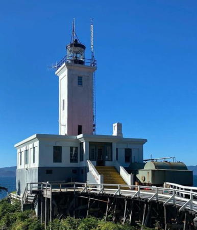
There were no lighthouses in Alaska until late in the 1800s when the discovery of gold in Canada's neighboring Yukon Territory brought a rush of settlers and commerce to the southeastern coastal region. Eldred Rock Light is the only survivor from the first series of quickly-built wooden lighthouses. The other early lights were replaced in the 1920s and 1930s by an interesting group of Art Deco concrete towers like the Tree Point Light shown at right. Historic lighthouses are found along the Inside Passage behind and between the islands of the southeastern "panhandle" region and along the south coast facing the Pacific Ocean. There are no lighthouses and few navigation lights of any kind on the state's west coast facing the Bering Sea and its north coast facing the Arctic Ocean.

Alaska is the only U.S. state not divided into counties, but the state legislature has established boroughs to provide regional government in some of the more populated areas.

Navigational aids in the United States are operated by the U.S. Coast Guard Seventeenth District, in particular the Aids to Navigation Team Kodiak, but ownership (and sometimes operation) of historic lighthouses has been transferred to local authorities and preservation organizations in many cases.

ARLHS numbers are from the ARLHS World List of Lights. Admiralty numbers are from Volume G of the Admiralty List of Lights & Fog Signals. USCG numbers are from volume 6 of the U.S. Coast Guard List of Lights.

General Sources
Alaska Lighthouses
Excellent photos and informative accounts from Kraig Anderson.
Online List of Lights - U.S. West Coast
Photos by various photographers posted by Alexander Trabas. For Alaska the photos are by Michael Boucher and Rainer Arndt.
Lighthouses in Alaska
Photos by various photographers available from Wikimedia.
World of Lighthouses - Northwest Coast of U.S.
Photos by various photographers available from Lightphotos.net.
U.S. Coast Guard Navigation Center: Light Lists
The USCG Light List can be downloaded in pdf format.
NOAA Nautical Charts
Official nautical charts for the coast can be viewed online.
Navionics Charts
Navigation chart for Alaska.

Tree Point Light
Tree Point Light, Revillagigedo Channel, about 2010
photo copyright Michael Boucher; used by permission

Inside Passage Lighthouses

The Inside Passage is the network of waterways behind and between the numerous islands of the Pacific coast, from Seattle northward into Alaska. Nearly all of the Passage is sheltered from Pacific storms by the islands, but strong tidal currents and many underwater obstacles make it hazardous to navigate. Ferries and cruise ships sailing the passage are the principal means of surface transportation everywhere along this coast. Many of the lighthouses in this group can be photographed at close range from passing cruise ships.

Ketchikan Gateway Borough: Revillagigedo Channel Lighthouses
Broad in the south, the Revillagigedo Channel gradually narrows to the Tongass Narrows, a strait that passes the town of Ketchikan.
Tree Point (2)
1935 (station established 1905). Active; focal plane 86 ft (26 m); white flash every 6 s. 66 ft (20 m) square cylindrical reinforced concrete tower with lantern, attached to an oil house. Lighthouse is white concrete; lantern painted red. The lantern was transferred from the 1905 lighthouse. The original 4th order Fresnel lens (1905), removed in 1968, is on display at the Tongass Historical Museum in Ketchikan. One of the three former keeper's houses survives, but in poor condition. Boucher's aerial photo is at the top of this page, Trabas has a closeup by Tom Chisholm, a 2009 view from sea is available, Johnny Rice has a 2022 drone view, and Bing has a distant satellite view. The Coast Guard has a photo of the original lighthouse and Lighthouse Digest has Anderson's 2012 article on the station's history. In November 2004 the light station was added to the National Register of Historic Places. Now gravely endangered by lack of maintenance, the lighthouse was added to the Lighthouse Digest Doomsday List in 2014. Located on the mainland overlooking the Revillagigedo Channel about 6 miles (10 km) north of the Canadian border, within the Misty Fiords National Monument (part of the Tongass National Forest). Accessible only by boat or float plane; best seen from the Inland Passage or on air tours from Ketchikan. Site open, tower closed. Owner/site manager: U.S. Coast Guard. ARLHS ALK-012; Admiralty G6002; NGA 111-11156; CCG P-0762; USCG 6-21840.
Black Rock
Date unknown (station established 1917). Active; focal plane 55 ft (17 m); white flash every 6 s. 9 m (30 ft) square skeletal tower carrying diamond-shaped daymarks colored in a red and white checkerboard pattern. Trabas has Darlene Chisholm's photo and Bing has an indistinct satellite view of the islet. Located on a rock about 7 mi (11 km) southeast of the Mary Island lighthouse. Accessible only by boat, but there should be a good view from ships on the Inland Passage. Site open, tower closed. Owner/site manager: U.S. Coast Guard. Admiralty G6004; USCG 6-21930.
Mary Island (2)
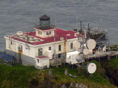
1937 (station established 1903). Active; focal plane 76 ft (23 m); white flash every 6 s. 61 ft (18.5 m) square cylindrical reinforced concrete tower on the roof of square concrete fog signal building; 250 mm lens. The original 4th order Fresnel lens is on display at the Juneau-Douglas City Museum in Juneau. All the other station buildings have been demolished. Trabas has Tom Chisholm's photo (also seen at right), a 2009 photo is available, Anderson has a 2005 photo, and Google has a satellite view. The lighthouse is reported to be endangered by lack of maintenance. Located on the northeast coast of Mary Island in the Revillagigedo Channel south of Ketchikan. Accessible only by boat or float plane, and landing is not easy. Site open, tower closed. Owner/site manager: U.S. Coast Guard. ARLHS ALK-009; Admiralty G6006; USCG 6-21940.

Mary Island Light, Revillagigedo Channel
photo copyright Tom Chisholm; used by permission
Hog Rocks
1907. Active; focal plane 23 ft (7 m); white flash every 4 s. 23 ft (7 m) round conical concrete tower. Trabas has Tom Chisholm's photo and Bing has a satellite view. Located on a reef about 20 mi (32 km) north of the Mary Island lighthouse. Accessible only by boat. Admiralty G6024; USCG 6-21950.
Spire Island Reef
Date unknown. Active; focal plane 30 ft (9 m); green flash every 4 s. 30 ft (9 m) square solid white concrete pyramid. Trabas has Darlene Chisholm's photo and Google has a satellite view. There are a number of lights on concrete pyramids along the Passage; this is one of the taller ones. Located on the west side of the channel near the north end of the Revillagigedo Channel. Accessible only by boat. Admiralty G6028; USCG 6-21965.

Ketchikan Gateway Borough: Ketchikan Area Lighthouses
The southernmost town of Alaska, Ketchikan has a population of about 14,000. The city faces the Tongass Narrows on the southwest side of Revillagigedo Island.
#Lightship WLV-196 Umatilla
1946 (Defoe Shipbuilding, Bay City, Michigan). Deactivated in 1971 and reported to have been scrapped in the early 2010s. 128 ft (39 m) two-masted steel lightship; beam 9 m (30 ft); lantern on the front mast. Ship painted white. Tom LeCompte has contributed photos taken in 2004 and Larry Myhre has a 2009 photo. The ship served at Pollack Rip and Nantucket Shoals in Massachusetts before being transferred to Umatilla Reef, Washington, in 1961. Long forgotten by lighthouse fans, the vessel was rediscovered by the Lightship Sailors Association in 2000. The ship was bought by Tom Faro, owner of Southeast Stevedoring, as a remote longshore camp for crews loading log ships. The ship was formerly moored at Pennock Island across the harbor from Ketchikan, but Anderson reports that in August 2007 it was moved to a new location north of the Ketchikan airport. When Darlene Chisholm visited Ketchikan in 2016 the ship was not present and she was told that it had been scrapped. Owner/site manager: private. ARLHS ALK-013.
Guard Island (2)
1924 (station established 1904). Active; focal plane 74 ft (22.5 m); white flash every 10 s. 30 ft (9 m) square cylindrical reinforced concrete tower with lantern and gallery, centered on the roof of a square concrete oil house; DCB-24 aerobeacon. Lighthouse is white concrete; lantern painted black. The keeper's house and other light station buildings were demolished in 1973. A photo by Lou Brutus is at right, Trabas has Tom Chisholm's photo, Larry Myhre has a photo, Micky Schembri has a 2017 photo, Ryan Falk has a 2023 photo, and Google has a satellite view. SitNews, the Sitka newspaper, has a feature article on life at the station in the 1950s. The Coast Guard has a photo of the original lighthouse, a square pyramidal wood tower with lantern and gallery. In 2000 a preservation group, Guard Island Heritage, was formed to seek ownership of the light station under NHLPA. Lighthouse Digest has Jeremy D'Entremont's 2001 article on the start of these efforts. In January 2004 the light station was listed on the National Register of Historic Places. The group had plans for restoration and tourist development but there have been no reports of recent activity. We need information on the current status of these efforts. Boat tours to view the lighthouse are available in the summer. Located on a island marking the northern entrance to the Tongass Narrows from Clarence Strait, 9 miles (15 km) northwest of Ketchikan. Accessible only by boat or float plane. There is a very distant view of the lighthouse from a turnout on the Tongass Highway (AK 7) north of Ketchikan (bring your binoculars). Site open, tower closed. Owner/site manager: U.S. Coast Guard. . ARLHS ALK-008; Admiralty G6046; USCG 6-22300.

Guard Island Light, Ketchikan, July 2013
Instagram photo by Lou Brutus

Wrangell Borough: Clarence Strait Lighthouses
Lincoln Rock (3?) (Lincoln Rock West)
Date unknown (station established 1903). Active; focal plane 58 ft (18 m); white flash every 6 s. Approx. 30 ft (9 m) square pyramidal steel skeletal tower built on the large concrete base of the 1903 lighthouse. Trabas has Darlene Chisholm's photo, a distant view from Lincoln Island is available, and Bing has an indistinct satellite view. The original lighthouse was abandoned in 1909 after being damaged by a storm. In 1911 a manned fog signal station was built on Lincoln Island about 440 yd (400 m) northeast of the rock, and a skeletal light tower was placed on the rock. The fog signal station was demolished after being deactivated in 1968 and only foundations of the buildings remain on the island (Google has a satellite view) along with the skeletal tower on the rock. Lighthouse Digest also has historic photos, including a 1940s photo of the skeletal tower. Located at the western end of Clarence Strait about 55 miles (90 km) northwest of Ketchikan. Accessible only boat. Site open, tower closed. Owner/site manager: U.S. Coast Guard. ARLHS ALK-024; Admiralty G6105; USCG 6-22470.
Key Reef
Date unknown. Active; focal plane 43 ft (13 m); white flash every 6 s. 39 ft (12 m) skeletal tower mounted on a square solid white concrete pyramid. A very distant sea view is available and Bing has a satellite view. This light marks the junction of Clarence Strait with Stikine Strait, which leads eastward toward Wrangell. Accessible only boat. Site open, tower closed. Owner/site manager: U.S. Coast Guard. Admiralty G6106; USCG 6-22480.
Bushy Island
Date unknown. Active; focal plane 22 ft (7 m); white flash every 4 s. 23 ft (7 m) round stone tower. Trabas has Boucher's fuzzy closeup photo, a very distant sea view is available, and Google has a satellite view. Located off the east side of Bushy Island at the north end of Clarence Strait. Accessible only boat. Site open, tower closed. Owner/site manager: U.S. Coast Guard. Admiralty G6112; USCG 6-22510.

Petersburg Borough Lighthouse
Petersburg is a town of about 3000 residents located roughly halfway between Ketchikan and Juneau.

Five Finger Islands (2)
1935 (station established 1902). Active; focal plane 81 ft (24.5 m); white flash every 10 s. 68 ft (20.5 m) square cylindrical reinforced concrete tower with lantern, centered on the roof of a square 1-story concrete keeper's house; solar-powered VRB-25 aerobeacon (1997). Lighthouse is white concrete; lantern painted black. One of Alaska's two oldest light stations. Kenneth Gill's photo is at right, Anderson has an excellent page for the lighthouse, Trabas has a photo by Charles Bash, a nice 2010 photo is available, Mário Ferreira has a 2023 closeup, and Bing has a satellite view. In the 1990s preservationists formed the Juneau Lighthouse Association and began working to restore the light station; a 1999 grant through the State of Alaska helped provide visitor access. In 2004 ownership of the light station was transferred to the preservation group and the lighthouse was added to the National Register of Historic Places. In 2011 the station became a summer base for whale researchers. Summer resident keepers work on restoration and repair projects. In 2020 the group reorganized as the Five Finger Lighthouse Society and changed its base of operations from Juneau to Petersburg. Fundraising for additional restoration is underway. Located on a small island in the entrance to the Stephens Passage on the southern approach to Juneau and about 40 mi (65 km) north northwest of Petersburg. Accessible only by boat or float plane. Site open, tower closed. Owner/site manager: Five Finger Lighthouse Society (Five Finger Lighthouse ). ARLHS ALK-007; Admiralty G6432; USCG 6-23280.


Five Finger Islands Light, Petersburg Borough, January 2023
Facebook photo posted by Five Finger Lighthouse


Juneau Area and Borough (Lower Lynn Canal) Lighthouses
Juneau, the capital of Alaska, is a city of about 33,000 residents. The city is located on the Gastineau Channel, a narrow strait separating the mainland from Douglas Island. The northern end of the Gastineau Channel is too shallow for navigation. Through traffic on the Inland Passage bypasses the city by the Stephens Passage to the south and west of Douglas Island. The Lynn Canal is not an artificial canal; it is a deep natural fjord 90 mi (140 km) long. The fjord leads to the towns of Haines and Skagway, the only two towns of Alaska's southeastern panhandle that have highway connections (through Canada) to the rest of the state.
Point Retreat (2)
1923 (station established 1904). Active; focal plane 63 ft (19 m); white flash every 6 s. 25 ft (7.5 m) square cylindrical reinforced concrete tower with lantern and gallery, mounted on the roof of a square concrete fog signal building. The original lantern was removed in the 1950s but it has been replaced by a replica. Solar-powered 300 mm lens. Lighthouse is white concrete; lantern painted black. 1-1/2 story wood keeper's house; a second keeper's house was demolished in 1966 to make way for a helicopter landing pad. James Brooks's photo is at right, Anderson has an excellent page with good photos, Trabas has Boucher's photo, Ed Hand has a photo, Larry Myhre has a distant view, and Google has a satellite view of the station. In 2000 a dispute broke out over ownership of the light station; the Alaska Lighthouse Association wants to develop the site as a tourist attraction but its plans were opposed by the U.S. Forest Service. ALA sought 1505 acres (609 ha) surrounding the lighthouse and the Forest Service wanted to lease only 10 acres (4 ha). In 2002 the entire 1505 acres were transferred to the ownership of the Association by act of Congress. ALA plans to locate a bed and breakfast in the keeper's house. Also in 2002 all the buildings were repainted by ALA volunteers. In July 2003 the lighthouse was added to the National Register of Historic Places. A replica of the original lantern room was under construction in 2010-11 and was installed during the summer of 2011. Located at the northernmost point of Admiralty Island west of Juneau, overlooking the entrance to the Lynn Canal. Note: Point Retreat is in an unincorporated area. In 2019 Juneau proposed to annex the area; in response residents of Admiralty Island proposed creation of a new Xunaa Borough. So far neither proposal has been submitted to the Local Boundary Commission. Accessible only by boat or float plane. Site open, tower closed. Owner/site manager: Alaska Lighthouse Association. . ARLHS ALK-010; Admiralty G6528; USCG 6-23955.

Point Retreat Light, Admiralty Island, May 2014
Flickr Creative Commons photo copyright James Brooks
** Sentinel Island (2)
1935 (station established 1902). Active; focal plane 86 ft (26 m); white flash every 10 s. 51 ft (15.5 m) square cylindrical reinforced concrete tower with lantern, rising from the front of a square concrete fog signal building; solar-powered VRB-25 aerobeacon (1997). The original 4th order Fresnel lens is on display at Alki Point Light in Seattle, Washington. The lighthouse is white concrete; lantern painted red. The keeper's house was burned in 1971. Wryan Webb's photo is at right, Trabas has Boucher's photo, Tyler Blevins has a photo, Charles Baxter has a view from the sea, and Google has a satellite view. One of Alaska's two oldest light stations. In 1998 a preservation group leased the lighthouse and opened it for custom day tours or overnight visitors. The society plans to establish a Southeast Alaska Maritime Interpretive Center. In April 2004 the light station was transferred to the Gastineau Channel Historical Society under NHLPA. Located on an island at the northern end of Favorite Channel about 25 miles (40 km) northwest of Juneau. Visible from AK 7. Accessible only by boat or float plane. Transportation to the light station can be arranged by Auke Bay Landing Craft, and the historical society offers tours during the summer months. Site and tower open for guided tours, group events, and overnight stays by appointment (call 907-586-5338). Owner/site manager: Gastineau Channel Historical Society (Sentinel Island Lighthouse) . ARLHS ALK-011; Admiralty G6538; USCG 6-23850.
Vanderbilt Reef
Date unknown. Active; focal plane 36 ft (11 m); white flash every 2.5 s. 32 ft (10 m) square skeletal tower mounted on a round 1-story stone base. Trabas has Boucher's photo and Google has a satellite view. Located about 3 mi (5 km) north northeast of the Sentinel Island lighthouse. Accessible only by boat. Site open, tower closed. Admiralty G6540; USCG 6-23860.

Sentinel Island Light, Juneau Borough, November 2021
Instagram photo by Wryan Webb
[Point Sherman (2)]
1981 (station established 1904). Active; focal plane 47 ft (14.5 m); white flash every 4 s. 6 m (20 ft) post, also carrying two diamond-shaped daymarkers painted in a red and white checkerboard pattern. The 1-1/2 story wood keeper's house of the original light station survives nearby in very poor condition. Trabas has Boucher's photo and Google has a satellite view. The original lighthouse was automated and reduced to a minor light in 1917. In 1932 it was replaced by a buoy offshore and presumably demolished. The present light stands on the original foundation. Located on a headland on the east side of the Lynn Canal about 40 mi (65 km) northwest of Juneau. Accessible only by boat. Site open. Owner: U.S. Coast Guard (tower) and U.S. Forest Service (keeper's house). Site manager: Tongass National Forest ARLHS ALK-015; Admiralty G6541; USCG 6-23865.

Haines Borough Lighthouses
Eldred Rock
1905. Active; focal plane 91 ft (28 m); white flash every 6 s. 56 ft (17 m) octagonal cylindrical wood tower with lantern and gallery, centered on the roof of 2-story octagonal wood keeper's house; solar-powered 250 mm lens. The original 4th order clamshell Fresnel lens was cleaned in 2001 and is on display at the Sheldon Museum in Haines. Lighthouse painted white, lantern and gallery black; the keeper's house roof is a conspicuous red. Julius Choudhury's photo is at right, Anderson has an excellent page for this lighthouse, Trabas has a good photo by Boucher, Rob Evans has a good photo, Arthur Chapman has a photo, and Google has a satellite view. This is the oldest lighthouse in Alaska and the only survivor of a series of octagonal frame lighthouses built in the state between 1902 and 1905. The lighthouse has been reported to be in disrepair, but in 2005 the Coast Guard painted the building, fixed the roof, and did other minor maintenance. The museum formed the Eldred Rock Lighthouse Committee to work for its restoration and hopes to request ownership under the National Historic Lighthouse Preservation Act. These plans have been blocked by the U.S. Forest Service, which has refused to relinquish the land on which the station stands. The Committee has now become the Eldred Rock Lighthouse Preservation Association . In 2019 the Association received a grant to support preparation of a historic structures, report, the first step to securing a lease. Then in early 2020 the Coast Guard granted the Association a five-year renewable lease of the light station. Volunteers began restoration work immediately with the goal of opening the lighthouse to tours. The Association has a video view of the lighthouse on Instagram. Located in the Lynn Canal on the approaches to Haines, a town of about 1700 residents at the head of the Lynn Canal. Accessible only by boat or float plane. Site and tower closed. Owner: U.S. Coast Guard. Site manager: Sheldon Museum and Cultural Center. ARLHS ALK-006; Admiralty G6543; USCG 6-23880.

Eldred Rock Light, Haines, August 2023
Facebook photo posted by ERLPA
The Sisters
Date unknown. Active; focal plane 69 ft (21 m); white flash every 4 s. Approx. 55 ft (17 m) square skeletal radio tower. Trabas has Arndt's photo and Google has a satellite view. The Sisters is an island in the center of Icy Strait, a 40 mi (65 km) long passage connecting the Lynn Canal to the Pacific Ocean at Cape Spencer. The tower carries an aerobeacon of the Federal Aviation Administration. Accessible only by boat. Site open, tower closed. Admiralty G6479; USCG 6-24135.

Southeast Alaska Pacific Coast Lighthouses

Lower Chatham Strait Area Lighthouse
Chatham Strait is a straight passage 150 miles (240 km) long leading almost due north from the sea at Cape Decision to join the Lynn Canal. It separates Chichagof Island and Baranof Island on the west from Admiralty Island and Kuiu Island on the east. The strait provides a direct passage from the Pacific to the Lynn Canal and Haines.
Cape Decision
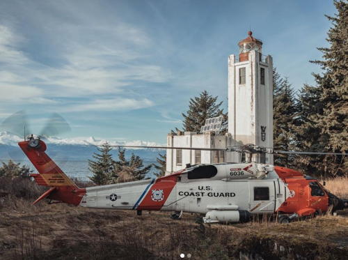
1932. Active; focal plane 96 ft (29 m); white flash every 5 s. 76 ft (23 m) square cylindrical reinforced concrete tower with lantern and gallery, mounted on the roof of a square concrete fog signal building; solar-powered VRB-25 aerobeacon (1996). The original 3rd order Fresnel lens is on display at the Clausen Museum in Petersburg. The lighthouse is white concrete; the lantern is painted black. Stena Troyer's photo is at right, Anderson has a fine page with good photos, Wryan Webb has a 2022 photo, Trabas has Darlene Chisholm's drone view, and Bing has a satellite view. In 2004 ownership of the lighthouse was transferred to the Cape Decision Lighthouse Society, which is working to restore the light station. In 2005 the station was added to the National Register of Historic Places. A state grant of $18,048 supported repairs to the windows of the lighthouse in 2015. Located at the southern end of Kuiu Island at the point between the entrances to the Chatham and Sumner Straits. Accessible only by boat or float plane. Site open, tower closed. Owner/site manager: Cape Decision Lighthouse Society . ARLHS ALK-001; Admiralty G6286; USCG 6-1020.

Sitka Borough Lighthouses
Sitka is a town of about 8500 residents located on the west side of Baranof Island. Alaska's oldest town, it was founded in 1804 and was the capital of the Russian territory of Alaska.

Rockwell (Sitka)
1985. Active (privately maintained); focal plane 50 ft (15 m); continuous red light. 42 ft (13 m) octagonal wood tower with lantern and gallery, attached to a 1-story wood bed and breakfast inn. Trabas has Charles Bash's photo, a 2019 photo is available, Duane and Shirleen Hymas have a good 2006 photo, and Google has a satellite view. The lighthouse marks the Rockwell Reef, 100 yards (90 m) offshore. In 2010 the inn and lighthouse were for sale for $1.5 million; by 2013 the price had been reduced to $799,000. The property sold in 2017 and the inn was renovated for the opening of the 2018 season. Located on Rockwell Island in Sitka harbor, about 3/4 mi (1.2 km) south of the city's waterfront. Accessible only by boat. Site and tower open, at least to guests of the inn. Owner/site manager: Sitka Lighthouse . ARLHS ALK-017; Admiralty G6393; USCG 6-24955.
[Fairway Island (3?)]
Date unknown (station established 1904). Active; focal plane 55 ft (17 m); red flash every 6 s. The modern light is a post carrying a triangular red daymark. A distant view is available but the small light is not seen in Google's satellite view of the island. The original lighthouse, a 10 ft (3 m) square wood tower with lantern was in operation for only a decade. Located on the north point of an island in the east entrance to the Peril Strait, which separates Baranof and Chichagof Islands. Accessible only by boat. Site status unknown. ARLHS ALK-021; Admiralty G6333; USCG 6-25310.

Cape Decision Light, Kuiu Island, August 2022
Instagram photo by Stena Troyer

Tenakee Springs Town Lighthouse
Tenakee Springs
Date unknown. Active (privately maintained); focal plane 20 ft (6 m); quick-flashing white light. This light is mounted at the seaward end of a private residence. No photo available but Google has an indistinct satellite view. Tenakee Springs is a village (population 130) on the north side of Tenakee Inlet, a fjord leading westward from Chatham Strait into Chichagof Island. Site open, tower closed. Owner/operator: private. Admiralty G6363; USCG 6-24084.

Glacier Bay Area Lighthouse
Cape Spencer
1925. Active; focal plane 105 ft (32 m); white flash every 10 s. 25 ft (7.5 m) square cylindrical reinforced concrete tower with lantern and gallery, centered on the roof of a square concrete keeper's quarters and fog signal building; solar-powered VRB-25 aerobeacon (1998). The original 3rd order Fresnel lens, removed in 1974, is on display at the Alaska State Museum in Juneau. Lighthouse painted white, lantern and gallery black; the keeper's house roof is a conspicuous red. Trabas has Darlene Chisholm's drone view seen at right, Travis Saunders has a photo of the light in action, Gabe Emerson has a view from the sea, Mike Criss has an aerial photo, and Bing has a satellite view. Wikimedia has a portfolio of historic photos. Located on the north side of the entrance to Cross Sound, the western approach from the Pacific to Juneau and Haines. Accessible only by boat or float plane. Site and tower closed. Owner: U.S. Coast Guard. Site manager: U.S. National Park Service (Glacier Bay National Park and Preserve). . ARLHS ALK-004; Admiralty G6508; USCG 6-1070.
 

Cape Spencer Light, Icy Strait
photo copyright Darlene Chisholm; used by permission
 

Southern Alaska Pacific Coast Lighthouses

Chugach (Valdez-Cordova) Area Lighthouses
Cape St. Elias
1916. Active; focal plane 85 ft (26 m); white flash every 10 s. 55 ft (17 m) square cylindrical reinforced concrete tower with lantern and gallery, rising from the corner of a square concrete fog signal building; solar-powered VRB-25 aerobeacon (1998). The original 3rd order Fresnel lens is on display at the Cordova Historical Museum in Cordova. 3-story brick keeper's quarters. The lighthouse is white concrete; lantern painted red. Jeremy Botz's photo is at right, Anderson has a fine page for the lighthouse, Wryan Webb has a 2021 photo, Keith Watson has a closeup, the Coast Guard has a dramatic historic photo, Lighthouse Digest featured the lighthouse in December 2000, and Google has a satellite view. One of the most remote of all U.S. lighthouses. Endangered: Keith Watson's 2018 photo shows it much in need of paint. A new preservation group began restoration in summer 2000 by repairing the roof of the keeper's quarters and renovating the building for overnight stays. The group has a GoFundMe page to help raise funds for their work. Meanwhile in Cordova the 3rd order lens was restored before being moved with the museum to the new Cordova Center. Located on the southwestern end of Kayak Island, which juts 25 miles (40 km) into the Pacific in the Chugach National Forest southeast of Prince William Sound. Accessible only by boat or helicopter. Site open, tower closed. Owner: U.S. Coast Guard. Site manager: Cape St. Elias Lighthouse Keepers Association . ARLHS ALK-005; Admiralty G6582; USCG 6-1100.
* Odiak Pharos
Late 1970s. Active (privately maintained); focal plane 26 ft (8 m); continuous white light. 18 ft (5.5 m) octagonal tower with a small lantern centered on an observation deck at the top. Anderson's page has several photos, Gary McDowell has a 2019 photo, Bernardo Hernandez has a 2014 photo, Lighthouse Digest has Jeremy D'Entremont's article on the lighthouse, and Google has a distant satellite view. This is the northernmost lighthouse in the U.S. It was built by Bob and Rose Arvidson, the original owners of the Cordova Rose Lodge. The current owners, Gaye and Gary McDowell, refurbished the lighthouse after buying the property in 1998. Located at 1315 Whitshed Road southwest of the waterfront of Cordova, a town of about 2600 residents. Site open, tower status uncertain. Owner/site manager: Cordova Rose Lodge . ARLHS ALK-018; Admiralty G6646; USCG 6-25625.

Cape St. Elias Light, Gulf of Alaska, May 2018
Google Maps photo by Jeremy Botz
Cape Hinchinbrook (2)
1934 (station established 1910). Active; focal plane 235 ft (71.5 m); white flash every 15 s. 67 ft (20 m) octagonal cylindrical reinforced concrete tower with lantern, attached to concrete fog signal building; solar-powered VRB-25 aerobeacon (1998). Lighthouse is white concrete; lantern painted black. 1-story reinforced concrete keeper's house. A photo by Jonathan Woods is at right and Bing has a satellite view of the station. The original 3rd order Fresnel lens, removed in 1967, is on display at the Valdez Museum in Valdez. The museum has proposed to build a replica of the earlier (1910) light tower in downtown Valdez. The Coast Guard has historic photos of the original lighthouse and the present lighthouse. Located on the east side of the entrance to Prince William Sound from the Pacific about 65 miles (105 km) south of Valdez. Site and tower closed. Owner: U.S. Coast Guard. Site manager: Chugach National Forest. ARLHS ALK-002; Admiralty G6592; USCG 6-1125.
Bligh Reef
Date unknown. Active; focal plane 59 ft (18 m); white flash every 4 s. 59 ft (18 m) post supported by four pyramidal piles and carrying diamond-shaped daymark panels painted with a red and white checkerboard pattern. A photo is available but the light is not shown in Google's satellite view. Bligh Reef is famous (or notorious) as the reef where the tanker Exxon Valdez ran aground on 24 March 1989. The site of the wreck was about 500 m (0.3 mi) west southwest of the light. Located off the west side of Bligh Island in Prince William Sound, marking the east side of the entrance to the Valdez Narrows. Accessible only by boat. Site open, tower closed. Admiralty G6652.5; USCG 6-25662.

Kenai Peninsula Borough Lighthouse
*
Homer Spit
Date unknown (before 1964). Active; focal plane 34 ft (10.5 m); green flash every 6 s. Approx. 26 ft (8 m) octagonal wood-shingled tower with lantern, mounted atop a 2-story motel. Building and tower painted gray, lantern red. The lantern is empty; the light is displayed from a short post on the lantern roof. A photo is available, Marko Grobelnik has a street view from the beach, Google has a satellite view, and the lighthouse also appears in a historic photo showing damage to the area following the 1964 Cook Inlet earthquake and tsunami. Homer is a town on the north side of the entrance to Kachemak Bay from Cook Inlet, south of Anchorage. Homer Spit is a 4.5 mi (7.5 km) gravel bar that extends across more than half the mouth of the bay. At the southeast end of the spit is a harbor, a ferry terminal of the Alaska Marine Highway, and a resort. The lighthouse is at the extreme end of the spit. Note: ARLHS incorrectly identifies this light with the faux lighthouse at the nearby Salty Dawg Saloon. Site open, tower closed. Owner/site manager: Land's End Resort. ARLHS ALK-025; Admiralty G6708; USCG 6-26200.

Cape Hinchinbrook Light, Prince William Sound, September 2021
Instagram photo by Jonathan Woods

Aleutian Islands Lighthouses

Aleutians East Borough: Unimak Island Lighthouses
Unimak, the largest and easternmost island of the Aleutian Islands, is separated from the mainland of the Alaska Peninsula by only a very narrow channel on the east end of the island. The much wider strait of Unimak Pass, at the western end of the island, is the principal route for vessels between the Pacific Ocean and Bering Sea. The historic light stations of Scotch Cap and Cape Sarichef guide vessels through the pass.
[Scotch Cap (4)]
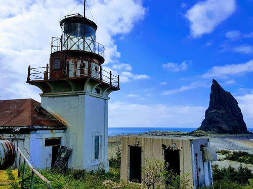
Date unknown (station established 1903). Active; focal plane 110 ft (33.5 m); white flash every 6 s. Approx. 8 m (26 ft) square skeletal tower with an open lantern and gallery. No current photo available but Google has a satellite view of the station. The second Scotch Cap Light, built in 1940, was destroyed by a tsunami on 1 April 1946, killing its 5 crew members. This disaster was the worst ever to befall a U.S. light station. In 1950 a fog signal building with a light on a short tower replaced the destroyed lighthouse; this structure has now been replaced by a skeletal light tower with no fog signal. Steven Bonnell's photo, at right, shows the ruins of the lost lighthouse; he also has a photo of the memorial plaque. The Coast Guard has a historic photo of the third (1950) lighthouse. The original lighthouse was a hexagonal wood tower centered on a 1-story keeper's house. Located on the southwestern coast of Unimak Island marking the southern entrance to Unimak Pass. Site closed. Site manager: U.S. Coast Guard. ARLHS ALK-016; Admiralty G6912; USCG 6-1220.
Cape Sarichef (3)
1950 (station established 1904). Inactive since 1979. Approx. 7 m (23 ft) short hexagonal tower mounted at one end of a white rectangular fog signal building. The active light (focal plane 170 ft (52 m); white flash every 2.5 s) is on a skeletal tower. Anderson has a good page for the light station, and Google has a satellite view of the station. Lighthouse Explorer's 1995 photo, contributed by Robert Deering, shows the skeletal tower in front of the 1950 lighthouse. This building was demolished in 1999. The original lighthouse was a hexagonal wood tower centered on a 1-story keeper's house. Located on the northwestern coast of Unimak Island marking the northern entrance to Unimak Pass. Site closed. Site manager: U.S. Coast Guard. ARLHS ALK-003. Active light: Admiralty G6916; USCG 6-1230.

1950 Scotch Cap Light and ruins of the 1940 lighthouse, 1973
photo copyright Steven Bonnell; used by permission

Information available on lost lighthouses

  • Point Hope (1924-?), Arctic Ocean. There is no longer a light at this location. ARLHS ALK-023.
  • Sitka (Baranof Castle) (1837-1877), Sitka. Established by the Russian government of Alaska. The "castle" burned in 1894. ARLHS ALK-022.

Notable faux lighthouses:

Adjoining pages: South: Northern British Columbia | West: Eastern Chokotka

Return to the Lighthouse Directory index | Ratings key

Checked and revised February 15, 2024. Lighthouses: 26; lightships: 1. Site copyright 2024 Russ Rowlett and the University of North Carolina at Chapel Hill.