Lighthouses of Northern Brazil

The Federative Republic of Brazil, the largest country in South America and fifth largest in the world, has a lengthy coastline, a large number of lighthouses, and a distinguished lighthouse history. Colonized by Portugal, Brazil declared its independence in 1822. Uniquely among American nations it was a monarchy as the Empire of Brazil until 1889.

Brazil is a federation of 26 states and a federal district. This page covers lighthouses on the coast of Brazil's North Region including the states of Amapá, Pará, and Amazonas. It is a tropical coastline, quite low in most areas. Belém in Pará is the major port. Tourism has increased in the region in recent years and some of the major lighthouses are becoming much better known.

Portuguese is the official language of Brazil. The Portuguese word for a lighthouse is farol, plural faróis. In Brazilian use the word farol generally applies to all light towers, regardless of size and whether they are enclosed structures or not. In Portuguese ilha is an island, ilhéu is an islet, cabo is a cape, ponta is a promontory or point of land, rocha is a rock, recife is a reef, baía is a bay, estreito is a strait, rio is a river, and porto is a port or harbor.

Active lighthouses in Brazil are owned by the navy (Marinha do Brasil) and maintained by the Centro de Auxílios à Navegação Almirante Moraes Rego (CAMR) in the Diretoria de Hidrografia e Navegacão (DHN). Many of the larger lighthouses are staffed by resident keepers or by rotating crews of naval personnel. Only a small number of Brazilian lighthouses are open to the public.

ARLHS numbers are from the ARLHS World List of Lights. BR numbers are from the official Brazilian Lista de Faroís. Admiralty numbers are from volume G of the Admiralty List of Lights & Fog Signals. U.S. NGA numbers are from Publication 110.

General Sources
Faroís Brasileiros
Published by the Navy, this web site for Brazilian lighthouses has small photos and historical information for many of the major lights.
Online List of Lights - Brazil
Photos by various photographers posted by Alexander Trabas. Most of the photos for this area are by Capt. Theo Hinrichs ("Capt. Theo") or Capt. Peter Mosselberger ("Capt. Peter").
Lighthouses in Brazil
Photos by various photographers available from Wikimedia.
World of Lighthouses - Brazil
Photos by various photographers available from Lighthouses.net.
Lista de Faróis do Brasil
Index to articles on Brazilian lighthouses in the Portuguese edition of Wikipedia.
Leuchttürme Südamerikas auf historischen Postkarten
Historic postcard views posted by Klaus Huelse.
Lista de Faróis
Online version of the official Brazilian light list.
Navionics Charts
Navigation chart for Brazil.


Salinópolis Light, Salinopolis, September 2022
Google Maps photo by Marcelo Cielo

Lighthouses of Amapá

 
The territory of Amapá (sometimes called "Portuguese Guiana") borders French Guiana and was disputed for many years between Brazil and France. In 1900 an arbitration commission ruled in favor of Brazil. The territory was added initially to the state of Pará. In 1943 it became a federal territory and it was elevated to statehood in 1991.

North Atlantic Coast Lighthouses
Cabo Orange
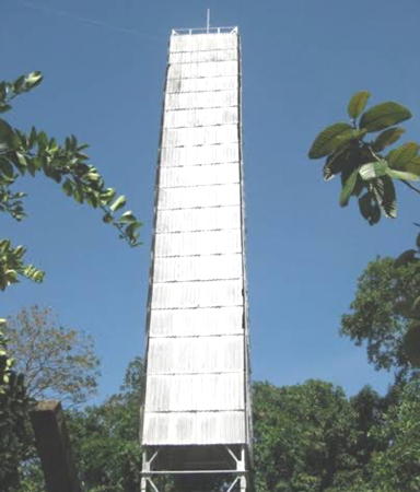
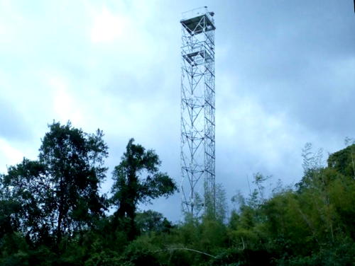
1997. Active; focal plane 50 m (164 ft); two white flashes every 15 s. Approx. 48 m (157 ft) square cylindrical white steel skeletal tower. A Navy photo is at right, Ricardo Siqueira has an aerial photo, the World Wildlife Fund also has an aerial photo, a distant view (second photo on the page) is available, and Bing has aa satellite view. This tall modern lighthouse was built on Brazil's northernmost cape, across the mouth of the Rio Oiapoque (Oyapock) from French Guiana, to mark the country's northern border. The lighthouse was restored in July 2012, although this was possible only after marines were sent in to clear the jungle from the helipad. The light was dropped from the Admiralty list in September 2019 but it remains in Brazil's 2024-25 Lista de Faroís. Accessible only by helicopter. Site open, tower closed. Site manager: Parque Nacional de Cabo Orange. ARLHS BRA-277; BR-0001; ex-Admiralty G0000.5; NGA 17458.
Rio Calçoene (2)
2006 (station established 1948). Active; focal plane 24 m (79 ft); white flash every 3 s. 20 m (66 ft) square skeletal tower, painted white. No photo available but Google has a satellite view of the station. Located at the water's edge on the south side of the entrance to the Rio Calçoene. Accessible only by boat. Site open, tower closed. ARLHS BRA-124; BR-0002; Admiralty G0001; NGA 17460.

Cabo Orange Light, Amapá, July 2012
Marinha do Brasil photo
Ponto do Guará
Date unknown. Active; focal plane 44 m (144 ft); white flash every 6 s. 42 m (138 ft) square skeletal tower, painted white. No photo available but Google has a satellite view. Located about 30 km (19 mi) north of the northernmost mouth of the Amazon River. Site status unknown. ARLHS BRA-217; BR-0028; Admiralty G0004; NGA 17470.
Bailique (2)
Date unknown (station established 1890). Active (?); focal plane 41 m (135 ft); white flash every 10 s. 39 m (128 ft) square skeletal tower, painted white. No photo available but Bing has a satellite view. The historic lighthouse was described as a cylindrical iron tower with a focal plane of 18 m (59 ft). The light was dropped from the Admiralty list in November 2019 but it remains in Brazil's 2022-23 Lista de Faroís. Located on the north side of the entrance to the northernmost mouth of the Amazon River. Site status unknown. ARLHS BRA-009; BR-0060; ex-Admiralty G0005; NGA 17472.

North Side Canal do Norte (Amazon River Entrance) Lighthouses
The Amazon Delta, one of the largest in the world, has two major navigable outlets, the Canal do Norte and the Canal do Sud, separated by several islands of the Marajó Archipelago. The Canal do Norte is the primary entrance for internationl shipping.

Ilha do Pará (2)
1990s (station established 1958). Active (?); focal plane 33 m (108 ft); three white flashes every 10 s. 30 m (98 ft) square skeletal tower covered with white metal panels. Aldeni Araujo de Almeida has the closeup photo seen at right, Trabas has a distant view by Capt. Theo, and Bing has a satellite view of the station. This lighthouse marks the entrance to the Canal do Norte, the northernmost major mouth of the Amazon. The Admiralty dropped the light in March 2021 but it remains in Brazil's 2024-25 Lista de Faroís. Located on an island just north of the entrance. Accessible only by boat. Site status unknown. ARLHS BRA-053; BR-0061; ex-Admiralty G0005.5; NGA 17474.

Ilha do Pará Light, Amapá, June 2018
Google Maps photo by Aldeni Araujo de Almeida
#Ilha Pedreira
Date unknown. Inactive. Lighthouse reported destroyed (presumably demolished) in early 2006. This was a 30 m (98 ft) square skeletal tower, painted white. No photo available but Google has a satellite view that probably shows buildings of the former station. Located on a swampy island in the Canal do Norte, the northernmost mouth of the Amazon, about 100 km (60 mi) above the mouth. Accessible only by boat. Site status unknown. ex-BR-0088; ex-Admiralty G0007.2; ex-NGA 17490.
Pau Cavado
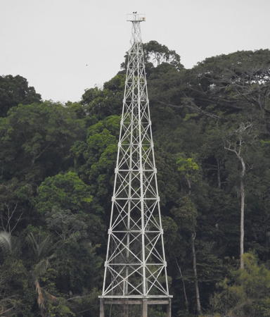
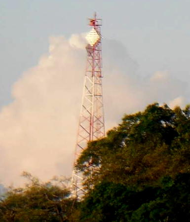
Date unknown. Active; focal plane 47 m (154 ft); white flash every 6 s. 40 m (131 ft) square pyramidal skeletal tower, painted white. Capt. Theo's photo is at right, Trabas has Capt. Peter's photo (also seen on a Lightphotos.net page) and Google has a good satellite view. Located at a bend in the Canal do Norte about 40 km (25 mi) northeast of the river port of Macapá. Accessible only by boat. Site status unknown. ARLHS BRA-069; BR-0092; Admiralty G0007.5; NGA 17500.
* Macapá Torre de Água (Water Tower)
Date unknown. Active (privately maintained); focal plane unknown; continuous light, white or red depending on direction. Light mounted atop a tall water tower. Trabas has Capt. Peter's photo and Google has a street view and a satellite view. Macapá, the capital of Amapá, is a city of about 400,000 residents on the north side of the Canal do Norte. Located at the intersection of the Avenidas Mário Cruz and Gen. Rondon in Macapá. Site open, tower closed. BR-0108; Admiralty G0008.4; NGA 17510.
* Macapá Southwest (Water Tower)
Date unknown. Active (privately maintained); focal plane unknown; continuous red light. Light mounted atop a tall water tower. Trabas has Capt. Peter's photo and Google has a street view and a satellite view. Located at the municipal water treatment plant on the Rua Odilado Silva in Macapá. Site open, tower closed. BR-0112; Admiralty G0008.5; NGA 17511.
Cascalheira
Date unknown. Active; focal plane 14 m (43 ft); two white flashes every 10 s. 14 m (46 ft) square white skeletal tower mounted on a square platform supported by piles. Trabas has Capt. Theo's photo and Google has a satellite view. The light warns ships away from a shoal on the north side of the Canal do Norte. Located off the southern edge of Macapá. Accessible only by boat. Site open, tower closed. BR-0116; Admiralty G0009; NGA 17512.

Pau Cavado Light, Amapá
photo copyright Capt. Theo Hinrichs; used by permission

Lighthouses of Pará

South Side Canal do Norte Lighthouses
Espírito Santo (2?)
Date unknown. Possibly replaced; listed with focal plane 24 m (79 ft); white light, 2 s on, 13 s off. 22 m (72 ft) square skeletal tower, painted white. Trabas has Capt. Theo's distant view showing the tower collapsing and no tower is seen in Google's satellite view. This lighthouse acts (or acted) as a leading light for vessels entering the Canal do Norte. The Admiralty listed the light as active in November 2019 but dropped it in March 2021. It remains on the Brazilian list for 2024-25. Located on the western end of the Ilha Caviana facing the south side of the Canal do Norte. Accessible only by boat. Site status unknown. BR-0084; ex-Admiralty G0007.4; NGA 17496.
Ilha Taiá
Date unknown. Active; focal plane 13 m (43 ft) three white flashes every 12 s. 13 m (43 ft) square skeletal mast painted white and mounted on a concrete pier. Trabas has Capt. Peter's photo and Bing has an indistinct satellite view. Located on a shoal northwest of the Ilha Janaucu on the south side of the entrance to the Canal do Norte. Site status unknown. BR-0076; Admiralty G0006.9; NGA 17488.
#Ponta do Santarém
Date unknown. Inactive since 2017 and probably demolished. This was a 13 m (43 ft) square skeletal tower painted white and mounted on a concrete pier. No photo available and the light is no longer seen in Bing's satellite view. Located just offshore off the northeast point of the Ilha Janaucu. Site status unknown. ex-BR-0072; ex-Admiralty G0006.8; ex-NGA 17484.

Ilha do Marajó Area Lighthouses
The Ilha do Marajó is a large island occupying much of the southeastern half of the delta of the Amazon. On its east side Marajó is separated from the mainland by the estuary known as the Rio do Pará. The Rio do Pará has been considered the southernmost mouth of the Amazon but more significantly it is the major mouth of the Rio Tocantins, another very large river. The city of Belém, capital of Pará state, is on the east side of the Río do Pará across from the Ilha do Marajó.

Ilha Camaleão
Date unknown. Active; focal plane 37 m (121 ft); one long (2 s) white flash every 15 s. 35 m (115 ft) square skeletal tower, painted white. No photo available but Bing has a satellite view. Located on the north side of the Ilha Camaleão, an island on the north side of the Ilha de Marajó. Accessible only by boat. Site status unknown. ARLHS BRA-136; BR-0142; Admiralty G0011.5; NGA 17534.
Ilha Machadinho
Date unknown. Active; focal plane 23 m (75 ft); white flash every 10 s. 20 m (66 ft) square skeletal tower, painted white. No photo available but Google has a satellite view. Located on an island about 16 km (10 mi) east of Ilha Camaleão. Accessible only by boat. Site status unknown. ARLHS BRA-226; BR-0144; Admiralty G0012; NGA 17536.
Simão Grande (Cabo de Maguari)
Date unknown. Active; focal plane 42 m (138 ft); white flash every 5 s. 40 m (131 ft) square skeletal tower, lower half pyramidal and upper half cylindrical, painted white. Osvaldo Boulhosa has an aerial view and Google has a satellite view of the tower. Located at the northeastern point of the Ilha de Marajó, marking the entrance to the Rio do Pará. Accessible only by boat. Site status unknown. ARLHS BRA-197; BR-0148; Admiralty G0014; NGA 17540.
* Soure (2)
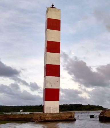
Date unknown (station established 1900). Active; focal plane 35 m (114 ft); two white flashes every 10 s. 30 m (98 ft) square cylindrical concrete tower, built on a square platform projecting into the Baía de Marajó. Lighthouse painted with red and white horizontal bands. Daniel Dutra's photo is at right, Giselle Silva has a 2017 photo, Flávio Lima has a 2021 photo, Trabas has a photo by Capt. Theo, and Google has a satellite view. Soure (pronounced "sorry") has about 25,000 residents and is the principal town of the Ilha de Marajó; it is accessible by ferry or package tour from Belém. Located in Soure on the west side of the entrance to the Baía de Guajará. Site open, tower closed. ARLHS BRA-198; BR-0167; Admiralty G0021.5; NGA 17560.

Soure Light,Ilha do Marajó, December 2018
Google Maps photo by Daniel Dutra
Salvaterra (Ilha dos Amores) (3?)
Date unknown. Active; focal plane 14 m (46 ft); white flash every 3 s. Approx. 12 m (39 ft) simple quadrupod tower. Oscar Chica has a 2024 photo and Google has a blurry satellite view. This light replaced a 12 m (39 ft) hexagonal skeletal tower with one enclosed section. Trabas has Capt. Theo's view of that light from the river, Edielson Correa Sarmento has a 2006 view from shore. The hexagonal tower may have been the second tower at this site, since NGA lists an 8 m (26 ft) square skeletal tower. Located on a small island just offshore at Salvaterra, on the west side of the Baía de Marajó. Site status unknown. ARLHS BRA-092; BR-0168; Admiralty G0022; NGA 17562.
* Joanes (Ponta da Guarita) (3)
Date unknown (station established 1889). Active; focal plane 23 m (75 ft); white flash every 10 s. 17 m (56 ft) square skeletal tower with gallery, painted white. A 2022 photo by Felipe Garcez is at right, Wikimedia has a 2007 photo by Celso Roberto de Abreu Silva, Trabas has a photo by Capt. Theo, and Google has a satellite view. There is a church near the lighthouse, and also nearby are the ruins of a 17th century mission that was one of the first European outposts in the area. Located on Ponta da Guarita, a promontory on the west side of the Baía de Marajó about 15 km (9 mi) south of Salvaterra. Site open, tower closed. ARLHS BRA-060; BR-0172; Admiralty G0024; NGA 17564.
Itaguari
Date unknown. Active; focal plane 12 m (39 ft); white flash every 5 s. 12 m (39 ft) square white concrete tower. Fabricio Ribeiro has a closeup photo and Google has a satellite view. Located on a shoal in the mouth of the Rio Marajó Acu opposite Belém. Accessible only by boat. Site open, tower closed. ARLHS BRA-251; BR-0308; Admiralty G0052; NGA 17600.
Ilha Mandií (?)
Date unknown. Active; focal plane 15 m (49 ft); white flash every 6 s. 11 m (36 ft) square skeletal tower carrying white daymark panels. Two station buildings. No photo available and the tower is not seen in Google's satellite view. The Admiralty dropped its listing of this light in March 2021 but it remains in Brazil's 2024-25 Lista de Faroís. Located on an island on the south side of the Ilha Marajó. Accessible only by boat. Site open, tower closed. BR-0324; ex-Admiralty G0054; NGA 17624.
Ponta do Frechal
Date unknown. Active; focal plane 23 m (75 ft); green flash every 5 s. 20 m (66 ft) square white skeletal tower. No photo available but Bing has a satellite view. This light marks the south side of the entrance to the Canal Sul, the narrow waterway on the southern eddge of the Ilha Marajó. Accessible only by boat. Site open, tower closed. BR-0345.1; Admiralty G0053.7; NGA 17634.

Joanes Light, Ilha do Marajó, May 2022
Google Maps photo by Felipe Garcez

Belém Area and South Side Rio Pará Lighthouses
Founded in 1616, Belém (Portuguese for Bethlehem) is the capital of Pará and the metropolis of the lower Amazon. The city has a population of about 1.5 million.
*** Belém (Mangal das Garças)
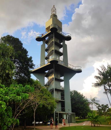
2005. Active; focal plane about 45 m (148 ft); white flash every 20 s. 47 m (154 ft) square concrete skeletal tower with lantern, four massive legs, a large square central column, and two observation decks. Bernardo Pastana's 2021 photo is at right, Giovane Carneiro has a photo, Wikimedia has several photos, Trabas has a photo by Alfonso Biescas Vignau, Matheus Zimmerman has a 2018 photo, Flávio Jota de Paula has a 2014 photo, and Google has a street view and a satellite view. This striking and very modern lighthouse is the centerpiece of a large park, the Mangal das Garças ("Mangroves of the Herons"), close to downtown Belém and at the confluence of the Rio Guamá and Rio Acará. Adjacent to the lighthouse is a maritime museum, the Memorial Amazônico da Navegação. Site open; tower open for climbing to the upper and lower observation decks. Site manager: Estado do Pará. . ARLHS BRA-291; BR-0269; Admiralty G0042.3; NGA 17599.
* Ilha Cotejuba
Date unknown. Active; focal plane 10 m (33 ft); white flash every 6 s. 8 m (26 ft) post rising from a square white concrete base; the post carries two diamond-shaped white daymarks. Trabas has Capt. Peter's photo, Ricardo Lima has a drone view, and Google has a satellite view. Located on a very popular beach on the Ilha Cotejuba, an island on the north side of Belém. Site open, tower closed. BR-0288; Admiralty G0036; NGA 17588.
[Forte da Barra (2)]
Date unknown (station established about 1923). Active; focal plane 14 m (43 ft); quick-flashing white light. This light is described by NGA as a 12 m (39 ft) square masonry tower, painted white, located on an islet in the Rio do Pará. However, the islet has disappeared and the current light is on a white mast mounted on a square concrete pier. A closeup photo is available, Davi Cardoso has a 2023 photo, and Google has a distant satellite view. Located about 600 m (3/8 mi) off the east side of the Rio do Pará at Val de Cães, about 10 miles north of Belém. Accessible only by boat. Site open, tower closed. ARLHS BRA-259; BR-0208; Admiralty G0038; NGA 17592.
Ilha Tatuoca
Date unknown. Active; focal plane 12 m (39 ft); two quick white flashes every 6 s. 11 m (36 ft) square skeletal tower painted white. Trabas has Capt. Peter's distant view and Google has a distant satellite view. This light marks the beginning of the approach to Belém from the Rio de Pará. Located at the northern tip of a small island in the estuary. Accessible only by boat. Site open, tower closed. BR-0192; Admiralty G0034; NGA 17584.

Belém (Mangal das Garças) Light, October 2021
Google Maps photo by Bernardo Pastana
[Colares]
Date unknown. Active; focal plane 14 m (46 ft); two white flashes every 6 s. 10 m (33 ft) post rising from a square white concrete base; the post carries a diamond-shaped white daymark. Silvia Monteiro has a 2023 closeup photo and Google has a satellite view. Located on an islet in the Rio do Pará about 1 km (0.6 mi) off the town of Colares. Site open, tower closed. BR-0176; Admiralty G0028; NGA 17568.
Ponta Maria Teresa
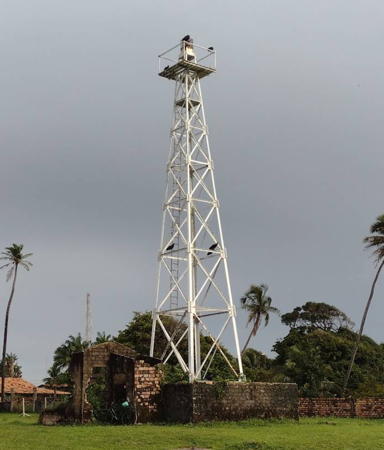
Date unknown. Active; focal plane 42 m (138 ft); white flash every 6 s. 40 m (131 ft) square cylindrical skeletal tower, painted white. Diogenes Pinheiro has the 2022 photo seen at right and Google has a satellite view of the lighthouse. Located on the east side of the Rio do Pará about 8 km (5 mi) north of Colares. Site status unknown. ARLHS BRA-079; BR-0164; Admiralty G0021; NGA 17556.
Taipú (2)
Date unknown. Active (?); focal plane 39 m (128 ft); three white flashes every 15 s. 30 m (98 ft) square skeletal tower, painted white. No photo available but Bing has a satellite view. The light was reported "extinguished" in 2013, but it was repaired and continues in service. Note: not to be confused with the much better known Morro de Taipus lighthouse in Bahia. This lighthouse is a landfall light for the entrance to Marajó Bay and the Rio do Pará. Located about 30 km (19 mi) north of Vigia. Site status unknown. ARLHS BRA-200; BR-0160; Admiralty G0020; NGA 17552.
Ponta Tijoca
Date unknown. Active; focal plane 35 m (115 ft); two white flashes every 10 s. 5 m (16 ft) square pyramidal skeletal tower painted with red and white horizontal bands. No photo available but Bing has an indistinct satellite view. Located atop dunes on the Ilha dos Guarás about 25 km (15 mi) northeast of the Taipú lighthouse. Site status unknown. ARLHS BRA-232; BR-0156; Admiralty G0018; NGA 17548.

Ponta Maria Teresa Light, Colares, April 2022
Google Maps photo by Diogenes Pinheiro

North Coast and Salinópolis Area Lighthouses
Curuçá (Ilha Cajutuba)
Date unknown (station established 1933). Active; focal plane 44 m (144 ft); three white flashes every 15 s. 42 m (138 ft) square pyramidal skeletal tower painted with red and white horizontal bands and carrying two white diamond-shaped daymarks. Sandro Santos has a photo (also seen at right) and Google has a satellite view. Located on the northern point of Ilha Cajutuba, about 50 km (30 mi) west of Salinópolis. Site status unknown.ARLHS BRA-031; BR-0472; Admiralty G0062; NGA 17652.
Marapanim (Ponta do Algodoal)
1952. Active; focal plane 34 m (112 ft); two white flashes every 10 s. 32 m (105 ft) square skeletal tower painted with red and white horizontal bands. Thais Valadares has a photo, Luiz Coltro has a distant street view from the beach, and Google has an indistinct satellite view. Located on a low point of land on the east side of the entrance to the Rio Marapanim, about 25 km (15 mi) west of Salinópolis. Site status unknown. ARLHS BRA-064; BR-0476; Admiralty G0063; NGA 17656.
* Salinópolis (Salinas) (3) (relocated from Apeú)
1902 (relocated here in 1937) (station established 1852). Active; focal plane 61 m (200 ft); white flash every 6 s. 39 m (128 ft) cast iron skeletal tower with central cylinder, painted red. Marcelo Cielo's 2022 photo is at the top of this page, Felipe Accioli has a good 2003 photo, Alexandre Lima has a photo, Moises Unger has a 2008 photo, Wikimedia has Carlos Macapuna's closeup, and Google has a street view and a satellite view. The lighthouse was prefabricated in what was then Austria but is now the Czech Republic. Stone ruins of the original lighthouse, a 12 m (40 ft) tower, can be seen on the beach 13 km (8 mi) north of the city. After it was lost to erosion it was replaced by a 50 m (164 ft) skeletal tower; this lighthouse was also lost to erosion in the 1930s. The present lighthouse was shipped to Salinópolis in 1894 but it remained crated for several years. In 1902 it was installed at Apeú (see below), where it stood until it was relocated to the present site in 1937. Located in Salinópolis, an ocean beach resort about 150 miles northeast of Belém. Site open, tower closed. . ARLHS BRA-091; BR-0480; Admiralty G0064; NGA 17660.

Curuçá Light, Ilha Cajutuba, August 2013
Google Maps photo by Sandro Santos
Quatipuru
Date unknown. Active (?); focal plane 27 m (89 ft); three white flashes every 15 s. 25 m (82 ft) skeletal tower, painted with red and white horizontal bands. No photo available and the light is not seen in Bing's fuzzy satellite view of the station. This light has been dropped from the Brazilian light list, but it remains on the Admiralty list. Located on a low point of land about 60 km (38 mi) northeast of Santarém. Site status unknown. ARLHS BRA-085; ex-BR-0482; Admiralty G0065; NGA 17662.
Caeté (Ajuruteua)
Date unknown. Active; focal plane 20 m (66 ft); two quick white flashes every 6 s. 16 m (52 ft) square skeletal tower, painted white. No photo available and the light has not been found in Google's satellite view. Located at the north end of the beach resort town of Ajuruteua on the west side of the entrance to the Rio Caete estuary. Site status unknown. ARLHS BRA-020; BR-0484; Admiralty G0066; NGA 17664.
Apeú (Ilha do Apeú, Cape Gurupi) (2)
1943 (station established 1902). Active; focal plane 41 m (135 ft); two white flashes every 15 s. 38 m (125 ft) square skeletal tower with gallery, painted with red and white horizontal bands. The tower also carries a diamond shaped daymark also painted with red and white horizontal bands. No photo available but Google has a satellite view of the tower. The original lighthouse was relocated to Salinópolis in 1937. The light was dropped from the Admiralty list in July 2018 but it remains in Brazil's 2022-23 Lista de Faroís. Located on an island just offshore about 120 km (75 mi) east of Salinópolis. Site status unknown. ARLHS BRA-004; BR-0488; ex-Admiralty G0070; NGA 17668.

Lighthouses of the Amazon River

Large ocean-going vessels (including cruise ships) can sail the Amazon River approximately 1500 km (930 mi) to Manaus, the capital of Amazonas state. Manaus is a large city with a population of about 2 million.

Pará Lightbeacon
[Ponta Peregrino]
Date unknown. Active; focal plane 13 m (43 ft); white flash every 4 s. 12 m (39 ft) skeletal mast, painted with red and white horizontal bands. The small tower is not seen in Bing's satellite view. There are numerous lights along the river; this is one of the larger ones. The light was dropped from the Admiralty list in November 2018 but it remains in Brazil's 2020-21 Lista de Faroís. Located on the north bank of the Amazon about 160 km (100 mi) east of Santarém. Site status unknown. BR-0392; ex-Admiralty G0059.2.

Amazonas Lighthouses
Porto Equador
Date unknown. Active; focal plane 10 m (33 ft); white flash every 3 s. 10 m (33 ft) square skeletal tower, lower section pyramidal, painted white. The tower also carries diamond-shaped slatted daymarks, painted white. Trabas has Capt. Theo's photo and Bing has an indistinct satellite view. Located on the south bank of the river near Urucurutiba. Site status unknown. BR-0424; Admiralty G0059.52.
Moronas
1929. Active; focal plane 15 m (49 ft); green flash every 3 s. 16 m (52 ft) round cylindrical concrete tower mounted on a tall, round stepped base. Lighthouse painted white; the base is unpainted. André Stern has a closeup photo, Wikimedia has two photos and Bing has a satellite view. Ships must pass between this lighthouse and the Pedra do Jacaré lighthouse (next entry). Located in mid-river about 35 km (22 mi) east of Manaus. Accessible only by boat. Site open, tower closed. ARLHS BRA-281; BR-0428; Admiralty G0059.6.
Pedra do Jacaré (3?)
2016 (station established 1924). Active; focal plane 15 m (49 ft); red flash every 3 s. 16 m (52 ft) round cylindrical concrete tower mounted on a tall, round stepped base. Lighthouse painted white; the base is unpainted. Trabas has a closeup photo by Günther Hess and Google has a satellite view. The lighthouse was rebuilt after a collision with a ferry in 2011. Another collision in 2014 toppled the tower, but the Navy announced that the lighthouse would be rebuilt again in 2015-16. Located in mid-river about 32 km (20 mi) east of Manaus and 2.5 km (1.5 mi) southwest of the Moronas lighthouse. Accessible only by boat. Site open, tower closed. ARLHS BRA-280; BR-0432; Admiralty G0059.8.
* Manaus Alfândega
1912(?). Active (unofficial); light characteristics unknown. Approx. 22 m (72 ft) square castellated masonry tower topped by a round fiberglass tower colored with black and white horizontal bands, adjacent to an ornate 3-story customs house. The tower is brown and white. Pierre Marc's 2024 photo is at right, J.B. Artes has a 2023 photo, a 2008 photo by Nicholas Laughlin shows the original lantern, another good photo is available, and Google has a street view and a satellite view. The Alfândega (customs house) of Manaus is one of the city's best-known landmarks; it was prefabricated in Britain, shipped to the Amazon, and reassembled stone by stone. The building is now the Port Captain's office. Located on the Avenida Marquesa da Santa Cruz in downtown Manaus, the capital of Amazonas, about 1200 km (750 mi) by air west of Belém. Site open, tower status unknown. ARLHS BRA-283.

Alfândega de Manaus, January 2024
Google Maps photo by Pierre Marc

Adjoining pages: North: French Guiana | South: North Northeast Coast

Return to the Lighthouse Directory index | Ratings key

Posted February 16, 2004. Checked and revised June 19, 2024. Lighthouses: 38. Site copyright 2024 Russ Rowlett and the University of North Carolina at Chapel Hill.