Lighthouses of France: Loire-Atlantique

France (officially the French Republic, République française) has coasts facing south on the Mediterranean Sea, west on the open Atlantic Ocean, and north on the English Channel (La Manche in French). Long a leader in lighthouse design, France has scores of famous and historic lighthouses. And it was a French engineer and physicist, Augustin-Jean Fresnel (1788-1837), who invented the powerful and beautiful lenses used in lighthouses around the world.

Mainland France is divided into 12 administrative regions (régions); in addition the island of Corsica is a region, as are five former French colonies overseas. The regions are subdivided into departments (départements). This page includes lighthouses of the west coast of France, south of Brittany, in the département of Loire-Atlantique. Historically part of Brittany but now part of the region known as Pays de la Loire (Country of the Loire), Loire-Atlantique includes the lower estuary of the Loire River and the historic port of Saint-Nazaire, famous for its shipyards. This coast faces the Bay of Biscay (known in France as the Golfe de Gascogne), the arm of the Atlantic between the peninsulas of Brittany and Spain. Unlike the rocky and deeply-indented coast of Brittany to the north this is a relatively low, sandy coast.

The French word for a lighthouse, phare, is often reserved for the larger coastal lighthouses; a smaller light or harbor light is called a feu (literally "fire," but here meaning "light") or a balise (beacon). The front light of a range (alignement) is the feu antérieur and the rear light is the feu postérieur. In French île is an island, cap is a cape, pointe is a promontory or point of land, roche is a rock, récife is a reef, baie is a bay, estuaire is an estuary or inlet, détroit is a strait, rivière is a river, and havre is a harbor.

Aids to navigation in France are maintained by the Bureau des Phares et Balises, an agency of the Direction des Affaires Maritimes (Directorate of Maritime Affairs). The Directorate has four regional offices (called Directions Interrégionale de la Mer, or DIRM) at Le Havre, Nantes, Bordeaux, and Marseille. Lights in La Vendée are managed by the DIRM Nord-Atlantique - Manche Ouest at Nantes.

ARLHS numbers are from the ARLHS World List of Lights. FR numbers are the French light list numbers, where known. Admiralty numbers are from volume D of the Admiralty List of Lights & Fog Signals. U.S. NGA List numbers are from Publication 113.

General Sources
Online List of Lights - France - Atlantic Coast
Photos by various photographers posted by Alexander Trabas. Many of the photos for the Loire Coast are by Capt. Peter Mosselberger ("Capt. Peter").
Phares d'Europe
A portion of a large, well known site maintained by Robert Guyomard and Carceller.
Phares de France
Another large and well known site, this one by Jean-Christophe Fichou.
Phareland, le Site des Phares de France
This comprehensive site has good photos and information about the major lighthouses.
Leuchttürme.net - Frankreich
Photos and notes by Malte Werning.
Lighthouses in Loire-Atlantique
Photos by various photographers available from Wikipedia.
Lighthouses in France
Aerial photos posted by Marinas.com.
Société Nationale pour le Patrimoine des Phares et Balises (S.N.P.B.)
The French national lighthouse preservation organization.
Französische Leuchttürme
Historic photos and postcard images posted by Klaus Huelse.
GPSNauticalCharts
Navigational chart information for the region.
Navionics Charts
Navigational chart for Loire-Atlantique.
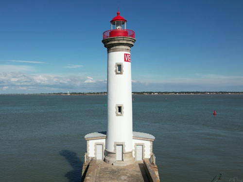

Vieux-Môle Light, St.-Nazaire, June 2021
Google Maps photo by Thms_pic Thomas


Jetée de Tréhic Light, Le Croisic, August 2008
Flickr Creative Commons photo by Emmanuel Parent
Pornic Area Lighthouses
* Pornic (Pointe de la Noëveillard)
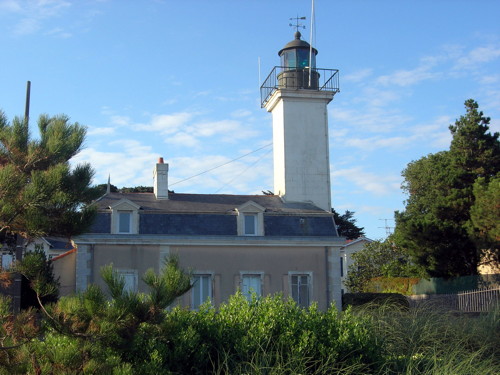
1846. Active; focal plane 23 m (75 ft); white, red, or green light, depending on direction, occulting four times every 12 s. 15 m (49 ft) square cylindrical limestone tower with lantern and gallery, attached to the front of a 1-1/2 story keeper's house. Tower painted white, lantern green. Rémi Jouan's photo is at right, Werning has a good photo, Trabas has a fine photo by Capt. Peter, Christelle Camus-Bouclainville has a closeup, Wikimedia has photos, Huelse has a historic postcard view, and Google has a street view and a satellite view. The lighthouse was originally 11 m (36 ft) in height; it was extended in 1882. In 1886 the keeper's house was also expanded. Located near a large marina on the west side of the entrance to the harbor of Pornic, on the Baie de Bourgneuf about 30 km (19 mi) south of Saint-Nazaire. Site open, tower closed except for monthly open house dates (reservations required). . ARLHS FRA-372; Admiralty D1156; NGA 1032.
*** Pointe Saint-Gildas
1941 (light mounted on 1861 signal station). Active; focal plane 20 m (66 ft); quick-flashing light, white, red, or green depending on direction. 17 m (56 ft) 3-story building with a short mast light on the roof. Building painted white, mast green. Werning has a fine closeup photo, Trabas has another good closeup by Stephen Hix, the Phareland site has numerous photos, Wikimedia has a 2011 photo, and Google has a street view and a satellite view. According to Fichou's account and Wikipedia's article it was German troops who first mounted a light on the 1861 signal station. The Bureau des Phares et Balises established a permanent light in 1955. From 1938 to 1993 there was a square pyramidal concrete observation tower atop the building; the light was in front of this tower. In the spring of 2005 the building was opened as a lighthouse and shipwreck museum; among the exhibits are a 4th order Fresnel lens and several buoys. Located at Pointe Saint-Gildas, marking the south side of the entrance to the Loire estuary, about 4 km (2.5 mi) west of La Plaine-sur-Mer. Site open; museum open daily in July and August, daily except Tuesdays March through June and September, and Wednesday through Sunday in October and November; visitors can climb to the top level just under the mast. Site manager: Sémaphore de la Pointe Saint-Gildas. . ARLHS FRA-479; FR-0979; Admiralty D1150; NGA 0912.
Pornic Light
Pointe de la Noëveillard Light, Pornic, August 2006
Wikimedia Creative Commons photo by Rémi Jouan

Loire Estuary South Side Lighthouses
* Saint-Michel-Chef-Chef (Port de Comberge) (South Breakwater) (1)
1965. Inactive. 6 m (20 ft) round cylindrical concrete tower with a castellated top. Hervé Therry has a 2020 closeup photo, a 2022 photo is available, and Google has a street view and a satellite view. Today this tower carries a small triangular daymarker, apparently serving as the rear beacon of a day range. Located on a spur of the south jetty at St.-Michel-Chef-Chef, a town on the south side of the Loire entrance about 7 km (4.5 mi) north of La Plaine-sur-Mer. Site open, tower closed.
* Saint-Michel-Chef-Chef (Port de Comberge) (South Breakwater) (2)
Date unknown (station established 1965). Active; focal plane 7 m (23 ft); white or green light, depending on direction, occulting once every 4 s. 5 m (16 ft) square cylindrical concrete tower with gallery. Trabas has Capt. Peter's photo, Hervé Therry has a 2020 closeup photo, and Google has a street view and a satellite view. Located on the south jetty at St.-Michel-Chef-Chef. Site open, tower closed. ARLHS FRA-593; Admiralty D1105; NGA 0920.
* Paimboeuf
1855. Active; focal plane 9 m (30 ft); white or green light, depending on direction, occulting three times every 12 s. 9 m (30 ft) round cylindrical limestone tower with lantern and gallery. Tower painted white, lantern and gallery green. Annick Monnier's photo is at right, Trabas has Capt. Peter's photo, Werning has an excellent photo, another good photo is available, Huelse has a historic postcard view, and Google has a street view and a satellite view. Located at the end of the breakwater sheltering the harbor of Paimboeuf, on the south side of the Loire estuary about 12 km (7.5 mi) east of Saint-Nazaire. Site open, tower closed. ARLHS FRA-378; Admiralty D1142; NGA 1028.

Loire Estuary North Side Lighthouse
Pierre Rouge
1875. Inactive for many years. This was a 10 m (33 ft) round stone tower, but the surviving tower appears to be about 5 m (17 ft) in height. Google has a satellite view. Located on a rock just off the north side of the river about 3 km (1.8 mi) above Paimboeuf. Site open; probably nothing prevents climbing the tower.

Paimboeuf Light, Paimboeuf, May 2013
Wikimedia Creative Commons photo by Annick Monnier

Saint-Nazaire Harbor Lighthouses
The city of Saint-Nazaire stretches along the north bank of the lower Loire estuary and includes the downstream neighborhoods of Ville-ès-Martin and Saint-Marc-sur-Mer. Famous for its ship-building, Saint-Nazaire is also a major fishing port. The city's metropolitan population is about 200,000.

*
Méan (feu postérieur)
1873. Inactive. The light was mounted on the gable end of a church, the Église de Méan. Google has a street view and a satellite view. Méan is a port neighborhood on the northeast side of downtown Saint-Nazaire. The range guided vessels into the entrance to the Rivière Brivet, which forms Méan's harbor. Located on the Place de l'Église, at the west end of the Avenue Ernest Renan in Méan. Site open, tower closed.
* Saint-Nazaire Vieux Môle (3)
1904 (station established 1834). Active; focal plane 18 m (59 ft); three white flashes in a 2+1 pattern every 12 s. 17 m (56 ft) round masonry tower with lantern and gallery, attached to a small equipment room. Tower painted white with unpainted stone trim; lantern and gallery painted red. A photo is also seen at the top of this page, Karl Adam has a nice photo, Werning has a good photo, Trabas has Capt. Peter's closeup, a 2022 photo and a 2017 closeup street view is available, and Google has a satellite view. Huelse has an interesting postcard view that shows the former Vieille Entrée light at the left and the 1836 Vieux Môle light in the distance. The Vieux Môle lighthouse was heavily damaged by an Allied bombing raid in April 1943; it was restored after the war using the original plans. Located at the end of the Vieux (Old) Môle, off the Quai des Marées about 800 m (1/2 mi) northeast of the Jetée de l'Est lighthouse. Site open, tower closed. ARLHS FRA-495; Admiralty D1126; NGA 0980.
* Saint-Nazaire Jetée de l'Est
1904. Active; focal plane 11 m (36 ft); green light occulting four times every 12 s. 10 m (33 ft) round masonry tower with lantern and gallery. Tower painted white with unpainted stone trim; lantern and gallery painted green. Werning has a photo, Trabas has Capt. Peter's closeup, a 2022 photo is available, Guyomard and Carceller have a photo, Huelse has a historic postcard view of both jetty lights, and Google has a street view and a satellite view. The west and east jetty lights mark the south entrance to the inner harbor, the Port de Saint-Nazaire, which is entered through locks that maintain a constant water level at the wharves. Located at the end of the east jetty protecting the south entrance to the Port de Saint-Nazaire. Site open, tower closed. ARLHS FRA-494; Admiralty D1124; NGA 0976.
* Saint-Nazaire Jetée de l'Ouest
1904. Active; focal plane 11 m (36 ft); red light occulting four times every 12 s. 10 m (33 ft) round masonry tower with lantern and gallery. Tower painted white with unpainted stone trim; lantern and gallery painted red. Antoine Turmel's photo is at right, Werning has a photo, Trabas has Eckhard Meyer's closeup, Txema Sanchez has a 2022 photo, Jérôme Perrais has a 2021 closeup photo, Guyomard and Carceller have a photo, Huelse has a historic postcard view of both jetty lights, and Google has a street view and a satellite view. Located at the end of the west jetty protecting the south entrance to the Port de Saint-Nazaire. Site open, tower closed. ARLHS FRA-496; Admiralty D1122; NGA 0972.

Ville-ès-Martin Lighthouses
Les Morées
1893 (light on 1777 daybeacon). Active; focal plane 12 m (39 ft); three flashes, red or white depending on direction, every 12 s. 17 m (56 ft) solid round granite tower with lantern, painted green. Built as a daybeacon, the tower was raised in height when its light was installed in 1893. A new lantern and a propane-fueled light were installed in 1954. Trabas has Capt. Peter's photo, a 2021 photo is available, and Google has a satellite view. Located on a rocky shoal, the Banc des Morées, about 1 km (0.6 mi) east of Ville-ès-Martin. Accessible only by boat. Site and tower closed. ARLHS FRA-363; Admiralty D1118; NGA 0968.

Jetée de l'Ouest Light, St. Nazaire, January 2013
Flickr Creative Commons photo by Antoine Turmel
* Ville-ès-Martin
1865. Active; focal plane 10 m (33 ft); two white flashes every 6 s. 12 m (39 ft) round granite tower with lantern and gallery. Tower is unpainted gray stone, lantern painted red. Trabas has a closeup, Werning has a good photo, Ric Ofeu has a closeup photo, Wikimedia has Ludovic Péron's photo, Guyomard and Carceller also have a photo, Huelse has a historic postcard view, and Google has a street view and a satellite view. This light and the Morées light (previous entry) frame the channel approaching the harbor of St.-Nazaire. Located at the end of an abandoned jetty just off a point of land about 2.5 km (1.5 mi) southwest of the Port de Saint-Nazaire. Apparently accessible at low tide from the riverfront along the Rue Ferdinand Buisson at the foot of the Rue du Port. Site open, tower closed. ARLHS FRA-535; Admiralty D1116; NGA 0964.
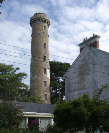
** Kerlédé (Portcé Feu Postérieur (1))
1897. Inactive since 1981. 26 m (85 ft) round granite tower with masonry lantern room and gallery, rising from the center of a 1-story keeper's house. Tower painted white; lantern room and gallery are unpainted granite. Sibling of the 1894 Port Maria lighthouse (see the Morbihan page). Werning has a good photo, Wikimedia has a closeup, a 2021 closeup by Stéphane Legars is available, Huelse has a historic postcard view, and Google has a street view and a satellite view. This handsome lighthouse had to be deactivated when another change in the channel required range lights on a new line. The lighthouse was bought in 1997 and renovated in 1998 by the city of Saint-Nazaire and operated as a museum by a non-profit group. In August 2004 this group disbanded and control of the lighthouse reverted to the city's ministry of culture. In September 2005 the lighthouse reopened under the management of the city's museum. Located off the Allée des Pervenches on the southwest side of Saint-Nazaire. Site open, tower open on Sunday afternoons May through October. Site manager: Écomusée Saint-Nazaire. . ARLHS FRA-510; ex-Admiralty D1106.1.
* Tour du Commerce (Portcé) (2)
1857 (station established 1756). Inactive since 1897. 39 m (128 ft) round masonry tower, painted white. Lantern removed; there appears to be a communications mast atop the capped tower. 2-story keeper's house. Florent Moritz's photo at right shows the tower and one end of the keeper's house, Werning also has a photo, Hervé Therry has a 2020 photo, a 2022 photo is available, Huelse has a historic postcard view, and Google has a street view and a satellite view. This tower was the rear light of a range, the Pointe d'Aiguillon lighthouse being the front light. The original tower was very similar to the surviving Pointe d'Aiguillon light. The lighthouse was deactivated in 1897 when changes in the channel required moving the range. Located on the Allée du Tour du Commerce off the D92 highway on the southwest side of Saint-Nazaire. Site open, tower closed. ARLHS FRA-509.
* Portcé Feu Intermédiaire (1)
1897. Inactive. 1-story masonry keeper's cottage; the light was shone through a window. The Portcé range replaced the former Aiguillon range as the entrance range for the Loire. Fichou's page refers to this lighthouse as the rear light, but as he notes elsewhere the Kerlédé lighthouse was the rear light and this was the middle light. Located atop the bluff on the southwest side of Saint-Nazaire. Site open, tower closed. ARLHS FRA-740.
Tour du Commerce
Tour du Commerce, Saint-Nazaire, August 2010
Flickr Creative Commons photo by Florent Moritz
* Portcé Feu Postérieur (2)
1981 (station established 1897). Active; focal plane 36 m (118 ft); quick-flashing white light, intensified on the range line and synchronized with the front light. 19 m (62 ft) slender round cylindrical metal tower with lantern and gallery, painted white. A white slatted daymark is installed along both sides of the tower for its full height, creating a gigantic white rectangular daybeacon. Trabas has a photo, Werning has a photo, Jean Pierre Coquer has a closeup, and Google has a satellite view. This is the active approach range for the Loire and Saint-Nazaire. Located off the Chemin de Portcé on the southwest side of Saint-Nazaire. Site open, tower closed. ARLHS FRA-409; Admiralty D1106.1; NGA 0952.

Saint-Marc-sur-Mer Lighthouses
Portcé Feu Antérieur (2)
1981 (station established 1897). Active; focal plane 6 m (20 ft); quick-flashing white light, intensified on the range line. 7 m (23 ft) post with a square lantern room and gallery, painted white. Trabas has a photo, Werning has a photo, and Google has a satellite view. Located about 400 m (1/4 mi) offshore at Portcé, on the southwest side of Saint-Nazaire. Accessible only by boat. Site open, tower closed. ARLHS FRA-739; Admiralty D1106; NGA 0948.
Pointe d'Aiguillon
1756. Active; focal plane 28 m (92 ft); white or red light, depending on direction, occulting four times every 12 s. 19 m (62 ft) round tower, consisting of the original 10 m (33 ft) masonry tower with gallery, topped by a lantern and also by a 9 m (29 ft) square pyramidal steel skeletal tower that rises above the lantern and carries a white slatted daymark. Entire lighthouse painted white with gray trim. Trabas has Capt. Peter's closeup photo, the Phareland site has many photos, French Wikipedia has a page with a photo, Werning has a distant view, and Google has a satellite view. The history of this historic lighthouse is rather complex. It was built to serve as the front beacon of a range guiding mariners into the Loire entrance while avoiding the Banc du Grand Charpentier shoal. The Tour du Commerce was the rear beacon. A lantern and Fresnel lens were added to the tower in 1830. In 1857 the tower was increased in height to 20 m (66 ft). Huelse has a historic postcard view of the extended tower. In 1909, at the demand of the Navy, the tower was reduced to its original height; we don't know the reason for this. Apparently it wasn't so long afterwards that the skeletal tower was added to restore the daytime height of the lighthouse, since the addition appears in another postcard view posted by Huelse. The 1-1/2 story stone keeper's house is privately owned and in 2009 the property was offered for sale for €780,000. Located on the north bank of the Loire estuary at the end of the Chemin de Port Charlotte, on the east side of Saint-Marc-sur Mer, about 8 km (5 mi) southwest of Saint-Nazaire. Site and tower closed. . ARLHS FRA-167; FR-0872; Admiralty D1114; NGA 0956.
Le Grand Charpentier
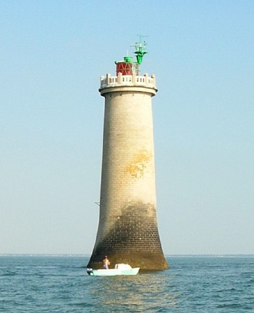
1888. Active; focal plane 22 m (72 ft); quick-flashing light, white, red, or green depending on direction. 26 m (89 ft) round granite tower with lantern and gallery, incorporating keeper's quarters. Tower is unpainted gray stone; lantern is red. Morez Pascal's photo is at right, Trabas has Capt. Peter's photo, Stéphane Legars has a 2021 photo, Werning has a distant view, Huelse has a historic postcard view, and Google has a satellite view. Located on a rocky shoal about 3 km (2 mi) southwest of Saint-Marc-sur-Mer. Accessible only by boat, but there are good views from shore. Site and tower closed. ARLHS FRA-014; FR-0855; Admiralty D1104; NGA 0944.
Phare du Grand Charpentier
Grand Charpentier Light, Saint-Marc-sur Mer, July 2006
ex-Panoramio photo copyright Morez Pascal; permission requested

Pornichet and Le Pouliguen Lighthouses
Pornichet
Date unknown. Active; focal plane 11 m (36 ft); white, red, or green light depending on direction, 2 s on, 2 s off. 10 m (33 ft) round concrete tower, painted white with a green band at the top. Werning has a photo, Wikimedia has Rémi Jouan's sunset photo, Trabas has Capt. Peter's photo, and Bing has a satellite view. Located at the end of the south breakwater at Pornichet. Site open, tower closed. ARLHS FRA-604; Admiralty D1102; NGA 0892.
Le Pouliguen Jetée Sud (2)
1957. Active; focal plane 13 m (43 ft); quick-flashing red light. 15 m (49 ft) rakish pylon in the shape of a yacht's mast, mounted on a small equipment room. Tower painted white; the small lantern is red; a French flag flies above the lantern. Trabas has a photo by Stephan Hix, Werning has a photo, a view from the base of the pier is available, Google has a street view, and Bing has a satellite view. Located at the end of the south breakwater of Le Pouliguen. Site open, tower closed. ARLHS FRA-741; Admiralty D1098; NGA 0884.
Les Petits Impairs
Date unknown. Active; focal plane 6 m (20 ft); three green flashes every 12 s. 8 m (26 ft) round stone tower, painted green, on a stone pier. Trabas has a closeup photo by Capt. Peter and Google has a distant satellite view. Located in the Baie de Pouliguen about 1.5 km (1 mi) southeast of Le Pouliguen. Accessible only by boat. ite open, tower closed. ARLHS FRA-394; Admiralty D1100; NGA 0888.
La Banche
1865. Active; focal plane 22 m (72 ft); two flashes every 6 s, white or red depending on direction. 30 m (98 ft) round granite tower with lantern and gallery, incorporating keeper's quarters. Lighthouse painted with black and white horizontal bands; lantern is white. Julien Cantin's photo is at right, Lightphotos.net has a closeup photo, Hervé Therry has a photo, Trabas has a distant view, Huelse has a historic postcard view, and Bing has an indistinct satellite view. Located on a rocky shelf about 8 km (5 mi) south of Le Pouliguen, marking the beginning of the approach to the Loire estuary, Saint-Nazaire, and Nantes. Accessible only by boat. Site and tower closed. ARLHS FRA-003; FR-0851; Admiralty D1096; NGA 0896.

Phare de la Banche, Loire Approach, July 2006
Wikimedia Creative Commons photo by Julien Cantin

Le Croisic and La Turballe Lighthouses
Plateau du Four (Four du Croisic)
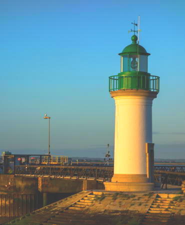
1822. Active; focal plane 23 m (75 ft); white flash every 5 s. 23 m (75 ft) round granite tower with lantern and gallery, incorporating keeper's quarters. Lighthouse painted in a black and white spiral pattern (unusual for France). The lighthouse was extended in height by 6.2 m (21 ft) in 1846. Arnaud Devorsine's photo is at the top of this page, Hervé Therry has a good photo, (also seen at right), a page for the lighthouse has a closeup photo, Trabas has a distant view, and Huelse has a historic postcard view, but the lighthouse is not shown in Google's satellite view. Not to be confused with the better-known Phare du Four (see the Northern Finistère page). Located on a rocky shelf, submerged at high tide, about 3 km (2 mi) west of the Pointe du Croisic, on the north side of the approach to the Loire. Accessible only by boat. Site and tower closed. ARLHS FRA-052; FR-0845; Admiralty D1080; NGA 0820.
* Le Croisic (Jetée de Tréhic)
1874. Active; focal plane 12 m (39 ft); white or green light depending on direction, 2 s on, 2 s off. 12 m (39 ft) round granite tower with lantern and gallery. The central portion of the tower is unpainted stone; circular base painted white; lantern and gallery painted green. A photo is at right, Werning has a photo, Trabas has Capt. Peter's closeup photo, another photo is available, Guyomard and Carceller have good photos, Huelse has a historic postcard view, Philippe Courpat has a street view, and Google has a satellite view. The tower was damaged during World War II; it was repaired and a new lantern installed at the end of the war. Located at the end of the 900 m (0.55 mi) breakwater on the west side of harbor entrance in Le Croisic. Accessible in good weather by walking the pier; as we see in the photo at right this is a popular walk. Site open, tower closed. . ARLHS FRA-519; Admiralty D1088; NGA 0860.
* La Turballe (Jetée de Garlahy) (1)
1894. Inactive since 1958. 9 m (30 ft) round cylindrical tower with gallery; lantern removed. Tower painted white. Guyomard and Carceller have an aerial photo, Werning has a good photo, and Google has a satellite view and a distant street view. Huelse has a historic postcard view of the original tower with its lantern but without the masonry equipment room that now surrounds the base of the tower. Trabas has Capt. Peter's photo of the active light, a sleek metal pylon painted white with a red top (focal plane 13 m (43 ft); four flashes, white or red depending on direction, every 12 s). Located on the breakwater sheltering the harbor of La Turballe. Site open, tower closed. ARLHS FRA-737. Active light: Admiralty D1076; NGA 0844.

Plateau du Four Light, Le Croisic, April 2015
Google Maps photo posted by Hervé Therry

Piriac-sur-Mer and Mesquer Lighthouses
* Piriac-sur-Mer (2)
1949 (station established 1906). Active; focal plane 8 m (27 ft); white, red, or green light, depending on direction, occulting twice every 6 s. 8 m (27 ft) semicircular concrete tower, painted white. Werning has a good photo (also seen at right), Trabas has Capt. Peter's closeup photo, Wikimedia has Rémi Jouan's closeup, Sebastian Moj has a street view, and Google has a satellite view. Located at the end of the Quai de Verdun at Piriac-sur-Mer. Site open, tower closed. ARLHS FRA-124; Admiralty D1074; NGA 0812.
[Île Dumet]
Date unknown (station established 1900). Active; focal plane 14 m (46 ft); three flashes every 12 s, white, red or green depending on direction. 6 m (20 ft) post standing beside a square fort. Trabas has a very distant view and Google has a distant satellite view. The Île Dumet is a small island about 6 km (3.5 mi) northwest of Piriac-sur-Mer. There are two ruined forts on the island; the one with the light was built in 1845. Located near the center of the island. Accessible only by boat. Site open, fort open. ARLHS FRA-094; Admiralty D1060; NGA 0784.
* Mesquer (Pointe de Merquel) (3)
Date unknown (station established 1920). Active; focal plane 7 m (23 ft); white, red, or green light, depending on direction, occulting once every 4 s. 7 m (23 ft) post attached to a 1-story equipment room. Trabas has Capt. Peter's photo, Christian Braut has a closeup street view, and Google has a satellite view. Fichou has a photo of the previous (1955) light, a semicircular concrete tower attached to a small equipment room. The original lighthouse was heavily damaged during World War II; after the war a temporary light was shone from atop the ruins. Located on the jetty at the Pointe de Merquel, the south side of the entrance to the Marais Salants estuary north of Mesquer. Site open, tower closed. ARLHS FRA-735; Admiralty D1072; NGA 0808.

Piriac-sur-Mer Light, Piriac-sur-Mer
photo copyright Malte Werning; used by permission

Information available on lost lighthouses:

Notable faux lighthouses:

Adjoining pages: North: Morbihan | South: La Vendée

Return to the Lighthouse Directory index | Ratings key

Posted October 25, 2005. Checked and revised September 2, 2023. Lighthouses: 28. Site copyright 2023 Russ Rowlett and the University of North Carolina at Chapel Hill.