Lighthouses of Northern Chile

On the southwest coast of South America the Republic of Chile has one of the world's longest and most dangerous coastlines, more than 4000 km (2500 mi) long with at least 5000 rocky islands. To guard this coast the Chilean Navy operated for many years one of the world's most active and most distinguished lighthouse services, the Chilean Maritime Signaling Service .

Chile's present northern border was not established until 1929. During the War of the Pacific (1879-1883) Chile conquered the Atacama region from Bolivia and occupied the Antofagasta, Iquique, Arica, and Tacna regions of Peru. The Chilean occupation of Tacna and Arica was the cause of an extended dispute between Chile and Peru. In the 1929 Treaty of Lima the disputed area was divided, with Tacna returning to Peru and Arica remaining in Chile. The Península Serrano lighthouse at Iquique, shown at right, was built by Peru before the start of the war.

Chile is divided into 16 regions (regiones) and the regions are subdivided into provinces (provincias). This page covers the five northernmost regions: Coquimbo, Atacama, Antofagasta, Iquique, and Arica.

Many of the historic lighthouses of Chile are the work of George Slight (1859-1934), a Scottish engineer who moved to Chile in the 1890s and eventually became the head of the Chilean Maritime Signaling Service. In all he designed and supervised the construction of more than 70 lighthouses.

The Spanish word for a lighthouse is faro. In Spain, the word faro is usually applied only to the larger coastal lights, but in South America it is often used for all fixed lights, including towers too small to be considered lighthouses. In Spanish isla is an island, cabo is a cape, punta is a promontory or point of land, péñon is a rock, arrecife is a reef, bahía is a bay, ría is an estuary or inlet, estrecho is a strait, río is a river, and puerto is a port or harbor. Also, the Spanish word canal means a natural channel, not an artificial canal.

Chile's lighthouse agency, the Servicio de Señalización Marítima, is now an office within the ministry known as Directemar (Dirección General del Territorio Marítimo y Marina Mercante).

ARLHS numbers are from the ARLHS World List of Lights. Admiralty numbers are from volume G of the Admiralty List of Lights & Fog Signals. U.S. NGA List numbers are from Publication 111. The Chilean light list, Lista de Faros de la Costa de Chile, is not available online.

General Sources
Faros de Chile
Index to articles in the Spanish language Wikipedia.
Faros Chilenos
Photos and information posted on the Argentine-based Faros del Mar web site.
Online List of Lights - Chile
Photos by various photographers posted by Alexander Trabas. Many of the photos are by Henrdik Martin Porath or Jim Smith.
Faros y Balizas de Chile
Flickr.com group pool, with more than 200 photos of Chilean lighthouses.
Lighthouses in Chile
Photos by various photographers available from Wikimedia.
World of Lighthouses - Chile
Photos by various photographers available from Lightphotos.net.
Lighthouses of Northern Chile
Five excellent photos contributed by Iván Vargas.
Leuchttürme Südamerikas auf historischen Postkarten
Historic postcard views posted by Klaus Huelse.
Navionics Charts
Navigation chart for Chile.

Faro Punta Serrano
Península Serrano Light, Iquique
photo by Servicio de Señalización Marítima

Coquimbo Region Lighthouses

Choapa Province Lighthouses
Isla Huevos (Los Vilos, Bahía de Conchalí) (2?)
Date unknown (station established 1901). Active; focal plane 19 m (62 ft); red flash every 10 s. 4 m (13 ft) round fiberglass tower colored red. Alejandro Cortés has a photo, Danielle Vandeperre has a photo, and Google has a satellite view. The original light was described as a white tower with a green lantern. The name means "Isle of Eggs," probably a reference to nesting seabirds. Located on a small island off the south side of Los Vilos, a fishing port and beach resort. Accessible only by boat. Site status unknown. Admiralty G1890; NGA 1216.
Punta de Tablas (Cabo Tablas)
Date unknown. Active; focal plane 72 m (236 ft); white flash every 10 s. 5 m (17 ft) round fiberglass tower colored white with one red horizontal band. Patricio Novoa has a distant view and Google has a distant satellite view. Located on a steep-sided rock at the tip of a cape about 13 km (8 mi) north of Los Vilos. Practically inaccessible but easily seen from a hiking trail on the mainland. Site status unknown. Admiralty G1892; NGA 1212.

Elqui Province Lighthouses
Punta Lengua de Vaca ("Cow Tongue Point") (2)
Date unknown (station established 1901). Active; focal plane 41 m (145 ft); white flash every 15 s. 4 m (13 ft) round fiberglass tower colored white with one red horizontal band. A closeup photo is available and Google has a satellite view. The original lighthouse was a 7 m (23 ft) round cast iron tower with lantern and gallery. Located on a very prominent cape at Tongoy, about 40 km (25 mi) southwest of Coquimbo. Site open (but not so easy to reach), tower closed. Admiralty G1896; NGA 1208.
* Puerto Aldea
Date unknown. Active; focal plane 7 m (23 ft); three white flashes every 9 s. 4.5 m (15 ft) round fiberglass tower colored white with one red horizontal band. Google has a distant street view and a distant satellite view. Located on the beach on the Bahía de Tongoy. Site open, tower closed. Admiralty G1896.3; NGA 1209.
* Punta Tortuga ("Turtle Point") (Coquimbo) (3?)
Date unknown (station established 1886). Active; focal plane 24 m (79 ft); white flash every 13 s. 4 m (13 ft) lantern, mounted on a square concrete foundation directly on the rocky point. Lantern painted red with a white roof. Trabas has Jim Smith's photo (also seen at right), Pablo González has a 2018 closeup photo, Juan Castro also has a closeup, and the tiny tower is centered in Google's satellite view. A stairway climbs over the rocks to reach the light. The original light was apparently replaced in 1898 by a "dark-colored tower," elsewhere described as wooden and in an English style. Punta Tortuga is the headland sheltering the bay of Coquimbo. Located beyond the end of Camino El Faro, about 3 km (2 mi) north northwest of downtown Coquimbo. Accessible by a short climb through rocks. Site open, tower closed. . ARLHS CHI-077; Admiralty G1900; NGA 1184.
 

Punta Tortuga Light, Coquimbo
photo copyright Jim Smith; used by permission
 
* Cruz del Tercer Milenio ("Cross of the Third Millennium")
2001. Active; focal plane 253 m (830 ft); white flash every 5 s. 93 m (305 ft) monumental concrete cross. Luis Espinoza has a 2022 photo, Wikimedia has numerous photos, Trabas has a photo by Douglas Cameron, and Bing has a satellite view. Built to mark the the turning of the Millennium and the beginning of the third millennium of Catholicism, this great engineering sculpture stands atop the Cerro El Vigia, the hill overlooking the harbor of Coquimbo. Site open, tower closed. . Admiralty G1899.
* Monumental La Serena
1951. Active; focal plane 28 m (92 ft); white flash every 5 s. 25 m (82 ft) cream-colored square concrete tower, rising from the center of a square 1-story building. Gallery red; lantern red with domed roof. Johan Fabry's photo is at right, Trabas has Jim Smith's closeup photo, José Francisco Carle Carrera has a good photo, Wikimedia has several photos, Juan Benavente has a fine drone view, and Google has a street view and a satellite view. The lighthouse was built as a landmark terminating the Avenida Francisco de Aguirre, which links the old city to the sea. The Navy conveyed ownership of the building to the city in 1996; the lighthouse is now used as a cultural center and meeting hall. Recent visitors found it in poor condition, but a March 2019 visitor reported it was "undergoing a long overdue restoration." In 2021 a $2.1 million project was completed restoring the building and protecting the lighthouse from sea level rise with a sea wall. An additional project will improve the surroundings for better access and recreation. Located directly on the beach in La Serena. Site open and tower open. Owner/site manager: Municipalidad de La Serena. . ARLHS CHI-002; Admiralty G1900.5; NGA 1176.
Islotes Pájaros ("Bird Islands") (2)
Date unknown (station established 1892). Active; focal plane 40 m (131 ft); two white flashes every 10 s. 4.5 m (15 ft) round fiberglass tower colored black with a red horizontal band. Bing has an indistinct satellite view. The original lighthouse was a 13.5 m (44 ft) cast iron tower with lantern and gallery. That lighthouse and its keeper's house have vanished. Located on the southernmost islet of a rocky reef about 35 km (22 mi) northwest of Coquimbo. Accessible only by boat. Site and tower closed (nature reserve). Admiralty G1904; NGA 1172.
Punta Mostacilla
Date unknown. Active; focal plane 38 m (125 ft); white flash every 5 s. 8 m (26 ft) round cylindrical fiberglass tower, painted white with one narrow red horizontal band. Mapio.net has a photo and Google has a street view and a satellite view. This light marks a small artificial harbor. Located on a promontory about 12 km (7.5 mi) northwest of La Higuera. Site status unknown. ARLHS-072; Admiralty G1908; NGA 1168.
La Serena Light
La Serena Light, La Serena, March 2009
ex-Flickr Creative Commons photo by Johan Fabry
 

Atacama Region Lighthouses

The Atacama Desert is famous as the driest nonpolar desert in the world, with most locations receiving only a few millimeters of rain per year on the average and a few where rain has never been recorded. However the region is rich in mineral resources and rivers flowing down from the Andes Mountains provide water for agriculture.

Huasco Province Lighthouses
Isla Chañaral (2)
Date unknown (station established 1897). Active; focal plane 58 m (190 ft); white flash every 12 s. 7.5 m (25 ft) round tower with gallery, painted with red and white bands. A closeup photo is available, Sea-seek.com has a view from the sea, and Google has a satellite view. The Isla Chañaral is the largest of the Islotes Atacama, located about 6 km (3.5 mi) offshore and about 65 km (40 mi) southwest of Huasco (not near the port of Chañaral). The site of the world's largest breeding colony of Humboldt penguins, the island is part of the Reserva Nacional Pingüino de Humboldt. Visitation is by permit only. Site and tower closed. ARLHS CHI-042; Admiralty G1916; NGA 1164.
Puerto Los Losas Range Common Front
Date unknown. Active; focal plane 30 m (98 ft); gren light, 1 s on, 1 s off. 19 m (62 ft) skeletal tower. No photo available but the shadow of the tower is seen in Bing's satellite view. Located in the industrial Guacolda harbor on the west side of Huasco. Site and tower closed. Admiralty G1918.6; NGA 1162.81.
Santa Barbara Range Common Front
Date unknown. Active; focal plane 40 m (131 ft); continuous green light. 14 m (46 ft) square skeletal tower. Google has a distant street view and Bing has a satellite view. Located near the east edge of the Guacolda harbor facilities on the west side of Huasco. Site and tower closed. Admiralty G1919.1; NGA 1163.
** Monumental de Huasco
1996. Active (?) (unofficial; maintained by the municipality; charted by Navionics as a landmark); focal plane about 25 m (82 ft); continuous (?) white light. 22 m (72 ft) octagonal concrete tower with lantern. Tower painted white but largely covered with artwork reflecting the history of the town; lantern dome is red. A photo and a 2022 photo are available, and Google has a street view and a satellite view. From 2004 to 2009 the tower was painted with red and white bands, as seen in a 2005 photo. The artwork was added in 2018. The lighthouse was built by the city as a tourist attraction. Located on the waterfront of Huasco. Site open, tower reported open for climbing but no details are available. Owner/site manager: Municipalidad de Huasco. .

Copiapó Province Lighthouse
* Punta Caldera (2)
1868. Active; focal plane 38 m (125 ft); white flash every 12 s. 18.5 m (61 ft) square wood tower with lantern and gallery, painted with red and white bands. Horacio Parrague's photo is at right, Trabas has Porath's excellent photo, Juan Esteban Mora Contreras has a closeup 2022 photo, Wikimedia has several photos, Iván Vargas has contributed a photo, Geraldo McCabe has a view from the sea, and Google has a satellite view and a distant street view. In Huelse's historic postcard view the lighthouse appears without the horizontal bands. Chile's only all-wooden lighthouse. The lighthouse was restored in 1947 and again in 1987. Located on a prominent cape about 5 km (3 mi) northwest of the waterfront of Caldera; the cape is accessible by road but it's a tough hike from the end of the road to the lighthouse. Site open, tower closed. . ARLHS CHI-065; Admiralty G1924; NGA 1148.

Punta Caldera Light, Caldera, August 2010
ex-Panoramio Creative Commons photo by Horacio Parrague

Chañaral Province Lighthouses
*** Monumental Chañaral (Faro del Milenio)
2000. Active (maintained by the municipality); focal plane 83 m (272 ft); white flash every 5 s. 15 m (49 ft) round metal (steel?) tower with lantern, mounted on a 1-story circular stone base. Trabas has Porath's photo, Wikimedia has two photos, Matthieu Gillot has a 2021 photo, Leon Calquin's photo shows the situation of the lighthouse, and Google has a street view and a satellite view. This lighthouse was built by the city of Chañaral as a Millennium project and tourist attraction. It was inaugurated 1 September 2000. The interior of the tower contains an exhibition space. Located on a steep hillside above Chañaral. Site open, tower believed to be open but we do not have schedule information. Owner/site manager: Municipalidad de Chañaral. . ARLHS CHI-090; Admiralty G1935.5; NGA 1141.
Punta Achurra
Date unknown. Active; focal plane 32 m (105 ft); white flash every 15 s. 8 m (26 ft) round fiberglass tower colored white with a red horizontal band. Trabas has Porath's photo, another photo is available and Google has a distant satellite view. Located on a promontory on the north side of the bay of Chañaral. Site open, tower closed. ARLHS CHI-062; Admiralty G1936; NGA 1130.

Antofagasta Region Lighthouses

Antofagasta is the largest city of northern Chile with a population of more than 400,000. It has an active port serving the mining industries of the Atacama area. The city was fomerly in Bolivia; it was captured by Chile in 1879, an event triggering the War of the Pacific (1879-83).

Antofagasta Province Lighthouses
[Caleta Caloso ("Warm Cove") (2)]
Date unknown. Active (privately maintained); focal plane 36 m (118 ft); three white flashes every 12 s. 20 m (66 ft) steel mast. Oscar Aranda has a street view and Google has a satellite view. The light guides vessels to a port that ships copper from a large mine in the desert 170 km (105 mi) southeast of Antofagasta. A public observation platform (mirador) provides a view of the port and the sea. NGA descibes a rectangular skeletal tower. Located on a promontory at Caloso, about 10 km (6 mi) south of Antofagasta. Site status unknown. Operator: Puerto Minera Escondida. Admiralty G1940; NGA 1127.
Antofagasta (Outer Breakwater, Extremo Molo de Abrigo)
1934. Active; focal plane 18 m (59 ft); white flash every 5 s. 14 m (43 ft) octagonal concrete tower with lantern and gallery, painted with red and white horizontal bands. Felipe Ascencio's photo appears at right, Bernardo Améstica has a photo, Iván Vargas has contributed an older photo in which lighthouse is painted all red, Martin Mella has a view from the sea, and Google has a satellite view and a street view from the Molo Este. Located on the end of the main (south) breakwater at Antofagasta. Site status unknown. . ARLHS CHI-058; Admiralty G1946; NGA 1124.
Antofagasta Molo Este
Date unknown. Active; focal plane 6 m (20 ft); green flash every 5 s. 5 m (17 ft) round dark green fiberglass tower with a pramidal base. Wikimedia has a photo by Juan Pablo Arenas Godoy, and Google has a satellite view and a closeup street view. Located at the end of the east (really the north) mole of Antofagasta's modern harbor. Site status unknown. Admiralty G1947; NGA 1120.
Punta Tetas
Date unknown. Active; focal plane 33 m (108 ft); white flash every 18 s. 8 m (26 ft) round fiberglass tower, painted white with one narrow red horizontal band. A closeup photo is available and Google has a satellite view. This site would be a long walk from the nearest road. Located on the cape at the northern entrance to the Bahía de Antofagasta. Site status unknown. ARLHS CHI-075; Admiralty G1948; NGA 1112.
* Punta Angamos (2?)
Date unknown. Active; focal plane 109 m (358 ft); white flash every 10 s. 8 m (26 ft) slender round fiberglass tower, colored white with one red horizontal band. Erasmo Rivera has a closeup photo, a 2017 photo is available, and Google has a satellite view. Iván Vargas has contributed a photo of a light similar to the Punta Gruesa Light (see below); this light apparently does not survive. A nearby viewpoint is a popular tourist attraction. The headland of Punta Angamos projects into the Pacific northwestward, sheltering the Bahía Mejillones. Site open, tower closed. ARLHS CHI-096; Admiralty G1952; NGA 1108.
* Puerto Mejillones del Sur
Date unknown. Active; focal plane 20 m (66 ft); green flash every 3 s. The light was mounted originally on the balcony of the square tower of the harbormaster's office, a 2-story 19th century building painted white with red trim. Google's street view suggests that the light has been moved to a skeletal tower on the roof of the building. Ricardo Fernandez has a 2017 photo, Oscar Aranda has a closeup street view, and Google has a satellite view. Mejillones del Sur is a small town facing north onto a broad bay about 60 km (37.5 mi) north of Antofagasta. Located on the beach. Site open, building presumably open, tower status unknown. Admiralty G1953; NGA 1098.
Antofagasta Light
Extremo Molo de Abrigo Light, Antofagasta, December 2007
Flickr Creative Commons photo by Felipe Ascencio

Tocopilla Province Lighthouse
Punta Algodonales (Islote Blanco)
Date unknown. Active; focal plane 24 m (79 ft); white flash every 12 s. 8 m (26 ft) round fiberglass tower colored white with a red horizontal band. Trabas has Hendrik Martin Porath's photo and Google has a distant satellite view and a very distant street view. The light guides vessels to an industrial port shipping saltpeter. Located on an islet just off the port on the southwest side of Tocopilla. Accessible only by boat. Site and tower closed. Admiralty G1956; NGA 1096.

Tarapacá Region Lighthouses

Iquique Province Lighthouses
The provincial and regional capital of Iquique is a city of about 200,000 residents. The city was in Perú until it was captured by Chile in 1879, during the War of the Pacific

Punta Patillos
Date unknown. Active; focal plane 41 m (135 ft); white flash every 5 s. 4 m (13 ft) round fiberglass tower colored white with a red horizontal band. Trabas has a photo by Capt. Theo Hinrichs and Google has an indistinct satellite view. The light guides vessels to an industrial port shipping salt. Located about 50 km (30 mi) south of Iquique. Site and tower closed. Admiralty G1963; NGA 1076.
* Punta Gruesa (Iquique)
Date unknown (station established 1947). Active; focal plane 27 m (89 ft); white flash every 10 s. 10 m (33 ft) pyramidal concrete tower atop a 1-story equipment room; light displayed from a small lantern on the front face of the tower. Iván Vargas has contributed a photo, Sea-seek.com has two photos, and Google has a street view and a satellite view. The light is a memorial to Chilean seamen lost in the Battle of Iquique and its continuation, the Battle of Punta Gruesa, on 21 May 1879. Located on a headland about 15 km (10 mi) south of Iquique; accessible by an unpaved road off the A630 highway. Site open, tower closed. Admiralty G1964; NGA 1072.
Península Serrano
1878 (Barbier et Fenestre). Reactivated (inactive 1946-1995); focal plane 39 m (128 ft); white flash every 12 s. 22 m (72 ft) slender cylindrical cast iron tower with four skeletal legs, painted with red and white bands (lantern red). A Navy photo appears at the top of this page, Lightphotos.net has a good photo, Trabas has Porath's photo, Google has a street view, and the tower is centered in a Google satellite view. This lighthouse was built by the French firm Barbier et Fenestre for the government of Peru, which controlled the Iquique area at the time. The lighthouse was placed in operation in time to witness the naval Battle of Iquique in May 1879; later that year the city was conquered by Chilean forces. Declared a National Monument in 1986, this lighthouse is a rare surviving example of French lighthouse design. The lighthouse was carefully restored and reactivated in 1993-95. Located on the Serrano Peninsula on the south side of the Bay of Iquique. The lighthouse is in the middle of the commerical port of Iquique, and the absence of photos proves that this area is not open to the public. Site open, tower closed. ARLHS CHI-095; Admiralty G1974.3; NGA 1050.
Iquique (Molo de Abrigo, Outer Breakwater) (2)
1932 (station established 1903). Active; focal plane 19 m (62 ft); red flash every 10 s. 13.5 m (44 ft) octagonal masonry tower with lantern and gallery. Entire lighthouse painted red. A photo by Denise Ruiz-Aburto Aguilar is at right, Eric De Pablo has a 2009 photo, Wikimedia has photos, Trabas has a view from the sea by Capt. Theo Hinrichs, and Google has a street view and a satellite view. Located at the end of the west breakwater at Iquique, which projects from the north side of the Península Serrano. Site and tower closed. ARLHS CHI-082; Admiralty G1968; NGA 1036.

Outer Breakwate Light, Iquique, March 2011
Flickr Creative Commons photo by Denise Ruiz-Aburto Aguilar

Arica y Parinacota Region Lighthouses

Arica Province Lighthouses
Chile's northernmost city, Arica is located at the "hinge" of South America's west coast, where the north-south coast of Chile meets the northwest-southeast coast of Perú. Arica is the main port for landlocked Bolivia's international trade and it is also the terminal for an oil pipeline from Bolivia. Captured by Chile from Perú in 1880, during the War of the Pacific, Arica has a population of about 225,000.

* Península Alacrán (Isla Alacrán, "Scorpion Point") (2)
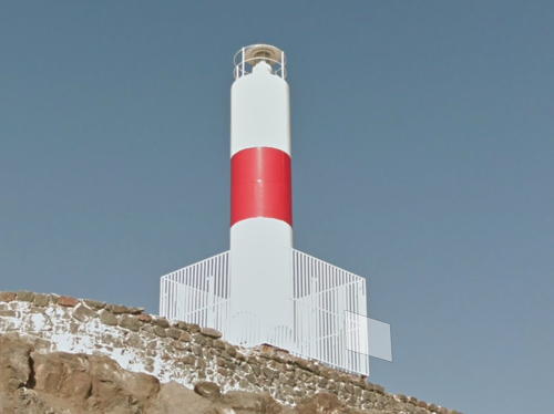
Date unknown (station established 1913). Active; focal plane 23 m (75 ft); white flash every 15 s. 8 m (26 ft) round fiberglass tower, painted white with a red band. The Isla Alacrán is a small island just off the coast, now joined to shore by a causeway. Kuba Jurkowski has a closeup photo, Trabas has a closeup by Porath, Dany Valcarce has another closeup, and Google has a street view (a portion is seen at right) and a satellite view. Located between the commercial and small boat harbors at Arica. Site open, tower closed. ARLHS CHI-061; Admiralty G1984; NGA 1012.
Arica South Breakwater
Date unknown. Active; focal plane 20 m (66 ft); red flash every 5 s. 12 m (39 ft) concrete post with an enclosed concrete lantern, painted red. Trabas has a closeup by Jim Smith, Mapio.net has a photo, and Google has a satellite view. Located at the end of the breakwater. Site and tower closed. ARLHS CHI-059; Admiralty G1986; NGA 1020.
* Limitrofe (Concordia Range Rear)
1972. Active; focal plane 42 m (138 ft); green flash every 5 s. 22 m (72 ft) square pyramidal steel skeletal tower, all four sides covered with slats painted in red and white bands; light displayed from atop a small square equipment room at the top of the tower. Iván Vargas has contributed a photo, a 2022 closeup is available, and Google has a satellite view. Keeper's house staffed. This light was formerly the rear light of a range. The front light, across the border in Peru, was demolished after being heavily damaged by an earthquake. Located at the Peruvian border about 30 km (19 mi) north of Arica. Site open, tower closed. ARLHS CHI-101; Admiralty G1987; NGA 1008.
 

Península Alacrán Light, Arica, June 2012
Google Maps street view
 

Information available on lost lighthouses:

Notable faux lighthouses:

Adjoining pages: North: Southern Perú | Northeast: Bolivia | South: Central Chile

Return to the Lighthouse Directory index | Ratings key

Posted December 2004. Checked and revised August 21, 2023. Lighthouses: 28. Site copyright 2023 Russ Rowlett and the University of North Carolina at Chapel Hill.