Lighthouses of China: Shànwěi Area, Guǎngdōng

The People's Republic of China (PRC), known officially as Zhōnghuá (中华), has a lengthy coastline, many large harbors, and a large number of lighthouses. The country is divided into 23 provinces and 11 other province-level regions of various special types. The province of Guǎngdōng (formerly spelled Kwangtung) is located on the southern coast of the country facing the South China Sea. The coastline is rugged and irregular, with many islands and reefs threatening unwary navigators.

The province is divided into 21 prefectural-level cities. This page lists lighthouses of the eastern portion of the province, immediately to the east of Hong Kong, in the prefectural-level cities of Jiēyáng, Shànwěi, and Huìzhōu.

Lighthouses in China are maintained by the PRC Maritime Safety Administration. The administration is organized in four regional administrations with district offices in the major ports. All the lights on this page are maintained by the MSA Maritime Security Center Shàntóu, which is part of the Guǎngzhōu Region.

There are many languages and dialects spoken in China, but Standard Chinese, often called Mandarin, is official. The pīnyīn system for transliterating Standard Chinese into Latin characters is now the international standard but some locations continue to be known also under the spellings of older transliteration systems. The Chinese word for a lighthouse is dēngtǎ (灯塔). In Standard Chinese jiāo (formerly chiao) is a reef or rock, jiǎo is a cape or headland, dǎo (tao) is an island; (tsu) or tuózi ("lump") is a small island, hǎi is a sea, wān is a bay, hǎixiá is a strait, or jiāng is a river, hékǒu ("river mouth") is an estuary, and gǎng (kang) is a harbor.

ARLHS numbers are from the ARLHS World List of Lights. CN numbers are the MSA List of Lights (助航标志表) numbers. Admiralty numbers are from volume P of the Admiralty List of Lights & Fog Signals. U.S. NGA List numbers are from Publication 112.

General Sources
Online List of Lights - China
Photos by various photographers posted by Alexander Trabas.
Chinese English Pinyin Dictionary
A useful tool for juggling the representations of Chinese names.
Navionics Charts
Navigation chart for the Shànwěi area.

Tianweijiao Light
Tiánwěijiǎo Light, Shànwěi
PRC Maritime Security Center Shàntóu photo
Jiēyáng Prefecture Lighthouses

The prefectural level city of Jiēyáng has a population approaching 6 million. Most of the city is inland north and west of Shàntóu, but it includes a relatively short coastline in Huìlái County.

Huìlái County Lighthouses
Nánpàotái
Date unknown. Active; focal plane 21 m (69 ft), white flash every 6 s. 7 m (23 ft) square cylindrical concrete tower. A very distant view is available and Google has a satellite view. Located on a sharp promontory in the town of Zīshēn about 4 km (2.5 mi) north of the Shíbēishān lighthouse. Site status unknown. CN-4067; Admiralty P3586.5.
Yǔzǐtóujiāo
Date unknown. Active; focal plane 14 m (46 ft), white flash every 4 s. 5 m (17 ft) white stone tower. No photo available but Bing has a satellite view. Located on a rocky reef about 500 m (0.3 mi) east southeast of the Nánpàotái light. Accessible only by boat. Site status unknown. CN-4066; Admiralty P3586.55.
* Shíbēishān (Stone Mountain, Breaker Point) (3)
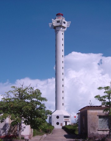
1990 (station established 1880). Active; focal plane 68 m (223 ft); white flash every 15 s. 59 m (195 ft) round cylindrical concrete tower with lantern and a hexagonal observation room, centered on a 2-story hexagonal control building. This is a staffed station. Lighthouse painted white, lantern red. A Guǎngdōng MSA Office photo is at right and Google has a satellite view. This soaring tower is the third tallest Chinese lighthouse (after Mùlán Tóu and Báishā Mén on the island of Hǎinán) and one of the best known lighthouses of South China. Jìnghǎijiǎo (Cape Jìnghǎi) is not very high, but it is the point where the trend of the coastline changes from mostly east-west to northeast-southwest. The original lighthouse, a 37 m (121 ft) cast iron tower, was destroyed during World War II. It was replaced in 1948 by a 34 m (111 ft) cast iron tower. Located on Cape Jìnghǎi, about 25 km (15 mi) southeast of Huìlái. Accessible by road. Site probably open, tower closed. CN-4073; Admiralty P3586; NGA 19264.
Yuèdōng LNG Range Front
Date unknown. Active; focal plane 43 m (141 ft); red flash every 3 s. 31.5 m (103 ft) square skeletal tower. No photo available but Google has a satellite view. This is an approach range for a large new LNG terminal. Located on the west side of the terminal, about 5 km (3 mi) southeast of Shénquán. Site and tower closed. CN serial 7111381; Admiralty P3585.85.
Yuèdōng LNG Range Rear
Date unknown. Active; focal plane 57.5 m (189 ft); continuous red light. 43.5 m (143 ft) square skeletal tower. No photo available but Bing has a satellite view. Located about 400 m (1/4 mi) due north of the front light. Site and tower closed. CN serial 7111382; Admiralty P3585.851.
Shibeishan Light
Shíbēishān Light, Huìlái
PRC MSA Guǎngdōng Region photo

Shànwěi Prefecture Lighthouses

The prefectural-level city of Shànwěi has a population of about 3 million. More than half live in Lùfēng, a county-level city stretching east from the original port of Shànwěi.

Lùfēng City Lighthouses
Jiǎzǐjiǎo (Jiǎzǐ Jiǎo, Kupchi Point) (2)
2000 (station established 1955). Active; focal plane 78 m (256 ft); white flash every 10 s. 17 m (56 ft) round cylindrical concrete tower with lantern and gallery. Lighthouse painted white, lantern red. A photo is at right and Google has a good satellite view. The original light was on an 8 m (26 ft) square cylindrical brick tower rising from a square 1-story keeper's house. Located on a prominent cape about 8 km (5 mi) southwest of Jiǎzǐ. Accessible by road. Site possibly open, tower closed. CN-4075; Admiralty P3585; NGA 19272.
Tiánwěijiǎo (Tiánwěi Jiǎo, Tien-wei Chiao) (4?)
Date unknown (station established 1955). Active; focal plane 83 m (272 ft); three white flashes every 9 s. 6 m (20 ft) round cylindrical concrete tower with lantern and gallery. Lighthouse covered with ceramic tiles colored white with narrow red horizontal bands; the lantern is red. A photo is at the top of this page and Google has a satellite view. This light marks the eastern entrance to a semicircular bay, Jiéshí Wān. Located on a high promontory about 10 km (6 mi) south of Jiéshí. Accessible by road. Site possibly open, tower closed. CN-4078; Admiralty P3584; NGA 19276.
Wūkǎn Gǎng East Breakwater
Date unknown. Active; focal plane about 13 m (43 ft); green flash every 4 s . Approx. 10 m (33 ft) round cylindrical concrete tower. No photo available but Bing has a satellite view. Located on the east breakwater of a dredged cut that has replaced the mouth of the Wūkǎn River, on the north coast of Jiéshí Wān. Site status unknown. CN-4078.42; Admiralty P3583.62.
Wūkǎn Gǎng West Breakwater
Date unknown. Active; focal plane about 13 m (43 ft); red flash every 4 s. Approx. 10 m (33 ft) round cylindrical concrete tower. No photo available but Bing has a satellite view. Located on the west breakwater of a dredged cut that has replaced the mouth of the Wūkǎn River. Site status unknown. CN-4078.41; Admiralty P3583.6.
 

Jiǎzǐjiǎo Light, Shànwěi
unattributed photo from thepaper.cn

Chéng Qū ("City District") Lighthouses
This district surrounds the original port and urban core of Shànwěi.
Zhēlàng (Zhēlàng Jiao, Che-lang Piao) (2?)
Date unknown (station established 1911). Inactive since 2007. 6 m (20 ft) round cylindrical concrete tower with gallery and a small lantern, mounted on a round stone base. Lighthouse painted white; the stone base is unpainted. This light is seen next to the new lighthouse in the photo at right.
Zhēlàng (Zhēlàng Yán, Che-lang Piao) (3?)
2007 (station established 1911). Active; focal plane 63 m (207 ft); white flash every 5 s. 30 m (98 ft) round cylindrical concrete tower with lantern and gallery. Lighthouse covered with white ceramic tiles; lantern painted red. Former keeper's houses and other station buildings in ruins. 2018 photo is at right, an MSA photo is available, and Google has a satellite view of the station. This light marks the western entrance to Jiéshí Wān. Curiously, both the Admiralty and NGA continue to describe the old tower. Located on an island off a sharp promontory at the eastern end of Shànwěi City. Accessible only by boat. Site status unknown. CN-4080; Admiralty P3582; NGA 19280.
Zhǔgànyǔ
2017(?). Active; focal plane 31 m (102 ft); two white flashes every 6 s. Approx. 22 m (72 ft) round cylindrical concrete tower with lantern and gallery colored with red and white horizontal bands. The Admiralty announced this light with a tower height of 10 m (33 ft) but it appears much taller in Google's satellite view. No photo available. Located on a small island about 10 km (6 mi) west southwest of the Zhēlàng lighthouse. Accessible only by boat. Site status unknown. CN-4080.55; Admiralty P3581.7.
Shànwěi Gang Range Front
Date unknown. Active; focal plane about 15 m (49 ft); white light occulting once every 3 s. Approx. 12 m (39 ft) square cylindrical skeletal tower. As daymarks the tower carries an orange vertical stripe and an orange triangle, point up. No photo available but Google has a satellite view. This is an entrance range for Shànwěi. Located in the waterfront area. Site and tower closed. CN-4084.1; Admiralty P3581.5.
Shànwěi Gang Range Rear
Date unknown. Active; focal plane 20 m (66 ft); white light occulting once every 3 s. 18 m (59 ft) square cylindrical skeletal tower. As daymarks the tower carries an orange vertical stripe and an orange triangle, point down. No photo available but Google has an indistinct satellite view. Located about 150 m (500 ft) southeast of the front light. Site and tower closed. CN-4084.2; Admiralty P3581.51.

Zhēlàng Light, Shànwěi, September 2018
Google Maps photo by Sunny Wu
Shànwěi Pier Range Front
Date unknown. Active; focal plane 15 m (49 ft); white light, 2 s on, 1 s off. 13 m (43 ft) square skeletal tower. No photo available but Google has a satellite view. Located on one of the main piers at Shànwěi. Site and tower closed. CN-4081.1; Admiralty P3581.35; NGA 19286.
Shànwěi Pier Range Rear
Date unknown. Active; focal plane 21 m (69 ft); white light, 2 s on, 1 s off (?). Approx. 15 m (49 ft) tower. No photo available but Google has a satellite view. Located about 250 m (280 yd) northeast of the front light, in trees behind the pier area. Site status unknown. CN-4083; Admiralty P3581.41.
Shànwěi (Sandianjin)
Date unknown. Active; focal plane 10 m (33 ft); white flash every 6 s. 10 m (33 ft) round cylindrical concrete tower. Entire lighthouse is white. No photo available but Google has a satellite view. Located off the entrance to Shànwěi. Accessible only by boat. Site open, tower closed. CN-4081; Admiralty P3581.345; NGA 19284.
Niúbítou (Bull Head, Mǎgōng)
Date unknown. Active; focal plane 117 m (384 ft); continuous white light. 5 m (17 ft) round white concrete tower. No photo available but Google has a satellite view. Located atop a steep headland on the east side of the entrance to Mǎgōng harbor on the west side of Shànwěi. Site status unknown. CN-4084.4; Admiralty P3581.32.
Māyìnjiāo
Date unknown. Active; focal plane 6.5 m (21 ft); two white flashes every 5 s. 9 m (30 ft) concrete tower painted black with one red horizontal band. In Bing's satellite view it appears the tower has been replaced or extended by a skeletal tower. No photo available. Located on a shoal in Mǎgōng harbor. Aceesible only by boat but there's a view from shore. Site open, tower closed. CN-4084.41; Admiralty P3581.321.

Huìzhōu Prefecture Lighthouses

Located on the east side of Hong Kong, the prefectural-level city of Huìzhōu has a population of about 4.6 million. Most of the city is inland but it has a coastline on Daya Bay.

Huìdōng County Lighthouse
Xīhǔyǔ (West Tiger Islet)
Date unknown. Active; focal plane unknown; white flash every 4 s. 5.5 m (18 ft) white concrete tower. No photo available but Google has a satellite view. Located on a forested island about 24 km (15 mi) northeast of Dàxīngshān. Accessible only by boat. Site status unknown. CN-4085.1; Admiralty P3581.299.
Dàxīngshān (Ta Shing Shan, Big Star Mountain, Fuji Jiao, Fokai Point) (2)
1996 (station established 1955). Active; focal plane 219 m (718 ft); white flash every 13 s. 24.5 m (80 ft) round cylindrical concrete tower with lantern, a large round observation room, and six ribs, attached to a 2-story control building. Lighthouse covered with white ceramic tiles; lantern painted red. A photo is at right, Guǎngdōng MSA's photo is also available, and Google has a satellite view. This lighthouse stands on a high promontory at the eastern end of Dàyà Bay, about 80 km (50 mi) east northeast of Hong Kong. Located about 12 km (7.5 mi) southeast of Pínghǎi. Accessible by road. Site possibly open, tower closed. CN-4085.2; Admiralty P3581.298; NGA 19288.
Tiēzchén Jiāo
Date unknown. Active; focal plane 15 m (49 ft); white flash every 5 s. 9 m (30 ft) round white concrete tower. No photo available but the shadow of the tower is seen in Bing's satellite view. Located on a reef about 1.2 km (3/4 mi) west of the southwestern tip of the Dàxīngshān peninsula. Accessible only by boat. Site status unknown. CN-4086; Admiralty P3581.284; NGA 19288.5.
Yuánzhōudǎo (Round Island)
Date unknown. Active; focal plane 22 m (72 ft); white flash every 4 s. 5.5 m (18 ft) round white concrete tower. The top of the tower is seen in a street view by Ben Hollis and Google has a satellite view. Located on a forested island about 2 km (1.25 mi) north of Tiēzchén Jiāo. Accessible only by boat. Site status unknown. CN-4085.8; Admiralty P3581.282.
Sāng Zhōu (Dàyà Wān)
Date unknown. Active; focal plane 65 m (213 ft); one long white flash every 8 s. 23 m (76 ft) white concrete tower. No photo available but Google has a satellite view. Located on an island in the east side of the entrance to Dàyà Bay (Dàyà Wān). Accessible only by boat. Site status unknown. CN-4085.31; Admiralty P3581.218; NGA 19289.

Huìyáng County (Daya Bay) Lighthouse
Mǎbiān Zhōu Range Front
Date unknown. Active; focal plane 33 m (108 ft); white light, 2 s on, 4 s off. 34 m (112 ft) round cylindrical concrete tower with lantern and gallery, mounted on a square concrete pier. No photo available but Google has a satellite view. This is the entrance range for Dàyà Bay. Located in Dàyà Bay about 2.2 km (1.4 mi) south of the rear light (next entry). Accessible only by boat. Site status unknown. CN-4085.55; Admiralty P3581.27.
Mǎbiān Zhōu Range Rear
Date unknown. Active; focal plane 59 m (194 ft); white light, 3 s on, 3 s off. 57 m (187 ft) round cylindrical concrete tower with lantern and gallery. No photo available but Google has a satellite view. Located on an islet near the center of Dàyà Bay. Accessible only by boat. Site status unknown. CN-4085.56; Admiralty P3581.271.

Dàxīngshān Light, Huìzhōu, November 2009
Google Maps photo by Jiàn Mù
Běiyán (North Rock, Apo Pai)
Date unknown. Active; focal plane 12 m (39 ft); white flash every 10 s. 13 m (43 ft) hexagonal stone tower, painted yellow. No photo available but Google has a satellite view. Located on a shoal off Huìzhōu harbor. Accessible only by boat. Site open, tower closed. CN-4086.64; Admiralty P3581.242.
Dōnglián Range Front
Date unknown. Active; focal plane 27 m (89 ft); white light, 2.5 s on, 2.5 s off. 27 m (39 ft) triangular white concrete tower carrying a red triangular daymark. No photo available but Google has a satellite view. Located just off the waterfront of the Dōnglián industrial harbor at the north end of Daya Bay. Accessible only by boat. Site and tower closed. CN-4086.55; Admiralty P3581.275.
Dōnglián Range Rear
Date unknown. Active; focal plane 50 m (164 ft); white light, 2.5 s on, 2.5 s off. Approx. 45 m (148 ft) triangular white concrete tower carrying a red triangular daymark. No photo available but Google has a satellite view. Located in the industrial area about 1.25 km (0.8 mi) northwest of the front light. Site and tower closed. CN-4086.56; Admiralty P3581.276.
Huìzhōu Gǎng Range Front
Date unknown. Active; focal plane 43 m (141 ft); continuous white light. Light mounted on an office building. No photo available but Google has a satellite view. Located on the waterfront of Huìzhōu harbor. Site and tower closed. CN-4088.1; Admiralty P3581.244.
Huìzhōu Gǎng Range Rear
Date unknown. Active; focal plane 60.5 m (198 ft); continuous white light. 31.5 m (103 ft) concrete tower; there appears to be a vertical stripe facing the range line. No photo available but Google has a satellite view. Located about 1.5 km (1 mi) northwest of the front light, adjacent to a major road. Site and tower closed, butvthe lighthouse would be easy to see from nearby. CN-4088.2; Admiralty P3581.245.
Dàngménpái
Date unknown. Active; focal plane 5 m (17 ft); red flash every 4 s. 7 m (23 ft) round concrete tower with gallery, covered with red tiles. A photo is available and Google has a satellite view. Located on a shoal in Áotóu harbor. Accessible only by boat. Site open, tower closed. CN-4088.3; Admiralty P3581.248.
Sùpái (Hutoumen Shuido)
Date unknown. Active; focal plane 9 m (30 ft); two white flashes every 5 s. 10 m (33 ft) round cylindrical concrete tower covered with tiles colored black with two red horizontal bands. No photo available but Google has a fuzzy satellite view. This light and the next one are on opposite sides of the channel to Huìzhōu harbor. Located on a shoal off Hùtóu Zui. Accessible only by boat. Site open, tower closed. CN-4087.2; Admiralty P3581.236.
Hùtóuzuǐ (Hùtóu Zuǐ, Tigerhead Point)
2008. Active; focal plane 18 m (59 ft); white flash every 5 s. 12 m (39 ft) hexagonal cylindrical concrete tower with lantern and gallery. Lighthouse is white, lantern roof red. A photo is at right, Kakama Amu has a 2018 photo, and Google has a satellite view. Located on a promontory on the west side of Dàyà Bay. Site open, tower closed. CN-4087.1; Admiralty P3581.234.

Hùtóuzuǐ Light, Huìzhōu, September 2010
Google Maps photo by cs sun
Xiǎochìzhōu (Xiǎochì Zhōu, Little Red Island) (2)
1988 (station established 1955). Active; focal plane 44 m (144 ft); white flash every 8 s. 8 m (26 ft) round concrete tower with gallery, painted white; the gallery rail is red. Lǐngnán Làngrén has a view from the sea, a 2021 drone view is available, and Google has a satellite view. Located on a small island near the center of Dàyà Bay. Accessible only by boat. Site status unknown. CN-4087; Admiralty P3581.228; NGA 19289.5.
Yuán Zhōu
2009. Active; focal plane 13 m (43 ft); white flash every 2 s. 10 m (33 ft) square white concrete tower with gallery. A distant 2021 drone view ia avilable and Google has a satellite view. Located on a reef about 4 km (2.5 mi) southeast of Hùtóuzuǐ. Accessible only by boat. Site open, tower closed. CN-4087.92; Admiralty P3581.23.
Bǎitóu Zhōu
2008. Active; focal plane 15 m (49 ft); three white flashes every 8 s. 10 m (33 ft) square white concrete tower with gallery. No photo available but Google has a satellite view. This light and the next one are on opposite sides of the channel to Huìzhōu harbor. Located at the east end of a small island about 5 km (3 mi) southeast of Hùtóuzuǐ. Accessible only by boat. Site open, tower closed. CN-4087.94; Admiralty P3581.224.
Xiǎolājiā
2008. Active; focal plane 16 m (52 ft); two white flashes every 8 s. 10 m (33 ft) round cylindrical white concrete tower with gallery. No photo available but Google has a satellite view. Located at the east end of a small island about 5 km (3 mi) southeast of Hùtóuzuǐ. Accessible only by boat. Site open, tower closed. CN-4087.95; Admiralty P3581.222.
Dàshuāng Zhōu
2008. Active; focal plane 36 m (118 ft); white flash every 8 s. 10 m (33 ft) round cylindrical white concrete tower with gallery. No photo available but Google has a satellite view. Located on a small island in the entrance to Dàyà Bay. Accessible only by boat. Site open, tower closed. CN-4087.955; Admiralty P3581.22.
Qīngzhōu (Qīng Zhōu, Ching Chou) (2)
1997 (station established 1989). Active; focal plane 107.5 m (352 ft); white flash every 6 s. 19.5 m (64 ft) round cylindrical concrete tower with lantern and gallery. Lighthouse covered with white ceramic tiles; lantern painted red. An MSA photo is at right, another photo is available, and Google has a satellite view. Qīngzhōu is a small island on the eastern approach to Hong Kong, about 50 km (30 mi) east of the city. Located on the highest point of the island. Accessible only by boat. Site status unknown. CN-4089.4; Admiralty P3580.98; NGA 19290.
Qingzhou Light
Qīngzhōu Light, Huìzhōu
PRC Maritime Safety Administration photo

Information available on lost lighthouses:

Notable faux lighthouses:

Adjoining pages: East: Shàntóu Area | West: Hong Kong

Return to the Lighthouse Directory index | Ratings key

Posted October 8, 2008. Checked and revised March 5, 2024. Lighthouses: 40. Site copyright 2024 Russ Rowlett and the University of North Carolina at Chapel Hill.