Lighthouses of Djibouti

The Republic of Djibouti is a small nation at the head of the Gulf of Aden in northeastern Africa. It was formerly a French colony known as French Somaliland (1884-1967) and then as the Territory of the Afars and Issas (1967-1977). It became independent in 1977. The country has maintained ties with France and has established ties with the U.S., making it possible for western tourists to visit the area.

Djibouti's territory surrounds the Gulf of Tadjoura, an inlet (or firth) of the Gulf of Aden about 65 km (40 mi) long and 25 km (15 mi) wide at its entrance. The gulf is quite deep because it is a drowned rift valley opened by the separation of the Indian and African Plates of the earth's surface.

The great lighthouse of Ra's Bir is the one fairly well known Djiboutian light. Very little is known about the others so photos and visitor reports are badly needed. Special thanks to Jean-François Rodriguez-Nadal for contributing two of the photos on this page.

French and Arabic are the official languages in Djibouti. In French the word for a lighthouse is phare; île is an island, banc is a shoal, passe is a strait or inlet, and havre is a harbor. The Arabic word for a lighthouse is mnarh or manara (منارة). Ra's is a cape, jaza'ir or jazirat is an island, and shi'b is a reef. Transliteration of Arabic to Latin characters can be done in many ways, so alternate spellings are common.

Aids to navigation in Djibouti are operated and maintained by the port authority, the Port of Djibouti. The port is operated under lease by Dubai Ports International. DPI is developing Djibouti as the major port of entry and export for northeastern Africa.

ARLHS numbers are from the ARLHS World List of Lights. Admiralty numbers are from volume D of the Admiralty List of Lights & Fog Signals. U.S. NGA List numbers are from Publication 112.

General Sources
Phares d'Afrique
Photos posted by Alain Guyomard and Robert Carceller as part of their Phares du Monde web site.
World of Lighthouses - Djibouti
Photos by various photographers available from Lightphotos.net.
Online List of Lights - Djibouti
Photos by various photographers posted by Alexander Trabas.
Afrikanischen Leuchttürme auf historischen Postkarten
Historic postcard images posted by Klaus Huelse.
Lighthouses of Africa
Historic postcard images posted by Michel Forand.
Navionics Charts
Navigation chart for Djibouti.

Ra's Bir Light
Ra's Bir Light, Obock, November 2011
photo copyright Jean-François Rodriguez-Nadal
used by permission

Obock Region Lighthouses
The village of Obock, on the north shore of the Gulf of Tadjoura, was the site of France's first colony in Djibouti (1862). The town has a population of 21,000.

Ra's Bir (1)
1889. Inactive as a lighthouse since 1952. 2-story square stone tower. In 2002-03 French contractors helped Djibouti install radars atop the old lighthouse to monitor ship traffic in the Bab-el-Mendab strait joining the Gulf of Aden to the Red Sea. Google has a satellite view. Located on Ra's Bir, a desolate cape at the northern entrance to the Gulf of Tadjoura. Accessible by boat or by 4WD from Obock, but permission of the military is probably required to visit the site. Site and tower closed. ARLHS DJI-008.
 
Ra's Bir (2)
1952 (station established 1889). Active; focal plane 74 m (243 ft); two white flashes every 10 s. 50 m (164 ft) round concrete tower with lantern, gallery, and four supporting buttresses. The top of the tower has a broad horizontal band painted dark red; it often appears black in photos. Lantern painted white. Keeper's house and other buildings enclosed by a stone wall. The old lighthouse, now a radar station, stands in front of the lighthouse. Jean-François Rodriguez-Nadal's photo is at the top of the page, Eric Lafforgue has a photo, TravelInnTour.com has a photo (1/3 the way down the page), Huelse has a historic postcard view, and Google has a satellite view. One of Africa's great lighthouses, this light marks the southern end of the strait of Bab-el-Mendab connecting the Red Sea and Gulf of Aden. Located on Ra's Bir, a desolate cape at the northern entrance to the Gulf of Tadjoura. Accessible by boat or by 4WD from Obock, but permission of the military is probably required to visit the site. Site and tower closed. . ARLHS DJI-001; Admiralty D7272; NGA 30952.
Obock (Passe du Sud) Range Front
Date unknown. Reactivated(?); charted as active by Navionics; focal plane 30 m (98 ft); one quick white flash every 1 s. 8 m (26 ft) square concrete tower painted in a black and white checkered pattern. No photo available but a Google satellite view shows the tower within an abandoned French fort. The range guides vessels through the pass in the coral reefs south of Obock. Located atop a bluff about 2 km (1.25 mi) north of Obock. Site status unknown. Admiralty D7274; NGA 30956.
Obock (Passe du Sud) Range Rear
Date unknown. Reactivated(?); charted as active by Navionics; focal plane 40 m (131 ft); one quick white flash every 1 s. 7 m (23 ft) square concrete tower painted with black and white horizontal bands. No photo available. Google's satellite view shows that the light has been raised by placing a post or skeletal tower atop the original tower. Located in the desert about 700 m (0.4 mi) to the north northwest of the front light. Site status unknown. Admiralty D7274.1; NGA 30960.
* Obock
Date unknown. Inactive. Approx. 6 m (20 ft) round cast iron tower painted with horizontal bands in the national colors: blue, white and green. Lantern replaced with a flagstaff. Houssein I. Hersi has a closeup photo (also seen at right) and Google has a satellite view. We need information on the history of this lighthouse. Patrick Stervinou has an aerial photo from 1973 showing this light at the far left. Located on the Oback waterfront west of the pier. Site open, tower closed.
Banc de la Clocheterie (?)
Date unknown. Active; focal plane 3 m (10 ft) (?); red flash every 4 s. Approx. 5 m (16 ft) square unpainted masonry tower. No photo available and Google's satellite view does not reveal the light. Located at the east end of a shoal on the south side of Obock harbor. Accessible only by boat. Site open, tower closed. Admiralty D7273; NGA 30964.

Obock Light, Obock, March 2017
Google Maps photo by Houssein I. Hersi

Gulf of Tadjoura: Maskali Islands Lighthouses
These islands are atop a bank in the center of the entrance to the Gulf of Tadjoura; the deepwater entrance is north of the islands.
Île Moucha (Mashah Island) (2?)
Date unknown (station established 1899). Active; focal plane 20 m (66 ft); three red flashes every 12 s. 17 m (56 ft) square cylindrical skeletal tower with gallery painted red with a white horizontal band. Manoj Gadhvi has a photo, Manoj Balda has a photo, and Google has a distant satellite view. The original light was on a white square tower; it also had a red light. The deep water route to the Port of Djibouti passes north of Moucha and west of Maskali. Located at the northeastern point of the island in the Gulf of Tadjoura, about 20 km (12.5 mi) east northeast of Djibouti. Accessible only by boat. Site status unknown. ARLHS DJI-004; Admiralty D7275; NGA 30968.
Île Maskali (2?)
Date unknown. Active; focal plane 24 m (79 ft); two white flashes every 6 s. 20 m (66 ft) mast with lantern. Keeper's house and other station buildings. The light is seen at the far end of the island in an aerial photo and at the near end in another, and Google has a satellite view. Located at the west end of an island about 5 km (3 mi) west of Île Moucha and 19 km (12 mi) north of Djibouti. Accessible only by boat. Site status unknown. ARLHS DJI-006; Admiralty D7276; NGA 30972.

Djibouti City Lighthouses
* Ambouli (Djibouti Entrance Range Front) (?)
Date unknown (station established 1894). Active; focal plane 20 m (66 ft); quick-flashing white light intensified on the range line. This light was formerly described by NGA as a "black square tower between white walls"; the current description is "white chevrons on panel, red top." No photos available but the lighthouse is the square tower in a square walled enclosure centered in this Google satellite view. More information is needed! Located about 4 km (2.5 mi) southwest of the Djibouti waterfront in a neighborhood adjoining the usually-dry Ambouli River. Site apparently open, tower status unknown. ARLHS DJI-002; Admiralty D7280; NGA 30988.
* Fort Ayabele (Djibouti Entrance Range Rear)
1894. Active; focal plane 32 m (105 ft); quick-flashing white light intensified on the range line. Approx. 18 m (59 ft) square masonry building with a lantern centered on the roof. Lighthouse painted white with an orange vertical stripe on the range line; lantern painted green. Jean-François Rodriguez-Nadal's photo is at right, the newspaper Djibouti News has a 2020 photo, Oleksiy Mustafin has a 2021 photo, a 2023 photo is available, Forand has a historic postcard view, and Google has a satellite view. Hardly anything remains of Fort Ayabele except a low wall and this tall tower, built on one corner of the former fort. The 1894 date comes from a London Gazette announcement published in August of that year. Rachel Pieh Jones visited the lighthouse in December 2013; she found it active and staffed. Located beside the main highway leading southwestward out of the capital, about 1 km (0.6 mi) south of the front range and 7 km (4.5 mi) south southwest of the harbor. Site open, tower closed. ARLHS DJI-003; Admiralty D7280.1; NGA 30992.
Fort Ayabele Light
Fort Ayabele Light, Djibouti, November 2011
photo copyright Jean-François Rodriguez-Nadal
used by permission
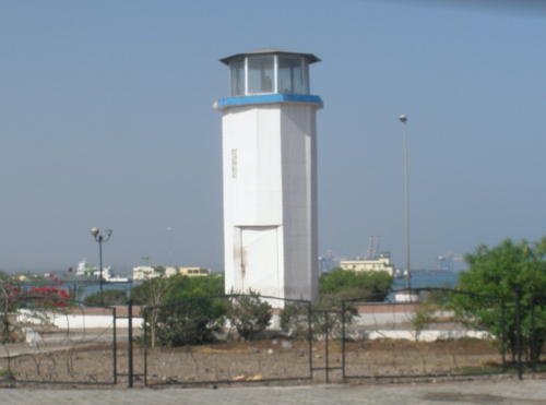
* Passe Ouest (Jetée du Gouvernement) (2)
Date unknown. Inactive. 10 m (33 ft) octagonal cylindrical concrete tower, painted white with blue trim. Nassir Moxa has a photo (also seen at right) and Google has a satellite view. The original lighthouse here was a skeletal tower carrying a leading light (white, red or green depending on direction, occulting twice every 6 s). The Admiralty announced the removal of this light in 2011. The present tower appears to carry a light, but not the leading light formerly listed. Located in a traffic roundabout in the Rue de Venice, on the Djibouti waterfront. Site open, tower closed. ex-Admiralty D7287; ex-NGA 31028.
[Port du Héron Range Rear]
Date unknown. Active; focal plane about 7 m (23 ft); quick-flashing red light. Approx. 7 m (23 ft) triangular skeletal mast standing on a square concrete base. Ibrahim Osman has a 2022 photo, Vincent Morgny has a photo showing both range lights, and Google has a satellite view. The Port du Héron (seen in the background of Morgny's photo) is a newer port southwest of the traditional Djibouti docks. Located on tidal flats south of the traditional harbor. Visible from the nearby street. Site status unknown. Admiralty D7286.1; NGA 31000.

Information available on lost lighthouses:

Notable faux lighthouses:


Passe Ouest Light, Djibouti, November 2011
Google Maps photo by Nassir Moxa

Adjoining pages: North: Eritrea | East: Somaliland

Return to the Lighthouse Directory index | Ratings key

Posted June 20, 2005. Checked and revised November 29, 2023. Lighthouses: 11. Site copyright 2023 Russ Rowlett and the University of North Carolina at Chapel Hill.