Lighthouses of Northwestern Estonia

The Republic of Estonia (Eesti in Estonian) is a small country with a surprisingly long coastline. Surrounded on 2-1/2 sides by water, it faces the Gulf of Riga (Liivi Laht) on the southwest, the Baltic Sea (Läänemere) on the west, and the Gulf of Finland (Soome Lahe) on the north. The country includes two large islands in the Baltic, Saaremaa and Hiiumaa, and countless small islands. To guard these coasts, Estonia has more than 100 lighthouses and a well-developed lighthouse administration.

Estonia's independence is recent. The country was part of the Swedish Empire from 1625 to 1710 and then part of the Russian Empire from 1710 until the end of World War I in 1918. After two decades of independence it was incorporated into the Soviet Union from 1940 to 1990. Thus the older lighthouses are from the Russian Imperial period and some of the newer ones are of Soviet construction.

This page includes lighthouses of the northwest coast, including the counties of Läänemaa and Hiiumaa. Lighthouses of the Gulf of Finland coast are on the Northern Estonia and Eastern Estonia pages, and lighthouses of the Gulf of Riga are on the Southwestern Estonia page.

Names in curly brackets {} are non-Estonian former names (Swedish or German).

In Estonian a lighthouse is a tuletorn (fire tower), a tulepaak (fire beacon), or a majakas (borrowed from the Finnish word majaka for a lighthouse). A daybeacon is called a päevamärk, saar is an island, poolsaar is a peninsula, parv is shoal, kari is a reef, neem is a cape or headland, väin is a strait, jõgi is a river, and sadam is a port or harbor.

Lighthouses in Estonia were operated previously by the Estonian Maritime Administration (Veeteede Amet, or VTA). In 2021 the functions of VTA were folded into the Estonian Transport Administration (Transpordiamet).

ARLHS numbers are from the ARLHS World List of Lights. VTA numbers are from the web site of the Estonian Maritime Administration. Admiralty numbers are from volume C of the Admiralty List of Lights & Fog Signals. U.S. NGA List numbers are from Publication 116.

General Sources
Navigatsioonimärkide andmekogu (Database of navigation signs)
Copied from the former VTA web site, photos and data for all the VTA beacons.
Eesti Tuletorni Selts
Web site of the Estonian Lighthouse Society (in Estonian).
Online List of Lights - Estonia
Photos by various photographers posted by Alexander Trabas.
Leuchttürme in Estland
Photos by Andreas Köhler taken in the summer of 2016.
Lighthouses in Estonia
Photos by various photographers available from Wikimedia.
World of Lighthouses - Estonia
Photos by various photographers available from Lightphotos.net.
Leuchttürme an der estländischen Ostseeküste
Photos of Estonian lighthouses posted by Bernd Claußen.
Lighthouses Estonia
Flickr.com album of photos by Joke Reijnen.
Six Remarkable Estonian Lighthouses
Information posted by Cybernetica AS, an Estonian manufacturer of aids to navigation.
Estonian Lighthouse Postcards
Historic postcard images posted by Michel Forand.
Leuchttürme...auf historischen Postkarten
Historic postcard views of Baltic state lighthouses from the collection of Klaus Huelse; the Estonian lights are near the bottom of the page.
List of Lights - Estonia
The official light list for Estonia, with text in both Estonian and English, can be downloaded as a pdf document.
GPSNauticalCharts
Navigational chart information for Estonia.
Navionics Charts
Navigational chart for Estonia.

Tahkuna Light
Tahkuna Light, Hiiumaa, September 2009
Wikimedia public domain photo by Kalervo Kinnunen

Hiiessaare Range Front Light, Hiiumaa, August 2006
Google Maps photo by Sven Vaarandi
Lighthouses of Hiiu County (Hiiumaa Parish)

The large island of Hiiumaa lies north of Saaremaa and off the northwestern coast of the mainland. The island is accessible by ferry from Rohuküla on the mainland to Heltermaa on Hiiumaa. Historically Hiiumaa was known as Dagö in both German and Swedish. In 2017 the four former parishes of Hiiu County were merged to form a single Hiiumaa Parish.

South Coast Lighthouses
*
Orjaku Range Front (2)
1962 (station established 1951). Active; focal plane 13 m (43 ft); continuous red light. 10 m (33 ft) round cylindrical concrete tower with gallery but no lantern, painted white with a black vertical stripe on the range line. Claußen has a photo, Trabas has VTA's photo, Toomas Joamets has a photo, and Google has a closeup street view and a satellite view. Orjaku is a ferry terminal and yacht harbor on the island of Kassari, just off the southeast coast of Hiiumaa. Located just north of the ferry terminal. Site open, tower closed. ARLHS EST-040; VTA 711; Admiralty C3644; NGA 12732.
* Orjaku Range Rear (2)
1962 (station established 1951). Active; focal plane 23 m (75 ft); continuous red light. 16 m (52 ft) round cylindrical concrete tower with gallery but no lantern, painted white with a black vertical stripe on the range line. Claußen has a photo, Trabas has VTA's photo, Oliver Sepp has a 2021 photo, and Google has a closeup street view and an indistinct satellite view. Located north of the ferry terminal, 800 m (1/2 mi) north of the front light (NGA's statement that the lights are 80 m apart is a typo). Site open, tower closed. ARLHS EST-041; VTA 712; Admiralty C3644.1; NGA 12736.
* Emmaste Range Front
1935. Active; focal plane 11 m (36 ft); quick-flashing white light. 11 m (36 ft) round cylindrical concrete tower with lantern and gallery, painted white. Claußen has photos, Trabas has VTA's photo, Toomas Joamets has a closeup photo, and Google has a satellite view. This is the entrance (eastbound) range for the Soela Strait, the narrow passage between Hiiumaa and Saaremaa. Emmaste is a village at the southernmost tip of Hiiumaa. Located just behind the Emmaste waterfront. Site open, tower closed. ARLHS EST-021; VTA 691; Admiralty C3720; NGA 12700.
Emmaste Range Rear (3)
2016 (station established 1935). Active; focal plane 19 m (62 ft); white light, 2 s on, 2 s off. 19 m (62 ft) round cylindrical tower painted white. The tower carries a rectangular colored red with a white vertical stripe. Trabas has VTA's photo, Juri Raudsepp has a winter 2023 photo, and Google has a satellite view. This lighthouse replaced a square skeletal tower built in 1947; the older tower appears in Claußen's 2003 photo and in Google's 2011 street view. Located about 1 km (0.6 mi) east of the front light (previous entry). Site status unknown. VTA 692; Admiralty C3720.1; NGA 12704.
* Sõru (Tohvri) Range Front
1934. Active; focal plane 13 m (43 ft); quick-flashing white light. 11 m (36 ft) round cylindrical concrete tower with lantern and gallery. Tower painted white, lantern and gallery red. Trabas has VTA's closeup, Claußen has photos showing both range lighthouses, the tower is freshly repainted in Triin Mõisaäär's 2019 photo, and Google has a street view and a satellite view. This range guides westbound vessels in the Soela Strait. Sõru is a ferry port near the tip of Hiiumaa's southern peninsula; the range lights guide ferries arriving from Triigi, Saaremaa, across the Soela Väin (strait) separating the two islands. Located just of the beach at Sõru about 12 km (7.5 mi) west of Emmaste. Site open, tower closed. ARLHS EST-052; VTA 701; Admiralty C3721; NGA 12707.
* Sõru (Tohvri) Range Rear
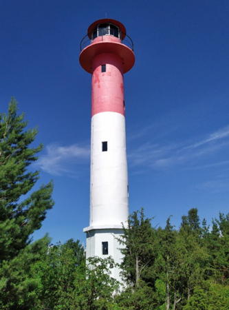
1934. Active; focal plane 18 m (59 ft); quick-flashing white light. 16 m (52 ft) round cylindrical concrete tower with lantern and gallery. Lower half of tower painted white; upper half, lantern and gallery painted red. Rene Hüvonen's 2021 photo is at right, Trabas has VTA's closeup, Claußen has photos of both range lighthouses, Forand has a historic postcard view, and Google has a street view and a satellite view. Located 490 m (0.3 mi) northwest of the front light. Site open, tower closed. . ARLHS EST-053; VTA 702; Admiralty C3721.1; NGA 12708.

Sõru Range Rear Light, Hiiumaa, June 2021
Google Maps photo by Rene Hüvonen
 
* [Haldreka]
1956. Inactive but maintained as a daybeacon. 28 m (92 ft) square cylindrical skeletal tower painted red. Most of the tower is covered by a slatted daymark; the upper half of the daymark is painted black and the lower half white. Kristjan Nebokat has a 2023 photo and Google has a satellite view. This beacon marks a shoal on the southwest coast of Hiiumaa. Located on a spit at Haldi, about 2 km (1.25 mi) northwest of Haldreka. Site open, tower closed. VTA 690.

Kõpu Peninsula Lighthouses
The narrow Kõpu Peninsula, also known by its German name Dagerort, projects about 25 km (15 mi) into the Baltic Sea from the west end of Hiiumaa.

****
Kõpu {Dagö, Dager Ort, Dagerort}
1531. Active; focal plane 102 m (335 ft); two white flashes every 10 s. 36 m (118 ft) massive square stone tower with four gigantic triangular buttresses, topped by a square brick extension, lantern, and gallery. Lighthouse painted white, lantern red. A photo by Ulla Kadakas is at right, Otto de Voogd has closeup photos, another good closeup is available, Trabas has the photo from VTA's page, Wikimedia has many photos, Huelse has a historic postcard view, Forand has an older postcard view, and Google has a street view and a satellite view. Certainly one of the world's most imposing lighthouses and one of the oldest continuously operated light stations in the world. Construction began in 1507. Originally an open fire was kept atop the tower, which at first was only as tall as the top of the buttresses. The brick top section of the tower was built in 1659. The Russian government took over operation of the tower from local authorities in 1805 and added a lantern in 1845. The Sautter, Marlé & Co. Fresnel lens was purchased at the Paris Worlds Fair in 1900 and installed in 1901. The Soviet government repaired and restored the aging tower several times, and the upper section of the tower was restored in 2001. Today the old lighthouse is Hiiumaa's leading tourist attraction, featuring a spectacular view of the Baltic and the entrance to the Gulf of Finland. There is a visitor center with a café and parking is provided. Located on highway 139 atop Tornimägi ("Tower Mountain"), the highest hill of the Kõpu Peninsula, about 6 km (4 mi) east of the end of the peninsula at Ristna. Site open, tower open (for a small fee) daily May 1 through September 30. Site manager: Kõpu Tuletorn . ARLHS EST-006; VTA 668; Admiralty C3746; NGA 12720.

Kõpu Light, Körgessaare, April 2023
Wikimedia Creative Commons photo by Ulla Kadakas
* Ristna
1874. Active; focal plane 37 m (121 ft); white or red light, depending on direction, 3 s on, 12 s off; white light is shown to the west and red to the east. 30 m (98 ft) hexagonal tower, cast iron encased in concrete with six stout ribs, lantern, and gallery. Lighthouse painted bright red; lantern dome painted white. This lighthouse marks the westernmost point of Hiiumaa. Sven Vaarandi's photo is at right, Tero Koski also has a good photo, Wikimedia has photos, Trabas has the photo from VTA's page, Claußen's page has photos, Google has a street view, and Bing has a satellite view. The original lighthouse, prefabricated in France, was a hexagonal skeletal tower with central cylinder; Forand has a postcard view showing the original form of the tower. The lighthouse was encased in concrete in 1920 after being damaged during World War I. Located at the end of the Kõpu Peninsula near the village of Ristna. Site and tower closed but the lighthouse can be seen from nearby. . ARLHS EST-049; VTA 673; Admiralty C3744; NGA 12716.

North Coast Lighthouses
** Tahkuna {Tackerort}
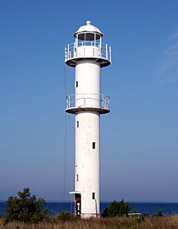
1875. Active; focal plane 43 m (141 ft); white light, 3 s on, 3 s off, 3 s on, 6 s off. 43 m (141 ft) round cast iron tower with lantern and gallery, painted white; lantern dome is red. Kalervo Kinnunen's photo is at the top of this page, a 2022 photo and a fine 2007 photo are available, Trabas has the photo from VTA's page, Claußen's page has photos, Huelse has a historic postcard view, Forand also has a historic photo, and Google has a street view and a satellite view. This lighthouse marks the northernmost point of Hiiumaa, overlooking the mouth of the Gulf of Finland. This lighthouse and the Ristna lighthouse were prefabricated in the same French factory in 1874. It is claimed locally that they were switched, with this taller tower intended originally for Ristna. There was heavy fighting here in 1941 when Russian forces made a last stand against invading German troops; fortunately the lighthouse survived. Located on Tahkuna Neem (Point) about 1.75 km (1.1 mi) northwest of the village of Tahkuna. Site open, tower open by arrangement with the caretaker. . ARLHS EST-014; VTA 645; Admiralty C3754; NGA 12728.
* Kärdla Range Rear
Date unknown. Active; focal plane 21 m (69 ft); white flash every 2 s visible only along the range line. 17 m (56 ft) square cylindrical skeletal tower, painted black, carrying a slatted daymark painted white with a green vertical stripe. Trabas has VTA's photo and Google has a satellite view. This is the approach range for Kärdla, a small port about 15 km (9 mi) southeast of Tahkuna. The front light is on a short post. Located a short distance southeast of the town. Accessible by road. VTA 643.2; Admiralty C3755.51; NGA 12729.1.
 
Ristna Light
Ristna Light, Ristna, July 2011
Wikimedia Creative Commons photo by Sven Vaarandi
* Hiiessaare (Hiiesaare)
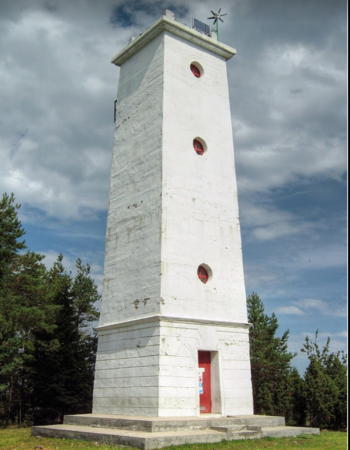
1876. Active; focal plane 19 m (62 ft); white light, 2 s on, 4 s off. 17 m (56 ft) square concrete tower with gallery but no lantern, mounted on a 1-story square stone base. Entire lighthouse painted white. Sven Vaarandi's photo is at the top of this page, Trabas has the photo from VTA's page, Daniel Tuulik has a 2018 photo, and Google has a satellite view. Hiiessaare is a small village on the northeastern coast of Hiiumaa. This was formerly the front light of a range, but the rear light (next entry) has been discontinued. Located near the waterfront. Site open, tower closed. ARLHS EST-076; VTA 625; Admiralty C3756; NGA 12730.
* Paluküla (Hiiessaare Range Rear)
Date unknown. Inactive since about 2001. Square cylindrical church steeple with a tall square pyramidal spire. Church painted white. The rear light of the Hiiesaare Range was formerly displayed from this steeple. The steeple is still listed as a daybeacon. Estonian Wikipedia has an article with photos, Google has a street view, and Bing has a satellite view. Located in Paluküla, about 3.5 km (2 mi) east of Kärdla and 2.8 km (1.75 mi) southwest of the front light. Site open, tower closed. ARLHS EST-082; VTA 626; ex-Admiralty C3756.1.

Lighthouses of Lääne County

Lääne ("Western") County occupies the northwestern corner of mainland Estonia opposite Hiiumaa. It also includes Vormsi and other islands between Hiiumaa and the mainland.

Haapsalu Parish Lighthouses
Rohuküla Range Rear (4?)
2016 (station established 1916). Active; focal plane 24 m (79 ft); white light, 1.5 s on, 1.5 s off. 19 m (62 ft) round metal tower, painted black. The tower carries a large slatted daymark, painted white with a black vertical stripe. Trabas has VTA's photo and Bing has a satellite view. Google's distant 2012 street view shows the top of the 1953 tower, a square pyramidal skeletal tower painted red. The front light is on a shorter skeletal tower. Located in a field on the east side of Rohuküla. Site status unknown. VTA 532; Admiralty C3653.1; NGA 12572.
* Paralepa Range Front (2)
1934 (station established 1916). Active; focal plane 15 m (49 ft); quick-flashing white light visible only on the range line. 15 m (49 ft) round cylindrical concrete tower with lantern and gallery, painted white. Trabas has the photo from VTA's page, Claußen's page has photos of both range lights, Aimar Peepson has a 2018 photo, Juri Morjakov has a 2021 photo, and Google has a satellite view. This range guides ships southbound through the Voosi Strait between Hiiumaa and the mainland. Located on the south side of Haapsaul Bay a short distance west of Haapsalu. Site open, tower closed. . ARLHS EST-043; VTA 471; Admiralty C3651; NGA 12592.
* Paralepa Range Rear (2)
1934 (station established 1916). Active; focal plane 37 m (121 ft); white light visible only on the range line, 2 s on, 2 s off. 31 m (102 ft) slender round cylindrical concrete tower with lantern and gallery. Tower painted mostly white, with the top 1/4 black and a single black band in the white section. Trabas has the photo from VTA's page, Claußen's page has photos of both range lights, Jaan Rebane has a photo, Joonatan Aruväli has a 2017 photo, Sergei Sergeevich has a 2021 drone view, and Google has a satellite view. Located about 800 m (1/2 mi) south southeast of the front light. Site open, tower closed. ARLHS EST-042; VTA 472; Admiralty C3651.1; NGA 12596.

Hobulaid Lighthouses

Hobulaid (called Hästholm in Swedish) is a small, uninhabited island located midway between the mainland of Ridala Parish and the southeastern tip of Vormsi. The narrow island is about 2.5 km (1.5 mi) long, extending north and south. For reasons unknown to us Hobulaid is not part of Lääne County; it is administered by the parish of Märjamaa in Rapla County in central Estonia.

Rukkirahu (Range Rear) (3)
1940 (station established 1860). Active; focal plane 18 m (59 ft); two flashes every 6 s, white or red depending on direction. 16 m (52 ft) round cylindrical concrete tower with lantern and gallery, painted white. Trabas has the photo (also seen at right) from VTA's page, Claußen has a photo, a 2021 photo is available, and Google has a satellite view. Sibling of the Pöörilaid lighthouse. This light marks a "crossroads" off Rohuküla; shipping between Ruhuküla and the islands of Hiiumaa and Vurmsi passes east and west while coastwise traffic passes north and south. The light also functions with the Hobulaid South light as the rear light of a southbound range guiding vessels as they leave the Voosi Strait. Located on Rukkirahu, a small island about 5 km (3 mi) west of Rohuküla. Accessible only by boat. Site and tower closed, but there is a view of the lighthouse from the Rohuküla to Hiiumaa ferry. . ARLHS EST-073; VTA 482; Admiralty C3652.1; NGA 12588.1.
Hobulaid {Hästholm} South (Range Front) (3)
2012 (station established 1908). Active; focal plane 5 m (17 ft); flash every 2.5 s, white or red depending on direction. 5 m (17 ft) round cylindrical metal tower with lantern mounted on a concrete base. Tower painted red, concrete base white. Wikimedia has Ivar Leidus's 2013 photo, Trabas has the VTA closeup, and Google has a distant satellite view. Claußen has a photo of the second (1934) light. Located at the southern tip of the small island of Hobulaid, about 3.7 km (2.3 mi) north of the Rokkirahu lighthouse. Accessible only by boat. Site and tower closed. ARLHS EST-066; VTA 481; Admiralty C3652; NGA 12588.
Rukkirahu Light
Rukkirahu Light
Estonian Maritime Administration photo
Hobulaid {Hästholm} North (Voosi Kurk Range Rear)
Date unknown (station established 1916). Active; focal plane 24 m (79 ft); white light, 1.5 s on, 1.5 s off. 19 m (62 ft) square cylindrical skeletal tower, painted green. The tower also carries a slatted daymark painted white with a black vertical stripe. Trabas has a VTA photo, a 2019 photo is available, and Google has a satellite view. The range guides vessels southbound as they enter the north end of the Voosi Strait (kurk is Estonian for "throat") between Vormsi and the mainland. Located near the northern end of the island of Hobulaid, 2.5 km (1.5 mi) south of the front light. Accessible only by boat. VTA 466; Admiralty C3650.1; NGA 12612.
Uppholmi (Voosi Kurk Range Front)
Date unknown (station established 1923). Active; focal plane 9.5 m (31 ft); quick-flashing white light. 12 m (39 ft) square cylindrical skeletal tower, painted red and mounted on a round concrete pier. The tower also carries a slatted daymark painted white with a black vertical stripe. Trabas has a VTA photo, Claußen has a distant view, and Google has a satellite view. Located about 1.2 km (3/4 mi) east of Cape Uppholm, the southeastern tip of Vormsi. Accessible only by boat. VTA 465; Admiralty C3650; NGA 12608.

Vormsi Parish Lighthouses
Vormsi is an island northeast of Hiiumaa, separated from the mainland by the Voosi strait. The island is accessible by ferry from Rohuküla on the mainland. The island was formerly called Wormsö in German and Ormsö in Swedish.

*
Sviby Range Rear
1949. Active; focal plane 11 m (36 ft); white light occulting once every 6 s. 10 m (33 ft) round cylindrical tower with gallery and a boxlike lantern. Lighthouse painted red. The tower also carries a large slatted daymark painted white with a black vertical stripe. Claußen has a page for the range lights, Trabas has Klaus Kern's photo, a 2022 closeup is available, Google has a distant street view, and Bing has a satellite view. This range guides vessels into the harbor of Sviby on the southeastern coast of Vormsi. The front light is on a mast. Located on the waterfront, west of the ferry terminal in Sviby. Site open, tower closed. VTA 562; Admiralty C3655.1.
Harilaid (Harilaiu) Range Rear (3)
1940 (station established 1845). Active; focal plane 12 m (39 ft); white, red, or green light, depending on direction, 2 s on, 2 s off. 12 m (39 ft) round cylindrical concrete tower with lantern and gallery, painted white. Trabas has the photo from VTA's page (also seen at right), Martin Villig has a 2021 closeup, and Google has a distant satellite view. Huelse has a historic postcard view of a former lighthouse on this island. This is the rear light of a range leading north northwest through the Hari Strait between Hiiumaa and the smaller island of Vormsi. The front light is on a tall post. Located on the small island of Harilaid, off the west coast of Vormsi. Accessible only by boat. Site and tower closed. ARLHS EST-002; VTA 587; Admiralty C3758.51; NGA 12564.
 

Harilaid Range Rear Light, Vormsi
Estonian Maritime Administration photo
 
* Vormsi (Saxby) {Wormsö, Ormsö} (2)
1871 (station established 1864). Active; focal plane 27 m (89 ft), white, red, or green light, depending on direction, 3 s on, 3 s off. 24 m (79 ft) round cast iron tower with lantern and gallery, painted white; lantern painted red. A 2012 photo is at right, Trabas has a VTA photo, VTA has a different photo on its page, Ellen Kink has a 2017 photo, Claußen has a page with good photos, Otto de Voogd has photos taken in the winter of 2006, Huelse has a historic postcard photo, and Bing has a satellite view. This lighthouse was prefabricated at Liepaja (then Libau) in Lithuania. It replaced an 1864 cast iron tower of English manufacture, which was relocated to Vaindloo in the Gulf of Finland after it was found to be too short to work effectively at this location. The lighthouse is both the rear light for Vormsi North Range and the front light for the Vormsi Southeast Range. Located on Saxby Neem, the northwest point of Vormsi, about 2 km (1.2 mi) west of the town of Saxby. Site open, tower closed. . ARLHS EST-064; VTA 595; Admiralty C3758; NGA 12631.
Vormsi North Range Front
Date unknown. Active; focal plane 16 m (52 ft); quick-flashing white light. 16 m (52 ft) square skeletal tower, lower third pyramidal and upper 2/3 cylindrical. The tower is painted black and carries a large slatted daymark painted white with a black vertical stripe. Trabas has the photo from VTA's page, Aleksei Belkin has a photo, a 2017 photo is available, Hillar Valgma has a 2021 street view, and Bing has a fuzzy satellite view. Located on the beach about 250 m (820 ft) south of the Vormsi lighthouse. Site open, tower closed. VTA 596; Admiralty C3758.1; NGA 12632.
Vormsi Southeast Range Rear (2)
1957. Active; focal plane 41 m (135 ft); white light, 3 s on, 3 s off. 35 m (115 ft) square cylindrical skeletal tower. On the side facing the range the upper half of the tower has a slatted daymark painted white with a black horizontal band at the top. Trabas has a VTA photo and Google has a street view and a satellite view. Located 1 km (0.6 mi) south southeast of the Vormsi lighthouse (previous entry). Site status unknown. VTA 594; Admiralty C3757.9; NGA 12630.
* Norrby Range Front (2)
1935 (station established 1916). Active; focal plane 22 m (72 ft); white light occulting once every 2 s, visible only on or close to the range line. 22 m (72 ft) round cylindrical concrete tower with lantern and gallery, painted white. Claußen has a page with good photos, Trabas has the photo from VTA's page, a 2007 photo and a 2022 closeup are available, and the lighthouse is barely visible in the forest in Google's satellite view. This is the approach range for the narrow Voosi Väin (strait) east of Vormsi. Located on the northeast coast of Vormsi near Norrby. Site open, tower closed. ARLHS EST-038; VTA 447; Admiralty C3759; NGA 12614.

Vormsi Light, Saxby, August 2012
Wikimedia Creative Commons photo by Juks
* Norrby Range Rear (2)
1935 (station established 1916). Active; focal plane 35 m (115 ft); white light occulting once every 2 s, visible only on or close to the range line. 32 m (105 ft) round cylindrical concrete tower with lantern and gallery, mounted on a 2-story octagonal base. Lantern and upper third of tower painted red, lower 2/3 of tower painted white. Trabas has a the photo from VTA's page, Claußen has a page with good photos, and Google has a satellite view. Located on the northeast coast of Vormsi near Norrby, 950 m (0.6 mi) south southwest of the front light. Site open, tower closed. ARLHS EST-039; VTA 448; Admiralty C3759.1; NGA 12614.1.

Lääne-Nigula Parish Lighthouses
* Paslepa {Ramsholm} Range Front (2)
1935 (station established 1916). Active; focal plane 10 m (33 ft); quick-flashing red light visible only on or close to the range line. 10 m (32 ft) round cylindrical concrete tower with lantern and gallery, painted white. Trabas has the photo from VTA's page, Vaarandi has a photo, and Google has a satellite view. This range guides vessels entering Paslepa Bay. Located on the coast near the southern coast of Paslepa Bay. Site open, tower closed. ARLHS EST-044; VTA 441; Admiralty C3759.5; NGA 12616.
* Paslepa {Ramsholm} Range Rear (2)
1935 (station established 1916). Active; focal plane 15 m (49 ft); red light occulting every 2 s, visible only on or close to the range line. 14 m (46 ft) round cylindrical concrete tower with lantern and gallery, painted white. Trabas has the photo from VTA's page and Google has a street view and a satellite view.Located on the coast near the northwestern tip of the Paslepa peninsula, 500 m (0.3 mi) southwest of the front light. Site open, tower closed. ARLHS EST-045; VTA 442; Admiralty C3759.51; NGA 12620.
* [Talisna {Telise} Dayrange Rear]
Date unknown. Daybeacon, unofficial and never lit as far as we know. Approx. 10 m (33 ft) round conical rubblestone tower. Sven Vaarandi has a photo, another photo is available, and Google has an indistinct satellite view of the location. There is also a similar but much shorter front tower. Located on the coast near Kudani. Site open, tower closed.
[Riguldi]
1996. Inactive but listed as a daybeacon. 29 m (95 ft) square skeletal tower. All sides of the upper half of the tower are covered by a slatted daymark; depending on which side either the upper or lower half of the daymark is painted black and the rest white. Lightphotos.net has Sven Vaarandi's photo but trees hide the shadow of the tower in Google's satellite view. Located near the village of Riguldi on Estonia's northwest coast. Site status unknown. VTA 435.
* Põõsaspea (2)
Around 2018 (station established 1923). Active; focal plane 17 m (56 ft); white flash every 3 s. 16 m (52 ft) round tower, the upper half surrounded by a square slatted daymark. The upper half of the daymark is painted red and the lower half and the tower are painted white. Trabas has the photo from VTA's page and Google has an indistinct satellite view. This light replaced a square cylindrical skeletal tower with gallery. Alland Parman has a 2016 photo of the earlier light and Google has a 2011 street view. Located on a sandy point at the extreme northwestern tip of the Estonian mainland. Site open, tower closed. VTA 420; Admiralty C3764; NGA 12752.
Osmussaar {Odensholm, Odinsholm} (5)
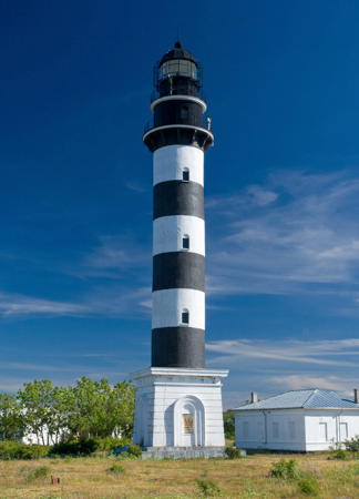
1954 (station established 1766). Active; focal plane 39 m (128 ft); two white flashes every 18 s. 35 m (115 ft) round cylindrical concrete tower with lantern and double gallery, mounted on a 1-story square cement block base. Tower painted with black and white horizontal bands; lantern, gallery and watch room painted black; base painted white. 1-story keeper's house and other buildings. Sven Vaarandi's photo is at right, Trabas has the photo from VTA's page, Sergey Melkonov has a 2007 photo, Wikimedia has numerous photos, Markko Toppi has a closeup photo, and Google has a satellite view. Osmussaar is a small island 7.5 km (4.7 mi) off the northwestern tip of the Estonian mainland in the mouth of the Gulf of Finland; the lighthouse here plays a critical role in guiding ships into the Gulf from the Baltic Sea. Until 1940 the island had a small Swedish-speaking population who called the island Odensholm. In 1941 this was the last place in Estonia to surrender to the Germans; the 1850 stone lighthouse (the third on the island) was destroyed in the fighting. Huelse has a historic postcard view of the old lighthouse. A temporary wooden tower (1946) was replaced by the present lighthouse. Today the island is uninhabited, although it is visited fairly regularly by ecotours from Haapsalu; it is set aside as a nature reserve. Located at the northwestern tip of the island. Site open, tower closed. . ARLHS EST-009; VTA 425; Admiralty C3760; NGA 12748.

Osmussaar Light, Osmussaar, June 2008
Wikimedia Creative Commons photo by Sven Vaarandi

Information available on lost lighthouses:

Notable faux lighthouses:

Adjoining pages: East: Northern Estonia | South: Southwestern Estonia

Return to the Lighthouse Directory index | Ratings key

Posted May 1, 2005. Checked and revised July 2, 2023. Lighthouses: 31. Site copyright 2023 Russ Rowlett and the University of North Carolina at Chapel Hill.