Lighthouses of Finland: North Ostrobothnia

The Republic of Finland (Suomi in Finnish) is a country of northern Europe with coastlines facing south on the Gulf of Finland (Suomenlahti) and west on the Gulf of Bothnia (Pohjanlahti), both arms of the Baltic Sea. Finland also administers the Åland Islands (Ahvenanmaa), an archipelago at the junction of the two gulfs. After centuries of rule by Sweden, Finland was conquered by Russia in 1809 and became an autonomous grand duchy within the Russian Empire. The country declared its independence from Russia at the start of the Russian Revolution in 1917. It lost some of its eastern territory to Russia as a result of World War II but has retained its independence.

Finland is divided into nineteen regions (maakunta) and the regions are divided into municipalities. This page includes the lighthouses of the North Ostrobothnia Region (called Pohjois-Pohjanmaa in Finnish and Norra Österbotten in Swedish). This region faces the northern end of the Gulf of Bothnia, locally called the Bothnian Bay (Perämeri in Finnish, Bottenviken in Swedish). It is shallow, with numerous shoals and islands, creating a need for many navigational aids.

The Finnish word for a lighthouse is majakka (plural majakat). Saari is an island, luoto is an islet or skerry, niemi is a cape or headland, niemimaa is a peninsula, lahti is a bay, salmi is a strait, joki is a river, and satama is a port or harbor. Swedish is a second official language in Finland, and some of the lighthouses are commonly known by their Swedish names.

Special thanks to Teemu Vehkaoja for photos and information on lighthouses of this area.

Lighthouses in Finland are maintained by the Waterways Section of the Finnish Transport Agency (Liikennevirasto).

ARLHS numbers are from the ARLHS World List of Lights. SU numbers are from the official Finnish light list. Admiralty numbers are from volume C of the Admiralty List of Lights & Fog Signals. U.S. NGA List numbers are from Publication 116.

General Sources
Online List of Lights - Finland
Photos by various photographers posted by Alexander Trabas.
Finskt fyrväsende
Photos and information posted by the Swedish Lighthouse Society.
Galleria Majakat
Photos posted by Kimmo Koivunen.
World of Lighthouses - Finland
Photos by various photographers available from Lightphotos.net.
Lighthouses in Finland
Photos by various photographers available from Wikimedia.
Lighthouses in Finland
Aerial photos posted by Marinas.com.
Weitere Europäische Leuchttürme auf historischen Postkarten
Historic postcard images posted by Klaus Huelse.
List of Lights
The Finnish light list is available for download.
Finnish Lighthouse Society
The national lighthouse preservation association.
GPSNavigationCharts
Navigation chart information for western Finland.
Navionics Charts
Navigational chart for western Finland.
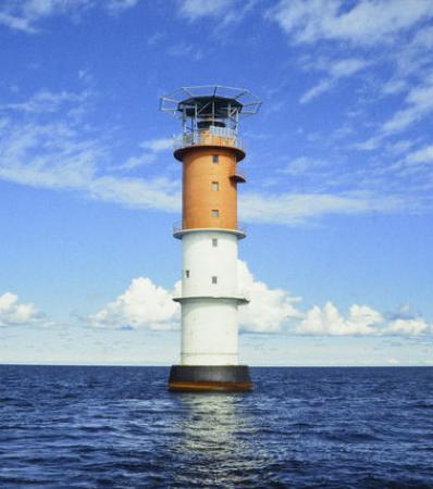

Nahkiainen Light, Raahe, 1999
Wikimedia Creative Commons photo by Finnish Heritage Agency
Kalajoki Lighthouses
Lepänen Range Rear
Date unknown. Active; focal plane 26 m (78 ft); white light, 2 s on, 4 s off. 25 m (82 ft) triangular cylindrical skeletal tower carrying a large rectangular daymark colored red with a yellow vertical stripe. Trabas has a photo and Bing has an indistinct satellite view. This is an approach range for Kalajoki, a town of about 12,500 residents. Located on a small island east of the larger island of Lepänen. Accessible only by boat. Site status unknown. SU-9191; Admiralty C4192.51; NGA 18343.1.
** Ulkokalla
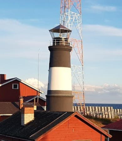
1872 (Axel Hampus Dahlström). Active; focal plane 17 m (56 ft); three white flashes every 20 s. 12 m (39 ft) round masonry tower with lantern and gallery, mounted on a round cylindrical base. Lighthouse painted black with one white horizontal band. A large wood keeper's house is now open for overnight accommodations. Jarmo Pirttijärvi has a closeup photo and a view of the station (a portion is seen at right), Raija Isomäki has a 2022 photo of the station and a closeup of the tower, the Swedish Lighthouse Society has a page for the lighthouse, and Google has a distant satellite view. The original keepers houses burned in 1944; the present building was constructed in 1958. Located on a small island about 20 km (13 mi) west of Kalajoki. Boat transportation is available from Kalajoki during the summer. Site open; light station and tower open to paying guests. . ARLHS FIN-069; SU-9190; Admiralty C4192; NGA 18392.

Raahe Lighthouses
Raahe is an industrial town and seaport having a population of about 25,000.

Nahkiainen
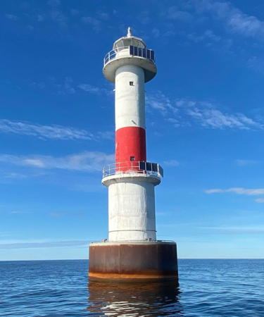
1956 (lightship station established 1892). Active; focal plane 28 m (92 ft); four white flashes every 20 s. 24 m (79 ft) round cylindrical concrete tower, incorporating keeper's quarters, with lantern, two galleries, and a helipad on top of the lantern. Upper half of the lighthouse painted red, lower half white. A photo is at the top of this page, the Swedish Lighthouse Society has a page for the lighthouse, and Bing has a satellite view. Located on a shoal about 16 km (10 mi) north of Kalajoki and 25 km (15 mi) west of Raahe. Accessible only by boat. Site open, tower closed. ARLHS FIN-032; SU-9030; Admiralty C4188; NGA 18400.

Ulkokalla Light, Kalajoki, August 2017
Google Maps photo by Jarmo Pirttijärvi
Raahe
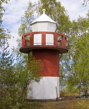
1965. Active; focal plane 22 m (72 ft); two yellow flashes every 10 s. 19 m (62 ft) round cylindrical 2-stage concrete tower with lantern and two galleries, mounted on a round concrete pier. Lighthouse painted white with one red horizontal band. Pirjo Jortama's 2022 photo is at right, another photo is available, Wikimedia has a 1999 photo, the Swedish Lighthouse Society has a page for the lighthouse, sea kayakers have several 2015 photos, and Bing has a satellite view. This lighthouse shares its design with the three Oulu lighthouses (see below). FMA restored the lighthouse in 2009. Located on a shoal about 12 km (7.5 mi) west of Raahe. Accessible only by boat. Site open, tower closed. . ARLHS FIN-045; SU-9031; Admiralty C4183; NGA 18404.
Elko Range Rear
Date unknown. Active; focal plane 25 m (82 ft); white light, 2 s on, 2 s off. Approx. 22 m (72 ft) square cylindrical skeletal tower carrying a large rectangular daymark colored red with a yellow vertical stripe. Trabas has a photo and the Bing has a satellite view. The front light is on a small concrete tower. Located on an island off the waterfront of the Elko industrial harbor on the south side of Raahe. Accessible only by boat. Site status unknown. SU-9032; Admiralty C4184.1; NGA 18424.
[Iso-Kraaseli]
1852. Daybeacon. 18 m (59 ft) octagonal pyramidal wood tower; the upper half is enclosed and painted white. Kaisa Kinnunen-Luovi has a closeup photo, Finnish Wikipedia has a page with a distant view of the beacon, and Bing has a satellite view. The Raahe pilot station is adjacent to this beacon; both buildings have been maintained by the city of Raahe since 1983. Located near the north end of Iso-Kraaseli, an island about 4 km (2.5 mi) west of the Raahe waterfront. Site open, tower closed. .
* Raahen Kirkko (Raahe Church)
1932. Inactive since about 1960. The light was mounted on the steeple of the historic Raahe Church. Wikimedia has a photo and Google has a street view and a satellite view. Located in downtown Raahe. Site open, tower closed. ex-Admiralty C4174.
[Tasku]
1853. Daybeacon. 19 m (62 ft) square wooden tower, the lower half cylindrical and the upper half pyramidal. Tower painted a light brown. Vesa Hyytiäinen has a closeup photo, Riikka Sippala has a photo, and Google has a satellite view. One of several historic daybeacons in service in northern Finland. Located on the small island of Tasku, about 5 km (3 mi) northwest of Raahe. Accessible only by boat. Site open, tower closed. .
Karjula
Date unknown. Active; focal plane 12 m (39 ft); four white flashes every 20 s. 12 m (39 ft) round tower painted white with a red horizontal band, No photo available but Bing has a satellite view. This beacon marks a sharp turn in the deepwater channel of the Bothnian Bay. Located about 16 km (10 mi) west northwest of Raahe. Accessible only by boat. Site open, tower closed. SU-62870; Admiralty C4180; NGA 18442.

Raahe Light, Raahe, August 2022
Instagram photo by Pirjo Jortama

Siikajoki Lighthouse
* Tauvo
1978. Active; focal plane 34 m (112 ft); white light, 2 s on, 4 s off. 30 m (98 ft) square pyramidal steel skeletal tower with gallery. The tower also carries a solid rectangular daymark, painted black. Wikimedia has a closeup photo by Teemu Vehkaoja, who also has a portfolio of photos taken in 2010. Trabas has a closeup photo and Google has a satellite view. Located on a low cape about 12 km (7.5 mi) northeast of Raahe and a similar distance west of Siikajoki. Site open and it appears that the lighthouse should be accessible by a fairly short walk on the beach. Tower closed. . ARLHS FIN-067; SU-9027; Admiralty C4172; NGA 18444.

Hailuoto Lighthouses
Hailuoto is an island municipality in the Bothnian Bay off the city of Oulu. The island has a population of about 1000. It is accessible by ferry in the summer and by an official ice road in the winter.

#[Itänenä]
1935. Demolished in 2007. This daybeacon (it was never lighted) was a 30 m (98 ft) square steel skeletal tower carrying a large slatted daymark. The tower was demolished in 2007 because it posed a hazard to daredevil climbers. Located on the southeastern coast of Hailuoto. Site open.
** Marjaniemi
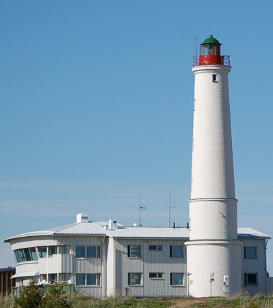
1872 (Axel Hampus Dahlström). Active; focal plane 20 m (98 ft); two white flashes every 20 s. 25 m (82 ft) round masonry tower with lantern and gallery, mounted on a round cylindrical base. Lighthouse painted white; lantern painted red with a green dome. The 2-story pilot station next to the lighthouse is now an inn, the Luotsihotelli, offering overnight accommodations. Trabas has Teemu Vehkaoja's photo (it also appears at right), the Swedish Lighthouse Association has a page for the lighthouse, Timo Suomela has a July 2007 closeup photo, Marinas.com has aerial photos, Huelse has a historic postcard view, Google has a street view, and Bing has a satellite view of the station. The lighthouse was preceded by a series of daybeacons starting at least by 1800. This handsome tower is one of the oldest, best known, and most accessible lighthouses of northern Finland. Located on a sharp point at the western tip of the island of Hailuoto, about 50 km (30 mi) west of Oulu. The island is accessible by auto ferry, and the lighthouse is at the end of highway 816, which crosses the island. Site open; guided tours of the lighthouse are available during the summer season. . ARLHS FIN-028; SU-9114; Admiralty C4142.1; NGA 18452.
Marjaniemi Light
Marjaniemi Light, Hailuoto, June 2007
Wikimedia Creative Commons photo by Teemu Vehkaoja
* [Keskiniemi (Karvo) (1)]
1858. Never lit as a lighthouse. 19 m (62 ft) square pyramidal wood tower rising from a square 1-story base. Tower painted white, roof black. Teemu Vehkaoja's photo is at right, he also has a portfolio of photos, and Bing has a satellite view. This historic tower has always been a daybeacon only, but there is a lightbeacon nearby (next entry). Located on a promontory on the northwestern coast of Hailuoto. Site open, tower closed. .
* Keskiniemi (Karvo) (Range Front)
1908 (daybeacon established 1858). Active; focal plane 9 m (29 ft); white flash every 6 s. 9 m (30 ft) square skeletal steel tower with white lantern and gallery, with an unused wooden gas-bottle storage shed at the foot of the tower. Trabas has a closeup photo by Teemu Vehkaoja and Bing has a satellite view. Located on a promontory on the northwestern coast of Hailuoto. The light is accessible by foot or car, located 6.3 km (3.9 miles) northeast of Marjaniemi Lighthouse. Site open, tower closed. ARLHS FIN-080; SU-8965; Admiralty C4147.05; NGA 18477.
Hyyppänmäki (Keskiniemi Range Rear) (3)
1987 (station established 1874 but not lighted until 1937). Inactive since about 1997; although the rear light has been discontinued the tower is maintained as a daybeacon. The tower also carries two radar antennas. Approx. 23 m (75 ft) triangular cylindrical skeletal tower with gallery. The tower carries a rectangular daymark colored red with a yellow vertical stripe. Wikimedia has a photo and Google has a satellite view and a street view through trees. There is a 1912 historic photo of the 1874 tower, then a daybeacon. It was replaced by a skeletal tower in 1958. Hyyppänmäki (Hyyppä Hill) is a sand ridge in the center of Hailuoto. Located 7 km (4 mi) southeast of the front light. Site open, tower closed. ex-Admiralty C4144.1.
Oulu 1
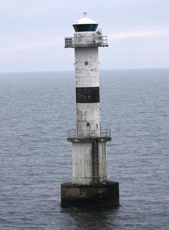
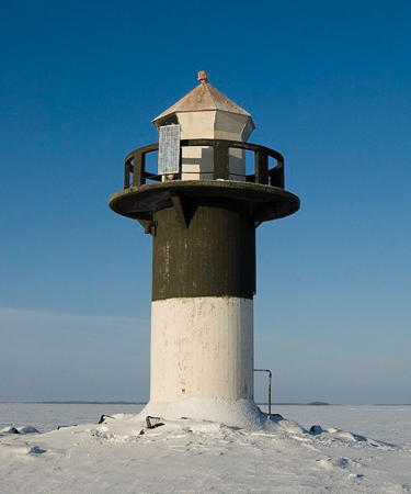
1965. Active; focal plane 22 m (72 ft); flash every 5 s, white, red or green depending on direction. 24 m (79 ft) round cylindrical 2-stage masonry tower with lantern and two galleries, mounted on a round concrete pier. Lighthouse painted black with one white horizontal band. Trabas has a photo by Capt. Theo Hinrichs and the Swedish Lighthouse Association has a page for the three Oulu lighthouses, but the lighthouse is not shown in Google's satellite view. This is the outermost of three identical lighthouses built to guide ships around the north side of Hailuoto island to the port of Oulu. Each of the lighthouses has directional lights that define the proper channel. Located about 8 km (5 mi) northwest of the Marjaniemi lighthouse. Accessible only by boat, but there is a distant view from Marjaniemi. Site open, tower closed. ARLHS FIN-037; SU-8969; Admiralty C4145; NGA 18472.
Keskiniemi Beacon
Keskiniemi Daybeacon, Hailuoto, June 2007
Wikimedia Creative Commons photo by Teemu Vehkaoja
Oulu 2
1965. Active; focal plane 22 m (72 ft); two flashes every 6 s, white, red or green depending on direction. 24 m (79 ft) round cylindrical 2-stage masonry tower with lantern and two galleries, mounted on a round concrete pier. Lighthouse painted white with one narrow black horizontal band. Trabas has a photo by Capt. Theo Hinrichs (also seen at right), Lightphotos.net has the same photo, the Swedish Lighthouse Association has a page for the three Oulu lighthouses, and Bing has a satellite view. This is the second of three identical lighthouses built to guide ships around the north side of Hailuoto island to the port of Oulu. Located about 6.5 km (4 mi) north of the Marjaniemi lighthouse. Accessible only by boat, but there is a distant view from Marjaniemi. Site open, tower closed. ARLHS FIN-038; SU-9141; Admiralty C4146; NGA 18476.
Oulu 3
1964. Active; focal plane 22 m (72 ft); three flashes every 10 s, white, red or green depending on direction. 24 m (79 ft) round cylindrical 2-stage masonry tower with lantern and two galleries, mounted on a round concrete pier. Lighthouse painted white with one red horizontal band. Trabas has a photo by Capt. Theo Hinrichs, Lightphotos.net has the same photo, the Swedish Lighthouse Association has a page for the three Oulu lighthouses, and Bing has a satellite view. This is the innermost of three identical lighthouses built to guide ships around the north side of Hailuoto island to the port of Oulu. Located about 3 km (2 mi) off the north coast of Hailuoto. Accessible only by boat, but there is distant views from the shore of Hailuoto. Site open, tower closed. ARLHS FIN-039; SU-8972; Admiralty C4147; NGA 18480.
Luodematala Range Front
1939. Active; focal plane 9 m (30 ft); quick-flashing white light. 7 m (23 ft) round cylindrical concrete tower with gallery, painted red, mounted on a round concrete pier. A photo is available, Trabas has a distant view by Capt. Theo Hinrichs, and Bing has a satellite view. This range guides vessels on a northeast reach toward Oulu. The rear light is at Länsiletto (see below). Located at sea about 13 km (8 mi) northeast of Hailuoto. Accessible only by boat. Site open, tower closed. SU-8975; Admiralty C4150; NGA 18496.
Hoikka Range Rear (ex-Santosenkari Range Front (1))
1939. Active; focal plane 10 m (33 ft); white light, 2 s on, 6 s off. 10 m (33 ft) rectangular concrete tower mounted on a round concrete pier. The tower also carries a rectangular daymark painted red with a yellow vertical stripe. Trabas has a distant view by Capt. Theo Hinrichs and Bing has a satellite view. Formerly the front light of the Santsenkari range, the tower was repurposed in 1990 as the rear light of a different range. Located just off the southeastern point of the island of Santosenkari. Accessible only by boat. Site open, tower closed. SU-8979; Admiralty C4148.1; NGA 18492.

Oulu 2 Light, Bothnian Bay
photo copyright Capt. Theo Hinrichs; used by permission
Petsamonmatala (Santosenkari Range Rear (1))
1939. Inactive. Approx. 12 m (39 ft) triangular cylindrical concrete tower. The tower appears unpainted today; originally it was painted white with a black vertical stripe facing the range. Google has a closeup photo and Bing has a satellite view. Located on the Petsamonmatala shoal, about 19 km (12 mi) northwest of Oulu. Accessible only by boat. Site open, tower closed.
Hanhikari Range Front
1939. Active; focal plane 8 m (26 ft); quick-flashing green light. 8 m (26 ft) round concrete tower with lantern and gallery carrying a rectangular daymark colored yellow with a red vertical stripe. Kai Tervo has a 2019 closeup photo, Trabas has a photo by Capt. Theo Hinrichs, and Google has a satellite view. This range guides vessels departing Oulu. Located at the southeastern tip of the island of Hanhikari.Accessible only by boat. Site open, tower closed. SU-9160; Admiralty C4154; NGA 18528.
[Laitakari]
1851. Unlit daybeacon. Approx 17.5 m (57 feet) wooden hexagonal structure resting on top of supporting wooden piles. Tower painted red with a pyramidical black roof. A 2011 closeup is available, Wikimedia has Teemu Vehkaoja's distant view, and Google has a satellite view. One of several historic daybeacons in service in northern Finland, this tower replaced older beacons placed on the island as early as the 1750s. When aligned with the belfry of the Oulu Cathedral the daybeacon guides vessels towards a range leading past the northern coast of Hailuoto island. There is an exact replica of the daybeacon in Oulu; Vehkaoja's photo is at right, and Google has a street view and a satellite view. Located on the small gravel island of Laitakari, approx 5 km (3 mi) east of the easternmost tip of Hailuoto and 16 km (10 mi) west of Oulu. Accessible only by boat. Site open, tower closed.
Länsiletto (Luodematala Range Rear)
1939. Active; focal plane 19 m (62 ft); 2 s on, 4 s off. 16 m (52 ft) square concrete tower, painted white with a red vertical stripe facing the range line. Kai Tervo has a closeup photo, Wikipedia has Teemu Vehkaoja's distant photo, Trabas has a distant view by Capt. Theo Hinrichs, and Google has a satellite view. Standing next to the concrete tower is a 34 m (112 ft) skeletal mast carrying the Nimeton Range Rear Light (SU-8898; Admiralty C4106.1; NGA 18499) as seen in another photo by Tervo. Both lights serve approach ranges, the Luodematala range for approach from the north and the Nimeton range for approach from the west. Located on a small island about 8 km (5 mi) northeast of Hailuoto and a similar distance from the mainland near Haukipudas. Accessible only by boat. Site open, tower closed. SU-9142; Admiralty C4150.1; NGA 18496.1.
Laitakari Beacon
Laitakari Daybeacon replica, Oulu, June 2007
Wikimedia Creative Commons photo by Teemu Vehkaoja

Oulu (Uleåborg) Lighthouses
Oulu (pronounced "Oh-loo") is the metropolis of northern Finland, having a population of about 200,000 at latitude 65°. Murmansk, Russia, is the only more populous city farther north than Oulu.
Oritkari Range Rear
Date unknown. Active; focal plane 42 m (138 ft); white light, 3 s on, 3 s off. 40 m (131 ft) slender square skeletal tower carrying a large slatted daymark colored black with a red vertical stripe. Trabas has a photo by Capt. Theo Hinrichs and Google has a satellite view. This is the main entrance range for Oulu harbor. Located amid railroad tracks behind the commercial harbor. Site and tower closed. SU-8991; Admiralty C4166.1; NGA 18588.
* Hietasaari Range Front (2)
1949 (station established 1928). Inactive since 1978; maintained as a daybeacon until 2023. Approx. 14 m (46 ft) rectangular cylindrical concrete tower, formerly painted white but nearly all the paint has weathered off. Google has a street view and a satellite view. The original wood tower was built as a daybeacon in 1928, lighted in 1939, and destroyed by high water in 1948. There are plans to repair the current tower as a historical monument. Located at the end of Vaaskiventie Street in Hietasaari, an island separated from Oulu by a narrow channel. Site and tower closed (private property) although the tower can be seen from nearby. ex-Admiralty C4158.
* Oulu Cathedral (Hietasaari Range Rear)
1908. Inactive since 1978; listed as a daybeacon until 2022. The light was mounted on the 38 m (124 ft) steeple of the cathedral. Several photos are available, Google has a street view, and Bing has an aerial view. The present church building was completed in 1832, but the steeple was added in 1845. Located in downtown Oulu. Site open, tower closed. ex-Admiralty C4158.1.
* Koskela (2)
1940 (station established 1911). Inactive since about 2000; listed as a daybeacon until 2023. 5 m (17 ft) octagonal cylindrical concrete tower with lantern and gallery. Tower painted red, lantern white. Google has a satellite view. The tower carried a directional light guiding vessels into Toppila harbor. It was deactivated because glacial rebound (the land rising due to the melting of Ice Age glaciers) had caused the water to recede about 150 m (500 ft) in front of the lighthouse. Endangered. Vehkaoja reports the lighthouse is abandoned and covered with graffiti. Located on the south side of the Letonniemi promontory in Oulu; accessible by a foot path. Site open, tower closed. ex-Admiralty C4163.
Keskihiuvet Range Rear
1939. Inactive since 1978. 14 m (46 ft) square cylindrical concrete tower, painted white with a red vertical stripe facing the former range line. Vehkaoja's photo is at right and trees surround the tower in Google's satellite view. The tower is now privately owned. Located on Hoikkahiuvet island, about 5 km (3 mi) off the mainland south of Haukipudas. Accessible only by boat. Site and tower closed. Owner: private. ex-Admiralty C4153.
Keskihiuvet Range Rear Light
Keskihiuvet Range Rear Light, June 2011
photo copyright Teemu Vehkaoja; used by permission
Kropsu (1)
1939. Inactive since 1981. 6 m (20 ft) octagonal cylindrical concrete tower, painted white with a red horizontal band. Vehkaoja has a photo (seen at right), Eveliina Jokikokko has a wintry street view, and Google has a distant satellite view. The lighthouse was replaced by a pair of small range lights; Vehkaoja also has a photo of the active front light. He reports that someone has broken into the building and equipped it with two bunks as an overnight shelter. Located near the northern point of Kropsu, an island 3 km (2 mi) northwest of Haukipudas. Accessible only by boat. Site open, tower reported open. ex-Admiralty C4124.
Hietakari Range Rear
Date unknown. Active; focal plane 25 m (82 ft); white light, 2 s on, 4 s off. 23 m (75 ft) square cylindrical skeletal tower carrying a rectangular daymark colored red with a yellow vertical stripe. Trabas has a distant photo and Google has a satellite view. The range guides vessels approaching Oulu from the north. Located in a forest on the west side of the island of Katakari, about 25 km (15 mi) northwest of Oulu. Site open, tower closed. SU-8901; Admiralty C4108.1; NGA 18546.1.
Virpiniemi Range Rear
1939. Active; focal plane 13 m (43 ft); white light, 2 s on, 4 s off. 13 m (43 ft) triangular cylindrical skeletal tower carrying a rectangular daymark colored red with a yellow vertical stripe. Trabas has a photo and Google has a street view and a satellite view. The range guides vessels approaching the small boat harbor of Virpiniemi from the north. Located at the Virpiniemi harbor about 25 km (15 mi) northwest of Oulu. Site open, tower closed. SU-8950; Admiralty C4126.1; NGA 18664.
Isoniemi Range Rear
1939. Active; focal plane 13 m (43 ft); white light, 2 s on, 4 s off. 12 m (39 ft) square skeletal tower carrying a rectangular daymark colored white with a red vertical stripe. Trabas has a photo and Google has a satellite view. The range guides vessels departing Oulu along the coast to the north. Located in a forest about 10 km (6 mi) southwest of Haukipudas. Site open, tower closed. SU-8952; Admiralty C4128.1; NGA 18672.

Kropsu Light, Haukipudas, May 2013
photo copyright Teemu Vehkaoja; used by permission

Oulu: Haukipudas Area Lighthouses
Haukipudas is a town of about 19,000 residents about 20 km (13 mi) north of Oulu. The former municipality of Haukipudas was merged with Oulu in 2013.
Rivinnokka Range Rear
Date unknown. Active; focal plane 27 m (89 ft); white light, 3 s on, 3 s off. 24 m (79 ft) triangular skeletal tower carrying a rectangular daymark colored red with a yellow vertical stripe. Trabas has a photo and Google has an indistinct satellite view. Located in a forest about 4 km (2.5 mi) west of Haukipudas. Site open, tower closed. SU-8937; Admiralty C4123.1; NGA 18684.1.
Rivinletto
1939. Active; focal plane 8 m (26 ft); white flash every 3 s. 8 m (26 ft) round cylindrical concrete tower with lantern and gallery. Lighthouse painted white with one black horizontal band. Teemu Vehkaoja took the photo at right and he also has a closeup and a portfolio of photos. Trabas has a closeup photo, another closeup is available, Wikimedia has several photos, and Google has a satellite view. Located on Kaasamatala, a gravel bar on the south side of the entrance to the Kiiminki River in Haukipudas. Accessible only by boat, but there should be good views from shore. Site open, tower closed. ARLHS FIN-085; SU-8939; Admiralty C4122; NGA 18680.
Kriisi (1)
1939. Inactive 1978-1980 and since 1986. 5 m (17 ft) octagonal cylindrical concrete tower with lantern and gallery, painted white. The light was built next to a historic daybeacon (next entry) and is seen to the left in a photo of that beacon. Bing has a satellite view.
Kriisi Beacon (Kriisi (2))
1874 (unlit until the 1990s). Active; focal plane 13 m (43 ft); two white flashes every 6 s. Approx. 8 m (26 ft) square pyramidal skeletal tower, all sides of the upper half enclosed by a slatted daymark. Skeletal portion painted black, daymark painted red on two sides and white on the other two sides. Trabas has Teemu Vehkaoja's photo, another closeup and a third photo are available, and Bing has a satellite view. Located near the west end of an island about 10 km (6 mi) northwest of Haukipudas. Accessible only by boat. Site open, tower closed. SU-8938; Admiralty C4118; NGA 18705.

Ii Lighthouses
Satakari
1939. Inactive since about 1980, but well maintained as a daybeacon. 5 m (17 ft) octagonal concrete tower with lantern and gallery, painted white with a black horizontal band. A closeup photo is available and Google has a distant satellite view. Located on an island about 16 km (10 mi) northwest of Haukipudas. Accessible only by boat. Site open, tower closed. ex-Admiralty C4116.
Satakari Range Rear
Date unknown. Active; focal plane 15 m (49 ft); white flash every 3 s. 14 m (46 ft) triangular skeletal tower carrying a rectangular daymark colored white with a red vertical stripe. Trabas has Teemu Vehkaoja's photo and Google has a satellite view. The range guides vessels northward along the coast. Located at the end of a stone jetty on the east coast of the island of Röyttä. Site open, tower closed. SU-8934; Admiralty C4116.1; NGA 18708.1.

Rivinletto Light, February 2011
photo copyright Teemu Vehkaoja; used by permission
Tangonsaari Range Rear
Date unknown. Active; focal plane 15 m (49 ft); white flash every 3 s. 13 m (43 ft) triangular skeletal tower carrying a rectangular daymark colored white with a red vertical stripe. Trabas has a photo and Google has a satellite view. The range guides vessels northward along the coast. Located at a boat ramp at Tangonsaari. Site open, tower closed. SU-8931; Admiralty C4113.1; NGA 18744.

Ii: Krunni Islands Lighthouses
The shipping channel between Oulu and Kemi passes through the Krunni Islands, a loose group of islands in the northeast corner of the Bay of Bothnia. Maakrunni and Ulkokrunni are the largest of the islands. The archipelago is protected as a privately-managed nature preserve, closed to visitors unless authorized by the Maakrunni Society.

Kraasukka Range Rear
Date unknown. Active; focal plane 28 m (92 ft); white light, 2 s on, 4 s off. Approx. 25 m (82 ft) post carrying a large rectangular daymark painted yellow with a red vertical stripe. No photo available but Google has a distant satellite view. The range guides northbound vessels. The front light is on a similar, much smaller tower. Located on a small island about 8 km (5 mi) southeast of Ulkokrunni island. Accessible only by boat. Site open, tower closed. SU-8896; Admiralty C4105.1; NGA 18791.1.
Ulkokrunni Range Rear (1)
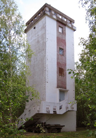
1936. Inactive since 1982. Approx. 30 m (98 ft) square pyramidal skeletal tower with lantern and gallery, originally painted white. Google has a satellite view. The light was replaced by a mast light, probably due to a change in the range line. Sometime around 1990 (probably in 1988) the light was moved to the top of a historic daybeacon (next entry). Located on the northwestern corner of Ulkokrunni island in the Krunni archipelago, about 20 km (12.5 mi) west of the mainland and 40 km (25 mi) northwest of Oulu. The island is a natural preservation area; landing is prohibited unless authorized by the Maakrunni Society. Accessible only by boat. Site and tower closed.
Ulkokrunni Range Rear (3)
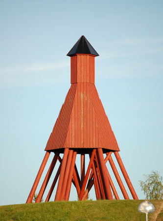
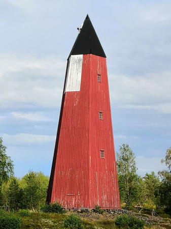
1874 (unlit until recent years). Active; focal plane 26.5 m (87 ft); one long white flash every 8 s in a sector towards the range. Approx. 29.6 m (97 ft) hexagonal wooden tower with pyramidal roof. Tower painted red with a rectangular white daymark at the top. Trabas has Teemu Vehkoaja's photo seen at right and Bing has a satellite view. One of several historic daybeacons in service in northern Finland. Formerly in dilapidated condition, it was restored in 1988; the light may well have been added at this time. Located on the northeastern tip of Ulkokrunni island. Accessible only by boat. Site and tower closed. SU-8890; Admiralty C4101.1; NGA 18780.
Maakrunni Range Rear
Date unknown. Active; focal plane 30.5 m (100 ft); white light, 2 s on, 4 s off. Approx. 28 m (92 ft) slender square skeletal tower carrying a large rectangular daymark painted yellow with a red vertical stripe. Trabas has Teemu Vehkaoja's photo and Google has a satellite view. The range guides southbound vessels. The front light is on a similar, much smaller tower. Located on the southeastern tip of Maakrunni, a large island about 10 km (6 mi) east northeast of Ulkokrunni. Accessible only by boat. Site and tower closed. SU-9134; Admiralty C4102.1; NGA 18788.
Pohjanletto Range Rear
Date unknown. Active; focal plane 31 m (102 ft); white light, 2 s on, 6 s off. 31 m (102 ft) slender square skeletal tower carrying a large rectangular daymark painted yellow with a red vertical stripe. No photo available and Bing has only a fuzzy satellite view. The range guides northbound vessels past Ulkokrunni. The front light is on a similar, much smaller tower. Located about 2.5 km (1.5 mi) north of Ulkokrunni. Accessible only by boat. Site open, tower closed. SU-8894; Admiralty C4103.1; NGA 18789.1.
Pohjanletto
Date unknown. Active; focal plane 12 m (39 ft); three quick white flashes every 5 s. 12 m (39 ft) round concrete tower painted black with one yellow horizontal band. No photo available and the light is not seen in Bing's satellite view. This light marks a sharp turn in the shipping channel between Oulu and Kemi. Located about 8 km (5 mi) north northeast of Ulkokrunni. Accessible only by boat. Site open, tower closed. SU-11136; Admiralty C4102.5; NGA 18788.5.

Ulkokrunni Range Rear Light, Ii
photo copyright Teemu Vehkoaja; used by permission

Information available on lost lighthouses:

Notable faux lighthouses:

Adjoining pages: North: Lappi | South: Ostrobothnia

Return to the Lighthouse Directory index | Ratings key

Posted October 8, 2007. Checked and revised October 15, 2023. Lighthouses: 41. Site copyright 2023 Russ Rowlett and the University of North Carolina at Chapel Hill.