Lighthouses of Guadeloupe

Guadeloupe is an overseas département of France located in the northern part of the Lesser Antilles, the curving chain of islands at the eastern end of the Caribbean Sea. The two main islands of Guadeloupe together are shaped remarkably like a butterfly. The two wings of the butterfly, Grande-Terre island to the east and Basse-Terre to the west, are nearly joined by a narrow isthmus crossed by a even narrower channel. Also included in the département are the nearby islands of Marie Galante, La Désirade, Petite-Terre, and Les Saintes.

France colonized Guadeloupe as early as 1635 and has held the territory since except for interruptions by British invasions during the Seven Years War and the Napoleonic Wars. As an overseas department Guadeloupe is legally part of France; it is included in the European Union and uses the euro as its currency.

French is the official language in Guadeloupe and is widely spoken, along with a French-based creole dialect. The French word for a lighthouse is phare, although a smaller light or harbor light is called a feu (literally "fire," but here meaning "light") or a balise (beacon). In French île is an island, cap is a cape, pointe is a promontory or point of land, roche is a rock, récife is a reef, baie is a bay, estuaire is an estuary or inlet, détroit is a strait, rivière is a river, and havre is a harbor.

Aids to navigation in Guadeloupe are operated by the Grand Port Maritime de la Guadeloupe, the local port authority, also called Guadeloupe Port Caraïbes.

ARLHS numbers are from the ARLHS World List of Lights. Admiralty numbers are from volume J of the Admiralty List of Lights & Fog Signals. U.S. NGA numbers are from Publication 110.

General Sources
Online List of Lights - Guadeloupe
Photos by various photographers posted by Alexander Trabas. Most of the Guadeloupe photos are by Capt. Peter Mosselberger ("Capt. Peter").
Lighthouses in Guadeloupe
Photos by various photographers available from Wikimedia.
World of Lighthouses - Guadeloupe
Photos by various photographers available from Lightphotos.net.
Phares d'Amérique
This page, part of Alain Guyomard and Robert Carceller's site Le Phare à travers le monde, links to several photos of the lighthouses of Guadeloupe.
France: Guadeloupe
Historic postcard images posted by Michel Forand.
Leuchttürme Mittelamerikas und der Karibik auf historischen Postkarten
Historic postcard images posted by Klaus Huelse.
GPSNauticalCharts
Navigation chart for Guadeloupe.
Navionics Charts
Navigation chart for Guadeloupe.

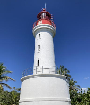
Îlet du Gosier Light, Pointe-à-Pitre, Seotember 2018
Instagram photo by oc.foto posted by IG Guadeloupe
Northern Grande-Terre Lighthouses
* Port Louis
Date unknown (station established 1886). Active; focal plane 10 m (33 ft); nine quick white flashes every 15 s. 10 m (33 ft) square concrete skeletal tower with enclosed lower section. Lighthouse painted yellow with a black horizontal band. Trabas has Capt. Peter's photo, Rolf Kamras has a closeup photo, and Google has a satellite view. Located on Rue de la Liberté at the base of a short pier in Port Louis, a small port on the west side of the northern peninsula of Grande-Terre. Site open, tower closed. Admiralty J5716; NGA 14836.
* Anse Bertrand
Date unknown. Active; focal plane 14 m (46 ft); two flashes every 6 s, white, red or green depending on direction. 8 m (26 ft) square concrete skeletal tower with enclosed lower section. Lighthouse painted white. Trabas has Capt. Peter's photo, Bashkim Hazizaj has a 2023 photo, and Google has a street view and an indistinct satellite view. Located on the waterfront of Anse Bertrand, near the northern tip of Grande-Terre. Site open, tower closed. Admiralty J5718; NGA 14840.
Le Moule (Port du Moule)
Date unknown (station established 1858). Active; focal plane 12 m (39 ft); quick-flashing light, white or red depending on direction. 11 m (36 ft) square concrete skeletal tower with enclosed lower section. Lighthouse painted white with a red top. Trabas has Capt. Peter's photo, Edyta Morawska has a 2023 photo, Google has a drone view, a closeup street view and a satellite view. Located on the west side of the entrance to Le Moule, a small port and resort town on the northeast coast of Grande-Terre. Site status unknown. Admiralty J5722; NGA 14844.
* Le Moule (Port du Moule) Est
Date unknown. Active; focal plane 7 m (23 ft); two flashes every 6 s, white, red or green depending on direction. 7 m (23 ft) square concrete quadrupod tower with enclosed lower section. Lighthouse painted white with a green top. Trabas has Capt. Peter's photo and Google has a drone view and a satellite view. Located on the east side of the entrance to Le Moule. Site open, tower closed. Admiralty J5723; NGA 14848.

Île de la Désirade Lighthouse
* La Désirade (Pointe Doublé) (2)
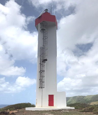
Date unknown (modern; station established 1933). Active; focal plane 50 m (164 ft); two white flashes every 10 s. 20 m (66 ft) triangular cylindrical concrete tower with a hexagonal gallery. The light is displayed from a pedestal atop the gallery. There is an enclosed equipment room at the base of the tower, but access to the gallery is by an external ladder. Tower painted white, gallery and pedestal painted red. A photo by Nathalie Bordy and François Barthélemy is at right, Trabas has Capt. Peter's photo, a 2007 photo is available, Bernardo Simu has a 2023 photo, Alix Briot Joseph has a street view, and Google has a satellite view. Forand has a postcard view of the original lighthouse, a cast iron skeletal tower with lantern and gallery. Located at Point Doublé, the eastern end of the island of La Désirade, which is east of the main island of Guadeloupe. The lighthouse is accessible by road; La Désirade is accessible by air or by ferry from Saint-François on Grande-Terre. Site open, tower closed. ARLHS GUA-005; Admiralty J5724; NGA 14812.
Phare de la Désirade
Pointe Doublé Light, La Désirade
September 2009
Wikimedia Creative Commons photo
by Nathalie Bordy and François Barthélemy

Petite-Terre Lighthouse
Petite-Terre
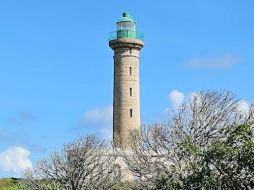
1840. Active; focal plane 33 m (108 ft); 3 white flashes every 12 s. 26 m (85 ft) round brick tower with lantern and gallery, rising from a square 1-story stone keeper's house. Tower unpainted, lantern painted green. Stanko Rusnák's photo is at right, Trabas has Capt. Peter's photo, Patrick Bantigny has a 2020 photo, a closeup is available, there's a page for the lighthouse with several photos, Christophe Hamieau has a distant view, and Google has a satellite view. This is the oldest lighthouse in the Antilles and it served for many years as the landfall light for Guadeloupe. The lighthouse was modernized in 1934 and again in 1965; it appears to be well preserved today although it is rarely visited. It was recognized as a historic monument in 2002. The Îles de la Petite-Terre are two small islands southeast of Guadeloupe; the lighthouse is on the larger island, called Terre de Bas. It has been uninhabited since the lighthouse was automated in 1972. Located at the eastern end of the island. The lighthouse is visible distantly from Pointe des Châteaux at the easternmost tip of Grand-Terre. Accessible only by boat; tours available from Saint-François on Grande-Terre. The island is a nature reserve and a permit is required to land there. Site and tower closed. Site manager: Réserve Naturelle Îles de la Petite-Terre. . ARLHS GUA-006; Admiralty J5730; NGA 14832.

Southern Grande-Terre Lighthouses
[Port de Saint François]
Date unknown. Active; focal plane 10 m (33 ft); quick-flashing light, white, red or green depending on direction. Approx. 6 m (20 ft) post rising from a square enclosure. Entire lighthouse is white. Trabas has Capt. Peter's photo and Google has an indistinct satellite view. Located on the aterfront of Saint François, town on the south coast of Grande-Terre. Site status unknown. Admiralty J5731; NGA 14852.

Petite-Terre Light, January 2016
Google Maps photo by Stanko Rusnák
* Îlet du Gosier (3)
1928 (station established 1852). Active; focal plane 24 m (79 ft); two red flashes every 10 s. 21 m (69 ft) round brick tower with lantern and gallery, rising from the center of a circular workroom; the red navigation beacon is now mounted above the lantern. Tower painted white, lantern and gallery bright red. Keyne Charlot's photo appears at the top of this page, Trabas has Capt. Peter's closeup photo, Guyomard and Carceller have many photos, Wikimedia has a photo, Brayan Alejandro Puerta Caceres has a 2022 photo, another photo is available, Marinas.com has aerial photos, Huelse has a historic postcard view, Forand has another postcard view, Francois and Pam Belorgey have a closeup street view, and Google has a satellite view. Geoff Schultz has a photo of the lighthouse freshly repainted in 2001. The original lighthouse was replaced in 1882; both of the first two lighthouses were replaced due to damage from hurricanes. Located on a small island about 100 meters offshore from Gosier and 5 km (3 mi) south of Pointe-à-Pitre. Accessible only by boat. Site open; visitors can climb to the observation level atop the workroom. . ARLHS GUA-001; Admiralty J5734; NGA 14860.
* Pointe-à-Pitre Range Front (Îlet à Monroux)
Date unknown (station established 1858). Active; focal plane 15 m (49 ft); quick-flashing white light, intensified on the range line. 14 m (46 ft) square skeletal tower, painted white. The tower also carries a white, horizontally-slatted daymark. Trabas has Capt. Peter's photo and Google has a distant satellite view. Located on the Monroux peninsula on the east side of the entrance to Pointe-à-Pitre, a major seaport with a population of about 300,000. Site open, tower closed. Admiralty J5736; NGA 14864.
* [Pointe-à-Pitre Range Rear (Pointe Fouillole)]
Date unknown (station established 1883). Active; focal plane 21 m (69 ft); quick-flashing white light. 20 m (66 ft) square steel mast, painted white with a green top; a narrow stairway spirals around the mast. The tower also carries a white, horizontally-slatted daymark. Trabas has Capt. Peter's photo and Google has a satellite view. Located on Pointe Fouillole, 640 m (0.4 mi) north northwest of the front light. Site open, tower closed. Admiralty J5736.1; NGA 14868.

Basse-Terre Lighthouses
* Trois-Rivières
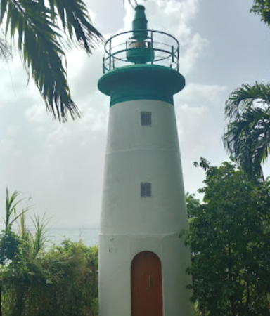
Date unknown. Active; focal plane 25 m (82 ft); alternating red, green, and white light, 2 s on, 2 s off. 9 m (29 ft) round masonry tower with gallery, painted white with a green band at the top. The lighthouse has a small gallery, but no lantern. Trabas has Capt. Peter's closeup photo (also seen at right) and Google has a sea view and a fuzzy satellite view. Trois-Rivières is a small port on the southeast coast of Basse-Terre about 11 km (7 mi) east of Vieux-Fort. Located just off the Chemin de Morne-Rouge, on a bluff above the north side of the harbor of Trois-Rivières. Site open, tower closed. ARLHS GUA-010; Admiralty J5702; NGA 14880.

Trois Rivières Light, Trois Rivières
photo copyright Capt. Peter Moselberger; used by permission
* Vieux-Fort
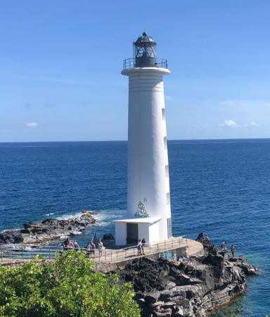
1955. Active; focal plane 26 m (85 ft); two white flashes, 6 s off, one white flash, 6 s off. 23 m (75 ft) round concrete tower with lantern and gallery. The lighthouse is painted white; the lantern is gray. A 2023 photo is at right, Trabas has Capt. Peter's closeup, Wivina Rella has a 2021 photo, Guyomard and Carceller have photos by Gilles Dhordain, Guillaume Laforge has a fine photo, Huelse has a historic postcard view, Forand also has a postcard view, and Google has a street view and a satellite view. Accessible by road; parking is limited. Located at the southwestern tip of the island, with popular gardens nearby. Site open, tower closed. . ARLHS GUA-007; Admiralty J5704; NGA 14888.
* [Basse-Terre Quay]
Date unknown. Active; focal plane 14 m (46 ft); flash every 4 s, white or green depending on direction. 12 m (39 ft) square skeletal mast with a small equipment cabinet in the base. Tower painted white. Trabas has Capt. Peter's closeup photo and Google has a closeup street view and an indistinct satellite view. Located on the quay at Basse-Terre city. Site open, tower closed. Admiralty J5706; NGA 14884.
* Anse à la Barque (2)
Date unknown (station established 1886). Active; focal plane 11 m (36 ft); two flashes, alternating two red, two green, and two white, every 6 s. 9 m (30 ft) round masonry tower, painted white. The lighthouse has a small gallery but no lantern. Trabas has Capt. Peter's photo, Claude Roussel-Dupre has a photo, Kristin Schümann has a 2022 photo, a good closeup is available, and Google has a street view and a satellite view. The light is adjacent to a diving club. Located in a small bay about 10 km (6 mi) north of Basse-Terre on the west side of the island. Accessible by road and parking is available. Site open, tower closed. Site manager: Le Centre de Plongée des Îlets. . Admiralty J5712; NGA 14892.
* Pointe de la Barque (Pointe de l'Anse)
Date unknown. Active; focal plane 28 m (92 ft); nine quick white flashes every 15 s. 7 m (23 ft) square cylindrical concrete tower with enclosed equipment room. Tower painted white; until recently it was painted bright yellow with one narrow horizontal black band. László Valusek has a 2020 photo, Trabas has Capt. Peter's closeup photo, Matthias Burch has a 2008 photo, and Google has an indistinct satellite view. Located on the point enclosing the north side of Anse à la Barque. Accessible by road; parking is limited. Site open, tower closed. ARLHS GUA-002; Admiralty J5710; NGA 14896.

Vieux-Fort Light, Vieux-Fort, April 2023
Instagram photo by Oli

Île des Saintes Lighthouse
* Bourg des Saintes (Port des Saintes) (2)
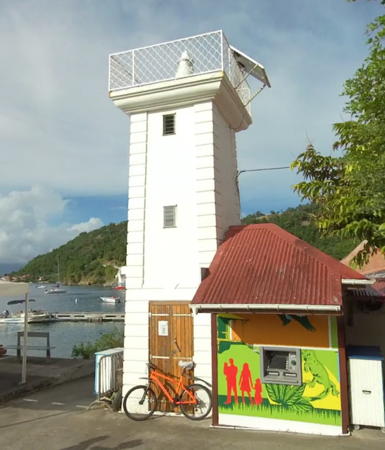
Date unknown (station established 1935). Active; focal plane 9 m (30 ft); flash every 4 s, white, red, or green depending on direction. 8 m (26 ft) square cylindrical masonry tower with gallery but no lantern, painted white. Wikimedia's closeup by Stéphane Batigne is at right, Guyomard and Carceller have posted a photo by Yves Conne, Trabas has Capt. Peter's photo, Lightphotos.net has a photo, and Vincent Pascal has a a closeup street view, and the tower is crowded among other buildings in Google's satellite view. The Îles des Saintes are small islands located about 20 km (13 mi) south of Basse-Terre, Guadeloupe. Located at the foot of the wharf in Bourg des Saintes, the only town in the islands. Site open, tower closed. ARLHS GUA-011; Admiralty J5746; NGA 14904.

Marie-Galante Lighthouses
Marie-Galante is an island about 15 km (9 mi) in diameter, located about 20 km (13 mi) southeast of Basse-Terre. The island has a population of about 11,000.

*
Capesterre Range Front
Date unknown. Active; focal plane 12 m (39 ft); quick-flashing red light. 7 m (23 ft) square cylindrical white concrete skeletal tower, lower portion enclosed, painted with red and white horizontal bands on the seaward side. Trabas has Luc Petrelluzzi's photo and Google has a satellite view. Located beside the Rue de la Marine on the north side of Capesterre, a village on the southeast side of the island. Site open, tower closed. Admiralty J5752; NGA 14916.
* Capesterre Range Rear
Date unknown. Active; focal plane 16 m (52 ft); quick-flashing red light. 6 m (20 ft) square cylindrical white concrete skeletal tower, lower portion enclosed, painted with red and white horizontal bands on the seaward side. Trabas has Luc Petrelluzzi's photo and Google has a satellite view. Located 100 m (90 yd) northwest of the front light (a street connects the two lights). Site open, tower closed. Admiralty J5752.1; NGA 14920.
* Saint-Louis
Date unknown (station established 1930). Active; focal plane 11 m (36 ft); green flash every 4 s. 9 m (30 ft) square cylindrical masonry tower with gallery but no lantern. The upper 1/4 of the tower is painted green and the rest white. Trabas has Capt. Peter's photo and Bing has a distant satellite view. Located at the north end of the waterfront of Saint-Louis on the northwest coast of the island. Site open, tower closed. ARLHS GUA-009; Admiralty J5750; NGA 14912.

Bourg des Saintes Light, January 2011
Wikimedia Creative Commons photo by Stéphane Batigne

Information available on lost lighthouses:

Notable faux lighthouses:

Adjoining pages: North: Antigua and Barbuda | South: Dominica

Return to the Lighthouse Directory index | Ratings key

Posted December 8, 2005. Checked and revised February 1, 2024. Lighthouses: 15. Site copyright 2024 Russ Rowlett and the University of North Carolina at Chapel Hill.