Lighthouses of Grenada

Grenada is an independent British Commonwealth Realm at the southern end of the Windward Islands of the West Indies, located south of Saint Vincent, southwest of Barbados, and north of Trinidad and Tobago. Although it was colonized initially by the French Grenada was a British colony from 1762 until it achieved independence in 1974. The country includes the large island of Grenada itself and also the southern third of the Grenadines, a chain of small islands between Saint Vincent and Grenada.

After the historic Point Saline Light was demolished in the early 1980s the country had no active traditional lighthouses except for the very small Fort George beacon. This has changed recently with the building of a private lighthouse at Prickly Point. In addition, Grenada has several other sites of interest to lighthouse fans, including a Swedish lightship in retirement as a marina restaurant.

Navigational aids in Grenada are maintained by the Grenada Ports Authority.

ARLHS numbers are from the ARLHS World List of Lights. Admiralty numbers are from volume J of the Admiralty List of Lights & Fog Signals. U.S. NGA List numbers are from Publication 110.

General Sources
Online List of Lights - Grenada
Photos by various photographers posted by Alexander Trabas.
World of Lighthouses - Grenada
Photos by various photographers available from Lightphotos.net.
Leuchttürme Mittelamerikas und der Karabik auf historischen Postkarten
Historic postcard views posted by Klaus Huelse.
GPSNauticalCharts
Navigational chart for Grenada.
Navionics Charts
Navigational chart for Grenada.


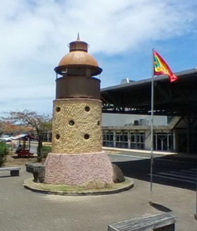
Point Saline lantern at airport entrance, Grenada,
Google Maps street view by Nelson Garcez

Lightship
*** Swedish Lightship 23 Västra Banken
1901 (Bergsunds Mekaniska Verkstad, Stockholm). Decommissioned 1970. 28 m (89 ft) steel lightship. The original superstructure of the ship was removed and is on display at a museum in Öregrund, Sweden; the ship now carries a modern superstructure and the light tower taken from lightship 21 Trelleborgs Redd. The light tower is placed near the stern; the original was amidships. Hull painted red, superstructure white, lantern blue. Kevin Chatar has a 2019 photo of the ship at its new home in Grenada, Steve Brett has a closeup, Lightphotos.net has a photo, Thomas Karrer has a street view, and Google has a satellite view. From 1923 to 1970 the lightship served on the Västra Banken station in the Baltic Sea off Gävle, Sweden, north of Stockholm. After deactivation the lightship was sold as a restaurant. In 1999 it was sold again and moved to Stockholm as a houseboat. In November 2005 it was sold a third time, to developers of a marina and resort in Grenada. The ship was towed to Rostock, Germany, to be restored and re-equipped. It was then loaded on the MV Schippersgracht and carried to the West Indies, arriving at the new marina in December 2006. The ship was opened as a restaurant and conference center in June 2007. Located at Le Phare Bleu Marina on the south coast of Grenada, 5.5 km (3.5 mi) southeast of St. George's. Site open; ship open daily. Owner/site manager: Le Phare Bleu Marina and Resort. Formerly ARLHS SWE-256.

Lighthouses
* Prickly Point (L'Anse aux Épines)
Date unknown (modern). Active (privately maintained); focal plane about 30 m (98 ft); continuous red light. Approx. 10 m (33 ft) round tower with an observation room, topped by a mast. Lighthouse painted light green. Jennifer Lyons has a 2018 photo (also seen at right), Luca Patriccioli has a photo, Bob Hall has a closeup, Brian Marsh has a street view, and Google has a satellite view. Located at Prickly Point, the southern tip of Grenada. Site and tower closed (private property), but the lighthouse can be seen from nearby. Owner/site manager: private. Admiralty J5830.3; NGA 15161.

Prickly Point Light, Grenada, August 2018
ex-Google Plus photo by Jennifer Lyons
* [Pointe Saline (lantern)]
1904. Inactive since the early 1980s. Huelse has a postcard view of the original lighthouse, an 8.5 m (28 ft) steel post supporting a lantern and gallery. In 1932 the lantern was transferred to the top of a 15 m (49 ft) concrete (?) tower painted with black and white horizontal bands. A 1970s photo (halfway down the page) of the 1932 lighthouse is available and Huelse also has a postcard view of that lighthouse. Sadly, the light was deactivated and the tower demolished in the early 1980s. The lantern is now displayed at the nearby international airport. Part of a street view by Nelson Garcez is at the top of this page and the short shadow of the lighthouse is visible at the airport entrance in Google's satellite view. There is a very small beacon (Admiralty J5830.7; NGA 15164) at the original location. Site open. Owner/site manager: Maurice Bishop International Airport. ARLHS GRD-002.
Petits Cabrits
Date unknown. Active; focal plane 108 m (354 ft); three white flashes, in a 2+1 pattern, every 20 s. Approx. 7 m (23 ft) skeletal tower mounted on a square 1-story equipment building. Trabas has Rainer Arndt's photo and Google has an indistinct satellite view. This is the landfall light for the island. Located on a headland about 4 km (2.5 mi) southwest of St. George's. Site status unknown. Admiralty J5830.2; NGA 15174.
* St. George's Harbour Range Rear
Date unknown. Active; focal plane 28 m (92 ft); continuous red light. Approx. 15 m (49 ft) square skeletal tower carrying a rectangular daymark colored orange with a white vertical stripe. Ricky Thomas has a 2024 street view, Trabas has Arno Siering's distant photo, and Google has an indistinct satellite view. This is the approach range for the harbor. The front light is on a similar tower at the water's edge. Located beside Ross Point Road south of the harbor. Site open, tower closed. Admiralty J5834.3; NGA 15177.1.
* St. George's Harbour (Fort George)
1890s. Inactive at least since 2017. 4 m (15 ft) octagonal cylindrical brick tower mounted on the battlements of Fort George, a French fort built in 1707. Neal Doan's photo is at right, Bernd Claußen has photos, Lightphotos.net has a photo, Trabas has a photo by Arno Siering, and Peter Steiner has a street view, but the small building is hard to see in Google's satellite view of the fort. A Fresnel lens, probably fifth order, was formerly mounted in the tower but has been removed, we hope for safekeeping. Doan visited the fort in November 2010 and found the structure to be in poor condition. Located on the north side of the entrance to the harbor of St. George's, the capital of Grenada. Site and tower apparently open. Site manager: Government of Grenada. ARLHS GRD-001; ex-Admiralty J5834; ex-NGA 15176.

Information available on lost lighthouses:

Notable faux lighthouses:

Fort George Light
St. George's Harbour Light, Fort George, November 2010
photo copyright Neal Doan; used by permission

Adjoining pages: North: St. Vincent and the Grenadines | South: Trinidad and Tobago

Return to the Lighthouse Directory index | Ratings key

Posted December 8, 2005. Checked and revised February 24, 2024. Lighthouses: 4; lightships: 1. Site copyright 2024 Russ Rowlett and the University of North Carolina at Chapel Hill.