Lighthouses of China: Hong Kong

The People's Republic of China (PRC), known officially as Zhōnghuá (中华), has a lengthy coastline, many large harbors, and a large number of lighthouses. The country is divided into 23 provinces and 11 other province-level regions of various special types.

Hong Kong is a territory surrounded by Guangdong province on the south coast of China. The territory includes Hong Kong Island, the Kowloon Peninsula facing Hong Kong Island, Lantou Island, and many other surrounding islands. British troops occupied Hong Kong Island in 1841 and the island was ceded to Britain the following year. Additional territory was ceded in 1860 and in 1898 the British obtained a 99-year lease on the remaining parts of the territory. All of Hong Kong was returned to Chinese control when that 99-year lease expired in 1997.

Since 1997 Hong Kong has been a province-level Special Administrative Region (SAR) of China with an autonomous government. Although it is definitely part of China, Hong Kong functions in certain respects as if it were a separate country. A financial center and one of the world's great ports, Hong Kong has a population of approximately 7.5 million.

Aids to navigation in Hong Kong are maintained by the Hong Kong SAR Marine Department. The five historic lighthouses are well known but less is known about smaller lights.

Both Chinese and English are official languages in Hong Kong. In the Yue (Cantonese) dialect spoken in Hong Kong, tsui is a cape, chau is an island, and kong is a harbor ("Hong Kong" means "Fragrant Harbor"). Due to competing systems for transliterating Chinese and related dialects into Latin characters, there are always several possible spellings for the names of places in China.

Special thanks to Matthew Yuen for sharing his research on the history of Hong Kong lighthouses.

ARLHS numbers are from the ARLHS World List of Lights. HK numbers are the SAR Marine Department's light list numbers; these numbers are painted or displayed on the light towers. Admiralty numbers are from volume P of the Admiralty List of Lights & Fog Signals. NGA numbers are from NGA Publication 112. The Maritime Department does not publish its list of lights.

General Sources
Lighthouses in Hong Kong
Information on several of the historic lighthouses provided by Wikipedia.
Lighthouses in Hong Kong
Photos by various photographers available from Wikimedia.
World of Lighthouses - Hong Kong
Photos by various photographers available from Lightphotos.net.
Online List of Lights - China
Photos by various photographers posted by Alexander Trabas. The majority of the Hong Kong photos are by Ricky Wong or Matthew Yuen.
HK Marine AtoN
Photos and notes by Matthew Yuen.
Hong Kong's Lighthouses and the Men Who Manned Them
Caution: large pdf file. This 40-page article by Louis Ha and Dan Waters (in English) provides interesting background on the early lighthouses of Hong Kong. Posted by the Hong Kong University Library.
Declared Monuments in Hong Kong
Information in English posted by the Hong Kong Antiquities and Monuments Office.
Hong Kong
Historic postcard views posted by Michel Forand.
Leuchttürme Chinas auf historischen Postkarten
Historic postcard images posted by Klaus Huelse.
Navionics Charts
Navigation chart for Hong Kong.


Green Island (Tsing Chau) Light, January 2021
Google Maps photo by Ben Lau

Tai Po District (Mirs Bay) Lighthouses
Mirs Bay (known as Tai Ping Wan or Dàpéng Wān in Chinese) is an roughly circular embayment on the northeast side of Hong Kong. The entire bay is within the borders of the Special Administrative Region but the eastern and northern coasts are in the mainland city of Shēnzhèn.

Ping Chau (Tung Ping Chau, Jimmy Head)
Date unknown. Active; focal plane 15 m (49 ft); three white flashes every 10 s. Approx. 5 m (17 ft) white concrete tower. A drone view is available and Google has a satellite view. Tung Ping Chau is an island in the northeastern corenr of Mirs Bay; most of the island is a county park. Located on a bluff on the southwestern tip of the island. Site status unknown. Admiralty P3578.5.
Chek Kok Tau (Crooked Island)
Date unknown. Active; focal plane 7 m (23 ft); white flash every 5 s. 5 m (16 ft) round white concrete tower mounted on a square concrete base. Edward Fung has a street view and Google has a satellite view. Located at the northwest point of Kat O (Crooked Island), an island in the northwestern corner of Mirs Bay opposite the port of Yantian. Probably accessible only by boat. Site open, tower closed. HK-065; Admiralty P3578.6.
Shek Ngau Chau
1972. Active; focal plane 26 m (85 ft); white flash every 4 s. 5 m (17 ft) square unpainted white concrete building with a short post light centered on the roof. Sunny Leung has a street view, a distant view from the sea is available, and Google has an indistinct satellite view. and an overhead drone view. Located atop the islet of Shek Ngau Chau in the entrance to the bay. Accessible only by boat. Site open, tower closed. HK-103; Admiralty P3578.3; NGA 19292.

Sai Kung District Lighthouses
The Sai Kung District is on the southeast edge of the New Territories (mainland) portion of Hong Kong, between Mirs Bay and the Eastern Entrance.

Wong Mau Chau (South Gau, Huangmao Zhou)
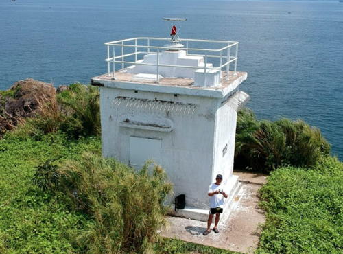
Around 1977. Active; focal plane 23 m (75 ft); red flash every 5 s. 5 m (17 ft) square unpainted white concrete building with a short post light centered on the roof. A drone view is at right, Kason Tsui has a 2022 closeup, Sunny Leung has a street view, and Google has a satellite view. Located on an islet off the Sai Kung East Country Park. Accessible only by boat. Site open, tower closed. HK-118; Admiralty P3578.4; NGA 19296.
Fan Tsang Chau (Conic Island)
Around 1978. Active; focal plane about 10 m (33 ft); two white flashes every 6 s. 7 m (23 ft) round concrete tower mounted on a square concrete base. Entire lighthouse is unpainted white concrete. Chung Kwong Lee has a photo, Wikimedia has a photo, Chi Tin Fung has a distant view, and Google has an indistinct satellite view. Fan Tsang Chau is a steep island just off the southeastern tip of the Sai Kung Peninsula. Located on the northern tip of the island, marking the narrow passage between the island and the mainland. Accessible only by boat. Site open, tower closed. HK-178; Admiralty P3580.95; NGA 19300.

Wong Mau Chau Light, Mirs Bay, September 2017
Google Maps drone view by Dàfū
Pak Kwo Chau (North Ninepin Island)
1979. Active; focal plane 35 m (115 ft); flash every 10 s, white or red depending on direction. 5 m (17 ft) square unpainted white concrete building with a short post light centered on the roof. A closeup is available, Trabas has Wong's distant view, Sunny Leung has a street view, and Google has a satellite view. Ninepin Island seems to have gotten its name from its shape. Located at the northeastern end of the island, about 10 km (6 mi) northeast of Waglan Island. Accessible only by boat; there is a pier and a trail to the lighthouse, and it appears that many people visit the site. Site open, tower closed. HK-200; Admiralty P3575.6; NGA 19334.
Fat Tong Mun (Tung Lung Chau North)
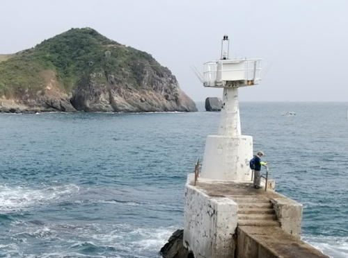
Date unknown. Active; focal plane 9 m (30 ft); white flash every 5 s. 5 m (16 ft) round white concrete tower mounted on a square concrete base and standing on a concrete pedestal. Trabas has Wong's photo, Elvira Laguit has the 2020 photo seen at right, and Google has a satellite view. Located on the northern tip of Tung Lung Chau, marking the narrow passage between that island and the mainland. Site open, tower closed. HK-184; Admiralty P3574.5.
Lam Tong Mei (Tathong Point, Nam Tong Mei, Tung Lung Chau) (2?)
1966 (station established 1921). Active; focal plane 56 m (184 ft); three flashes every 10 s. 2 m (7 ft) post light standing beside a 1-story building. Ricky Wong has a 2018 photo, another photo shows the rear of the building, Trabas also has a photo by Wong, a 2023 photo is available, and Google has a satellite view. The original lighthouse was on a different location; the present station is built atop a former Japanese gun emplacement. Located on Tathong Point at the southern tip of Tung Lung Chau, marking the east side of the entrance to the Tathong Channel. Site and tower closed. HK-092; Admiralty P3574; NGA 19342.
Nga Ying Pai
Date unknown. Active; focal plane 12 m (39 ft); white flash every 1.5 s. 5 m (16 ft) round white concrete tower mounted on a round concrete base. Trabas has Wong's closeup photo, Toni Shiu has a 2024 view from the sea, and Google has a satellite view. Located on a rocky islet off the southwest coast of Tung Lung Chau. Accessible only by boat. Site open, tower closed. HK-091; Admiralty P3573.6; NGA 19352.

Fat Tong MUN Light, Sai Kung, January 2020
Google Maps photo by Elvira Laguit
Fat Tong Chau (Junk Island)
Date unknown. Active; focal plane 20 m (66 ft); two white flashes every 6 s. 5 m (16 ft) round white concrete tower mounted on a round concrete base. Trabas has Wong's closeup photo, Andreas Köhler has a photo, Cyril Ha has a 2022 drone view, and Google has a satellite view. Located on a rocky islet off a promontory directly opposite the Cape Collison Light (see below). Accessible only by boat. Site open, tower closed. HK-148; Admiralty P3573; NGA 19358.
 

Hong Kong Island: Eastern District Lighthouses
* A Kung Ngam (Eastern Fairway) (2)
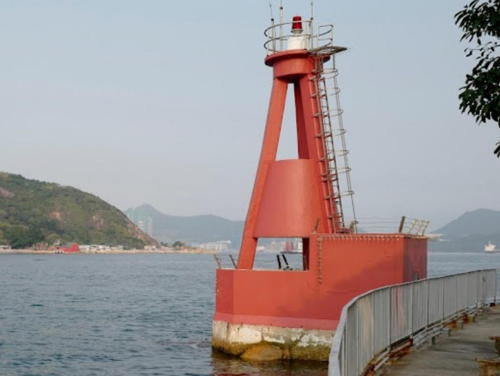
1964 (station established 1924). Active; focal plane 11 m (36 ft); red flash every 5 s. 8 m (26 ft) concrete tripod mounted on a square 1-story concrete equipment building. Entire lighthouse painted red. Cheuk Cheng has a 2019 photo (seen at right), Lorien Ali has a good 2017 photo, Bronney Hui has a photo, Trabas has Wong's closeup photo, Charman To has a closeup street view, and Google has a street view and a satellite view. A daybeacon was placed here in 1902. The first light, in 1924, was on a 2.7 m (9 ft) pillar. Located on a promontory at the northeast corner of Hong Kong Island, marking a narrow passage around the island. Site open, tower closed. HK-089; Admiralty P3570; NGA 19370.
* Hak Kok Tau (Heijiao Tou, Cape Collinson) (3?)
1966 (station established 1876). Active; focal plane 50 m (164 ft); two flashes every 10 s, white or red depending on direction. The light is mounted on a square equipment room atop a 2-story building. Ken Wong has a closeup photo, Trabas has Ricky Wong's photo, Nel Chan has a 2022 photo, Johnny Wong has an aerial photo, and Google has a satellite view. One of the three earliest British light stations of Hong Kong. Located on a promontory at the eastern end of Hong Kong Island. Accessible by a short hike from Siu Sai Wan Park, but the lighthouse itself is fenced. ARLHS HOK-007; HK-090; Admiralty P3572; NGA 19355.

A Kung Ngam (Eastern Fairway) Light, Hong Kong Island, March 2019
Google Maps photo by Cheuk Cheng

Islands District: Po Toi Islands Lighthouses
The Po Toi Islands are a group of small islands off Cape D'Aguilar, the southeastern tip of Hong Kong Island.
Waglan Island (Wang Lan To)
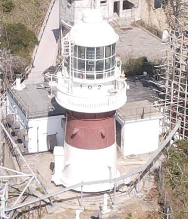
1893 (David Marr Henderson). Active; focal plane 69 m (226 ft); two white flashes every 20 s. 16 m (52 ft) round cast iron tower with lantern and gallery, painted white with a red horizontal band under the gallery. Fog horn (two blasts every 60 s). Keeper's house and numerous other station buildings; the station has had a number of uses over the years and is the site of meteorological observations today. Kit Kuen Cao's 2021 photo is at right, Samuel Li has a 2022 photo, Felix Fung has a 2007 photo, Andie Wong has a view from the sea, Trabas has Ricky Wong's distant photo, Huelse has a historic postcard view, Forand has a different postcard view, and Google has a satellite view. This lighthouse is a landfall light for vessels arriving in Hong Kong from the east. Ordered by Chinese authorities and prefabricated in France by Barbier, Bénard et Turenne, the lighthouse was transferred to British control in 1901. The light station was heavily damaged during World War II but the lighthouse survived intact. The station was recognized as a Hong Kong Declared Monument in 2000. In 2009 the 4th order clamshell Fresnel lens used in the lighthouse after World War II was donated for display at the Hong Kong Maritime Museum. Waglan Island is a rocky ridge breaking the sea about 5 km (3 mi) southeast of Cape D'Aguilar. Located at the highest point of the island, near the southwest end. Accessible only by boat. Site and tower closed. ARLHS HOK-005; HK-102; Admiralty P3578; NGA 19326.
* Po Toi (Poi Toi) Island
1970. Active; focal plane 67 m (220 ft); two white flashes every 10 s. Approx. 6 m (20 ft) square 1-story masonry or concrete equipment building with gallery, mounted on a stepped platform. Lighthouse painted white. Junhong Ye has a closeup photo, Luica Mak has a photo, Wikimedia has a 2010 photo, Google has a street view, and Bing has a satellite view. Po Toi is an island about 5 km (3 mi) due south of Cape D'Aguilar. The island is accessible by passenger ferry and is popular with hikers and birders. The light is accessible by a hiking trail, although many steps are required to climb to the lighthouse. Located on the southern tip of the island. Site open, tower closed. ARLHS HOK-006; HK-126; Admiralty P3576.6; NGA 19405.
Lo Chau (Luo Zhou, Beaufort Island)
1970. Active; focal plane 37 m (121 ft); flash every 3 s, white or red depending on direction. 8 m (26 ft) round white concrete post with gallery, mounted on a concrete base. A photo is available, Trabas has Wong's distant view and Google has a satellite view. Located on the northwestern tip of Lo Chau (Beaufort Island), a steep-sided island between Po Toi and Cape D'Aguilar. Site status unknown; access appears difficult. HK-125; Admiralty P3576.8; NGA 19415.
 

Waglan Island Light, Hong Kong, February 2021
Google Maps photo by Kit Kuen Cao

Hong Kong Island: Southern District Lighthouses
Tai Long Pai (Dalang Pai, Tathong Rock)
1964. Active; focal plane 14 m (46 ft); four red flashes every 15 s. 13 m (43 ft) concrete tripod tower. A 2018 photo and a drone view are available, Trabas has Wong's photo, Huelse has a historic postcard view, and Bing has an indistinct satellite view. Located on a rock in the Tathong (Tai Long) Channel about 3 km (2 mi) north of Cape D'Aguilar. Accessible only by boat. Site open, tower closed. HK-094; Admiralty P3575.4; NGA 19349.
* Cape D'Aguilar (Hok Tsui)
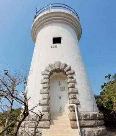
1875. Reactivated (inactive 1896-1975); focal plane 60 m (197 ft); white flash every 15 s. 9.7 m (32 ft) round stone tower with gallery, painted white. The lantern was removed long ago and the light is shown from a short post. Nearby buildings appear to be of modern origin; one of them is the Hong Kong University Institute of Marine Sciences. A 2023 photo is at right, Wikimedia has a 2013 photo, Andrew Chu has a closeup photo, Trabas has Wong's photo, Wikimedia has a view of the station, Kerchil Chan has a distant street view, and Google has a satellite view and a closeup street view. This is Hong Kong's oldest lighthouse. It became redundant after the Waglan Island lighthouse was placed in operation in 1893, but it was restored and reactivated in 1975 (its 100th anniversary). The original lantern and first-order lens were removed and installed on the Green Island lighthouse in 1905. The station was recognized as a Hong Kong Declared Monument in 2006. Cape D'Aguilar is the extreme southeastern tip of Hong Kong Island. Located at the end of Cape D'Aguilar Road. Site open, tower closed. . ARLHS HOK-001; HK-158; Admiralty P3576; NGA 19330.
Ngan Chau (Round Island)
Date unknown. Active; focal plane 28 m (98 ft); three flashes, white-red-white, every 10 s. Light atop a square 1-story white concrete building. Trabas has Wong's photo, Cammie Leung has a view from the sea, and Google has a satellite view. Located on the southern tip of Round Island, an island on the east side of the Western Entrance to Hong Kong harbor. Accessible only by boat. Site open, tower closed. HK-086; Admiralty P3577.1; NGA 19420.
Ap Lei Pai (Aberdeen Harbour, Mount Johnston)
Date unknown. Active; focal plane 8 m (26 ft); white flash every 15 s. 6 m (20 ft) round white concrete tower mounted on a square concrete base. Trabas has Wong's photo, S.K. Lau has a photo, a 2021 closeup is available, and Google has a satellite view. Aberdeen Harbour is a small boat harbor sheltered by the island of Ap Lei Chau. Located on an islet on the west side of the harbor entrance. Accessible only by boat. Site open, tower closed. HK-198; Admiralty P3577.68; NGA 19425.
Fo Yeuk Chau (Magazine Island)
1975. Active; focal plane 11 m (36 ft); white flash every 1.5 s. 11 m (36 ft) white concrete post light mounted on a round concrete base. Trabas has Wong's photo, a 2021 street view is available, and Google has a fuzzy satellite view. An earlier light (1960s?) was built on the disused explosives storage magazine on the island. Located on the west end of a small island off the southwest coast of Hong Kong Island. There should be a view of this light from the Wah Fu neighborhood to the north. Accessible only by boat. Site open, tower closed. HK-101; Admiralty P3577.6; NGA 19437.

Cape D'Aguilar (Hok Tsui) Light, March 2023
Frame from Instagram video by jean_jone

Hong Kong Island: Central and Western District Lighthouses
Green Island (Tsing Chau) (1)
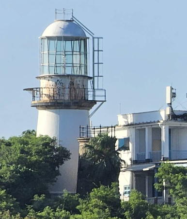
1875. Inactive since 1905. 12 m (39 ft) round granite tower with gallery, lantern removed. The lighthouse is unpainted. A photo of both towers is at the top of this page and a closeup of both towers is available. Originally equipped with a 4th order lens, the lighthouse was replaced because it was too small to carry the first-order lens that was ordered to be transferred from Cape D'Aguilar in 1905.
Green Island (Tsing Chau) (2)
1905 (station established 1875). Active; focal plane 37 m (121 ft); white flash every 10 s. 17.5 m (58 ft) round granite tower with lantern and gallery, painted white. 1st order Fresnel lens in use. The keeper's house and other light station buildings are leased to to the Wu Oi Christian Centre as a youth drug rehabiliation center. Ben Lau's 2021 drone view is at the top of this page, Trabas has Wong's photo, David Crawford has a 2008 photo, Wikimedia has a photo of both towers, Charman To has a 2018 drone view, a closeup of both towers is available, Forand has a historic postcard view, and Google has a satellite view. Green Island is a small island just off the northwestern tip of Hong Kong Island. The lighthouse was built to carry the 1st order lens made available when the Cape D'Aguilar lighthouse was replaced by the Waglan Island lighthouse. The Fresnel lens has been replaced in recent years by a modern LED light. The station was recognized as a Hong Kong Declared Monument in 2008. Located at the southwest point of Green Island, a small island off the west end of Hong Kong Island. Accessible only by boat; there are views from various ferries in Hong Kong Harbour. Site status unknown. ARLHS HOK-002; HK-069; Admiralty P3538; NGA 19460.
 

Sham Shui Po District Lighthouses
Naval Base Range Front
Date unknown. Active; focal plane 24 m (79 ft); quick-flashing white light. Square skeletal tower on the roof of a 3-story building. Trabas has Wong's photo and Google has a satellite view. This is the former British Royal Navy station, now operated by the Chinese Navy. The rear light (also seen in Wong's photo) is on a small skeletal tower on the steep hillside behind the base. Located on Stonecutters Island (Ngong Shuen Chau), now joined to the mainland in western Kowloon. Site and tower closed. Admiralty P3540.7; NGA 19483.

Tsuen Wan District: Mainland Lighthouses
Hoi Mei Wan
Date unknown. Active; focal plane 14 m (46 ft); three red lights (arranged vertically) occulting once every 8 s. 13 m (43 ft) square cylindrical white skeletal tower mounted on a platform supprted by four concrete piles. Trabas has Wong's photo and Google has a drone view and a satellite view. Located on the shoreline next to Castle Peak Road east of Gemini Point. Site status unknown. Admiralty P3532.25; NGA 19514.
Gemini Point (Jimini Jiao, Ma Wan Fairway) (1)
Date unknown. Inactive. Approx. 14 m (46 ft) square white skeletal tower. The NGA List describes this tower; it is seen in Cyril Ha's aerial view.
Gemini Point (Jimini Jiao, Ma Wan Fairway) (2)
Date unknown (1997?). Active; focal plane 28 m (92 ft); white, red, or green light, depending on direction, visible only along the Ma Wan Channel. Light mounted on the roof of a white harbor control building. Cyril Ha has an aerial view and Google has a street view and a satellite view. This light is shown intermittantly for the benefit of large vessels passing through the narrow channel under the Tsing Ma Bridge, which carries the Lantau Link expressway across the harbor. Located on a promontory on the north side of the harbor. Site and tower closed. Admiralty P3532.2; NGA 19512.
[Ha Peng]
Date unknown. Active; focal plane 8 m (26 ft); white or green light depending on direction occulting once every 3 s. 4 m (13 ft) square white concrete post. Trabas has Wong's closeup photo but the small light is inconspicuous in Google's satellite view. Located about 250 m (800 ft) east of the Traffic Signals tower (next entry). Site status unknown. HK-059; Admiralty P3529; NGA 19736.
Ha Peng Traffic Signals
Date unknown. Active; focal plane 14 m (46 ft); three lights, arranged vertically, occulting once every 8 s. 12 m (39 ft) square cylindrical white skeletal tower mounted on a platform supported by piles. Trabas has Wong's photo and Google has a street view and a satellite view. NGA calls the light Ha Peng East; it is east of Ha Peng Point but west of the Ha Peng Light. The light controls westbound traffic in the strait between Ma Wan and the mainland. Located on the shoreline next to Castle Peak Road at Brother's Point. Site status unknown. HK-287; Admiralty P3529.3; NGA 19738.
 

Tsuen Wan District: Ma Wan Lighthouses
Ma Wan Traffic Signals
Date unknown. Active; focal plane 13 m (43 ft); three lights, arranged vertically, occulting once every 8 s. 12 m (39 ft) square cylindrical white skeletal tower mounted on a platform supported by piles. Trabas has Wong's photo and Google has a fuzzy satellite view. The light controls eastbound traffic in the strait between Ma Wan and the mainland. Located at the northwest corner of Ma Wan, an island off the northeastern tip of Lantau. Site status unknown. Admiralty P3529.5; NGA 19528.
Ngau Lan Tsui (Ma Wan)
Date unknown. Active; focal plane 28 m (93 ft); white, yellow, red or green light depending on direction, 2 s on, 4 s off. Approx. 12 m (39 ft) square white skeletal tower. Trabas has Wong's photo and Google has a fuzzy satellite view. Located at the northeast corner of Ma Wan. Site status unknown. Admiralty P3532.3; NGA 19524.
Tang Lung Chau (Kap Sing)
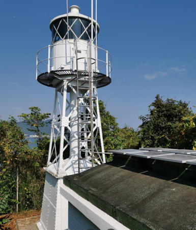
1912. Active; focal plane 37 m (121 ft); white flash every 5 s. 12 m (39 ft) square steel skeletal tower with lantern and gallery. Entire lighthouse painted white. Derek Lo's photo is at right, Wikimedia has a photo and a distant view, Kenneth Pau has a closeup, Cyril Ha has a drone view, Trabas has Wong's distant view, Forand has a historic postcard view, and Google has a satellite view. The station was recognized as a Hong Kong Declared Monument in 2000. Tang Lung Chau is a small island just off the southern end of Ma Wan and off the northeast end of Lantau. Located on the highest point of the island. Accessible only by boat. Site and tower closed. ARLHS HOK-004; HK-062; Admiralty P3530.6; NGA 19520.

Tang Lung Chau (Kap Sing) Light, May 2020
Google Maps photo by Derek Lo
 

Islands District: Kau Yi Chau Lighthouses
Kau Yi Chau
1968. Active; focal plane 9 m (30 ft); two flashes every 6 s, white or red depending on direction. 9 m (30 ft) hexagonal concrete tower supported by a concrete post. Entire lighthouse is white. Trabas has Yuen's photo, a 2023 photo is available, and Google has a satellite view. Located at the northeastern corner of Kau Yi Chau, a small island about 3.5 km (2.2 mi) west of Green Island. Accessible only by boat. Site open, tower closed. HK-081; Admiralty P3537.6; NGA 19504.
Kau Yi Chau South
Around 1981. Active; focal plane 7 m (23 ft); three white flashes every 20 s. 5 m (17 ft) concrete post with gallery rising from a round concrete base. Entire lighthouse is white. Trabas has Yuen's photo and Google has a satellite view. Located on the south side of Kau Yi Chau. Accessible only by boat. Site open, tower closed. HK-085; Admiralty P3537.7; NGA 19508.

Islands District: Pok Liu Chau (Lamma Island) Lighthouses
Lamma Island is a large island parallel to the southwest coast of Hong Kong Island. The Western Entrance to the harbor, also called the Lamma Island Channel, passes between the two islands.

Shek Kok Tsui (West Lamma Island)
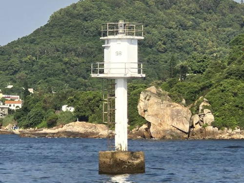
Date unknown. Active; focal plane 12 m (39 ft); three white flashes every 15 s. 12 m (39 ft) concrete post supporting a hexagonal concrete tower. Entire lighthouse is white. Trabas has Yuen's photo (also at right) and Google has an indistinct satellite view. Located off the northwestern tip of Lamma Island. Accessible only by boat but ferries to Lamma Island pass quite close to this light. Site open, tower closed. HK-098; Admiralty P3577.46; NGA 19558.
Pak Kok (Northeast Lamma Island)
Date unknown. Active; focal plane 13 m (43 ft); white flash every 5 s. 5 m (17 ft) concrete post with gallery rising from a round concrete base. Entire lighthouse is white. Trabas has Yuen's photo and Google has an indistinct satellite view. Located on the northeastern tip of Lamma Island. Site open, tower closed. HK-132; Admiralty P3577.44; NGA 19442.
Wong Chuk Kok
Date unknown. Active; focal plane 27.5 m (90 ft); four white flashes every 20 s. 6 m (20 ft) square white concrete tower. Trabas has Wong's photo and Google has a satellite view. NGA calls the light Wong Chu Kok. Located on the eastern tip of Lamma Island across the Western Entrance from Round Island. Site open, tower closed. HK-097; Admiralty P3577.4; NGA 19422.
Yuen Kok
Date unknown. Active; focal plane 35 m (115 ft); white flash every 5 s. 4 m (13 ft) square white concrete building. Trabas has Yuen's closeup photo, Desmond Lau has a 2022 photo, and Google has a satellite view. NGA calls the light Un Kok. Located on the southeastern tip of Lamma Island. Site open, tower closed. HK-096; Admiralty P3577.2; NGA 19412.

Shek Kok Tsui Light, Lamma Island
photo copyright Matthew Yuen; used by permission

Lantau Area Lighthouses
Lantau Island, located southwest of Hong Kong, is the location of the Hong Kong International Airport. It is much less developed than the rest of the SAR; much of it remains forested. The island has a population of about 100,000.
Shek Kwu Chau (Shek Ku Chau)
Date unknown. Active; focal plane 14 m (46 ft); three white flashes every 10 s. 5 m (17 ft) concrete post with gallery rising from a round concrete base. Entire lighthouse is white. Trabas has Wong's photo and Google has an indistinct satellite view. Located on the northern tip of Shek Kwu Chau, an island off the south coast of Lantau. Accessible only by boat. Site open, tower closed. HK-131; Admiralty P3523.4; NGA 19582.
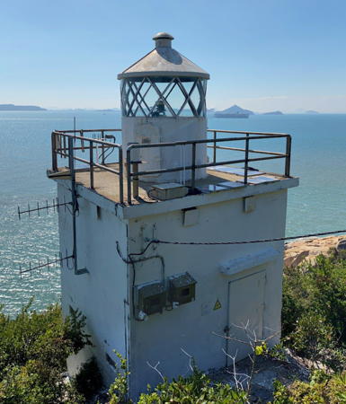
Fan Lau (Wong Fa Pai, Lantau Island) (2)
About 1977 (station established 1936). Active; focal plane 20 m (66 ft); white flash every 5 s. Approx. 9 m (30 ft) square cylindrical masonry tower with lantern and gallery. The tower appears to be unpainted white masonry; lantern painted white. Kai Ming Yu has a 2021 street view seen at right, B. Lam has a good photo, Gabriel Kwok also has a photo, Trabas has Andreas Köhler's 2018 photo, and Google has a satellite view. The lantern was transferred here from the Black Point lighthouse around 1971. The first light was a lantern on a pillar atop an acetylene storage hut. Located at the southwestern tip of Lantau Island. The lighthouse is not far from the ruins of the early 18th century Fan Lau Fort; tours to that area are available. Site open but not so easy to reach, tower closed. HK-056; Admiralty P3524; NGA 19588.

Tuen Mun District Lighthouses
Sha Chau
Date unknown. Active; focal plane 28 m (92 ft); four white flashes every 10 s. Approx. 10 m (33 ft) round white concrete tower. Trabas has Wong's distant view and Google has a satellite view. Located on a small island marking the western entrance to the channel between the mainland and Lantau Island. Accessible only by boat. Site status unknown. Admiralty P3525.5; NGA 19726.
Lung Kwu Chau
1921. Active; focal plane 53.5 m (175 ft); white flash every 5 s. 4 m (13 ft) square cylindrical white concrete tower. L.W. Lau has a photo, Trabas has Wong's distant view, and Google has a somewhat distorded satellite view. Lung Kwu Chau is an island in the Zhujiang estuary about 5 km (3 mi) southwest of Lan Kok Tsui (next entry). The light was relocated to the west in the 1990s in connection with the building of Chek Lap Kok airport. Located on heights at the northwestern end of the island. Accessible only by boat. Site status unknown. HK-058; Admiralty P3526; NGA 19742.
Lan Kok Tsui (Black Point)
Date unknown. Active; focal plane 131 m (430 ft); three white flashes every 10 s. Light mounted on a white metal post next to a skeletal radar tower. Trabas has Wong's distant photo, a 2022 photo is available, and Google has an indistinct satellite view of the location. Located atop a ridge at the westernmost tip of the Hong Kong mainland, near Lung Kwu Tan. Site and tower closed. Admiralty P3526.2; NGA 19746.

Fan Lau Light, Lantau Island, February 2021
Google Maps street view by Kai Ming Yu

Information available on lost lighthouses:

Notable faux lighthouses:

Adjoining pages: East: Shànwěi Area | West: Macau, Pearl River

Return to the Lighthouse Directory index | Ratings key

Posted November 10, 2008. Checked and revised March 12, 2024. Lighthouses: 41. Site copyright 2024 Russ Rowlett and the University of North Carolina at Chapel Hill.