Lighthouses of India: Tamil Nadu and Puducherry

The Republic of India (Bhārat in Hindi) is the seventh largest country and second most populous country in the world. It occupies a subcontinent of Asia that projects southward into the North Indian Ocean, separating the Bay of Bengal on the east from the Arabian Sea on the west. Before 1947 it was a patchwork of regions governed as British colonies and semi-independent princely states under British supervision. In 1947 this British Raj was partitioned into the independent states of India and Pakistan. Several French and Portuguese colonies embedded in the territory of India were absorbed in 1950 and 1961, respectively.

India is a federal union comprising 28 states and 8 union territories. This page lists lighthouses of Tamil Nadu, the state on the east side of the southern tip of the Indian subcontinent. Embedded in Tamil Nadu are the Puducherry and Karaikal districts of the Union Territory of Puducherry (formerly called Pondicherry), the former French India.

The Tamil Nadu coastline, facing the Bay of Bengal, is almost everywhere low and sandy with numerous offshore shoals. Chennai (Madras) is the state capital and largest port but there are many smaller ports. The disastrous tsunami of 26 December 2004 caused great destruction and loss of life on this coast but no lighthouses were destroyed.

India's lighthouse heritage is British. However, only a fraction of the original British lighthouses remain in use; new towers have been built at most of the stations. India has also built many lighthouses at new locations in recent years. Nearly all of the larger Indian lighthouses are staffed and by long tradition the staff will receive visitors at a specific time, usually late in the afternoon. Several lighthouses have been developed as tourist attractions and have longer hours.

Hindi and English are official languages in India, with English serving as a lingua franca for the entire nation. The Indian Constitution recognizes another 21 languages, called scheduled languages, and each of the coastal states has its own scheduled language in official use. In Tamil, the official language of Tamil Nadu, the word for a lighthouse is kalaṅkarai (கலங்கரை); tīvu is an island, nati is a river, and tuṟaimukam is a harbor.

Lighthouses and aids to navigation in India are administered by the Directorate General of Lighthouses and Lightships (DGLL), an agency of the Ministry of Shipping. The lighthouses on this page are maintained by the Chennai Directorate of DGLL.

The Tamil word for a lighthouse is kalaṅkarai (கலங்கரை); tīvu is an island, nati is a river, and tuṟaimukam is a harbor.

ARLHS numbers are from the ARLHS World List of Lights. Admiralty numbers are from volume F of the Admiralty List of Lights & Fog Signals. U.S. NGA List numbers are from Publication 112.

General Sources
Aids to Navigation - Chennai Region
Lighthouse information from DGLL, including photos of the lighthouses.
Lighthouses in India
Photos available from Wikimedia.
World of Lighthouses - India
Photos by various photographers available from Lightphotos.net.
Online List of Lights - India
Photos by various photographers posted by Alexander Trabas.
Indian Lighthouses
Historic postcard images posted by Michel Forand.
Leuchttürme Asiens auf historischen Postkarten
Historic postcard images posted by Klaus Huelse.
Navionics Charts
Navigation chart for the Tamil Nadu coast.


Mahabalipuram Light, Mahabalipuram, February 2015
Wikimedia Creative Commons photo
by Alanvel

East Coast (Bay of Bengal) Lighthouses

Tiruvallur District Lighthouse
** Pulicat (Pazhaverkadu) (2)
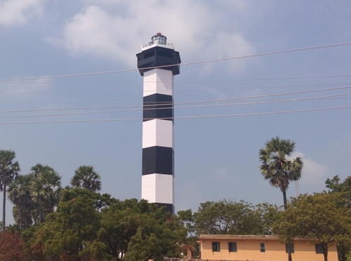
1986 (station established 1862). Active; focal plane 53 m (174 ft); white flash every 5 s. 49 m (160 ft) hexagonal cylindrical concrete tower with lantern and gallery, painted with horizontal black and white bands. A photo is at right, Manas Karkal has a 2023 photo, Vasant Viswanathan has a good photo, Jeevan Kumar has a photo, John Peter has a street view, and Google has a satellite view. In January 2014 the lighthouse was opened to visitors for the first time. Pulicat Lake is a large lagoon on the border between Andhra Pradesh and Tamil Nadu. Pulicat (Pazhaverkadu), on the south side of the lagoon entrance, was settled by the Portuguese in 1502. Captured by the Dutch in 1609, it served as a Dutch base in India for many years; the British occupied it in 1825. The original lighthouse was a "column" 18 m (60 ft) in height. Located at Lighthouse Village on Pulicat Island, the barrier island, on the south side of the lagoon entrance; the island is accessible by bidge from the mainland. Site open, tower open but the schedule is not known. . ARLHS IND-055; Admiralty F0950; NGA 27068.
Ennore (Kamarajar) Range Front (2?)
Date unknown. Active; focal plane 19 m (62 ft); white light occulting once every 5 s. Approx. 16 m (52 ft) square skeletal tower. No photo available but Google has a satellite view. This range guides vessels into a new port about 25 km (15 mi) north of Chennai. The satellite views show two towers for each of these range lights, so it appears the lights were moved to taller towers. Located on the waterfront of the port. Site and tower closed. Operator: Kamarajar Port Ltd. Admiralty F0946.
Ennore (Kamarajar) Range Rear (2?)
Date unknown. Active; focal plane 29 m (95 ft); white light occulting once every 5 s. Approx. 26 m (85 ft) square skeletal tower. No photo available but Google has a satellite view. Located about 800 m (1/2 mi) north northwest of the front light. Site and tower closed. Operator: Kamarajar Port Ltd. Admiralty F0946.1.

Pulicat Light, Pulicat, February 2018
Google Maps photo
by Tamil new movies&songs

Chennai District Lighthouses
Chennai, the capital of Tamil Nadu, was known historically as Madras; the name was changed officially in 1996. Chennai is India's sixth largest city with a population of more than 7 million.

Chennai Fishing Harbour North Breakwater
Date unknown. Active; focal plane about 8 m (26 ft); continuous green light. 5 m (17 ft) square equipment shelter with a light on a short post. Building painted with narrow green and white vertical stripes. Thanunjeyan Yohenthiran has a 2022 photo, Musthafa Ibrahim has a view along the pier, John Peter has a distant street view, and Google has a satellite view. Located on the north breakwater of the harbor, a short distance north of the main Chennai harbor. Site status unknown. Admiralty F0945.7.
Chennai Fishing Harbour East Breakwater ("Chennai View Point")
Date unknown. Active; focal plane about 8 m (26 ft); continuous red light. 5 m (17 ft) square equipment shelter with a light on a short post. Building painted with narrow red and white vertical stripes. Mohd Ashraf has a 2022 photo, a 2021 photo is available, John Peter has a distant street view, and Google has a satellite view. Located on the east (main) breakwater of the harbor, a short distance north of the main Chennai harbor. Site status unknown. Admiralty F0945.8.
Chennai Entrance Channel
Date unknown. Inactive since 2008. Approx. 24 m (79 ft) control tower. No photo available but Google has a satellite view. Located between the Fishing Harbour and the main harbor facilities in Chennai. Site status unknown. ex-Admiralty F0938; ex-NGA 27074.
Chennai Harbour Outer Arm
Date unknown. Active; focal plane 13 m (43 ft); two red flashes every 6 s. Approx. 10 m (30 ft) square cylindrical tower. No photo available but Google has a satellite view. Located at the end of the main breakwater of Chennai harbor. Site status unknown. Admiralty F0942; NGA 27080.
Chennai Harbour Outer Arm Spur
Date unknown. Active; focal plane 10 m (33 ft); red flash every 5 s. 5 m (17 ft) concrete post attached to a round 1-story concrete equipment shelter. A 2022 view is available and Google has a satellite view. Located on an inner spur of the main breakwater. Site status unknown. Admiralty F0940; NGA 27076.
* Madras (2)
1844 (station established 1796). Inactive since 1894. 49 m (160 ft) round fluted stone tower with lantern and gallery. Lantern dome painted red. A 2018 photo is at right, Selvakumar Chandrasekaran has a 2022 photo, Balu Velachery has a 2005 photo, Huelse has a historic postcard view of this tower and the High Court building (next entry), Forand has a historic postcard view showing the tower with its lantern, and Google has a satellite view. The first light at Madras was a lantern on the Exchange Building (now the Fort Museum) in the British Fort George. The light was moved to this tower behind the fort, and then to the neighboring High Court after that building was constructed in 1892. Repairs were ordered in 2012 when the tower was reported to be in poor condition. Restoration work began in late 2015 and included installation of a replica lantern. The restored lighthouse was rededicated in September 2017. There were plans to open the restored tower for climbing, but it's not clear if that has occurred. Located in downtown Madras, now called Chennai. Site open, tower closed. ARLHS IND-027.


1844 Madras Light, Chennai, December 2018
ex-Google Plus photo by Chandra U

* Madras (3)
1894 (station established 1796). Inactive since 1977. The light was mounted in the cupola of the tallest of the ornate towers of the High Court building, which was constructed adjacent to the old lighthouse in 1892. Krishna Prasad Iyer has a photo, Balu Velachery has a 2005 photo, Huelse has a historic postcard view of the court and old lighthouse, and Google has a satellite view. Located in downtown Madras, now called Chennai. Site open. ARLHS IND-026.
**** Chennai (Madras (4))
1977 (station established 1796). Active; focal plane 57 m (187 ft); two white flashes every 10 s. 46 m (151 ft) pentagonal cylindrical concrete tower with lantern and double gallery, attached to a 3-story circular harbor control building. The two seaward sides of the lighthouse are painted with horizontal red and white bands. A photo is at right, Trabas has Eckhard Meyer's photo, Kelly Cheng also has a photo, R. Srijith has a view from the beach, Wikimedia has several photos, Balasubramanian Venkatadri has a street view, and Google has a satellite view. Waves from the great tsunami of 26 December 2004 damaged the base of the lighthouse, but there were no casualties. The lighthouse reopened to tourists in November 2013 after being closed for 22 years; visitors can take an elevator to the lower gallery on the 9th floor. Located at the modern harbor of Chennai (Madras), on the north side of the central city. Site open, tower open daily except Mondays (a small fee is charged). . ARLHS IND-010; Admiralty F0936; NGA 27072.

Kanchipuram District Lighthouses
*** Mahabalipuram (Mamallapuram) (1) (temple)
1887. Inactive since 1900. Approx. 20 m (66 ft) square stone structure with gallery atop a monolithic stone temple (carved from a single rock), dating from around the start of the 8th century AD. Wikimedia has a closeup, a distant photo is available, and Forand has a historic postcard view. Fires were lit atop this temple for centuries as a guide to seamen, and in 1887 the British placed a lantern atop the temple for the same purpose. The lantern was removed long ago. Site and temple open daily; visitors can climb to the gallery level.
**** Mahabalipuram (Mamallapuram) (2) (lighthouse)
1900 (station established 1887). Active; focal plane 42 m (138 ft); white flash every 10 s. 26 m (85 ft) round stone tower with lantern and gallery; unpainted; lantern dome painted red. 2nd order Fresnel lens in use. A 2015 photo is at the top of this page, Srini Swaminathan has a closeup photo, Trabas has a photo by Alfonso Biescas Vignau, Wikimedia has numerous photos, Asharul Seikh has a 2021 photo, Forand has a historic postcard view, Huelse has a closeup postcard view, and Google has a street view and a satellite view. This is probably the best known and most often visited lighthouse on India's east coast. In 2013 it was one of the first lighthouses in India identified for tourist development. In January 2014 a lighthouse museum was added to the station. Built atop a large rock at Mahabalipuram, about 65 km (40 mi) south of Chennai. Site open, museum open daily, tower open daily 2-4 pm. . ARLHS IND-016; Admiralty F0932; NGA 27108.
New Chennai Light
1977 Chennai Light, Chennai, December 2012
Flickr Creative Commons photo by okramesh

Viluppuram District Lighthouse
* Kadapakkam (Alam Parai Fort, Marakkanam)
2013. Active; focal plane 36 m (118 ft); three white flashes every 20 s. 32 m (105 ft) round cylindrical concrete tower with lantern, gallery, and a round observation platform. Lighthouse painted with red and white spiral bands. Prem Kumar has a 2016 photo, V. Saravanan has a distant view, Sandeep Jinnu has a closeup 2019 photo, and Google has a street view and a satellite view. The lighthouse was placed in service in November 2013. Located in Kadapakkam, a town about 40 km (25 mi) north of Puducherry, close to the historic (1760) Alamparai Fort. Site open, tower status unknown. Admiralty F0929; NGA 27110.

Puducherry: Puducherry (Pondicherry) District Lighthouses
Founded in 1673 by the French East India Company, Puducherry (formerly Pondicherry in English or Pondichéry in French) was the chief French colonial settlement in India. After nearly three centuries of French rule it was united with the Republic of India in 1954 and has been governed as a union territory since 1956. The union territory also includes the enclaves of Karaikal in Tamil Nadu (see below for the Karaikal lighthouse), Yaman in Andhra Pradesh, and Mahé in Kerala (see the Kerala page for the Mahé lighthouse).

*
Puducherry (Pondicherry) (1)
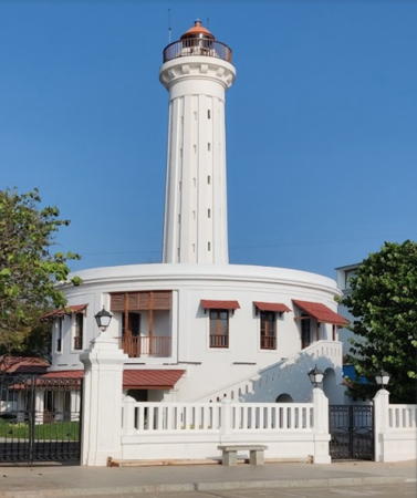
1836. Inactive since 1979. 27 m (89 ft) round fluted stone tower with lantern and gallery, rising from the center of a circular 1-story keeper's house. Lighthouse is white; lantern dome painted red. Jigar Thacker's 2023 photo is at right, Wikimedia has a closeup photo by Mohan Krishnan, Debasish Pramanik has a 2018 photo, Shantanu Kumar has a 2016 street view, Huelse has a historic postcard view, Forand has a closeup postcard view and a distant postcard view, Vassil Mladjov has a street view, and Google has a satellite view. This elegant lighthouse had several uses after deactivation; in recent years it was a toy museum. The territorial government tried to assume ownership to restore the lighthouse as a museum of the city's French architectural heritage. The Customs and Central Excise Department refused to give up ownership but promised to repair and refurbish the building. A November 2017 photo shows the lighthouse apparently repaired, and there's an April 2018 street view from atop the lighthouse. In early 2020 a plan was approved for a more complete $500,000 restoration leading to opening the lighthouse as a tourist attraction. Work on the project began in November 2020 but was slowed by the pandemic; an October 2022 photo shows the completed work. Located on the sea front in Puducherry. Site open, tower has been closed for restoration; we need information on whether it is now open. . ARLHS IND-052.
*** Puducherry (Pondicherry) (2)
1979 (station established 1836). Active; focal plane 48 m (157 ft); two white flashes every 15 s. 46 m (151 ft) hexagonal cylindrical concrete tower with an expanded watch room, lantern and gallery, plus two additional galleries lower on the tower. Lighthouse painted with horizontal black and white bands. Krishna Kumar has a closeup 2016 photo, Sea-Seek.com has a photo, Karthik Easvur has a 2015 photo, Sandhikshan Das has a 2022 photo, Siva Kumar Sathyamangalam has a view from the sea, Kamal Bharathi has a street view from atop the lighthouse, Arun Vasanth has a street view, and Google has a satellite view. The lighthouse opened to tourists in 2014. Located in south Puducherry, about 2 km (1.25 mi) south of the historic lighthouse. Site open, tower open 2 to 5 pm daily. . ARLHS IND-012; Admiralty F0926; NGA 27112.

1836 Pondicherry Light, Puducherry, March 2023
Google Maps photo by Jigar Thacker


Cuddalore District Lighthouses
* Cuddalore (3)
1991 (station established 1889). Active; focal plane 18 m (59 ft); white flash every 5 s. 18 m (59 ft) round concrete tower with lantern and gallery, painted white. Vel Murugan has a good 2019 photo, Kalai Ashwin has a 2018 photo, Sea-Seek.com has a photo, and Google has a satellite view. The original light was on a flagstaff; it was replaced in 1902 by a round tower seen in Forand's historic postcard view. The tsunami of 26 December 2004, did serious damage in and around Cuddalore. More than 500 people were killed. The port area was devastated, but the lighthouse survived. The lighthouse was trnsferred from the Tamil Nadu government to DGLL in 2014. Located just inside the port entrance in Cuddalore. Site open, tower status unknown. ARLHS IND-029; Admiralty F0920; NGA 27120.
* Porto Novo (Parangipettai)
1981. Active; focal plane 36 m (118 ft); white flash every 15 s. 39 m (128 ft) round cylindrical concrete tower with lantern and double gallery, painted with horizontal red and white bands. Vinoth Kumar has a 2022 photo, P.C.R. Antony has a closeup photo, Hasan Shaik has a photo, and Google has a satellite view. This was another location hit badly by the tsunami of 26 December 2004. One of the keepers lost his father and his son to the tsunami. The three daughters of the head keeper were also washed away, but they were rescued by local villagers. Named by Portuguese sailors, Porto Novo (Parangipettai) is a historic European base (its Tamil name means "home of the foreigners"). However, it is only a minor fishing village today. Located about 8 km (5 mi) northeast of Bhuvanagiri. Site open, tower status unknown. ARLHS IND-053; Admiralty F0919; NGA 27132.

Northern Nagapattinam District Lighthouse
* Poompuhar (Pumpoohar, Puhar)
2010. Active; focal plane unknown; four white flashes every 15 s. 30 m (98 ft) octagonal cylindrical concrete tower with lantern, gallery, and an octagonal observation level below the lantern. Lighthouse painted with red and white vertical stripes. A photo is at right, Peer Mohamed has a 2016 closeup photo, Pagu Pandian has a 2011 photo, a 2022 photo and a street view from the gallery are available, and Google has a satellite view. The light is listed as "Pumpukar" by NGA. Located near Kaveripatnam, about 30 km (19 mi) north of Karaikal. Site open; the tower is to be open to the public, according to one news source. Admiralty F0918: NGA 27134.

Poompuhar Light, Kaveripatnam, December 2015
Wikimedia Creative Commons photo by Destination8infinity

Puducherry: Karaikal District Lighthouses
Karaikal was a French colony from 1739 to 1954. Now part of the Puducherry union territory, it has a population of about 200,000.
* Karaikal (Karikal, Caricall) (3)
1901 (French) (station established 1853). Active; focal plane 18 m (59 ft); two white flashes every 10 s. 18 m (56 ft) round cylindrical white concrete tower with lantern and gallery. Sahib Nagore has a 2021 photo, Ameer Muhsin has a closeup 2019 photo, and Google has a satellite view. The current lantern was installed recently; Jaikumar Natarajan has a 2011 photo and Binoop Vasudevan has a 2014 photo showing that the original lantern was removed. The first lights were displayed here from a flagstaff; a masonry "column" was built in 1864. More than 500 fishermen from the area were killed by the tsunami of 26 December 2004. Located just off the beach at Karaikal. Site open, tower status unknown. . ARLHS IND-037; Admiralty F0916; NGA 27136.
Karaikal Range Front
Date unknown. Active; focal plane 19 m (62 ft); white flash every 5 s synchronized with the rear light. Approx. 16 m (52 ft) square skeletal tower. The tower is at the left in Alok Kumar's July 2017 photo of the waterfront and Google has a satellite view. Located at a new port about 12 km (7.5 mi) south of the traditional port. Site and tower closed. Admiralty F0914.5.
[Karaikal Range Rear]
Date unknown. Active; focal plane 24 m (79 ft); white flash every 5 s synchronized with the front light. Approx. 20 m (66 ft) steel post. No photo available but Google has an indistinct satellite view. Located 490 m (0.3 mi) due west of the front light. Site and tower closed. Admiralty F0914.51.

Southeastern Nagapattinam District Lighthouse
* Nagappattinam (Negapatam) (3)
1923 (station established 1846). Active; focal plane 48 m (157 ft); two white flashes every 20 s. 50 m (164 ft) round masonry tower with lantern and gallery, painted with horizontal black and white bands; lantern roof painted red. A district government photo is at right, Satheesh Rajendren has a 2018 photo, Denis Elton has a 2017 closeup, Krishna Kumar Goutam has a 2022 closeup, Rajarshi Banerjee has a nighttime photo of the lighthouse in action, and Google has a good satellite view. This is India's southernmost port on the Bay of Bengal. The British built a 20 m (66 ft) lighthouse here in 1846, and the present lighthouse replaced a 23 m (75 ft) tower built in 1870. Nagappatinam District had the heaviest loss of life during the tsunami of any place on the Indian coast: more than 6000 villagers and fishermen were killed. The lighthouse and its staff survived. Located just off the beach in Nagappattinam. Site open, tower status unknown. ARLHS IND-045; Admiralty F0914; NGA 27140.
Nagapattinam Light
Nagapattinam Light, Nagapattinam
Nagapattinam District government photo

South Coast Lighthouses

The strait separating India and Sri Lanka, known in Tamil as Sethusamudram ("sea bridge"), is crossed by a chain of reefs and islands called Adam's Bridge (also called Rama's Bridge, or Rama Setu in Tamil). North of Adam's Bridge the strait is a shallow embayment called Palk Bay or Palk Strait. South of Adam's Bridge is a much deeper embayment called Mannar Bay or the Gulf of Mannar. In its natural condition Palk Bay is too shallow for modern ships, and the Adam's Bridge line of shoals is impassable for all but the smallest vessels. Since 2004 the government of India has studied the possibility of dredging a deepwater channel some 83 km (45 mi) long to open the strait to the largest ships. The Sethusamudram Shipping Canal Project has met considerable resistance from scientists and environmental groups. Considerable work has been done but as of 2020 work is stopped and it is not clear that it will be completed. However, in preparation for possible shipping increases several large new lighthouses were built along the strait.

Southern Nagapattinam District Lighthouse
* Calimere Point (Kallimedu)
1890. Active; focal plane 13 m (43 ft); three white flashes every 10 s. 16 m (52 ft) round cylindrical tower with lantern and gallery. Lighthouse painted white; lantern dome is red. A 2018 photo is at right, P.J. Sinna has a 2011 photo, Chandru Sekar has a 2021 photo, and Google has a satellite view. This historic lighthouse and the Kodikkaraik the northern entrance to Palk Bay. Located on Calimere Point, about 60 km (37.5 mi) south of Nagappattinam. Site open, tower status unknown. ARLHS IND-024; Admiralty F0910; NGA 27144.
* [Chola Lighthouse]
10th century CE. Brick ruins on the beach at Calimere Point are remnants of a lighthouse built during the reign of Paranthaka Chola (907-955 CE), one of the early rulers of the Chola dynasty that ruled south India from the mid ninth to early thirteenth centuries. Wikimedia has a photo, Jeevan Kumar has a photo, and Dhinesh Ramalingam has a street view. Endangered: Oli Mohd's June 2004 photo shows a much taller ruin but the tsunami of December 2004 destroyed much of that tower and continuing erosion has brought the surf close to the site. In 2017 officials ordered a seawall built to protect what remains but a February 2018 photo shows only inadequate efforts. The ruins are close to an observation tower built at the end of Lighthouse Road south of the modern Calimere Point lighthouse; Google's satellite view shows the observation tower. Site open.
 

Calimere Point Light, Nagapattinam, June 2018
Google Maps photo by Ramamurthi
* Kodikkarai
1997. Active; focal plane 45 m (148 ft); white flash every 10 s. 45 m (148 ft) round masonry tower with lantern and double gallery, painted with horizontal red and white bands. The lantern was used previously at Pulicat Light. A photo is at right, Marcus Sherman has a 2008 photo, Mohanram Kemparaju has another photo, Vignesh Waran has a photo and a street view from atop the lighthouse, and Google has a satellite view. Kodikkarai is an alternate Tamil name of Calimere Point. Located about 9 km (5.5 mi) west southwest of Calimere Point Light. Site status unknown, probably open. ARLHS IND-039; Admiralty F0902; NGA 27145.

Thanjavur District Lighthouse
* Mallipattinam (Mallipatnam, Malipatinam)
2010. Active; focal plane unknown; four white flashes every 15 s. 45 m (148 ft) octagonal cylindrical concrete tower with lantern, gallery, and an octagonal observation level below the lantern. Lighthouse painted with red and white vertical stripes (the first Indian lighthouse to have this daymark). Prem Kumar has a 2018 photo, Marimuthu Rajaguru has a 2022 photo, Mohammed Tharik has a distant street view, and Google has a satellite view. Located on Palk Strait at Manora, about 50 km (30 mi) west of Calimere Point. Site open, tower closed. Admiralty F0901.9; NGA 27148.

Pudukkottai District Lighthouses
* Ammapattinam (Manamelkudi) (2?)
2005. focal plane 49 m (161 ft); two white flashes every 15 s. 45 m (148 ft) round cylindrical concrete tower with lantern and double gallery, painted with horizontal black and white bands. S. Sridhar has a 2019 photo, a 2016 photo is available, Raja Mohamed has a 2017 closeup, and Google has a street view and a satellite view. This lighthouse and similar lights at Pasipattanam and Rameshwaram were built by the slipform method to improve navigation in the Palk Strait. The immediate purpose was to help Indian fishermen stay in Indian territorial waters without straying over into Sri Lankan waters; ultimately they may guide ships through the Sethusamudram Ship Channel. An inauguration ceremony for the three lighthouses was held here on 9 October 2005. A 1909 light list records that a light was shown from the port flagstaff. Located on a point of land south of Manamelkudi, on the west side of Palk Strait about 65 km (40 mi) southwest of Calimere Point. Site open, tower closed. ARLHS IND-020; Admiralty F0901.7; NGA 27150.

Kodikkarai Light, Kodikkarai, March 2022
Google Maps photo by Mr JW

Ramanathapuram District (Adam's Bridge Area) Lighthouses
* Pasipattinam
2005. Active; focal plane 49 m (161 ft); three white flashes every 10 s. 45 m (148 ft) round cylindrical concrete tower with lantern and double gallery, painted with horizontal red and white bands. Eshwar Viswam has a 2023 photo, Thiru Vasagam has a 2021 photo, SS. Sakthivel has a 2020 photo, and Google has a satellite view. Located at Pasipattanam on the west side of Palk Strait, about 10 km (6 mi) north of Thondi. Site open, tower closed. ARLHS IND-050; Admiralty F0901.5; NGA 27151.
* Pamban (Pamban Pass) (2)
1902 (station established 1845). Active; focal plane 29 m (95 ft); three white flashes every 9 s. 20 m (66 ft) round masonry tower, painted with horizontal black and white bands. A photo is at right, Selvamanee Rajendran has a closeup, another photo and a distant photo are available, Srinivasan KB has a 2021 photo, K.S. Chandra has a photo taken from the Pamban Channel Bridge, and Google has a satellite view of the station. The original lighthouse, listed as "Palk Bay" on Findlay's 1879 list, was a round 17 m (56 ft) stone tower. Pamban Island is on the Indian section of the limestone ridge known as Rama's Bridge or Adam's Bridge. The "bridge" was dry land as recently as 6000 years ago, but the rising sea has broken it into a chain of islands. Pamban Channel separates the island from the Indian mainland. The lighthouse is located on the north side of Pamban Island east of the Pamban Channel Bridges. Site status unknown, probably open. . ARLHS IND-048; Admiralty F0900; NGA 27168.
Rameshwaram (Rameswaram, Olakuda)
2005. Active; focal plane 16.5 m (54 ft); two white flashes every 20 s. 15 m (49 ft) square masonry tower with gallery, painted with red and white spiral bands. Venkatasubramaniam Arumugam has a 2017 photo, Ankita Shelke has a 2018 closeup, Joseph Augustine has a 2019 photo, and Google has a satellite view. Like the lights at Manamelkudi and Passipatnam, this lighthouse was built as part of the Palk Strait Lighthouse Project. In 2013, this was one of the 15 lighthouses identified for tourist development by DGLL. Rameswaram, the principal town of Pamban Island, is an important destination for Hindu pilgrims. A change in the Admiralty number for this lighthouse was announced in an Indian Notice to Mariners in February 2015. Located on the northeasternmost point of Pamban Island. Site status unknown. ARLHS IND-058; Admiralty F0906; NGA 27167.

Pamban Channel Light, Rameshwaram, September 2014
Wikimedia Creative Commons photo by Drajay1976
* Dhanushkodi
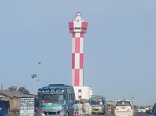
2022. Active; focal plane about 52 m (171 ft); white light, pattern unknown. 49 m (161 ft) octagonal concrete tower centered on a 2-story building and carrying a large octagonal observation room. Tower and observation room painted in a red and white checkerboard pattern. Thiru Prabhu has the June 2022 photo seen at right, Omprasad Damkondwar has a May 2022 photo, and Google has a satellite view. The lighthouse was inaugurated in May 2022. Its navigational purpose is unclear but it marks an extremity of Indian terrirory. Located near the end of the Indian portion of Adam's Bridge, a well known tourist attraction. Site status open, tower closed. Not yet listed by the Admiralty.
* Kilakarai (Kilakkarai)
1979. Active; focal plane 35 m (115 ft); white flash every 15 s. 30 m (98 ft) hexagonal concrete tower with lantern and double gallery, painted with horizontal red and white bands. Nithish Shajan has a 2022 photo, Waleed Maraika has a 2016 photo, Mohamed Anas has view from the bay, Hanees Karattu has a street view, and Google has a satellite view. Located at Kilakarai, on the northern shore of the Gulf of Mannar about 16 km (10 mi) south of Ramanathapuram. Site open, tower closed. ARLHS IND-038; Admiralty F0738; NGA 27172.
[Valinokkam]
Date unknown. Approx. 8 m (26 ft) square cylindrical brick tower falling into ruin. Abdul Rahman has a photo and a closeup and Google has a satellite view. This tower is identified by Google Maps an "Old Lighthouse," but nothing is known of its history. It certainly functions informally as a daybeacon. Located on a sand spit projecting into the Gulf of Mannar at Valinokkam. Site open, tower closed.

Dhanushkodi Light, Rameshwaram, June 2022
Google Maps photo by Thiru Prabhu

Thoothukudi (Tuticorin) District (Gulf of Mannar) Lighthouses
Thoothukudi (known as Tuticorin until 2018) is a major seaport and pearl fishing center; it has a population of more than 400,000.
* Vembar (Vember)
2016. Active; focal plane 30 m (98 ft); three white flashes every 10 s. 30 m (98 ft) octagonal concrete tower with lantern and gallery, painted with black and white horizontal bands. Cyril Xavier has a photo, a 2017 photo is available, Siva Sankar has a 2020 photo, Dhananjay Singh has a distant street view, and Google has a satellite view. Located just off the beach at Vembar, a fishing village at the northern border of the Thoothukudi District. Site open, tower closed. Admiralty F0737.
* Tutucorin North Range Front
Date unknown. Active; focal plane 9 m (30 ft); quick-flashing white light. 8 m (26 ft) square pyramidal skeletal tower. A photo is available and Google has a satellite view. Located at the end of a pier in Tuticorin's VOC Port, north of the main lighthouses. Probably accessible by walking the pier. Site probably open, tower closed. Admiralty F0736; NGA 27180.
* Tutucorin North Range Rear
Date unknown. Active; focal plane 13.5 m (44 ft); quick-flashing white light. Approx. 10 m (33 ft) square pyramidal skeletal tower atop a 2- or 3-story building. Jose Princely has a photo but the tower is not seen in Google's satellite view. Located on Beach Road near the Customs House, 259 m (850 ft) west of the front light. Site probably open, tower closed. Admiralty F0736.1; NGA 27184.
* Pandiyan Tivu (Thoothukudi, Tuticorin) (3)
1935 (station established 1845). Inactive since 1979. Approx. 22 m (72 ft) round cylindrical concrete tower painted with horizontal black and white bands. Lantern removed. Satheeshkannan Satheeshkannan has a 2017 photo, Prakash Nainar also has a photo, Forand has a historic postcard view, and Google has a good satellite view. The lighthouse is probably endangered by its abandonment. Located about 150 m (500 ft) north of the modern lighthouse. Site open, tower closed. ARLHS IND-063.
* Pandiyan Tivu (Thoothukudi, Tuticorin) (4)
1979 (station established 1845). Active; focal plane 48 m (157 ft); white flash every 10 s. Approx. 40 m (131 ft) round cylindrical tower with lantern and double gallery, painted with black and white spiral bands. Muruga Perumal has a photo (also seen at right), Satheeshkannan Satheeshkannan has a 2017 photo, and Google has a good satellite view. The first light at this station was shown from a flag post; this was replaced by an 11 m (36 ft) masonry obelisk and then by the 1935 lighthouse. Located on an island (tivu) protecting the harbor of Thoothukudi (Tuticorin). The island is connected to the mainland by a causeway and the lighthouse is accessible by road. Site open, tower closed. ARLHS IND-062; Admiralty F0734; NGA 27176.

Pandiyan Tivu Light, Thoothukudi, September 2017
Google Maps photo
by Muruga Perumal
Tuticorin Harbour Range Front
Date unknown. Active; focal plane 20 m (66 ft); quick-flashing white light. Approx. 16 m (52 ft) skeletal tower painted with red and white horizontal bands. No photo available but Google has a satellite view. Located on the north pier of Tuticorin Harbour. Site and tower closed. Admiralty F0735; NGA 27192.
Tuticorin Harbour Range Middle
Date unknown. Active; focal plane about 25 m (82 ft); light characteristic unknown. Approx. 21 m (69 ft) skeletal tower painted with red and white horizontal bands. No photo available but Google has a satellite view. Located on a platform off the north pier of Tuticorin Harbour. Accessible only by boat. Site and tower closed. Admiralty F0735.05.
Tuticorin Harbour Range Rear
Date unknown. Active; focal plane 59 m (194 ft); white light occulting once every 10 s. Approx. 55 m (180 ft) square pyramidal skeletal tower painted with black and white horizontal bands. No photo available but Google has a satellite view. Located on a short pier 2.36 km (1.47 mi) northwest of the front light. Site and tower closed. Admiralty F0735.1; NGA 27196.
Tuticorin Harbour North Breakwater
Date unknown. Active; focal plane 9 m (30 ft); white light, 2 s on, 3 s off. 7 m (23 ft) square skeletal tower painted with black and white horizontal bands and mounted on a square 1-story white concrete base. Dinesh Gupta has a photo (light at the end of the far pier) and Google has a satellite view. Located at the end of the north pier of Tuticorin Harbour. Site and tower closed. Admiralty F0735.5; NGA 27188.
Tuticorin Harbour North Breakwater Spur
Date unknown. Active; focal plane about 10 m (33 ft); quick-flashing green light. Approx. 8 m (26 ft) square skeletal tower painted with black and white horizontal bands and mounted on a square 1-story white concrete base. Dinesh Gupta has a photo (light on the far pier, left of center) and Google has an indistinct satellite view. Located on the north side of the entrance to Tuticorin Harbour. Site and tower closed. Admiralty F0735.6; NGA 27189.
Tuticorin Harbour East Breakwater
Date unknown. Active; focal plane unknown; quick-flashing red light. This light is mounted somewhere, probably low, on a square skeletal radar tower at least 40 m (131 ft) tall. Dinesh Gupta has a photo and Google has a satellite view. Located on the south side of the entrance to Tuticorin Harbour. Site and tower closed. Admiralty F0735.7; NGA 27189.1.
* Manapad (Manappad) Point
1888. Active; focal plane 45 m (148 ft); two white flashes every 10 s. Approx. 18 m (59 ft) round masonry tower painted with red and white spiral bands; lantern dome painted red. Keeper's house and several other light station buildings. Leo Fernando's photo is at right, a sunset photo is available, and Google has a satellite view of the station. This well-known lighthouse adjacent to a Catholic church founded in 1581 by Portuguese missionaries. Located on Manapad Point, a prominent cape about 20 km (12.5 mi) south of Tiruchchendur. Site open, tower status unknown. . ARLHS IND-044; Admiralty F0730; NGA 27200.
Manapad Point Light
Manapad Point Light, Manapad, May 2008
ex-Panoramio photo copyright Leo Fernando; used by permission

Tirunelveli District Lighthouse
* Kuthenkuli (Kooththenkuzhi)
2020. Active; focal plane 45 m (148 ft); three white flashes every 20 s. 45 m (148 ft) round cylindrical concrete tower with lantern and gallery painted in a red and yellow checkerboard pattern. A closeup photo is available and Google has a satellite view. Located at Kuthenkuli halfway between Manapad and Kanyakumari. Site open, tower closed. Admirakty F0728.

Kanyakumari District (Cape Comorin Area) Lighthouses
** Kanyakumari (Cape Comorin)
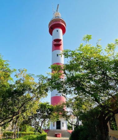
1971. Active; focal plane 63 m (207 ft); two white flashes every 20 s. 30 m (98 ft) square masonry tower with gallery and a small lantern, painted with red and white horizontal bands. A photo is at right, Vincent Kiran has a 2021 closeup, Krishna Kumar also has a closeup, V.C. Charuvalath has a good 2016 photo, Chandrachoodan Gopalakrishnan has a view from the sea, and Google has a satellite view and a closeup street view. In 2013 this was one of the 15 lighthouses identified for tourist development by DGLL. Kanyakumari (also spelled Kanniyakumari) is the southernmost tip of India at 8°05' N latitude. The British renamed it Cape Comorin, a name found on most foreign maps but rarely used in India. It is a very popular tourist destination, and many tourist web sites say "one can get a panoramic view" from the lighthouse. Located on the heights above the point of the cape. Site open, tower open 3 to 6 pm daily. . ARLHS IND-080; Admiralty F0726; NGA 27484.
**** Muttom Point (Muttam Point, Kadiapatam) (2)
1883 (station established 1875). Active; focal plane 43 m (141 ft); white flash every 5 s. 22 m (72 ft) round masonry tower with lantern and gallery, painted with black and white horizontal bands; lantern dome painted red. A rotating 2nd order Fresnel lens is in use. Mohanraj Kolathapilly has a good closeup, Wikimedia has a 2007 photo, Raja Gopal Sunkara has a 2018 photo, Chris Jehin has an aerial view, and Google has a satellite view. A surviving British lighthouse, Muttom Light can be seen from a popular beach. Early mast and post lights here were followed by a 22 m (72 ft) granite tower in 1875. In 2013, this was also one of the 15 lighthouses identified for tourist development by DGLL. A museum has opened as part of the station; a 3rd order Fresnel lens is on display. The lighthouse was a nominee for IALA Lighthouse of the Year in 2020. Located on a small rocky promontory 32 km (20 mi) west northwest of Kanyakumari and about 18 km (11 mi) southwest of the city of Nagarcoil. Accessible by road. Site open, museum and tower open daily. . ARLHS IND-103; Admiralty F0724; NGA 27472.
Kanyakumari Light
Cape Comorin Light, Kanyakumari, November 2006
DGLL photo posted to Flickr by Bambaran
* Kolachel (Colachel)
Date unknown. Active; focal plane 18 m (59 ft); continuous red light. 18 m (59 ft) mast atop a 7-story white concrete church tower. A good drone view is available, Thaya Anand has a photo, and Google has a satellite view. Located one block from the harbor at Colochel, a small fishing port about 50 km (30 mi) northwest of Kanyakumari. Site open, tower status unknown. Admiralty F0720; NGA 27476.

Information available on lost lighthouses:

Notable faux lighthouses:

Adjoining pages: North: Andhra Pradesh | South: Sri Lanka | West: Kerala

Return to the Lighthouse Directory index | Ratings key

Posted January 20, 2006. Checked and revised July 10, 2023. Lighthouses: 48. Site copyright 2023 Russ Rowlett and the University of North Carolina at Chapel Hill.