Lighthouses of Italy: Campania and Lazio

Most of Italy (officially the Italian Republic, Repubblica Italiana in Italian) occupies a long peninsula in the Mediterranean Sea, with the Adriatic and Ionian Seas on the east and the Ligurian and Tyrrhenian Seas to the west; the country also includes the Mediterranean's two largest islands, Sicily and Sardinia, and many smaller islands. With this geography Italy has a very long coastline reckoned by geographers at about 7600 km (4722 mi). Guarding this coast are many lighthouses; the Directory lists more than 400.

Italy is divided into 20 regions (regioni), many of them well known outside the country in their own right. This page includes the lighthouses of the two Italian regioni of Campania and Lazio (also called Latium). Campania is the region surrounding Naples and Lazio is the region surrounding Rome. Historically Lazio was ruled directly by the Pope as one of the Papal States. Campania was ruled for many years by the Kings of Naples, monarchs of the House of Bourbon. In 1816, following the Napoleonic wars, Campania was included with Sicily in a Bourbon state called the Kingdom of the Two Sicilies. During Italy's unification the Kingdom of the Two Sicilies was incorporated in the new Kingdom of Italy in 1861. Lazio remained under papal control until it was conquered by the Kingdom of Italy in 1870.

Both Campania and Lazio face southwest on the Tyrrhenian Sea, the portion of the Mediterranean Sea between the Italian Peninsula and the islands of Sardinia and Corsica.

The Italian word for a lighthouse is faro, plural fari. This name is usually reserved for the larger coastal lights; smaller beacons are called fanali. In Italian isola is an island, isolotto is an islet, secca is a shoal, cabo is a cape, punta is a point of land, baia is a bay, stretto is a strait, fiume is a river, and porto is a harbor.

Aids to navigation in Italy are operated and maintained by the Italian Navy's Servizio dei Fari e del Segnalamento Marittimo (Lighthouse and Maritime Signal Service). Lighthouse properties are naval reservations, generally fenced and closed to the public.

ARLHS numbers are from the ARLHS World List of Lights. EF numbers are from the Italian Navy's light list, Elenco Fari. Admiralty numbers are from volume E of the Admiralty List of Lights & Fog Signals. U.S. NGA List numbers are from Publication 113.


Capo Circeo Light, San Felice Circeo, November 2022
Instagram photo by Gite Insolite

General Sources
Fari e Segnalamenti
Lighthouse information from the Italian Navy's Servizio dei Fari.
Online List of Lights - Italy
Photos by verious photographers, posted by Alexander Trabas. Many of the photos for this area are by Capt. Peter Mosselberger ("Capt. Peter").
Cyberlights Lighthouses - Italy
Photos of Italian lighthouses by Egidio Ferrighi, posted by Gary Richardson and Anna Klein.
Lighthouses in Italy
Aerial photos posted by Marinas.com.
Wikimedia: Lighthouses in Italy
Photos by various photographers available in Wikimedia Commons.
World of Lighthouses - Italy
Photos by various photographers available from Lightphotos.net.
Phares d"Europe
A large, well known site, with many photos, maintained by Alain Guyomard and Robert Carceller.
Italienische Leuchttürme auf Historischen Postkarten
Historic postcard images posted by Klaus Huelse.
GPSNauticalCharts
Navigational chart information for central Italy.
Navionics Charts
Navigational chart for central Italy.

Capo Palinuro Light, Palinuro
photo copyright Capt. Peter Mosselberger; used by permission

Campania: Salerno Province Lighthouses

Cilento Region Lighthouses
* Punta del Fortino (Sapri, Carlo Pisacane)
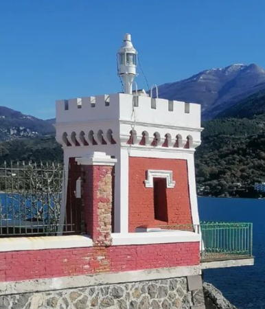
1915. Active; focal plane 13 m (43 ft); two white flashes every 7 s. A short post light with a small lantern, mounted atop a square 1-story masonry tower with castellated gallery. Lighthouse painted red with white trim; the gallery is white. A 2022 photo is at right, Trabas has a great photo, Ferrighi also has an excellent photo, Mimmo Benivento has a photo, Huelse has a historic postcard view, and Google has a street view and a satellite view. The lighthouse serves as a memorial to Carlo Pisacane, an Italian patriot and revolutionary who was killed in Campania in 1857. Located on the Via Verdi at Punta del Fortino on the west side of the entrance to the harbor of Sapri. Parking provided. Site open, tower closed. . ARLHS ITA-299; EF-2676; Admiralty E1746; NGA 9664.
* Scario
1883. Active; focal plane 24 m (79 ft); four white flashes every 12 s. 12 m (39 ft) octagonal cylindrical masonry tower with gallery, attached to the seaward side of a 2-story masonry keeper's house. Lighthouse painted white; lantern is gray metallic. Trabas has Capt. Peter's photo, Gianluca Amato has a closeup photo, Lisa Rita has a 2021 photo, and Google has a street view and a satellite view. Located on the Via Faro on the south side of the village of Scario, about 18 km (11 mi) west of Sapri. Site open, tower closed. . ARLHS ITA-079; EF-2672; Admiralty E1742; NGA 9660.
* Capo Palinuro
1870. Active; focal plane 206 m (676 ft); three white flashes every 15 s. 14 m (46 ft) octagonal cylindrical masonry tower with gallery, rising from a 2-story masonry keeper's house. Lighthouse painted white with three narrow gray-blue horizontal bands as trim. 3rd order Fresnel lens in use. Trabas has Capt. Peter's excellent photo (also seen at the top of this page), Marinas.com has aerial photos, and Google has a satellite view and a street view of the top of the tower. Capo Palinuro is a sharp and steep promontory projecting from the coast south of Palinuro. The area is rather wild, and a short hike may be needed to reach the lighthouse. Note: about 600 m (3/8 mi) east of the lighthouse is a weather station and former signal tower that is often mistaken for a second lighthouse. Site open, tower closed. Site manager: Parco Nazionale Cilento, Vallo di Diano e Alburni. ARLHS ITA-030; EF-2668; Admiralty E1740; NGA 9652.
Isolotto Licosa (Isola Licosa, Punta Licosa)
1951. Active; focal plane 13 m (43 ft); two white flashes every 10 s. 10 m (33 ft) round masonry tower with lantern and gallery, painted white. Ruins of a stone keeper's house are next to the lighthouse. Trabas has Eckhard Meyer's photo, Assunta Niglio has a 2021 photo, Marinas.com has aerial photos, and Google has an indistinct satellite view and a distant street view from the mainland. Isolotto Licosa is a small island just offshore from Punta Licosa, a mountainous cape projecting about 12 km (7.5 mi) into the Tyrrhenian Sea south of Agropoli. Most of the cape is included in a national park, the Parco Nazionale Cilento e Valle di Diano. Accessible only by boat. Site open, tower closed. . ARLHS ITA-089; EF-2664; Admiralty E1738; NGA 9636.

Sapri Light, Sapri, January 2022
Instagram photo by sonia_per_te
* Agropoli (Punta Fortino)
1923 (?). Active; focal plane 42 m (138 ft); two white flashes every 6 s. 10 m (33 ft) square cylindrical stone tower with lantern and an elaborately castellated gallery, rising from a 1-story brick building. The upper portion of the tower and gallery are painted white; the rest of the building is unpainted stone; lantern is gray metallic. A photo is at right, Trabas also has an excellent photo, Ella Civetta has a 2020 closeup, and Google has a satellite view. Located on a steep promontory overlooking the east side of the entrance to the harbor of Agropoli. Site open, tower closed. . ARLHS ITA-185; EF-2660; Admiralty E1735; NGA 9632.

Salerno Area Lighthouses
Salerno is a historic seaport facing the Gulf of Salerno, a broad embayment of the Tyrrhenian Sea. The city has a population of about 140,000.

#Salerno
Date unknown (1920s?). Inactive, probably since the 1970s; believed to have been demolished in 2010. 8.5 m (28 ft) round tower with lantern and gallery, painted white. A 2008 photo is available and Google has a satellite view of the area. The long-abandoned lighthouse was in poor condition, and it was probably demolished in 2010 in connection with construction of a new maritime terminal. We need information about this site. Located at what was once the end of a breakwater mole but is now the root of a much longer breakwater enclosing the modern harbor of Salerno. Site apparently open, tower closed. ARLHS ITA-298.
Salerno Molo di Levante
Date unknown. Active; focal plane 13 m (43 ft); green flash every 5 s. 10 m (33 ft) "bottle" style post light centered on an octagonal 1-story concrete equipment room. Lighthouse painted green. Trabas has Thomas Philipp's photo, Rosario Landi has a 2022 photo, and Google has a satellite view. In August 2021 the Admiralty reported that the two mole lights were temporarily extinguished and replaced by buoys during a project to extend this breakwater. The lights were relocated. Located at the end of the long east breakwater of Salerno harbor. Site status unknown. EF-2634; Admiralty E1730.2; NGA 9612.
Salerno Molo di Ponente
Date unknown. Active; focal plane 13 m (43 ft); red flash every 5 s. 10 m (33 ft) "bottle" style post light centered on an octagonal 1-story concrete equipment room. Lighthouse painted red. Trabas has Thomas Philipp's photo and Google has a satellite view. In August 2021 the Admiralty reported that the two mole lights were temporarily extinguished and replaced by buoys during a project to shorten this breakwater. The lights were relocated. . Located at the end of the long west breakwater of Salerno harbor. Site status unknown. EF-2635; Admiralty E1730.4; NGA 9616.
Faro d'Agropoli
Agropoli Light, Agropoli, November 2007
Wikipedia Creative Commons photo by Mujaidin
* Capo d'Orso (2)
1882 (station established 1862). Active; focal plane 66 m (217 ft); three white flashes every 15 s. 2-story stone keeper's house, with a white lantern mounted on a platform or porch in front of the house. The house is painted red with white trim. Trabas has Hartmut Knape's photo, a closeup photo is available, Mimmo Benivento has a view from the sea, and Google has a satellite view. The original lighthouse was much lower, with a focal plane of 25 m (82 ft). In 2015 the lighthouse was offered for sale and conversion to a boutique hotel. The lighthouse is in the midst of the famous Amalfi Coast, a scenic area that attracts tourists from around the world. Located clinging to the face of a a steep promontory at the western entrance to the Golfo di Salerno, just off the spectacular but challenging SS163 coastal highway about 4 km (2.5 mi) east of Maiori. Site open, tower closed. ARLHS ITA-019; EF-2628; Admiralty E1722; NGA 9600.
Isolotti Li Galli
Date unknown. Active; focal plane 67 m (220 ft); white flash every 5 s. 12 m (39 ft) square skeletal tower with gallery, rising from an equipment shelter. Lighthouse painted white. No closeup photo available; Trabas has Capt. Peter's photo and Google has a satellite view. The Isolotti Li Galli have an ancient history, as they were one of the sites where Greek sailors reported sirens, female creatures who lured sailors to their deaths on the rocks. Located on Il Gallo Lungo, the largest of the islands, off the south side of the Sorrentine Peninsula about 6.5 km (4 mi) southwest of Positano. The island is privately owned. Site and tower closed. ARLHS ITA-184; EF-2616; Admiralty E1716; NGA 9588.

Campania: Napoli Province Lighthouses

Isola di Capri Lighthouse
The famous Isle of Capri is a rather small island, about 5 km (3 mi) in length, located 4 km (2.5 mi) off the end of the Sorrento Peninsula. It has been a popular resort since Roman times. Part of Napoli Province, the island is easily accessible by ferry from Naples or Sorrento. In addition to the active Faro di Punta Carena, the ruins of what is often described as a Roman lighthouse can be seen at the Villa Jovis, a palace of the Emperor Tiberius located at the northeastern point of the island. However, from available accounts it appears that this structure was used primarily as a signal tower, sending messages to Rome via a similar tower at Capo Miseno.

*
Punta Carena (Capri)
1867. Active; focal plane 73 m (240 ft); white flash every 3 s. 28 m (92 ft) octagonal masonry tower with lantern and gallery, rising from a 2-story masonry keeper's house. 2nd order (?) Fresnel lens in use. Formerly buff and white, the lighthouse has been repainted recently and is now white with red vertical stripes; the keeper's house is red with white trim. The lantern is gray metallic. 1st order Fresnel lens in use. A photo is at right, Marianna Tisi has a 2021 photo, Tom Wachtel has a 2011 photo, Ferrighi has a photo, Trabas has a distant view by Capt. Peter, Mauro Primo has a 2021 view from the sea, Marinas.com has aerial photos, and Google has a street view and a satellite view. Serving as a landfall light for the Gulf of Naples, this historic lighthouse is one of the most important and most powerful in Italy. It occupies a spectacular site on a ridge with mountains towering behind. Located at the end of the Via Nuova dei Faro about 3 km (2 mi) southwest of Anacapri, at the southwestern tip of the island. Accessible by road, parking provided. Site open, tower closed. . ARLHS ITA-124; EF-2612; Admiralty E1706; NGA 9572.

Sorrento Peninsula Lighthouses
Punta Campanella (4?)
Date unknown (late 1960s?). Station established 1846. Active; focal plane 65 m (213 ft); white light, 2 s on, 3 s off. 18 m (59 ft) square skeletal tower with lantern and gallery. There is also a 1-story equipment shelter in the base of the tower. Tower painted with black and white horizontal bands; lantern is gray metallic. Trabas has a closeup photo, Gerard Schut has a photo, another photo is available, Wikimedia has a view from the sea, Robert Duivenvoorden has a street view, and Google has a satellite view. Ferrighi reports that this lighthouse replaced a brick tower that was destroyed by an explosion after a gas leak in the 1960s. Earlier lighthouses were built here in 1846 and in 1888; the original lighthouse had a focal plane of 23.5 m (77 ft). The lighthouse is adjacent to the Torre Minerva, a massive square defensive tower built around 1300 by Roberto il Saggio, an Angevin king of Naples. The surrounding area was formerly a military installation but since 1997 it has been a historic and natural preserve, the Area naturale marina protetta Punta Campanella. Located at the tip of the Sorrentine Peninsula about 3 km (2 mi) south of Marciano. There is currently no public road access to the site. Site and tower closed. . ARLHS ITA-243; EF-2593.3; Admiralty E1702; NGA 9568.

Punta Carena Light, Capri, May 2012
Flickr Creative Commons photo by Domiriel
* Castellammare di Stabia (Faro D'Atterraggio) (3)
Date unknown (station established before 1855). Active; focal plane 114 m (374 ft); two white flashes every 10 s. 16 m (52 ft) round tower with lantern and gallery, mounted atop a 3-story U-shaped building. Lighthouse painted white. Trabas has Capt. Peter's excellent closeup photo, Pio Negri has a photo, and Google has a street view and a good satellite view. Castellammare di Stabia, at the southeastern corner of the Golfo di Napoli, is only 6 km (3.5 mi) south of Pompeii and was one of the towns destroyed by the great eruption of Vesuvius in 79 BCE. The lighthouse is located on the Strada Panoramica overlooking the town and harbor. Site open, tower closed. ARLHS ITA-182; EF-2564; Admiralty E1692; NGA 9540.

Napoli (Naples) Lighthouses
Naples (Napoli in Italian) is the third-largest city in Italy with an urban population of about one million and a metropolitan population of more than three million. Settled by Greek sailors in the ninth century BCE it is one of the oldest continuously inhabited cities in the world; its central core is recognized as a UNESCO World Heritage Site. Under various rulers it was for centuries the capital of southern Italy and during the nineteen century, in the decades prior to the unification of Italy, it was the capital of the Kingdom of the Two Sicilies. An important seaport throughout its history, it faces the broad natural harbor of the Gulf of Naples.

* Portici (Granatello) (2)
Date unknown (station established 1889). Active; focal plane 16 m (52 ft); white flash every 3 s. 14 m (46 ft) square cylindrical skeletal tower with gallery. The tower is enclosed by silver-colored screening so that the tower appears from a distance to be enclosed. Trabas has Capt. Peter's closeup photo and Google has a street view and a satellite view. Located at the end of the quay in Portici, on the southeastern edge of Naples. Accessible by walking the quay. Site open, tower closed. ARLHS ITA-276; EF-2547; Admiralty E1678; NGA 9516.
Antemurale Thaon de Revel
Date unknown. Active; focal plane 18 m (59 ft); green flash every 4 s. 12 m (39 ft) round tower with lantern and gallery, mounted on a square stone base. Lighthouse painted green; the lantern dome is silvery metallic. Trabas has Capt. Peter's closeup photo (also seen at right), a 2007 photo is available, Michel Forand provided a historic photo, and Google has a satellite view. The main entrance to the harbor of Naples is between this lighthouse and the Molo di San Vincenzo. Located at the southwest end of a detached breakwater protecting the east side of the harbor. Accessible only by boat. Site and tower closed. ARLHS ITA-186; EF-2436; Admiralty E1648; NGA 9464.
Diga Duca degli Abruzzi (Molo di San Vincenzo Extension) (2)
Date unknown. Active; focal plane 15 m (49 ft); red flash every 3 s. 10 m (33 ft) square skeletal tower with gallery, painted red. Trabas has Capt. Peter's photo and Google has a satellite view. Michel Forand provided a historic photo of the original lighthouse, which was a sibling of the surviving Antemurale Thaon di Revel light. Located at the end of the extension of the Molo di San Vincenzo. Site and tower closed. ARLHS ITA-061; EF-2430.5; Admiralty E1647.5; NGA 9465.

Antemurale Thaon di Revel Light, Napoli
photo copyright Capt. Peter Mosselberger
used by permission
Molo di San Vincenzo (Napoli) (4)
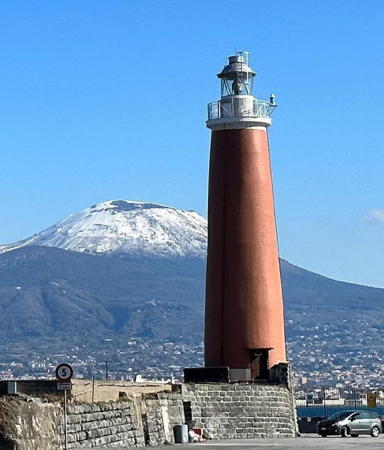
1916. Active; focal plane 25 m (82 ft); three white flashes every 15 s. 24 m (79 ft) round masonry tower with lantern and gallery, painted red with white trim; the lantern dome is gray metallic. A statue of San Gennaro stands near the lighthouse; the base of the statue carries two continuous red lights (EF-2442; Admiralty E1650; NGA 9476). A 2023 photo of the lighthouse and Mount Vesuvius is at right, Trabas has a fine photo by Capt. Peter, Wikimedia has a 2008 photo and a photo by Eric Salard, Nico Sebaste has a nice view from the sea, and Google has a satellite view. The architect Luca Bengiamo built the first Naples lighthouse in the 15th century. In 1843 a 43 m (141 ft) lighthouse was built on the Molo Beverello; it was demolished in the 1930s to make way for a harbor expansion. The present lighthouse was deactivated in 1979 after being damaged by a storm, but apparently it was not out of service for long. Michel Forand has a postcard view showing the keeper's house formerly attached to the lighthouse; the house was demolished in 1993. Located at the original end of the 1800 m (1.1 mi) long Mole di San Vincenzo, the main breakwater mole for the harbor of Naples. It does not appear that one can walk the mole. Site and tower closed. . ARLHS ITA-103; EF-2424; Admiralty E1646; NGA 9475.

Pozzuoli Lighthouses
Pozzuoli is a city of about 85,000 residents on the west edge of Naples, facing the north side of the Gulf of Naples.

Nisida (Isola di Nisida) (2?)
Date unknown (station established 1841). Inactive, perhaps since the 1970s. 10 m (33 ft) round masonry tower attached to a small keeper's house. Lighthouse painted white. The Navy has a page for the active post light (focal plane 14 m (46 ft); green flash every 3 s). Photos of the historic lighthouse are very scarce. Vezio Ricciardi has a 2021 photo, the tower can be seen at the far right of Enza Salamino's aerial photo, and Google has a satellite view and a very distant street view. Nisida is a small, volcanic island just off the coast of the Golfo di Napoli about 4 km (2.5 mi) southeast of Pozzuoli. The site of a NATO naval headquarters, much of the island is closed to the public. Located at an elbow of the breakwater mole on the north side of the island. Site and tower closed. EF-2416; Admiralty E1628.4; NGA 9400.
* Molo Caligoliano (Pozzuoli) (2)
Date unknown (station established 1860). Inactive since 2010. 10 m (33 ft) round cylindrical stone tower with gallery, mounted atop the 2-story square stone breakwater building. Lantern removed in 2010. The building is unpainted; the former light tower is painted green. Marco Visconti has a closeup photo, Stefano Gisonna has a street view, and Google has a good satellite view. This light was deactivated after the pier was extended. Located at an elbow near the end of the breakwater mole of Pozzuoli, and accessible by walking the mole. Site open, tower closed. ARLHS ITA-242.

Molo di San Vincenzo Light, Napoli, February 2023
Instagram photo by Grandenapoli.it
* Molo Caligoliano (Pozzuoli) (3)
2010 (station established 1860). Active; focal plane 11 m (36 ft); green light, 2 s on, 2 s off. 7 m (23 ft) round cylindrical stainless steel tower with lantern and gallery, mounted atop the 2-story square stone breakwater building. Lighthouse painted green; the lantern dome is gray metallic. Trabas has a good photo by Capt. Peter, a 2011 photo is available, and Google has a satellite view. The Resinex corporation prefabricated the lighthouse. Located at the end of the breakwater mole of Pozzuoli, and accessible by walking the mole. Site open, tower closed. EF-2410; Admiralty E1625; NGA 9390.
Fortino Tenaglia (Baia)
Date unknown (1950s? (station established 1856). Active; focal plane 13 m (43 ft); red light, 2 s on, 2 s off. 8 m (26 ft) round concrete tower with lantern and gallery, painted red. Trabas has Capt. Peter's photo, Wikipedia has a black-and-white closeup by Roberto De Martino, Aldo Amirante has a distant view, and Google has a satellite view. The Fortino Tenaglia is a small outpost associated with the Castello di Baia, a huge castle, one of the residences of the kings of Naples. Located on a small island, tenuously joined to the mainland by a sandbar, on the west side of the Gulfo di Pozzuoli, the bay sheltered by Capo Miseno. Site status unknown, but it may be possible to approach the lighthouse. . ARLHS ITA-297; EF-2406; Admiralty E1622; NGA 9384.
Capo Miseno (2)
1954 (station established 1869). Active; focal plane 80 m (262 ft); two white flashes every 10 s. 12 m (39 ft) round masonry tower attached to the seaward corner of a 2-story masonry keeper's house. Lighthouse painted white with black trim; lantern dome is gray metallic. A 2020 photo is at right, Trabas has Capt. Peter's photo, Diego Menna has a photo, Antonio Salsano has a view from the sea, and Google has a satellite view. Capo Miseno, a spectacular tall headland, is the western end of the Golfo di Napoli (Gulf of Naples). The lighthouse was destroyed in World War II and reconstructed after the war. The area surrounding the light station is a park, the Parco Regionale dei Campi Flegrei. Located at the end of the Via Faro in Monte di Procida. Site and tower closed. . ARLHS ITA-027; EF-2402; Admiralty E1620; NGA 9380.

Capo Miseno Light, Napoli, October 2020
Instagram photo by panoramilandscape

Ischia and Procida Lighthouses
Ischia is a volcanic island at the western end of the Gulf of Naples, and Procida is a smaller island lying between Ischia and the mainland at Capo Miseno. Both islands are readily accessible by ferry from Pozzuoli and Naples. The islands are attached to Napoli Province.

Punta Pioppeto
1849. Active; focal plane 21 m (69 ft); three white flashes every 10 s. Approx. 8 m (26 ft) post atop a square 1-story equipment building. Building painted white. 1-1/2 story masonry keeper's house. Emanuele Cigliuti has a closeup photo, Trabas has Capt. Peter's photo showing the post atop the building, Alberto Zinesi has a 2017 photo, and Google has a satellite view. The light marks the western entrance to the narrow passage between Procida and Capo Miseno on the mainland. Located on a promontory at the northern tip of Procida, beyond the end of the Via dei Faro. Site status unknown. ARLHS ITA-296; EF-2358; Admiralty E1618; NGA 9364.
* Casamicciola Inner Mole
Date unknown. Active (privately maintained); focal plane 7 m (23 ft); continuous red light. 5 m (18 ft) octagonal stone tower topped by a statue of the Virgin; the light is at the Virgin's feet. Trabas has Capt. Peter's photo, a 2021 photo is available, and Google has a satellite view. Located on the west (inner) breakwater of Casamicciola, a small port on the central north coast of Ischia. Accessible by walking the pier. Site open, tower closed. Admiralty E1606.2; NGA 9341.
* Porto d'Ischia (Molo Bagno)
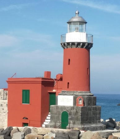
1868. Active; focal plane 13 m (43 ft); flash every 3 s, white or red depending on direction. 11 m (36 ft) round masonry tower with lantern and gallery, mounted on a square concrete block base. There is a small square equipment shelter next to the tower. Tower and shelter painted red, lantern white with a gray metallic dome. László Valusek's photo is at right, 2009 photo is available, Trabas has Capt. Peter's photo, Marco Viano is a closeup, a nice panoramic view is available, and Google has a satellite view. According to the Faro di Han web site, the lighthouse was built in 1854 but not activated until 1868. Located at the end of the breakwater mole sheltering the harbor of Porto d'Ischia, at the northeast corner of the island; there's a great view from ferries arriving from Naples. Accessible by walking the mole. Site open, tower closed. ARLHS ITA-262; EF-2374; Admiralty E1608; NGA 9344.
Castello d'Ischia
1913. Active; focal plane 82 m (269 ft); white light, 2 s on, 4 s off. Gray metallic lantern mounted on the seaward rampart of a 15th century Aragonese castle. The light is seen left of center in Carlo Pelagalli's photo of the castle and Google has a satellite view. Alfonso of Aragon built the castle around 1441 atop the foundations of earlier Roman and Greek fortifications. Built atop a conical island just off the easternmost tip of Ischia, the castle is connected to the mainland of the Ischia by a causeway. Tours of the historic castle are available, but the upper section with the lighthouse is closed. Site and tower closed, although the lighthouse can be seen from below. ARLHS ITA-178; EF-2370; Admiralty E1614; NGA 9356.
Punta Imperatore (2)
1916 (station established 1884). Active; focal plane 164 m (538 ft); two white flashes every 15 s. 13 m (43 ft) round cylindrical masonry tower attached to the seaward side of a 2-story masonry keeper's house. Lighthouse painted white; lantern dome is gray metallic. Trabas has Capt. Peter's photo, a 2006 photo is available, there is a distant view of the site, Gaetano Sensale has a view from above, Leonardo Luzzi has a view from below, and Google has a satellite view. Sarah Maldito's 2018 photo shows a small lantern in the ground in front of the historic lighthouse. The light serves as a landfall light for Naples. Located atop a tall, spectacular headland at the western tip of Ischia. Site status unknown. ARLHS ITA-132; EF-2398; Admiralty E1598; NGA 9328.

Molo Bagno Light, Porto d'Ischia, October 2019
Google Maps photo by László Valusek

Lazio: Latina Province Lighthouses

Pontine Islands Lighthouses
The Pontine Islands (Isole Ponziane) are a group of small islands of volcanic origin located in the Tyrrhennian Sea south of Gaeta. Although the islands were historically ruled by the Kingdom of Naples they are now attached to the region of Lazio as part of Latina Province. The two larger islands, Ponza and Ventotene, are popular resorts accessible by passenger ferry from Formia, Terracina, and Anzio.
* Ventotene (Porto Nicolo) (2)
1891 (station established 1869). Active; focal plane 21 m (69 ft); white flash every 5 s. 16 m (52 ft) round tower with lantern and gallery attached to a 1-story keeper's house. Lighthouse painted white; lantern dome is gray metallic. There's a photo at right, a 2011 closeup photo is available, Trabas has Capt. Peter's photo, Marinas.com has aerial photos, Matyas Rathonyi has a street view, and Google has a satellite view of the station. Located on the waterfront of Porto Nicolo, where it greets travelers arriving on the island of Ventotene. Site open, tower closed. . ARLHS ITA-172; EF-2286; Admiralty E1592; NGA 9320.
Isola di Ponza (Scoglio Ravia)
Date unknown. Active; focal plane 26 m (85 ft); green flash every 3 s. 6 m (20 ft) post light centered on a square stone tower adjoining a large 1-story building. Lighthouse painted green, adjoining building white. Trabas has Capt. Peter's closeup photo, a 2022 distant view is available, and Google has an indistinct satellite view. Located atop a large rock on the north side of the entrance to the harbor of Ponza. Accessible only by boat. Site status unknown. EF-2271; Admiralty E1582; NGA 9240.
* Porto di Ponza (2)
1918 (station established 1867). Active; focal plane 12 m (39 ft); yellow flash every 3 s. 12 m (39 ft) octagonal cylindrical concrete tower with lantern and gallery, attached to a 1-story waterfront restaurant. Lighthouse painted orange with white trim; lantern dome is gray metallic. Trabas has Capt. Peter's photo, a closeup and a second closeup are available, Gennaro Buonecore has a photo of the lighthouse in action, and Google has a street view and a satellite view. This lighthouse greets travelers arriving on the island of Ponza by ferry. The original light was described as a red tower, 10 m (34 ft) tall. Located at the end of the Molo Musco, the short breakwater mole protecting the harbor of Porto di Ponza, on the southeastern coast of the island. Site open, tower closed. Site manager: Il Faro Café. ARLHS ITA-240; EF-2274; Admiralty E1584; NGA 9232.

Porto Nicolo Light, Ventotene, August 2008
Flickr Creative Commons photo by Marilena
* Rotonda della Madonna (2)
1959 (station established 1858). Active; focal plane 61 m (200 ft); four white flashes every 15 s. 18 m (59 ft) round, bluntly conical concrete tower with lantern and gallery, painted white; lantern dome is gray metallic. Adjoining 3-story keeper's house. Trabas has Capt. Peter's photo, Marinas.com has aerial photos and Google has a street view and a satellite view. This lighthouse is only a short (albeit steep) hike from the Porto di Ponza waterfront. Located on a very steep promontory on the island of Ponza, about 600 m (3/8 mi) east of Porto di Ponza. Site open, tower closed. ARLHS ITA-215; EF-2266; Admiralty E1580; NGA 9228.
* Punta della Guardia (2)
1886 (station established 1866). Active; focal plane 112 m (367 ft); three white flashes every 30 s. 18 m (59 ft) octagonal cylindrical masonry tower with lantern and gallery, rising from a 2-story keeper's house. Lighthouse painted white with two horizontal red bands on the keeper's house; lantern dome is gray metallic. Vincenzo Fricchione's photo is at right, Giancarlo Giuppone Trentino has a fine photo, Trabas has Capt. Peter's photo, Roberto Miliani has a photo, Francesco Bruno has a view from the sea, Marinas.com has aerial photos, and Google has a satellite view. The original light was much higher, at a focal plane of 226 m (741 ft). Located at the south end of the Isola di Ponza, this lighthouse can be reached by a hike of about 3 km (2 mi) one way. The scenery is spectacular: Huelse's postcard view shows how the lighthouse is perched atop a giant rock connected to the rest of the island by a very narrow isthmus. Site open, tower closed. ARLHS ITA-277; EF-2278; Admiralty E1588; NGA 9224.
Zannone (Capo Negro)
1858. Active; focal plane 37 m (121 ft); three white flashes every 10 s. 13 m (43 ft) octagonal masonry tower with lantern and gallery, rising from a 1-story keeper's house. Entire lighthouse painted white; lantern dome is gray metallic. Trabas has Capt. Peter's photo, Guyomard and Carceller have a nice view from the sea by Laure Chappuis and Bing has a satellite view. Zannone is a small, uninhabited island about 25 km (15 mi) due south of Cabo Cercio. The island is part of Circeo National Park. Daytime visits to the island are permitted, but camping overnight is prohibited. Located on the northern point of the island. Accessible only by boat. Site open, tower closed. Site manager: Parco Nazionale del Circeo. ARLHS ITA-210; EF-2262; Admiralty E1577; NGA 9216.
Faro della Guardia
Punta della Guardia Light, Ponza, July 2008
ex-Panoramio photo copyright Vincenzo Fricchione
used by permission

Gaeta Lighthouses
Gaeta is a small port of about 25,000 residents. NATO's Mediterranean naval headquarters is located nearby at Monte Orlando.

* Punta dello Stendardo
Date unknown. Active; focal plane 20 m (66 ft); two red flashes every 10 s. 6 m (20 ft) round masonry tower with lantern and gallery mounted atop a 2-story concrete building. Tower painted bright red; lantern dome is silvery metallic; the building is unpainted gray concrete. Trabas has Capt. Peter's closeup photo (also seen at right) and Google has a satellite view. Located at the end of a pier at the extreme tip of the cape east of Gaeta. Site open, tower closed. ARLHS ITA-248; EF-2320; Admiralty E1560; NGA 9268.
* Monte Orlando (Gaeta) (3)
1954 (station established 1854). Active; focal plane 185 m (607 ft); three white flashes every 15 s. 14 m (46 ft) round cylindrical masonry tower with lantern and gallery. The lighthouse is painted white, but with unpainted cinder bricks giving the appearance of gray and white vertical stripes. The lantern is gray metallic. Trabas has an excellent photo, Bruno Montemurro has a 2021 photo, a 2009 photo is available, Huelse has a postcard view, and Google has a street view and a satellite view. The original light was placed on the tower of the Cistercian convent of Santa Catherina. The second light, built in 1888, was a 26 m (85 ft) tower. Both the earlier lights were much lower on the slope. Located on the cape in the Parco Urbano Monte Orlando in Gaeta, about 80 km (50 mi) northeast of Naples. May not be accessible by road, but walking paths in the park reach the lighthouse. Site open, tower closed. ARLHS ITA-105; EF-2315; Admiralty E1558; NGA 9264.

Terracina Lighthouse
* Porto Badino
Date unknown. Inactive for many years. 6 m (20 ft) round stone tower with a ruined square lantern mounted atop the Torre Badino, a seventeenth century fortified stone tower. Luigi Strano has a photo and Google has a street view and a satellite view. The Torre Badino was built around 1610 under the orders of Pope Paul V. Today the tower is owned by a yacht club. We need information on the lighthouse; it is missing from the 1879 and 1904 light lists and was probably active for only a brief period in the early 1900s. Located on a hill on the west side of the mouth of the river Portatore in Terracina. Site open, tower closed. Site manager: Torre Badino Yachting Club.

Punta dello Stendardo Light, Gaeta
photo copyright Capt. Peter Mosselberger; used by permission
San Felice Circeo Lighthouse
* Capo Circeo (Monte Circeo)
1866. Active; focal plane 38 m (125 ft); white flash every 5 s. 18 m (59 ft) round masonry tower with lantern and gallery, attached to the seaward end of a 2-story masonry keeper's house. Entire lighthouse painted white; lantern dome is gray metallic. A 2022 photo appears at the top of this page, Trabas has a fine photo, Marco Fanan has a 2021 photo, Huelse has a historic postcard view, and Google has a street view and a satellite view. Like the Anzio lighthouse, this light was ordered by Pope Leo IX before the annexation of the Papal States into Italy. Located on the point of the cape in San Felice Circeo, a town about 55 km (34 mi) southeast of Anzio. Site open, tower closed. . ARLHS ITA-009; EF-2258; Admiralty E1542; NGA 9244.
Foce Verde Pierhead
Date unknown (around 1962?). Active; focal plane 14 m (46 ft); two yellow flashes every 6 s. 9 m (30 ft) post light adjacent to a concrete pierhead building. Post painted yellow, building unpainted. Trabas has Capt. Peter's photo. The pier was built for the Foce Verde nuclear power plant, which was deactivated in 1986. According to Silvio Dell'Acqua, who visited the area in 2010, the pier was used for a number of years by the Italian Air Force for rescue training. Dell'Acqua also reports that local residents told him the pier is scheduled to be demolished in the near future. Sure enough, Google's satellite view shows that most of the pier was removed, but its head with the light was preserved. Located at the end of the pier at Foce Verde. Admiralty E1541.6; NGA 9212.

Lazio: Metropolitan City of Rome Lighthouses

Nettuno and Anzio Lighthouse
Anzio is a fishing port and ferry terminal about 50 km (30 mi) south of Rome. During World War II was the scene of a long and bloody battle in the winter and spring of 1944. The city has a population of about 60,000. Nettuno is a town of about 50,000 residents on the east side of Anzio.
 
Nettuno East Outer Mole
Date unknown. Active (privately maintained); focal plane 11 m (36 ft); green light, 1.5 s on, 3.5 s off. 8 m (26 ft) round concrete tower painted green. Trabas has Capt. Peter's closeup photo, Fabio Bartolucci has a 2008 photo showing the tower painted with narrow green and white horizontal bands, Pietro Bergamaschini has a 2014 photo showing the tower solid green but with a lantern since removed, Giorgio Bruschini has a 2016 street view of the two mole lights, and Google has a satellite view. Located on the east outer breakwater of the yacht harbor of Nettuno. Accessible only by boat (the pier is not walkable). Site open, tower closed. Owner/site manager: Marina di Nettuno. Admiralty E1541.2; NGA 9208.
Nettuno West Outer Mole
Date unknown. Active (privately maintained); focal plane 11 m (36 ft); red light, 1.5 s on, 3.5 s off. 8 m (26 ft) round concrete tower painted red, adjoining a 1-story semicircular equipment shelter. Trabas has Capt. Peter's closeup photo, Eduard Peter has a 2009 photo showing the tower painted with narrow red and white horizontal bands and with a lantern, Pietro Bergamaschini has a 2014 photo showing the tower solid red but with the lantern, Giorgio Bruschini has a 2016 street view of the two mole lights, and Google has a satellite view. Located on the east outer breakwater of the yacht harbor of Nettuno. Accessible only by boat (the pier is not walkable). Site open, tower closed. Owner/site manager: Marina di Nettuno. Admiralty E1541.3; NGA 9204.
* Anzio (Capo d'Anzio)
1870. Active; focal plane 37 m (121 ft); two white flashes every 10 s. 21 m (69 ft) round cylindrical masonry tower with lantern and gallery, attached to a 2-story masonry keeper's house. Entire lighthouse painted white; lantern dome is gray metallic. Marina Kuzovleva has the 2019 photo seen at right, Trabas has an excellent photo, Kazik Zrazik has a 2022 photo, Wikimedia has a 2008 photo, R. Damiano has a good 2006 photo, Lighthouse Digest has Michel Forand's historic postcard view, and Google has a street view and a satellite view. Historically the lighthouse and keeper's house were painted with black and white horizontal bands, as seen in Huelse's postcard view. Ordered by Pope Leo IX, this lighthouse was completed in 1866 but remained unlit until the Papal States were joined to Italy in 1870. The lighthouse escaped destruction in World War II because the surprise Allied invasion of Anzio in January 1944 chased German troops before they could dynamite the tower. Located on the point of the cape in Anzio, a town 53 km (33 mi) south of Rome. Site open, tower closed. . ARLHS ITA-012; EF-2246; Admiralty E1538; NGA 9192.

Capo d'Anzio Light, Anzio, August 2019
Google Maps photo by Marina Kuzovleva

Ostia and Fiumicino (Rome Area) Lighthouses
Ostia and Fiumicino are comunes of the Metropolitan City of Rome facing the Tyrrhenian Sea. Ostia is on the east side of the mouth of the Tiber River and Fiumicino is on the west side. Ostia was the port of ancient Rome and Fiumicino is the modern port.

* Lido di Ostia East Mole
Date unknown. Active (privately maintained); focal plane 10 m (33 ft); green flash every 4 s. 5 m (17 ft) round cylindrical concrete tower with gallery, painted green. Trabas has a closeup, another photo is available, Di Giacomo Paolo has a 2021 photo, and Google has a satellite view. This light and the next guard the entrance to a modern marina built at Ostia to accommodate tourists visiting Rome. Located at the end of the east breakwater of the marina; accessible by walking the mole. Site open, tower closed. Operator/site manager: Porto Turistico di Roma. Admiralty E1530.
* Lido di Ostia West Mole
Date unknown. Active (privately maintained); focal plane 10 m (33 ft); red flash every 4 s. 5 m (17 ft) round cylindrical concrete tower with gallery, painted red. Trabas has a closeup, another photo is available, Davide Danti has a 2020 view from the sea, and Google has a satellite view. Located at the end of the west breakwater of the marina; accessible by walking the mole. Site open, tower closed. Operator/site manager: Porto Turistico di Roma. Admiralty E1531.
* Fiumicino (Fiumare Grande, Torre San Michele) (2?)
1860. Inactive since about 1910. 18 m (59 ft) octagonal stone fortress crowned by an octagonal stone tower. Aldo Ferretto has a 2021 photo, a 2017 closeup photo is available, Huelse has a postcard view of the tower while it was an active lighthouse, and Google has a street view and a good satellite view. The fortress was built in the mid 16th century by Popes Pius IV and Pius V. Located above the south bank of the Tiber on the Via degli Atlantici, about 2.5 km (1.5 mi) east of the 1946 lighthouse (next entry). Site open, tower status unknown.
* Fiumicino (Fiumare) (5?)
1946 (station established 1825). Inactive since 1971. Approx. 17 m (56 ft) octagonal masonry tower attached to a 2-story keeper's house. The lighthouse was painted with red and white horizontal bands, although the colors have faded now. Gianluca Belardelli's photo is at right, Stefano Sauli has a 2022 photo, another photo is available, Huelse has a postcard view, and Google has a street view and a good satellite view. Huelse also has a postcard view of the 60 m (197 ft) tall lighthouse that stood at Fiumicino before World War II. It was destroyed by retreating German troops, and the present lighthouse was built on its foundations. The building was abandoned in 1971 because of structural problems and because the modern port entrance has been moved about 2.5 km (1.5 mi) north. It is probably endangered. Located at the end of the Via del Faro, on the north side of the mouth of the Tiber River. Site closed, but the lighthouse can be viewed from outside the fence. . ARLHS ITA-202.

Civitavecchia Lighthouses
Civitavecchia ("Ancient Town") is a seaport of about 55,000 residents at the northwestern corner of the Metropolitan City of Rome. It is indeed ancient, having been founded by the Emperor Trajan in the second century CE.

* Civitavecchia (3) (Monte Cappuccini)
1951. Active; focal plane 125 m (410 ft); two white flashes every 10 s. 30 m (98 ft) U-shaped tapered masonry tower with lantern and gallery, rising through the center of a curved 2-story keeper's house. The tower is unpainted gray stone; lantern gray metallic; house painted white. Trabas has a good photo by Capt. Peter, Gianluca Galizia has a 2018 photo, and Google has a street view and a satellite view. This lighthouse replaced the historic Civitavecchia lighthouse after World War II. Located on the Via Francesco Chiricozzi, atop a hill about 2.5 km (1.5 mi) west of the harbor of Civitavecchia. Site closed, but the lighthouse can be viewed from outside the fence. . ARLHS ITA-322; EF-2188; Admiralty E1508; NGA 9132.
* Civitavecchia (Fortino di San Pietro) (2)
1616. Inactive since about 1940. Once-tall round stone tower in ruins; about 13 m (43 ft) of the tower remain. Tomasz Telma has a 2019 photo, Luis Payo has a drone view, and Google has a satellite view. In 108 CE the Roman Emperor Trajan built two lighthouses at Centumcellae, now Civitavecchia, a city about 50 km (30 mi) northwest of Rome. In 1616 Pope Pius V built a new lighthouse on the foundation of one of the Roman towers, and in 1860 Pope Leo IX had a second-order lantern installed on the tower. Huelse has a postcard view of the lighthouse, which was 32 m (105 ft) tall. The lighthouse was destroyed during World War II. After the war, a 20 m (66 ft) round stone tower was built as a historic landmark on the modern breakwater, about 600 m (3/8 mi) northwest of the old lighthouse. Google has a satellite view of that tower. However, this "replica" does not resemble the original and is at best a faux lighthouse. The ruins of the historic lighthouse are located on a short abandoned mole on the old waterfront of Civitavecchia. Site open, tower closed.

Fiumicino Light, Fiumicino, September 2018
ex-Google Plus photo by Giovanna Fasciani

Information available on lost lighthouses:

Notable faux lighthouses:

Adjoining pages: North: Tuscany | South: Calabria and Basilicata

Return to the Lighthouse Directory index | Ratings key

Posted June 16, 2006. Checked and revised February 29, 2024. Lighthouses: 47. Site copyright 2024 Russ Rowlett and the University of North Carolina at Chapel Hill.