Lighthouses of the United States: Mississippi

The United States of America is a federal union of 50 states and a capital district. The state of Mississippi is in the southeast, located on the east bank of the Mississippi River. Spain gave up its claims to most of the area in a 1795 treaty and the U.S. forcibly annexed the coastal region in 1812. Mississippi was organized as a territory in 1798 and admitted as a state of the Union in 1817.

Mississippi has a short coastline facing the Gulf of Mexico northeast of New Orleans, Louisiana. The state's coast is low and sandy, with a partial fringe of barrier islands offshore. Pascagoula is the most important port on the coast.

On 29 August 2005 Hurricane Katrina devastated the coastline of Mississippi with one of the highest storm surges on record. The Biloxi lighthouse withstood the storm, as it has so many others, but there was significant damage to its interior brick lining. The Ship Island lighthouse replica was destroyed. The Round Island Light, which had been under restoration after being overturned by Hurricane Georges in 1998, was overturned a second time. This left Mississippi with only a single standing historic lighthouse. Since this disaster, the Round Island Light has been rebuilt at an onshore site in Pascagoula and Gulfport has built a marina lighthouse inspired by the Ship Island Light.

Navigational aids in the United States are operated by the U.S. Coast Guard, but ownership (and sometimes operation) of historic lighthouses has been transferred to local authorities and preservation organizations in many cases. Mississippi lights are the responsibility of the Coast Guard's Sector Mobile based in Mobile, Alabama

ARLHS numbers are from the ARLHS World List of Lights. Admiralty numbers are from volume J of the Admiralty List of Lights & Fog Signals. USCG numbers are from Volume IV of the U.S. Coast Guard Light List.

General Sources
Mississippi Lighthouses
Photos and historical accounts by Kraig Anderson.
Online List of Lights - Mississippi
Photos by various photographers posted by Alexander Trabas.
Lighthouses in Mississippi
Photos by various photographers available from Wikimedia.
Lighthouses and Islands of the Gulf
Articles about historic lighthouses of the Pass Christian area, written and posted by Dan Ellis.
Leuchttürme USA auf historischen Postkarten
Historic postcard images posted by Klaus Huelse.
U.S. Coast Guard Navigation Center: Light Lists
The USCG Light List can be downloaded in pdf format.
NOAA Nautical Charts
Nautical charts for the coast can be viewed online.
Navionics Charts
Navigation chart for Mississippi.
 

Biloxi Light
Biloxi Light, Biloxi, June 2010
Flickr Creative Commons photo by Natalie Maynor

Jackson County (Pascagoula Area) Lighthouses
Pascagoula Range D Rear (Petit Bois Island)
Date unknown. Active; focal plane 60 ft (18 m); white light, 3 s on, 3 s off, visible only on the range line. 59 ft (18 m) triangular skeletal tower. The tower carries a rectangular daymark colored red with a white vertical stripe. Tim Smith has a distant street view and Google has a satellite view. This light is close to the former location of the Petit Bois Island lighthouse. The range guides outbound vessels on the approach to the narrow Horn Island Pass. Located on the west end of Petit Bois Island. Accessible only by boat. Site open, tower closed. Admiralty J3561.1; USCG 4-7970.
Horn Island Pass Range Rear (?)
1961. Active; focal plane 94 ft (29 m); white light, 3 s on, 3 s off, visible only on the range line. There is also a passing light, white flash every 4 s, at a focal plane of 40 ft (12 m). 94 ft (29 m) 2-stage skeletal tower, lower part square and upper part triangular, mounted on a square platform supported by piles. The tower carries a rectangular daymark colored red with a white vertical stripe. No photo available but Google has a satellite view. This is the approach range for vessels arriving in Pascagoula. Horn Island Pass, the channel between Petit Bois Island to the east and Horn Island to the west, provides the entrance to Pascagoula. The pass was marked by the Horn Island lighthouse from 1874 to 1906, and then by the Petit Bois Island lighthouse from 1908 until the range was established in 1961. Lighthouse Digest has Timothy Harrison's July 2011 article on the history of these lights. Located in Mississippi Sound off the northwestern tip of Petit Bois Island. Accessible only by boat. Site open, tower closed. Admiralty J3558.1; USCG 4-7900.
Pascagoula Range B Rear
Date unknown. Active; focal plane 64 ft (19.5 m); white light occulting once every 4 s, visible only on the range line. 64 ft (19.5 m) tapered triangular skeletal tower, mounted on a square platform supported by piles. There is also a passing light, white flash every 4 s, at a focal plane of 12 ft (3.5 m). The tower carries a rectangular daymark colored red with a white vertical stripe. Trabas has a distant view and Bing has a satellite view. This is an outbound range for vessels leaving Pascagoula. Located in Mississippi Sound about halfway between the Pascagoula waterfront and Petit Bois Island. Accessible only by boat. Site open, tower closed. Admiralty J3564.1; USCG 4-8100.
* Bayou Casotte Range A Rear
Date unknown. Active; focal plane 83 ft (25 m); green light by night and white light by day, 3 s on, 3 s off, visible only on the range line. Approx. 75 ft (23 m) triangular cylindrical skeletal tower. Trabas has a photo and Google has a street view and a satellite view. Bayou Casotte is an industrial harbor basin on the east side of Pascagoula. Located in an industrial area on the west side of the bayou. Site and tower closed, but the light is seen at the end of Bayou Casotte Parkway. Admiralty J3571.31; USCG 4-8400.
Bayou Casotte Range D Rear
Date unknown. Active; focal plane 55 ft (17 m); white light 3 s on, 3 s off, intensified on the range line. 55 ft (17 m) tapered triangular skeletal tower, mounted on a square platform supported by piles. There is also a passing light, white flash every 4 s, at a focal plane of 14 ft (4 m). The tower carries a rectangular daymark colored red with a white vertical stripe. No photo available but Bing has a distant satellite view. This is an outbound range for vessels leaving Bayou Casotte. Located in Mississippi Sound a short distance west of the Range B Light. Accessible only by boat. Site open, tower closed. Admiralty J3571.33; USCG 4-8410.
Pascagoula Range A Rear
Date unknown. Active; focal plane 95 ft (29 m); red light by night and white light by day, 3 s on, 3 s off, visible only on the range line. There is also a passing light, white flash every 4 s, at the same focal plane. 59 ft (18 m) 2-stage skeletal tower, lower part square and upper part triangular, mounted on a square platform supported by piles. The tower carries a rectangular daymark colored red with a white vertical stripe. Trabas has a photo and Google has a satellite view. This is the entrance range guiding vessels into Pascagoula. Located in Mississippi Sound about 2 miles (3 km) south of the Pascagoula waterfront and 3 miles (5 km) east of Round Island. Accessible only by boat. Site open, tower closed. Admiralty J3562.1; USCG 4-7995.
** Round Island (2) (relocated and rebuilt)
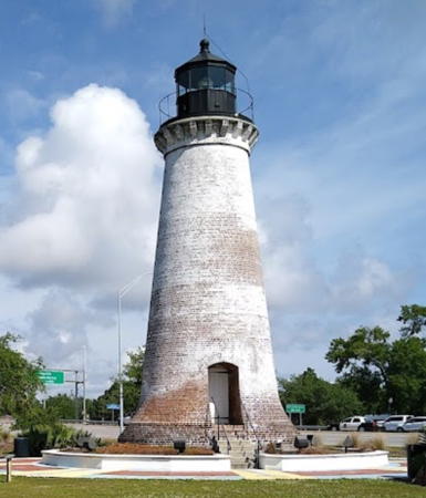
1859 (station established 1833). Inactive since 1944 (a decorative white light is displayed). 50 ft (15 m) brick tower with lantern, painted white; lantern painted black. Christopher Mardorf's April 2015 photo is at right, Marty McFly has a 2022 photo, Anna Wright-Heatherly has a 2021 photo, and Google has a street view and a satellite view. The lighthouse was built on an island about 2 mi (3.2 km) south of Pascagoula harbor. Google has a satellite view of the former location of the lighthouse, the Coast Guard has a historic photo of the station taken in 1892 and Huelse has a historic postcard view. Anderson's photos show the lighthouse as it appeared in 1998, but on September 27 of that year the lighthouse was overturned by Hurricane Georges. The Round Island Lighthouse Preservation Society was quickly formed to carry out a restoration. In 1999 the overturned lighthouse base was righted and stabilized with a steel caisson. In March 2000 a protective breakwater was completed. This work came to nought in 2005 when Hurricane Katrina overturned the lighthouse a second time, washing out the caisson. This put an end to the effort to rebuild the lighthouse on its original location; it was decided to rebuild it onshore in Pascagoula. In August 2009 Pascagoula City Council approved rebuilding the lighthouse on the east side of the Pascagoula River just south of the US 90 bridge. In December the state Department of Archives and History agreed to allow a previously-awarded grant of $250,000 to be used for the reconstruction. The reconstruction is in concrete faced with as much of the original brick as could be salvaged. Work began in 2010; in mid-July the salvaged base of the lighthouse arrived at the new site and in December it was installed on its new foundation. In July 2012 the replica lantern also arrived on the site. In August the city awarded a $636,000 contract to complete the rebuilding. In May 2013 the replica of the original lantern was installed and by the end of July the brickwork was complete. Google has a July 2013 street view of the reconstruction then ongoing. The lighthouse was rededicated in October 2013. In September 2014 the city council approved a $166,485 project to complete the interior of the lighthouse. Work was underway in October 2014 and was completed during 2015; a grand opening was held on 13 November. In early 2016 the city was seeking a part-time keeper and tour guide for the lighthouse. In 2020 a $475,000 state grant provided funds for additional amenities in Lighthouse Park. Located in a city park on the east side of the Pascagoula River just south of the US 90 bridge. The nearest public parking is at the Frederic Street Boat Ramp two long blocks to the west. Site open, tower open for guided tours on Fridays and Saturdays. Owner/site manager: City of Pascagoula (Round Island Lighthouse ) ARLHS USA-711.
Pascagoula Range C Front
Date unknown. Active; focal plane 65 ft (20 m); flash every 2.5 s, red at night and white in the daytime. 59 ft (18 m) triangular skeletal tower. Trabas has a photo and Google has a satellite view. This is the entrance range for Pascagoula harbor. Located in the Ingalls Shipbuilding shipyard on the west side of the Pascagoula River. Site and tower closed. Site manager: Ingalls Shipbuilding. Admiralty J3566; USCG 4-8110.

Reconstructed Round Island Light, Pascagoula, April 2015
U.S. FEMA public domain photo by Christopher Mardorf
Pascagoula Range C Rear
Date unknown. Active; focal plane 122 ft (37 m); continuous red light. 115 ft (35 m) triangular skeletal tower. Trabas has a photo and Google has a satellite view and a distant street view from the bridge to Singing River Island. Located in the Ingalls Shipbuilding shipyard on the west side of the Pascagoula River. Site and tower closed. Site manager: Ingalls Shipbuilding. Admiralty J3566.1; USCG 4-8115.

Harrison County (Biloxi and Gulfport Area) Lighthouses
*** Biloxi
1848. Active (maintained by City of Biloxi); focal plane 61 ft (18.5 m); white light occulting every 4 s. 61 ft (18.5 m) cast iron tower (brick lined), 5th order Fresnel lens (1926). Entire structure painted white, except for the black balustrade. The keeper's houses were destroyed by Hurricane Camille in 1969. Natalie Maynor's photo is at the top of this page, the City of Biloxi has a web page for the lighthouse and a portfolio of photos, Trabas has Michael Boucher's photo, Jianxin Gao has a fine 2016 photo, Sarah German has a 2022 photo, Wikimedia has photos, the Coast Guard has an 1892 photo, Huelse has a historic postcard view, and Google has a street view and a satellite view. This is the second-oldest cast iron lighthouse in the U.S. The tower interior was restored in 1990 but the tower was closed in 2002 due to safety concerns. In August 2003 a consultant's report recommended resumption of tours with certain safety restrictions. The tower had been scheduled to reopen in the fall of 2005 but the destruction of most of the city of Biloxi by Hurricane Katrina put these plans on indefinite hold. The day after the hurricane, someone fastened a U.S. flag to the gallery rail, as shown at right. The flag continued to fly there for four years as a symbol of the city's determination to rebuild. Although the lighthouse survived the hurricane its interior brick lining was damaged and required extensive repair. Although federal disaster relief funds were available for this work there was a lengthy period of planning and negotiation. Work finally began in the summer of 2009 and was completed in early 2010. The lighthouse was relit in ceremonies on February 19. Meanwhile the city bought land across the street, where the hurricane had destroyed all the structures, for a lighthouse park and Visitors Center . Work on that facility began in late 2009 and and the center opened in August 2011. The lighthouse stands in the median of US 90 at the foot of Porter Street in Biloxi, just west of the I-110 interchange. Parking is available, but be careful crossing the busy street. Site and visitor center open daily; tower open for tours in the early morning (9:00-9:30 am) daily year round, weather permitting. Owner/site manager: City of Biloxi (Biloxi Lighthouse). . ARLHS USA-056; Admiralty J3578; USCG 4-8955.
Biloxi Light after Katrina
Biloxi Light flies the U.S. flag after Hurricane Katrina, 31 August 2005
City of Biloxi photo
* Broadwater Beach
1965(?). Active (privately maintained); focal plane 67 ft (30 m); white flash every 5 s. Approx. 66 ft (20 m) cylindrical tower with gallery and an open lantern structure. Larry Myhre's photo is at right, Dave Bowmaster has a 2021 photo, and Google has a street view and a satellite view. This lighthouse was part of the President Casino Broadwater Resort, which was destroyed by Hurricane Katrina. A March 2007 photo by C.W. Bash shows that the lighthouse survived the hurricane, but the marina it marked has vanished completely. The lighthouse is apparently active; it continues to be listed on the USCG Light List. The property is now owned by a development corporation; in June 2020 it signed a letter of intent to build a $12 billion casino on the site, but as of 2022 there was no construction in progress. Located on the 2000 block of Beach Boulevard (US 90) about 4 mi (6 km) west of the historic Biloxi Light, near Beauvoir. Site open, tower closed. Owner/operator/site manager: Broadwater Development LLC. ARLHS USA-1240; USCG 4-9570.
#Ship Island (2) (replica)
2000 (replica of 1886 tower) (station established 1853). Destroyed by Hurricane Katrina in August 2005. Previously a 70 ft (21 m ) square pyramidal wood tower, painted white; gallery and lantern painted black. The Coast Guard has a historic photo of the original 1886 lighthouse and Huelse has a historic postcard view. Deactivated in 1964, it burned to the ground in June 1972. In 1999-2000 the lighthouse was rebuilt on the original foundation by the Friends of the Gulf Islands National Seashore. Lighthouse Digest has a May 2000 story on the history of the light station and its reconstruction. Google's satellite view shows that the foundation of the lighthouse is still visible. The original 4th order Fresnel lens (1856) was on display at the Maritime and Seafood Industry Museum in Biloxi when the museum was also destroyed by Katrina. The prisms of the lens were recovered and sent to the St. Augustine Lighthouse Museum in Florida for restoration. By late 2009 the reassembled lens was on display in St. Augustine and in April 2010 the lens was returned to Mississippi. Reconstruction of the museum began in early 2013 and it reopened in 2014. ARLHS USA-756; ex-USCG 4-0337.
* Ship Island (3)
1971. Active; focal plane 84 ft (25.5 m); white flash every 6 s. 80 ft (24 m) square pyramidal steel skeletal tower, built to replace the burned 1886 lighthouse. The tower also carries a large slatted daymark colored red with a white vertical stripe. The daymark is associated with the Gulfport Upper Reach Outbound Range Rear Light, which shows a white light, 3 s on, 3 s off, visible only on the range line, at a focal plane of 81 ft (24.5 m) (USCG 4-9795). Google has a satellite view and a distant street view from the pier at Fort Massachusetts. This lighthouse survived the hurricane. Ship Island itself was flooded and reshaped by Katrina but the visitor facilities have been rebuilt. The West Ship Island Visitor Center is open daily mid-March through October. Located on West Ship Island near historic Fort Massachusetts. Accessible March through October by passenger ferry (toll) from Gulfport. Site open, tower closed. Owner: U.S. Coast Guard. Site manager: U.S. National Park Service (Gulf Islands National Seashore). ARLHS USA-1141; Admiralty J3608.21; USCG 4-0335 (Ship Island Light)..
Broadwater
Broadwater Beach Marina Light, Biloxi, April 2010
Flickr Creative Commons photo by Larry Myhre
Ship Island Pass Entrance Range Rear
Date unknown. Active; focal plane 117 ft (35.5 m); white light occulting once every 4 s, visible only on the range line. 117 ft (35.5 m) 2-stage square skeletal tower, lower stage cylindrical and upper stage pyramidal, painted white and mounted on a square platform supported by piles. There is also a passing light, white flash every 4 s, at a focal plane of 43 ft (13 m). No photo available but Bing has a satellite view. Ship Island Pass is the channel between Ship Island on the east and Cat Island on the west. This is actually the approach range for ships arriving at Gulfport. Located in the pass about 2.5 miles (4 km) east of the northeastern point of Cat Island. Accessible only by boat. Site open, tower closed. Admiralty J3602.81; USCG 4-9710.
Gulfport Middle Reach Inbound Range Rear
Date unknown. Active; focal plane 69 ft (21 m); white light 3 s on, 3 s off, visible only on the range line. 69 ft (21 m) square skeletal tower painted white, mounted on a square platform supported by piles and carrying a daymark painted red with a white vertical stripe. There is also a passing light, white flash every 4 s, at a focal plane of 20 ft (6 m). No photo available but Bing has a satellite view. This is the entrance range for Ship Island Pass and Mississippi Sound. Located in Missisippi Sound about 4 mi (7 km) north of the Pass and a similar distance southeast of Gulfport. Accessible only by boat. Site open, tower closed. Admiralty J3608.1; USCG 4-9680.
* Gulfport Upper Reach Inbound Range Rear (2)
2006 (?). Active; focal plane 81 ft (25 m); red light occulting once every 4 s. Approx. 75 ft (23 m) pyramidal skeletal tower. Trabas has Michael Boucher's photo and Google has a street view (also seen at right) and a satellite view. Gulfport's harbor is a containership port. The Upper Reach is a dredged channel straight across Mississippi Sound from the Gulfport wharves to the Ship Island lighthouse (which carries the outbound rear range light). The light must have been replaced following Hurricane Katrina, since the storm surge swept the dock area clean; a photo of the damage is available. Located on the south side of Beach Boulevard at the entrance to the dock area, near 27th Avenue. Site open, tower closed. Admiralty J3628.1; USCG 4-9875.
 

Upper Reach Range Rear Light, Gulfport, April 2013
Google Maps street view
 
* Gulfport Harbor (2)
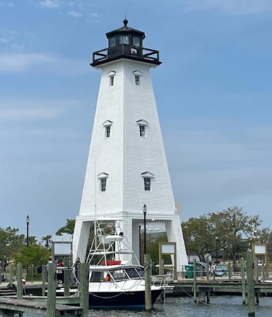
2011. Active (maintained by the city government); focal plane 14 m (46 ft); white flash every 4 s. 15 m (49 ft) square tower with lantern and gallery, supported by four legs. Lighthouse painted white, lantern and gallery black. Anirudh Girey's 2021 photo is at right, Eric Kennedy has a photo, Trabas has a photo, a 2012 photo is available, and Google has a street view and a satellite view. Designed as a replica of the Ship Island Lighthouse, the tower straddles the entrance to the city's new marina. Construction of the lighthouse was part of the city's redevelopment of the harbor area following its destruction by Hurricane Katrina. The light replaces a former skeletal tower. Located at the entrance to the Gulfport Marina. Owner/operator: City of Gulfport. Site manager: Gulfport Marina. Admiralty J3631.8; USCG 4-10020.
[Cat Island (2)]
1871 (station established 1831). Ruined square platform of the cottage screwpile lighthouse. No photo available but Google has a satellite view. Anderson has a page for this station. The original brick lighthouse, heavily damaged during the Civil War, was replaced by a cottage screwpile lighthouse in 1871. The lantern installed on the 1831 lighthouse in 1859 was transferred to the Tchefuncte River Lighthouse in Louisiana, where it survives. The 1871 lighthouse was deactivated in 1937. Sold in 1950 but left in place, it burned in 1961. There is no light in the area today. Located off the western tip of Cat Island. Accessible only by boat. Site open. ARLHS USA-145.

Hancock County (Bay St. Louis Area) Area Lighthouse
#Square Handkerchief Shoal (Merrill's Shell Bank, Pass Marianne) (3)
Date unknown (station established 1857). Replaced. This was a 17 ft (5 m) square skeletal tower mounted on the screwpile platform of the 1883 lighthouse. Ellis has a small photo (at the bottom of the page), Anderson has a page for this station, Lighthouse Digest has a Coast Guard photo and Huelse has a historic postcard view of the square cottage screwpile lighthouse built in 1883 after the 1857 cottage lighthouse burned to the waterline. Note the caption "Pass Marion" on the postcard; the light was long known locally as the Pass Marianne Light. The lighthouse was discontinued in 1945 and subsequently demolished; later the modern light was placed on the platform. In recent years the platform was removed and a post light (three green flashes, in a 2+1 pattern, every 6 s) replaced it; the light is not seen in Bing's satellite view. Located on the shoal off the entrance to Bay St. Louis, about 2.5 mi (4 km) southwest of Pass Christian. Accessible only by boat. Site open, tower closed. ARLHS USA-491. Active light: USCG 4-10330.

Gulfport Harbor Light, Gulfport, April 2021
Google Maps photo by Anirudh Girey

Information available on lost lighthouses:

Notable faux lighthouses:

Adjoining pages: North: Tennessee | East: Alabama | West: Louisiana

Return to the Lighthouse Directory index

Checked and revised September 18, 2023. Lighthouses: 18. Site copyright 2023 Russ Rowlett and the University of North Carolina at Chapel Hill.