Lighthouses of Canada: Southwestern Newfoundland

Newfoundland and Labrador -- including both the Island of Newfoundland and the mainland territory of Labrador -- is the easternmost province of Canada. During the 17th century Newfoundland attracted both French and British fishermen, but France ceded its settlements to Britain in 1713. Long governed as a British colony, Newfoundland became a self-governing dominion under the British Crown in 1907 but gave up its dominion status in 1934, during the Great Depression. Newfoundland then joined Canada as the tenth province in 1949 following a referendum the previous year. The name of the province was changed from Newfoundland to Newfoundland and Labrador in 2001.

The north coast of the Island of Newfoundland faces the Labrador Sea and the east and south coasts face the open North Atlantic Ocean. The west coast faces the Gulf of Saint Lawrence. The Cabot Strait separates Newfoundland from Nova Scotia to the southwest and the Strait of Belle Isle separates the Island of Newfoundland from Labrador on the northwest. This page includes lighthouses of the south coast and southwestern corner of the Island of Newfoundland. Other pages cover Northern Newfoundland and Southeastern Newfoundland.

Having a rocky and much-indented coast, Newfoundland established a large number of light stations, many of which remain active today. Until quite recently nearly all the lighthouses remained in the care of the Canadian Coast Guard. Now preservation organizations are beginning to appear in many communities.

Newfoundland is accessible by air and by Marine Atlantic car ferries from North Sydney, Nova Scotia. Ferry service is available year-round between North Sydney and Port aux Basques and in the summer between North Sydney and Argentia.

ARLHS numbers are from the ARLHS World List of Lights. CCG numbers are from the Newfoundland volume of the List of Lights, Buoys, and Fog Signals of Fisheries and Oceans Canada. Admiralty numbers are from Volume H of the Admiralty List of Lights & Fog Signals. U.S. NGA numbers are from Publication 110.

General Sources
Lighthouses of Newfoundland, Canada
Photos and notes by Kraig Anderson.
Lighthouses of Newfoundland
Photos by Karen Chappell and Joe Dawson.
Newfoundland Lighthouses
10 fine photos by Karl Josker.
Lighthouses of Newfoundland and Labrador
Photos available on Flickr.com.
Litehouseman's Newfoundland Lighthouses
A fine collection of 37 photos by "Litehouseman."
Photos by Roger Etcheberry
Newfoundland lighthouse photos posted on MarineTraffic.com
Lighthouses in Newfoundland and Labrador
Photos by various photographers available from Wikimedia.
Online List of Lights - Northern and Eastern Canada
Photos by various photographers posted by Alexander Trabas.
List of Lights, Buoys, and Fog Signals
Official Canadian light lists.
GPSNauticalCharts
Navigational chart information for Newfoundland.
Navionics Charts
Nautical chart for Newfoundland.

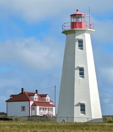
Cape Anguille Light
Cape Anguille Light, Codroy, circa 2007
Flickr Creative Commons photo
by Douglas Sprott

South Coast Lighthouses
Facing the open Atlantic, the wild south coast of Newfoundland is difficult to access. Ferries serve the scattered small communities, but only two roads reach the coast: highway 360 runs 205 km (125 mi) from Bishop's Falls to Harbour Breton, and highway 480 runs 150 km (90 mi) from Stephenville to Burgeo. Traditional lighthouses have been replaced by small modern beacons at most of the stations on this coast.
[Belleoram (Beach Point) (3?)]
Date unknown (station established 1873). Active; focal plane 10.5 m (34 ft); white flash every 3 s. 7 m (23 ft) square skeletal tower enclosed by a daymark colored with red and white horizontal bands. The light can be seen at lower left in an aerial photo by Dan Earles and Google has a satellite view. Lighthouse Digest has a photo of the original lighthouse, a square tower with lantern and gallery, and a Coast Guard photo of the second (1931) lighthouse, a small cast iron tower. Located on Beach Point, a spit protecting the harbor of Belleoram. Site open, tower closed. CCG N-117; Admiralty H0308; NGA 2288.
St. Jacques Island
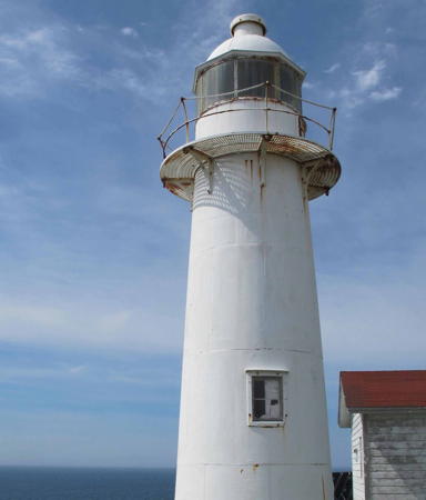
1908. Active; focal plane 40 m (131 ft); white light, 4 s on, 2 s off. 9 m (40 ft) round cast iron tower with lantern and gallery, painted white. Fog horn (3 s blast every 30 s). 1960 keeper's house and other station buildings. A DFO photo is at right and Google has a satellite view of the station. In 2013 a new group, the St. Jacques Island Heritage Corporation, began negotiating to take ownership of the light station, and this transfer occurred in 2017. The plan is to renovate the keeper's house for overnight stays. In 2019 a dock was built to facilitate restoration work. The lighthouse received Heritage designation in 2016. Located on a small island in Fortune Bay about 10 km (6 mi) south of Belleoram. Accessible only by boat. Site open, tower closed. Owner/site manager: St. Jacques Island Heritage Corporation . ARLHS CAN-669; CCG N-118; Admiralty H0304; NGA 2292.
[English Harbour West (2)]
Date unknown (1990s?) (station established 1921). Active; focal plane 14 m (45 ft); red flash every 4 s. 4 m (13 ft) square skeletal mast carrying a daymark with a red and a white horizontal band. Anderson's photos show the modern beacon but it is hard to see in Google's satellite view. This light was formerly on a 4.5 m (15 ft) square pyramidal wood tower. Located on a promontory on the east side of the entrance to English Harbour West, a town on the Connaigre Peninsula on the northwest side of Fortune Bay. Site open, tower closed. Owner/site manager: Canadian Coast Guard. CCG N-119; Admiralty H0302; NGA 2296.

St. Jacques Island Light, Fortune Bay
Dept. of Fisheries and Oceans photo
* Rocky Point (Harbour Breton) (2)
1881 (station established 1873). Active; focal plane 16 m (52 ft); white flash every 4 s. 7.5 m (25 ft) round cylindrical cast iron tower with lantern and gallery. Lighthouse painted with red and white horizontal bands. A 2010 photo is at right, Nathan Rybakov has a 2021 photo, Geoff Smith has a photo, Etcheberry has a photo, Lighthouse Digest has a Coast Guard photo, a historic photo is available, and Google has a distant satellite view of the lighthouse. The first lighthouse was destroyed by fire in 1881. In 2014 ownership was being transferred to the town, and in 2016 the lighthouse was granted Heritage status. Located on the south side of the entrance to Harbour Breton. Accessible by a short walk from the end of Hill Side Drive (highway 360). Site open, tower closed. Site manager: Town of Harbour Breton. ARLHS CAN-699; CCG N-124; Admiralty H0294; NGA 2316.
[Brunette Island (4?)]
Date unknown (station established 1865). Active; focal plane 124 m (407 ft); white flash every 4 s. 7 m (23 ft) square skeletal tower; the upper portion of the tower is covered by a daymark colored white with red bands at the top and bottom. No photo available but Bing has a satellite view showing the foundation ruins of the former light station. The original lighthouse, with a light tower centered on a keeper's house, was replaced by a round cast iron tower in 1931. Brunette Island is a substantial, uninhabited island in the entrance to Fortune Bay, about 25 km (15 mi) south of Harbour Breton. Located at the southeast corner of the island. Accessible only by boat (and a steep hike). Site open, tower closed. ARLHS CAN-797; CCG N-101; Admiralty H0290; NGA 2312.
Pass Island (3?)
Date unknown (station established 1879). Active; focal plane 86 m (282 ft); white flash every 10 s; there is also a red light (flash every 4 s) visible from the east and south. 9 m (30 ft) square pyramidal tower covered with white siding. Bing has an indistinct satellite view. Anderson has a Coast Guard photo of the original lighthouse, which was replaced by an octagonal tower in 1917. The buildings of the station, located on the south coast of the island, had fallen into ruin by 2008, but there is still an active fog signal (blast every 30 s) at the southwestern tip of the island. Located on the summit of Pass Island, on the east side of the entrance to Hermitage Bay. Accessible only by boat. Site status unknown. CCG N-129; Admiralty H0286; NGA 2320.
[Dawson Point (3) (Pushthrough)]
Date unknown (station established 1916). Active; focal plane 17 m (55 ft); white flash every 5 s. 4 m (14 ft) square cylindrical skeletal tower, partially enclosed by a daymark painted with red and white horizontal bands. Fog horn (blast every 20 s). 1-story keeper's house and several utility buildings. Etcheberry has a photo of the station and a view from the sea is available, but the tower is hard to find in Google's satellite view of the station. The original lighthouse was a wooden skeletal tower; this was replaced at some point by a square pyramidal wood tower. This station was staffed until recently but was scheduled for automation. Located on a headland on Hermitage Bay near Pushthrough. Accessibility by land and site status unknown. Site manager: Canadian Coast Guard. ARLHS CAN-838; CCG N-134; Admiralty H0276; NGA 2352.
Rocky Point Light
Rocky Point Light, Harbour Breton, June 2010
photo copyright Harbour Breton Coaster
permission requested
[Salmon Point (Taylor Island)]
Date unknown (1980s?). Active; focal plane 16 m (52 ft); white flash every 4 s. 6 m (20 ft) square skeletal tower carrying a large daymark with red and white horizontal bars. Keeper's house and other buildings. Bing has a distant satellite view of the area. Taylor Island is a small island on the north side of the entrance to Hermitage Bay. Located on the southeastern tip of the island. Accessible only by boat. Site status unknown. Site manager: Canadian Coast Guard. CCG N-135; Admiralty H0275; NGA 2356.
François Bay (West Point) (2)
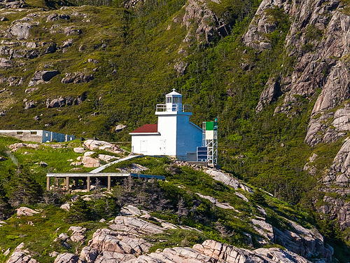
1966 (fog signal station established 1929, light station 1958). Inactive since 2015. Approx. 14 m (46 ft) square cylindrical concrete tower, formerly attached to a 2-story keeper's quarters. Lighthouse painted white. The active light (focal plane 46 m (151 ft); green flash every 5 s) is on a square skeletal tower in front of the lighthouse. Etcheberry has a 2013 closeup photo, Adam Woodworth has a 2019 view from the sea, Lighthouse Digest has a Coast Guard photo and Google has a satellite view of the station. In 2015 the Coast Guard announced it would demolish the dilapidated keeper's house, but the historic light tower would be preserved. Located on a promontory on the west side of the entrance to François Bay. Accessible only by boat, but there's a view from arriving ferries. Site status unknown. Site manager: Canadian Coast Guard. ARLHS CAN-701. Active light: CCG N-137; Admiralty H0270; NGA 2360.

Ramea and Burgeo Area Lighthouses
* Northwest Head (Ramea)
1902. Active; focal plane 38 m (125 ft); white flash every 3 s. 9 m (30 ft) cylindrical cast iron tower with lantern and a small gallery, painted with a red and white spiral (candy stripe) pattern. Fog horn (blast every 30 s). Rene Jeddore's street view is at right, Anthony Rose has a good 2006 photo of the station, Lighthouse Digest has a 1999 Coast Guard photo, Will Armstrong has a street view, and Google has a satellite view of the station. A 2019 photo shows the lighthouse freshly repainted. Located on an island about 6 km (4 mi) off the coast near the western entrance to Hermitage Bay. Accessible by road or hiking trail from the town of Ramea, which is reached by car ferry from Burgeo. Site open, tower closed. Site manager: Canadian Coast Guard. . ARLHS CAN-695; CCG N-141; Admiralty H0264; NGA 2380.
Boar Island (Burgeo) (3?)
Date unknown (station established 1874). Active; focal plane 63 m (207 ft); white flash every 5 s. 10 m (33 ft) square cylindrical skeletal tower with lantern and gallery. Google has a satellite view of the station. Lighthouse Digest has a photo of the original lighthouse, a wood tower attached to a 1-1/2 story keeper's house, and Anderson has a photo of the second, a square pyramidal wood tower. This lighthouse was deactivated in 1946 and demolished but we don't know if the present light dates from that time. Boar Island is about 2 km (1.25 mi) east of Burgeo and this light serves as the landfall light for the town. Located at the east end of the island. Accessible only by boat, but there are good views from the ferries between Burgeo and Ramea. Site open, tower closed. ARLHS CAN-676; CCG N-144; Admiralty H0260; NGA 2392.

Northwest Head Light, Ramea, August 2017
Google Maps street view by Rene Jeddore
[Ireland Island (2)]
Date unknown (station established 1886). Active; focal plane 18.5 m (61 ft); white flash every 6 s. 6 m (20 ft) square skeletal mast carrying a daymark colored with red and white horizontal bands. No photo available and the slender tower is not seen in Bing's satellite view. The station was burned, apparently in the early 1990s. Located on a small island off the entrance to La Poile Bay. Accessible only by boat. Site open, tower closed. ARLHS CAN-840; CCG N-146; Admiralty H0252; NGA 2404.

Channel-Port-aux-Basques Area Lighthouses
Channel-Port-aux-Basques is a town of about 4000 at the southwestern tip of Newfoundland. The terminal for ferries from North Sydney, Nova Scotia, it is the entry point for many visitors to the island.
**** Rose Blanche (4)
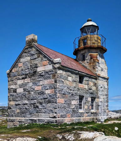
1996 (reconstructed 1873 lighthouse). Reactivated (inactive ca. 1941-2002; now privately maintained); focal plane 29 m (95 ft); red flash every 10 s. 12 m (40 ft) octagonal granite light tower with lantern and gallery, mounted at one end of a 1-1/2 story granite keeper's house; 6th order Fresnel lens. Fog horn (blast every 60 s) nearby. A photo is at right, Ashley Coombs has a good closeup, Eric Bernier has a 2022 photo, Greg Hickman has a photo, Anderson's page has photos, a 2007 closeup is available, Wikimedia has distant views, Google has a street view, and Bing has a satellite view. The only surviving lighthouse of its type in Canada. The light was moved to a wood skeletal tower in the early 1940s, then to a steel skeletal tower in the early 1960s, and finally deactivated sometime in the 1980s. The historic keeper's house collapsed during a storm in October 1957 leaving the light tower standing; Anderson has a 1990 Coast Guard photo. In 1988 the Southwest Coast Development Association identified the ruined station as a site for tourism development. A plan was in place by 1992 and after nearly $900,000 in grants were secured and local workers were trained in stonemasonry the light was rebuilt in 1996-97. The lighthouse was relit on 3 August 2002. The 150th anniversary of the light station was celebrated in July 2023. Located beyond the end of NF 470 about 45 km (28 mi) east of Channel-Port aux Basques. Accessible by a short walk from the end of the road. Site open, lighthouse and tower open daily early June to late September (admission fee). Operator/site manager: Rose Blanche Lighthouse, Inc. . ARLHS CAN-668; CCG N-150.19; Admiralty H0242.5; NGA 2418.
[Cain's Island (4?)]
Date unknown (fog signal station established 1904, light added in 1907). Active fog signal station (one 4 s blast every 60 s); in addition a red light (flash every 6 s) is shown from a small mast. Anderson has Coast Guard photos of the first, second, and third (1990) lighthouses, and Bing has a satellite view of the station. Located on an island about 500 m (0.3 mi) west of the Rose Blanche lighthouse (previous entry). Accessible only by boat. Site status unknown. CCG N-151.07; Admiralty H0244; NGA 2420.
Colombier Islands (2)
Date unknown (light established 1971; established as a fog signal station in 1929). Active; focal plane 18.5 m (61 ft); white flash every 5 s. 11 m (37 ft) square cylindrical aluminum skeletal tower. Fog horn (3 s blast every 30 s). The first light was atop the fog signal building. A utility building remains from the original fog signal station. Bing has an indistinct satellite view of the station and Google has an indistinct street view from Burnt Island (the Burnt Island Range Front Light is in the foreground). Located on an island off Burnt Island, midway between Rose Blanche and Channel-Port aux Basques. Accessible only by boat. Site manager: Canadian Coast Guard. ARLHS CAN-837; CCG N-156; Admiralty H0238; NGA 2436.
Rose Blanche Light
Rose Blanche Light, Rose Blanche, October 2012
Flickr Creative Commons photo
by mrbanjo1138
* [Burnt Island Range Front (2?)]
Date unknown (station established 1915). Active; focal plane 16 m (52 ft); continuous red light. 4.5 m (15 ft) square skeletal tower carrying a trapezoidal daymark colored white with a red vertical stripe. Anderson has a photo of the two range lights, Google has a street view, and Bing has a satellite view. The original lighthouse was a square wood tower. Located on the south side of West Street in Burnt Island. Site open, tower closed. CCG N-154; Admiralty H0234; NGA 2428.
* [Burnt Island Range Rear (2?)]
Date unknown (station established 1915). Active; focal plane 20.5 m (68 ft); continuous red light. 4.5 m (15 ft) square skeletal tower carrying a trapezoidal daymark colored white with a red vertical stripe. Anderson has a photo of the two range lights, Google has a street view, and Bing has a satellite view. The original lighthouse was a square wood tower. Located on the south side of West Street in Burnt Island. Site open, tower closed. CCG N-155; Admiralty H0234.1; NGA 2432.
Channel Head (Channel-Port-aux-Basques) (2)
1895 (station established 1874). Active; focal plane 29 m (95 ft); white flash every 10 s. 11 m (36 ft) cylindrical cast iron tower with lantern and gallery, painted white. Fog horn (4 s blast every 60 s). A photo is at right, Robert Hall has a fine sunrise photo, Garry Spencer has a photo, Mel Mashman has a more distant view, Wikimedia has two views, Trabas has Michael Boucher's distant view, Google has a distant street view and a distant satellite view. The Coast Guard restored the lighthouse in a major 2015 project but in April 2016 the Coast Guard announced that the wharf at the station had become unsafe and would be removed; the only access to the lighthouse would then be by helicopter. After protests by the quickly-organized Channel Head Heritage Lighthouse Society the government relented. In the spring of 2017 a new wharf was built along with a walkway from the wharf to the light station. Located on an island on the west side of the entrance to Channel-Port aux Basques harbor. Accessible only by boat, but visible from the mainland at the end of Lawrence Lane and from the Gulf of St. Lawrence ferry steamers as they enter or leave the harbor. Port-aux-Basques Marine Excursions offers picnic tours to the lighthouse. Site open, tower closed. Site manager: Canadian Coast Guard. . ARLHS CAN-654; CCG N-160; Admiralty H0222; NGA 2468.

Channel Head Light, Channel-Port-aux-Basques
TripAdvisor photo by Port aux Basques Marine Excursions Inc.
** Cape Ray (3)
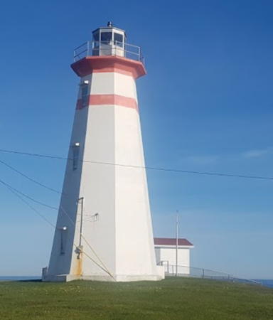
1959 (station established 1871). Active; focal plane 37 m (120 ft); white light, 1 s on, 14 s off. 15 m (48 ft) octagonal concrete tower with lantern and gallery, painted white with a narrow red horizontal band near the top; the lantern is gray. Fog horn (4 s blast every 60 s). The keeper's house is now operated as a museum and gift shop. Lyle Wilkinson's photo is at right, Stephen Genereaux has a 2022 view of the lighthouse, Cathy Hounsell has a 2020 photo, Gary Barfitt has a good August 2006 closeup, Todd Boland has a 2008 closeup, Lighthouse Digest has a Coast Guard photo, Trabas has Rainer Arndt's closeup, and Google has a street view and a satellite view. Earlier lighthouses were destroyed by fire in 1885 and 1959, respectively. The lighthouse was closed to climbing in 2008 due to a lack of volunteer guides; it remains closed. The lighthouse was repainted and refurbished in 2013. Located at the southwestern tip of Newfoundland off Highway 1 about 15 km (10 mi) west of Channel-Port aux Basques. Site open; museum open daily in July and August, tower closed. Site manager: South West Coast Development Association. . ARLHS CAN-645; CCG N-173; Admiralty H0220; NGA 2492.
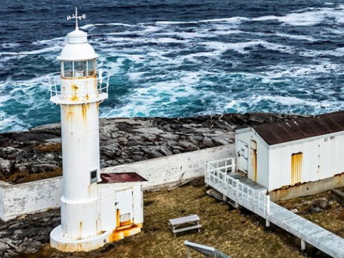
* Cape Anguille (2)
1960 (station established 1908). Active; focal plane 25 m (82 ft); white flash every 5 s. 18 m (59 ft) octagonal concrete tower with lantern and gallery, painted white; lantern is red. Fog horn (3 s blast every 30 s). Douglas Sprott's photo is at the top of this page, Jeremy Kurtin has a 2021 photo, Todd Boland has a good 2008 closeup, a fine 2005 photo is available, Lighthouse Digest has a Coast Guard photo, and Google has a satellite view of the station. This lighthouse stands on the westernmost point of Newfoundland. In 2002 Lighthouse Digest reported that the destaffed keeper's houses were to be converted to a bed and breakfast, restaurant and craft shop, and for this purpose the station was conveyed to the Southwest Coast Development Association in August 2002. In 2004, the duplex principal keeper's house became the Cape Anguille Lighthouse Inn. The original lighthouse here, built in 1908, was a buttressed ferroconcrete tower. Located at the end of NF 407, northwest of Cape Ray near Codroy. Site open, tower closed. Site manager: Southwest Coast Development Association. . ARLHS CAN-651; CCG N-175; Admiralty H0218; NGA 2504.
Cape Ray Light
Cape Ray Light, Channel-Port-aux-Basques, September 2008
photo
copyright Lyle Wilkinson; used by permission

Stephenville and Corner Brook Area Lighthouses
Located roughly 225 km (140 mi) north of Channel-Port-aux-Basques, Stephenville and Corner Brook are the largest towns of western Newfoundland. The coast in this area faces west on the Gulf of Saint Lawrence. It is distinguished by the fishhook-shaped Port au Port Peninsula, which projects 60 km (37 mi) due west into the Gulf and then 50 km (30 mi) northeast sheltering Port au Port Bay.
Harbour Point (Sandy Point)
1883. Active; focal plane 11 m (35 ft); white light, 1 s on, 5 s off. 9 m (31 ft) round cylindrical cast iron tower with lantern and gallery, painted with red and white horizontal bands. Google has an indistinct satellite view. Although Harbour Point is the official name, the lighthouse is usually called the Sandy Point Light. Many photos showed the lighthouse to be in very poor condition, but in 2010 the Coast Guard refurbished and repainted the tower. Karl Jarry has the 2022 sunset photo seen at right, Lighthouse Digest has an older photo by Jonathan Walsh. Located on Sandy Island at the entrance to St. George's Harbour, about 16 km (10 mi) southeast of Stephenville. Accessible only by boat (or a very long hike with some wading); tours of the historic island are available. Site open, tower closed. Site manager: Canadian Coast Guard. ARLHS CAN-690; CCG N-178; Admiralty H0208; NGA 2516.
Port Harmon Range Front
Date unknown. Active; focal plane 43 m (141 ft); continuous green light. 27 m (89 ft) square pyramidal skeletal tower carrying a slatted daymark colored red with a white vertical stripe. Google has a street view and a satellite view. The range guides vessels on a dredged channel into Port Harmon, the commercial port of Stephenville. Located on a hillside above the port. Site status unknown. CCG N-179.3; Admiralty H0206; NGA 2540.
Port Harmon Range Rear
Date unknown. Active; focal plane 56 m (184 ft); continuous green light. 27 m (89 ft) square pyramidal skeletal tower carrying a slatted daymark colored red with a white vertical stripe. No photo available but Google has a satellite view and a distant street view. Located 244 m (800 ft) north northwest of the front light. Site status unknown. CCG N-179.4; Admiralty H0206.1; NGA 2544.

Harbour Point Light, St. George's Harbour, December 2022
Google Maps photo by Karl Jarry
[Long Point (Port au Port) (2?)]
Date unknown (station established 1909). Active; focal plane 15 m (49 ft); white flash every 6 s. 11 m (36 ft) square skeletal tower carrying a red slatwork daymark. No photo available but Google has a satellite view. Anderson has a Coast Guard photo of the original lighthouse, a square wood tower with lantern and gallery. Located on the beach near the end of the Port au Port Peninsula. Site status unknown. Owner/site manager: Canadian Coast Guard. CCG N-185; Admiralty H0196; NGA 2568.
* Broad Cove Point Range Front (relocated to Fox Island River)
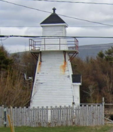
1955. Inactive since 2005. 9 m (31 ft) square pyramidal wood tower with lantern and gallery, painted white; gallery rail is red. Formerly located on a bluff at Broad Cove Point marking the east side of the entrance to Port au Port Bay. The lighthouse was salvaged by Yve LeRoy, who moved it by helicopter to his back yard in Fox Island River, about 10 km (6 mi) south of the original location. LeRoy has restored the lighthouse, as seen in his photo at right. Google has a street view and Bing has a satellite view. Located on the south side of Fox Island River. Site and tower closed (private property), but the light is visible from the road and the owner will sometimes give tours to polite visitors. Owner/site manager: private. ARLHS CAN-833; ex-CCG N-186; ex-Admiralty H0199; ex-NGA 2584.
#Broad Cove Point Range Rear
1955. Inactive since 2005 and demolished then or soon thereafter. This was a 15 m (50 ft) square pyramidal steel skeletal tower with lantern and gallery; upper 1/3 enclosed by wood siding. This style of lighthouse is fairly common in mainland Canada but this tower was the only example in Newfoundland and Labrador. Yve LeRoy used materials from this lighthouse in the restoration of the front light (previous entry). Formerly located about 340 m (375 yd) southeast of the front range tower at Broad Cove Point, about 10 km (6 mi) north of Fox Island River. ARLHS CAN-834; ex-CCG N-187; ex-Admiralty H0199.1; ex-NGA 2588.
[Little Port Head (2?)]
Date unknown (station established 1917). Active; focal plane 67.5 m (221 ft); white flash every 6 s. 4.5 m (15 ft) square skeletal tower carrying a daymark colored red with a white horizontal band. Chris Soper has a photo, Laura Hamilton has a photo, and Google has a satellite view. Located on a headland near Lark Harbour, about 5 km (3 mi) south of the entrance to the Bay of Islands. Accessible by a hiking trail. Site open, tower closed. CCG N-196; Admiralty H0194; NGA 2600.
#South Head (2)
1950s (station established 1925). Demolished in 2010. This was a 7 m (24 ft) octagonal concrete tower with lantern and gallery. Lighthouse Digest has a Coast Guard photo. The lighthouse was replaced by round fiberglass post (focal plane 35 m (116 ft); white flash every 4 s). Anderson has a photo of the newly installed light and Google has a distant satellite view. Located at the southern entrance to the Bay of Islands, about 6 km (3.5 mi) north of Lark Harbour. Site open but quite difficult to reach by land. Site manager: Canadian Coast Guard. ARLHS CAN-751. Active light: CCG N-192; Admiralty H0192; NGA 2604.

Broad Cove Front Range Light, Fox Island River
photo copyright Yve LeRoy
[Frenchman's Head (3)]
Date unknown (station established 1901). Active; focal plane 82.5 m (271 ft); white flash every 6 s. 10 m (33 ft) square cylindrical skeletal tower carrying a daymark colored white with red bands at the top and bottom. Trabas has Brigitte Adam's photo, Sheika Gallant-Halloran has a view from the sea, and Google has a satellite view. The original lighthouse was a square wood tower originally attached to a keeper's house; it was replaced by a skeletal tower in the 1950s. Located atop a steep bluff on the west side of the entrance to Humber Arm, the fjord leading to Corner Brook. Site status unknown. ARLHS CAN-839; CCG N-198; Admiralty H0186; NGA 2628.

Information available on lost lighthouses:

Adjoining pages: North: Northern Newfoundland | East: Southeastern Newfoundland | South: St. Pierre and Miquelon

Return to the Lighthouse Directory index

Posted December 2002. Checked and revised July 10, 2023. Lighthouses: 20. Site copyright 2023 Russ Rowlett and the University of North Carolina at Chapel Hill.