Lighthouses of Norway: Telemark (Skien Area)

The Kingdom of Norway (Norge in Norwegian) is one of the world's most maritime nations. The country is long and narrow, with drowned valleys called fjords that bring the sea far inland in most regions. The mainland coast is estimated to be 2650 km (1650 mi) long, and when all the islands and minor indentations are counted the total coastline approaches an astonishing 60,000 km (37,500 mi), long enough the go around the world one and a half times. With such a lengthy and rocky shore it's not surprising that Norway has a large number of lighthouses.

Norway is divided into counties (fylker) and the counties are divided into townships (kommuner). In 2020 mergers decreed by the national government reduced the number of counties from 19 to 11. This page lists lighthouses of the former (and future) county of Telemark, which faces the west side of the Oslofjord and the north side of the Skagerrak on Norway's south coast. Skien is the largest town in this region and the seat of the county government. In 2020 the counties of Vestfold and Telemark were merged to form the county of Vestfold og Telemark. This merger was very unpopular and the original counties will be restored effective 1 January 2024.

In Norwegian a lighthouse is a fyrtårn (fire tower) or simply a fyr; a fyrlykt is a beacon and a lyktehus is a lantern. Øy is an island, holmen is an islet, skjær is a skerry (a tiny island or rocky reef), sund is a strait (often between an island and the mainland), bukt is a bay, nes is a headland, and havn is a harbor.

Aids to navigation in Norway are maintained by the Kystverket (Coast Directorate), an agency of the Ministry of Transport and Communications.

ARLHS numbers are from the ARLHS World List of Lights. NF numbers are from the Norsk Fyrliste. Admiralty numbers are from volume B of the Admiralty List of Lights & Fog Signals. U.S. NGA List numbers are from Publication 115, but NGA has dropped nearly all of the lights of southern Norwegian fjords in this area.

General Sources
Online List of Lights - Norway North Sea
Photos by various photographers posted by Alexander Trabas; many of these photos were taken by Michael Boucher, Ronald Wöhrn, or Capt. Peter Mosselberger ("Capt. Peter").
Norwegian Lighthouse Association
News and photos from the Association.
Lighthouses in Norway
Photos by various photographers available from Wikimedia.
World of Lighthouses - Norway
Photos by various photographers available from Lightphotos.net.
Norsk Fyrliste
Current edition of the Norwegian light list.
Norwegische Leuchttürme auf historischen Postkarten
Historic postcard images posted by Klaus Huelse.
Liste over Norske Fyr
From Norwegian Wikipedia, a handy list of Norwegian light stations with their dates of establishment.
GPSNauticalCharts
Navigational chart information for the Skaggerak.
Navionics Charts
Navigational chart for the Skaggerak.


Old and new Jomfruland Lights, Kragerø, August 2013
Wikimedia Creative Commons photo by Dagfinn Rasmussen
Porsgrunn Lighthouses
Røodden
Date unknown. Active; focal plane 9.5 m (31 ft); white, red or green light depending on direction, occulting once every 6 s. 10.5 m (34 ft) concrete post with lantern and gallery. Tower painted white with one green horizontal band, lantern white with a red roof. Trabas has Capt. Peter's photo and Google has a satellite view. Located on the southeastern tip of Sandøy, about 2.5 km (1.5 mi) northeast of Ekstrand. Accessible only by boat. Site open, tower closed. NF-045700; Admiralty B2596.4; ex-NGA 0904.
Midtfjordskjær
Date unknown. Active; focal plane 10.5 m (34 ft); white, red or green light depending on direction, occulting three times every 10 s. 13 m (43 ft) concrete post with lantern and gallery. Tower painted white with one red horizontal band, lantern white with a red roof. Trabas has Capt. Peter's photo and Google has a satellite view. Located in the Frierfjord about 1 km (0.6 mi) west of the E-18 bridge at Brevik. Accessible only by boat. Site open, tower closed. NF-047600; Admiralty B2642; ex-NGA 0944.
Saltbuodden
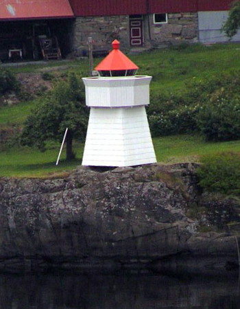
Date unknown. Active; focal plane 9 m (30 ft); white, red or green light depending on direction, occulting once every 6 s. 6 m (20 ft) square skeletal tower with lantern and gallery. Tower covered with white siding; lantern painted white with a red roof. Trabas has Capt. Peter's photo (also seen at right) and Google has a satellite view. Located on the east side of the Frierfjord about 5 km (3 mi) above Brevik. Site status unknown. NF-047700; Admiralty B2644; ex-NGA 0948.

Skien Lighthouse
* Torsberg
Date unknown. Active; focal plane 9 m (30 ft); white, red or green light depending on direction, occulting once every 6 s. 6.5 m (21 ft) square skeletal tower with lantern and gallery. Tower covered with white siding; lantern painted white with a red roof. Trabas has Capt. Peter's photo and Google has a street view and a satellite view. Located beside the Svanvikvegen (highway 356) at the west side of the entrance to the Porsgrunn River opposite Porsgrunn. Site open, tower closed. NF-048000; Admiralty B2646; ex-NGA 0956.
Saltbuodden Fyr
Saltbuodden Fyr, Porsgrunn
photo copyright Capt. Peter Mosselberger; used by permission

Bamble Lighthouses
Steinholmen
Date unknown. Active; focal plane about 8 m (26 ft); red light, 1 s on, 1 s off. 9 m (30 ft) concrete post with lantern and gallery. Tower painted white with a red horizontal band, lantern white with a red roof. Trabas has Capt. Peter's photo and Google has a satellite view and a street view from the Grenland Bridge. Located on the south side of the Brevikfjord just east of the Grenlandsbrua (bridge). Accessible only by boat. Site open, tower closed. NF-046900; Admiralty B2639.5.
Krabberød
2010. Active; focal plane about 7.5 m (25 ft); continuous yellow light. 8.5 m (26 ft) concrete post with lantern and gallery. Tower painted white with two red horizontal bands, lantern white with a red roof. Trabas has Capt. Peter's photo and Google has a street view and a satellite view. Located on the south side of the Brevikfjord midway between the Grenlandsbrua and the Breviksbrua (bridges). Accessible only by boat. Site open, tower closed. NF-046800; Admiralty B2636.8; ex-NGA 0937.
Mølletangen
2010. Active; focal plane about 9 m (30 ft); red light, 1 s on, 1 s off. 10 m (33 ft) concrete post with lantern and gallery. Tower painted white with a red horizontal band, lantern white with a red roof. Trabas has Capt. Peter's photo, another photo is available, and Google has a street view and a satellite view. Located on the south side of the Brevikfjord just east of the Breviksbrua (bridge). Accessible only by boat. Site open, tower closed. NF-046500; Admiralty B2635.8.
* Gjermesholmen (Croftholmen)
Date unknown. Active; focal plane 5 m (17 ft); red or green light, occulting three times every 10 s. 6 m (20 ft) lantern and gallery on a platform supported by four straight piles. Lantern painted white with a red roof, piles painted black. Trabas has Capt. Peter's photo and Google has a satellite view. Gjermesholmen (or Croftholmen) is an island on the south side of the Brevikfjord at Stathelle. Located on the northern point of the island, which is accessible by a short bridge from the mainland. Site open, tower closed. NF-046400; Admiralty B2632; ex-NGA 0928.
* Figgeskjær
1892. Active; focal plane 9 m (30 ft); white, red or green light depending on direction, occulting twice every 8 s. 9 m (30 ft) square skeletal tower with lantern and gallery. Lighthouse painted white, lantern dome red. Approx. 6 m (20 ft) square "Swiss-chalet" wood fog bell tower, painted white, with open bell enclosure and bell. Danckert Monrad-Krohn's photo is at right, Trabas has Capt. Peter's photo and Google has a sea view and a satellite view. The fog bell tower, built in 1911, has been inactive since 1989. The bell and striking mechanism are intact, and the station is perserved as a historic monument. Located on a point of land on the west side of the Langesundfjorden about 1 km (0.6 mi) north of Langesund. Site open, tower closed. . ARLHS NOR-078; NF-046000; Admiralty B2616; ex-NGA 0912.
 

Figgeskjær Light and Fog Signal, Bamble
Culture Ministry Creative Commons photo by Danckert Monrad-Krohn
* Langesund Range Rear
Date unknown. Inactive. 9 m (30 ft) lantern mounted on a concrete column at the end of a jetty. Lantern painted white with a red roof. Google has a distant sea view and an indistinct satellite view. The light (focal plane 11 m (36 ft); red light occulting once every 6 s) has been moved atop a mast seen in a Google street view. This range guides vessels southbound into Langesund; the front light is in a small lantern on a pier 425 m (1/4 mi) to the north. Located at the end of a short pier at the northern end of Langesund harbor. Site open, tower closed. Active light: NF-046300; Admiralty B2620.1; ex-NGA 0920.
* Langøytangen (2)
1876 (station established 1839). Active; focal plane 17 m (56 ft); white, red or green light depending on direction, occulting once every 6 s. Approx. 12 m (39 ft) square cylindrical masonry tower with lantern and gallery, attached to one end of a 1-story keeper's house. Lighthouse painted white, lantern and gallery red. Fog horn (two blasts every 60 s). Additional 1-1/2-story keeper's house and other buildings, some available for overnight accommodations. Marcin Klonowicz has the 2020 photo seen at right, the Lighthouse Association has a page for the light station, Trabas has posted a photo by Wöhrn, Wikimedia has several photos, Sebastian Bergmann has a photo, Norwegian Wikipedia has a page for the lighthouse, and Google has a satellite view. Located at the southern tip of Langøy (Long Island), a 1.5 km (1 mi) long island that forms a natural breakwater for the harbor of Langesund. Site open, tower closed. Site manager: Langesundsfjorden Kystlag. . ARLHS NOR-152; NF-044200; Admiralty B2598; NGA 0852.
Mejulen
Date unknown. Active; focal plane 6 m (20 ft); flash every 5 s, white, red or green depending on direction. 7 m (23 ft) lantern mounted on a platform supported by piles. Lantern painted white with a red roof, piles painted black. Wikimedia has a closeup photo and Google has a satellite view. Located on the northwest side of a small island about 6 km (3.5 mi) southwest of Langesund. Accessible only by boat. Site open, tower closed. NF-050600; Admiralty B2674; ex-NGA 0980.

Kragerø Lighthouses
**** Jomfruland (Range Rear) (1)
1839. Inactive since 1938. 22 m (72 ft) round brick tower with gallery, painted white; lantern removed. Lantern removed; weather instruments and a communications antenna are mounted on the capped tower. Dagfinn Rasmussen's photo is at the top of this page, Rikard Stokke has a 2022 photo, Roger Lovseth has a closeup photo, and Google has a closeup street view and a satellite view. Huelse has a historic postcard view of the lighthouse with its lantern and a wooden fog signal tower (since removed). Jomfruland is a low island, a glacial moraine, lying parallel to the coast of the Skagerrak off the mouth of the Kragerøfjord. The island is popular as a summer resort and as a birding destination. The old tower now houses a lighthouse museum, and the adjoining keeper's house is an art gallery. Another keeper's house is a vacation house for Kystverket employees. During the summer, open-air concerts are held on the grounds of the station. Located near the center of the island; transportation is available from Kragerø. Site open, tower open during the summer. ARLHS NOR-313.

Langøytangen Fyr, Bamble, September 2020
Google Maps photo by Marcin Klonowicz
 
* Jomfruland (Range Rear) (2)
1938 (station established 1839). Active; focal plane 48 m (157 ft); continuous white light with a brighter flash every 15 s. 31 m round cast iron tower with lantern and gallery. 2nd order Fresnel lens in use. Lighthouse painted white, lantern dome red. Several keeper's houses, greenhouse, and other station buildings. Dagfinn Rasmussen's photo is at the top of this page, Trabas has a closeup photo by Wöhrn, Karen Tjøstelsdatter has a 2008 photo, Rikard Stokke has a 2022 photo, Huelse has a historic postcard view, and Google has a closeup street view and a satellite view. The range guides ships approaching the Kragerøfjord and Kragerø; the continuous light also aids ships sailing toward Oslo. The newer tower was built because trees were obstructing the light of the old one. Located near the center of the island; transportation is available from Kragerø. Site open, tower closed. . ARLHS NOR-025; NF-052500; Admiralty B2698; NGA 1032.
* Djupodden (Jomfruland Range Front) (1)(?)
1904. Inactive since about 2015. 6 m (20 ft) square skeletal tower with wood siding, lantern and gallery. Lighthouse painted white, lantern roof red. No photo available. Google's satellite view shows that the light (focal plane 14 m (46 ft); white light, 2 s on, 2 s off) has been moved to a mast. We need information on the current status of the original lighthouse. Located on the coast of Jomfruland about 1150 m (3/4 mi) southwest of the lighthouse. Site open, tower closed. NF-052600. Active light: Admiralty B2696; NGA 1028.
#Knubbehausen (1)
Date unknown. Active; focal plane 12 m (39 ft); flash every 5 s, white, red or green depending on direction. This was a 14 m (46 ft) concrete post with lantern and gallery, mounted on a concrete platform supported by three piles. Lighthouse painted white with one red horizontal band; lantern roof also painted red. The light was replaced by a skeletal mast after being destroyed by collision with the ship Hagland Saga in April 2011. A distant view of the new light is available and Google has a distant satellite view. Located in the Skagerrak about 1.5 km (1 mi) southeast of the entrance to the Kragerøfjorden. Accessible only by boat. Site open, tower closed. Active light: NF-053000; Admiralty B2716; NGA 1034.
Stavseng (Range Rear)
1874. Active; focal plane 26 m (85 ft); white, red or green light depending on direction, occulting twice every 8 s. 17 m (56 ft) square cylindrical wood tower with lantern and gallery, rising from the front of a 1-1/2 story wood keeper's house. Lighthouse painted white, lantern roof is red. Danckert Monrad-Krohn's photo is at right, Trabas has a photo by Wöhrn, Per Arvid Åsen has a 2018 photo, another photo and a third photo are available, and Google has a satellite view. This was formerly a rear range light with the Strømtangen lighthouse (see below) as the front light. Located on the south coast of Tåtøy, an island in the mouth of Kragerøfjord. The island is accessible by ferry from Kragerø. Site status unknown. ARLHS NOR-226; NF-053200; Admiralty B2708.1; ex-NGA 1040.
Stavseng Light
Stavseng Light, Kragerø
Wikimedia Creative Commons photo by Danckert Monrad-Krohn
Buttebåen
1907. Active; focal plane 4 m (13 ft); white, red or green light depending on direction, occulting twice every 8 s. 5 m (17 ft) round fiberglass lantern mounted on steel piles. Lantern colored white with a red roof, piles painted black. Trabas has a photo by Wöhrn and Google has a distant satellite view. Located in the Kragerøfjorden off the western tip of the island of Slatøy. Accessible only by boat, although there is probably a good view from the island. Site open, tower closed. Admiralty B2710; NF-053300; ex-NGA 1044.
Galeiodden (Kragerø Havn) (2)
Date unknown (station established 1879). Active; focal plane 4 m (13 ft); white, red or green light depending on direction, occulting once every 6 s. 5 m (17 ft) post with lantern and gallery. Lantern painted white with a red roof. Trabas has Wöhrn's photo, the light is in the upper left corner of Per-Erik Schulze's 2022 photo, and Bing has an indistinct satellite view. Located on the eastern tip of the rocky islet of Galeiodden, in Kragerø harbor. The island is accessible by a bridge. Site open, tower closed. NF-053800; Admiralty B2714; ex-NGA 1052.
* Strømtangen (Range Front)
1874. Active; focal plane 8 m (26 ft); red light, 1 s on, 1 s off. 9 m (30 ft) 1-1/2 story wood keeper's house with lantern on the front of the building. Lighthouse painted white, lantern red. A closeup photo is at right, Trabas has an excellent photo by Wöhrn, Tore Heggelund has a photo, Lars Verket has a closeup photo, Morgan Sørensen has a 2021 photo, Huelse has a historic postcard view, and Bing has a satellite view. This was formerly a front range light with the Stavseng lighthouse (see above) as the rear light. Note: there is another Strømtangen lighthouse near Fredrikstad (see the Fredrikstad Area page). The lighthouse was leased by a diving club for several years, then used by the Kystverket as a holiday home for employees. In 2022 it was leased by the Kragerø Coastal Association and will be made available for holiday rental. Located on a point of land at the west entrance to the Kragerøfjord. Site open, tower closed. Site manager: Kragerø Kystlag. ARLHS NOR-291; NF-053100; Admiralty B2708; ex-NGA 1036.

Strømtangen Fyr, Kragerø, April 2015
Google Maps photo by Mariusz K-S

Lake Bandak Lighthouse
Lake Bandak, in northwestern Telemark, is connected to the sea by the Telemark Canal. The canal connects several lakes with 18 locks while extending 105 km (65 mi) from Skien to Dalen. Lake Bandak, the highest and westernmost of the lakes joined by the canal, has an elevation of about 72 m (236 ft).

[Høynesodden (Dalen)]
Date unknown. Inactive. 3 m (10 ft) octagonal lantern, painted white with a red roof. A small photo is available (near the bottom of the page) and Google has a street view, but the tiny light is not seen in Google's satellite view. This is said to be the highest lighthouse in Norway (it has a focal plane of about 80 m (262 ft) above sea level, 8 m (26 ft) above the lake surface). Located on a promontory a short distance east of Dalen. Accessible only by boat. Site status unknown.

Information available on lost lighthouses:

Notable faux lighthouses:

Adjoining pages: East: West Oslofjord | West: Aust-Agder (Arendal Area)

Return to the Lighthouse Directory index | Ratings key

Posted April 10, 2006. Checked and revised March 16, 2023. Lighthouses: 20. Site copyright 2023 Russ Rowlett and the University of North Carolina at Chapel Hill.