Lighthouses of Australia: Southern Queensland

The independent Commonwealth of Australia occupies the entire Australian continent, the island of Tasmania, and numerous smaller islands. British exploration and settling of the continent began late in the 1700s, with the first colony established in the Sydney area in 1788. By the 1850s there were six British colonies, including New South Wales and Queensland in the east, Victoria and South Australia in the south, Western Australia in the west, and Tasmania off the south coast. The Commonwealth was formed on New Years Day 1901 as a federation of the six colonies.

Australia is both the smallest continent and the sixth-largest country in the world, with a population of about 26 million. It continues to be a federation of the six original states, plus the federally administered Northern Territory, Australian Capital Territory, and Jervis Bay Territory. It is a Commonwealth Realm recognizing the British monarch as head of state.

Queensland, the state occupying the northeastern quarter of Australia, has a long tropical coastline facing the Coral Sea and fringed by the famous Great Barrier Reef. This coastline ends at Cape York, the northernmost point of the Australian continent. Beyond Cape York the Torres Strait separates Australia from New Guinea and provides a passage from the Coral Sea (a basin of the Pacific Ocean) to the Arafura Sea (the easternmost arm of the Indian Ocean).

This page includes lighthouses of southeastern Queensland, from the Bundaberg region to the New South Wales border. This is the most populous area of the state including the capital city of Brisbane.

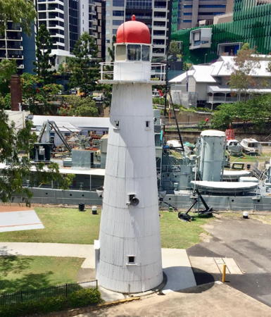
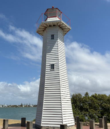
Most of the older lighthouses in Queensland are wood frame towers covered by iron sheets, like the Bulwer Island Light and several others shown below. These towers were built in the late 1800s when there was a need to build a great many lighthouses on the Queensland coast as quickly as possible. Remarkably, at least 16 of these inexpensive lighthouses have survived to the present and 9 remain active.

Coastal lighthouses in Australia are operated by the Australian Maritime Safety Authority (AMSA) but after automation AMSA transferred many of the station properties to the control of local or state authorities or organizations.

ARLHS numbers are from the ARLHS World List of Lights. Admiralty numbers are from volume K of the Admiralty List of Lights & Fog Signals. U.S. NGA numbers are from Publication 111.

General Sources
Queensland Lighthouses
The section of the Lighthouses of Australia site devoted to Queensland lights.
AMSA Heritage Lighthouses
An interactive map links to information and photos for the major AMSA lighthouses.
Lighthouses and Lightvessels in Australia - Queensland
Index to Wikipedia articles; most include photos.
World of Lighthouses - Queensland
Photos by various photographers available from Lightphotos.net.
Leuchttürme in Australien
Photos posted by Andreas Köhler.
Online List of Lights - Australia
Photos by various photographers posted by Alexander Trabas. Michael Boucher and Jim Smith contributed most of the photos from this area.
Queensland State Map
From Australian Geographic.
GPSNauticalCharts
Navigation chart information for Queensland.
Navionics Charts
Navigation chart information for Queensland.


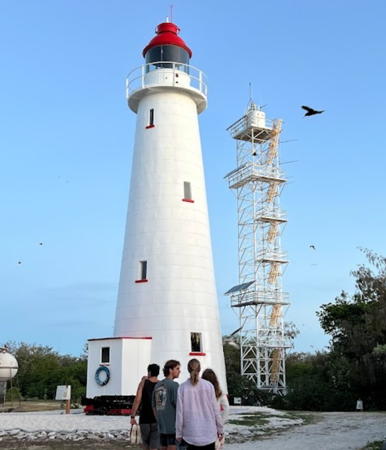
Old and new Lady Elliot Island Lights, November 2021
Google Maps photo by Scottie C

Bundaberg Region Lighthouses
Bundaberg is a city of about 75,000 residents located about 385 km (239 mi) north of Brisbane. The city is at the mouth of the Burnett River and faces the western entrance to Hervey Bay
** Lady Elliot Island (3)
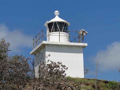
1873 (station established 1866). Inactive since 1995. 18 m (59 ft) wood frame tower covered by galvanized iron panels, with lantern and gallery. Lighthouse painted white; the lantern dome is red. A photo is at the top of this page, Laurin Dodd has a 2007 photo, Wikipedia has an article with several photos, Graham Holland has a photo showing both towers, a 2021 photo of both towers is available, and Google has a satellite view. The original mast light was destroyed by a storm in 1871 and replaced with a temporary light. Lady Elliot Island, located at the extreme southern end of the Great Barrier Reef, is now the site of a popular resort. Located 80 km (50 mi) northeast of Bundaberg. Air transportation is available from Bundaberg and Hervey Bay. Site manager: Great Barrier Reef Marine Park Authority. ARLHS AUS-299.
** Lady Elliot Island (4)
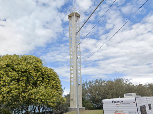
1995 (station established 1866). Active; focal plane 38 m (125 ft); white flash every 7.5 s. 32 m (105 ft) square cylindrical steel skeletal tower with a fiberglass lantern structure and gallery. Lighthouse painted white. A photo is at the top of this page and Wikipedia has a closeup photo. Located close to the historic lighthouse. Operator: AMSA. Site manager: Great Barrier Reef Marine Park Authority. ARLHS AUS-100; Admiralty K2962; NGA 10464.
* Burnett Heads (1) (relocated)
1867 (relocated here in 1873). Inactive since 1971. Approx. 9 m (30 ft) tapered square wood tower with lantern and gallery, painted white; lantern dome is red. The original 5th order Fresnel lens is mounted in the lantern. Wikipedia has an article with Marguerite Carstair's photo, and Google has a street view and a satellite view. This lighthouse was originally built at Comboyuro Point on Moreton Island; it was replaced there by a taller tower and relocated in 1874 to South Head. The lighthouse has been restored and relocated a second time about 1 km (0.6 mi) inland to the Burnett Heads Lighthouse Holiday Park. Local contractors combined to repair and repaint the lighthouse in 2021. Located in Burnett Heads, on the south side of the Burnett River entrance, about 8 km (5 mi) northeast of Bundaberg. Site open, tower closed. Owner/site manager: Bundaberg Regional Council. . ARLHS AUS-281.
* Burnett Heads (2) (South Head)
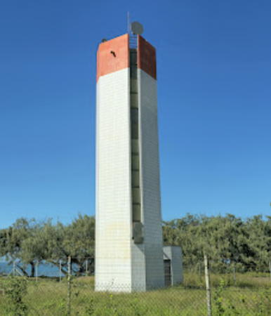
1971. Active; focal plane 20 m (65 ft); four white flashes every 20 s. 18 m (59 ft) square cylindrical tile-covered concrete tower, painted white with a single red band around the top of the tower. No lantern, but in addition to the light the tower carries a dome-shaped receiver for the Cospas-Sarsat satellite-aided search and rescue system, one of two in Australia (the other one is diagonally across the country at Cave Point Light, Western Australia). The octagonal concrete base of the 1873 tower stands next to the current tower. A photo is at right, Trabas has Boucher's photo, Wikipedia has an article, and Google has a street view and a satellite view. Located at the point at the south side of the Burnett River entrance, about 9 km (6 mi) northeast of Bundaberg. Site open, tower closed. Owner/site manager: AMSA. ARLHS AUS-197; Admiralty K2956; NGA 10476.

1971 Burnett Heads Light, Bundaberg February 2014
Google Maps photo by FULL PELT “Pete” Adventures

Fraser Coast Region Lighthouses
Middle Bluff (Woody Island, Big Woody, Maryborough)
1867. Inactive since 1987. 10.5 m (34 ft) hexagonal wood tower with lantern and gallery. Lighthouse painted white, lantern red. Pesach Steinberg has a 2020 photo, a 2006 photo is available and Google has a satellite view. There is also a page on the history of the station and a historic photo (almost halfway down the page) showing the lighthouse and the former keeper's cottage. The lighthouse was restored by Queensland Parks and Wildlife in 2000 but by 2013 it was in rather poor condition due to weather and vandals. In 2016 it was restored again and the park service was seeking community involvement in its future maintenance. Woody Island lies east of the town of Hervey Bay in the entrance to the Great Sandy Strait, which separates Fraser Island from the mainland. The forested island is about 10 km (6 mi) long but only 1 km (0.6 mi) wide. Located atop a ridge near the center of the island. Site open, tower closed. Site manager: Queensland National Parks (Woody Island, Great Sandy National Park). . ARLHS AUS-228.
North Bluff
1867. Inactive since 1959. 10.5 m (34 ft) hexagonal wood tower, formerly with lantern and gallery but now in ruins. This lighthouse was identical to the Middle Bluff lighthouse (previous entry). Kevin Mulcahy has several photos, and Google has an indistinct satellite view. In November 2017 the state government announced a $250,000 grant to restore this derelict lighthouse. We need information on whether this project was carried out; so far no evidence of it has been seen. Located near the northern end of Woody Island. Accessible by a hiking trail. Site open, tower closed. Site manager: Queensland National Parks (Woody Island, Great Sandy National Park). ARLHS AUS-229.
Sandy Cape (K'gari, Fraser Island)
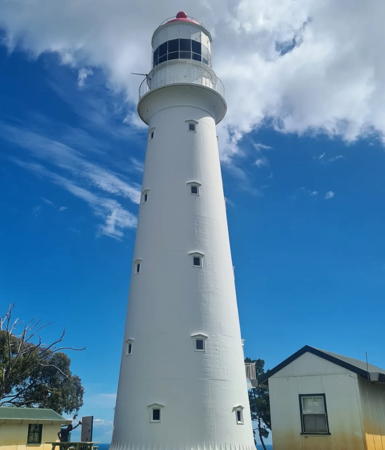
1870. Active; focal plane 128 m (421 ft); white flash every 10 s. 26 m (85 ft) wood frame tower covered by cast iron panels, with lantern and gallery, painted white; lantern dome is red. Two 1-story keeper's houses (1930s) and other light station buildings. A photo is at right, Andrew Morris has a 2017 closeup, Steve Wyeth is a 2021 closeup, a distant view is available, Wikipedia has an article, and Google has a satellite view. The lighthouse was prefabricated by Kitson & Co. in Leeds, England. Said to be the largest sand island in the world, K'gari (Fraser Island) is about 120 km (75 mi) long and up to 25 km (15 mi) wide. The southern half of the island is separated from the mainland by narrow channels, while the northern half extends to form the east side of Hervey Bay. The lighthouse is located in a forested area of the island about 60 km (37 mi) east of Bundaberg and 6 km (3.5 mi) southwest of the northeastern tip of the island. The island is accessible by ferries from Rainbow Beach or Hervey Bay; the light station is accessible by lengthy hikes or 4WD; there is a beach camping area nearby. Operator: AMSA. Site manager: Queensland National Parks (K'grai, Great Sandy National Park). . ARLHS AUS-148; Admiralty K2932; NGA 10488.

Sandy Cape Light, Fraser Island, November 2023
Instagram photo by MV Cape Don/Moreton/Pillar
Hook Point (3?)
Date unknown (station established 1890). Active; focal plane unlisted; white flash every 3 s. Described only as a "white tower." This is a historic light station but no photos of the historic lighthouse or of the current lighthouse have been found. Google has a distant satellite view. Located at the south end of Fraser Island marking the entrance to Wide Bay Harbour. Site open, tower closed. Operator: AMSA. Site manager: Queensland National Parks (K'grai, Great Sandy National Park). Admiralty K2916; NGA 10560.

Gympie Region Lighthouse
Double Island Point
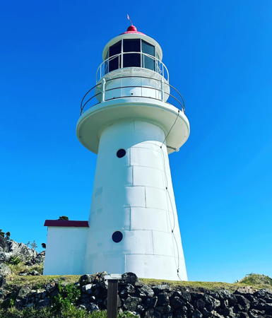
1884. Active; focal plane 96 m (315 ft); white flash 7.5 s. 12 m (40 ft) wood frame tower covered by galvanized iron sheets, with lantern and double gallery; solar-powered lens. Lighthouse painted white; lantern roof is red. Two modern keeper's houses. Neil Pierce's photo is at right, Wikipedia has an article on the station, Peggy Chou has a 2018 photo, a 2008 sunrise photo is available, Darran Fuller has a 2021 photo, and Google has a street view and a satellite view. In 2001 the Noosa Parks Association leased the two keepers houses; they have been restored and are available for overnight accommodations for association members (anyone can join for a small fee, but reservations are required a year in advance). This "insider" arrangement became controversial in 2013 when a new state government questioned the lease process. In 2019 the lease was extended for another 10 years. The Point is a popular site for surfing and whale watching. Located on the summit of Double Island Point at the northern end of the Cooloola beach; accessible by 4WD from Rainbow Beach (about 25 km (15 mi) west). Site open, tower closed. Operator: AMSA. Owner: Queensland National Parks (Great Sandy National Park (Cooloola Recreation Area)). . ARLHS AUS-065; Admiralty K2912; NGA 5660.

Sunshine Coast Region (Caloundra Area) Lighthouses
* Point Cartwright
1978. Active; focal plane 53 m (174 ft); three white flashes every 15 s (red flashes are shown toward the northwest). 32 m (105 ft) pentagonal reinforced concrete tower with concrete lantern. Entire lighthouse is white. Trabas has Boucher's photo, Ross Archer has a 2021 photo, Craig Jewell has a good photo, Sean Woodley has a 2018 photo, Wikipedia has an article for the station, Carly Peart has a street view, and Google has a satellite view. This modern tower replaced the Caloundra Head Light as the major coastal light on the northern approaches to Brisbane. Located on the point, near the mouth of the Mooloolaba River, at the end of Pacific Boulevard in Mooloolaba. Site open, tower closed. Operator/site manager: AMSA. . ARLHS AUS-129; Admiralty K2907.8; NGA 5672.
Double Island Point Light
Double Island Point Light, Rainbow Beach, October 2006
Wikimedia Creative Commons photo by Neil Pierce
** Caloundra Head (1)
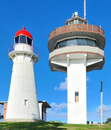
1896. Inactive since 1968. 12 m (39 ft) wood frame tower covered by corrugated iron sheets, with lantern and gallery. Lighthouse painted white; lantern roof is red. Bert Knottenbeld's photo is at right, Wikipedia has an article with Brian Yap's photo, Darren Stones has a nice closeup photo, Alexis Telfer has a 2021 photo, Wikimedia has many historic photos, and Google has a street view and a satellite view. This lighthouse is the oldest building in Caloundra. Threatened with demolition, it was relocated in 1970 by the Golden Beach Power Boat Club to a site next its clubhouse in Woorim Park. Grant Maizels has 1992 photos showing the lighthouse neglected and covered with rust. In 1999 the lighthouse, by then severely deteriorated, was returned to its original site and restored by volunteers and the City of Caloundra. The Lions Club of Caloundra acted as the principal supporter of the preservation effort, helping to organize the Friends of the Caloundra Lighthouses. However, when the group's lease expired in 2009 it lost access to the building. After a year of delays a new lease was granted in December 2010. In early 2011 it was announced that both Caloundra lighthouses would open to the public later in the year. Grant funding supported rehabilitation of both Caloundra lighthouses in 2022. Located on Canberra Terrace near Arthur Street in downtown Caloundra. Site open, tower open to tours every second and fourth Saturday and on other days "if the flag is flying." Owner: National Trust. Site manager: Friends of the Caloundra Lighthouses . ARLHS AUS-253.
** Caloundra Head (2)
1968. Inactive since 1997. Approx. 14 m (46 ft) square cylindrical concrete tower supporting a semicircular signal station, with a lantern mounted on the roof. The lighthouse resembles an airport control tower. Bert Knottenbeld's 2008 photo is at right, Maizels has 1992 photos, Alexis Telfer has a 2021 photo, Wikipedia has an article with Brian Yap's photo, and Google has a street view and a satellite view. The lighthouse was downgraded to a harbor light in 1978 and discontinued in 1997 due to interference from the lights of the growing city. The light was moved atop a building at Wickham Point and then to a signal mast (next entry). Located next to the older lighthouse on Canberra Terrace near Arthur Street in downtown Caloundra. Site open, tower tower open to tours every second and fourth Saturday and on other days "if the flag is flying." Owner: National Trust. Site manager: Friends of the Caloundra Lighthouses . ARLHS AUS-252.
* [Caloundra Head (4)]
Date unknown. Active; focal plane 31 m (102 ft); one long flash every 10 s, white or red depending on direction. 17 m (56 ft) signal mast. Trabas has Boucher's photo and Google has a street view and a satellite view. Located on Victoria Terrace at Wickham Point, the southeasternmost point of Caloundra Head. Site open; parking provided. Admiralty K2856; NGA 5676.
Caloundra Lighthouses
1968 and 1896 Caloundra Lighthouses, September 2008
Flickr Creative Commons photo by Bert Knottenbeld
#Bribie Island (Northwest Channel) Range Front (3)
Date unknown (station established 1896). Removed in 2018. Originally this was a 15 m (49 ft) cylindrical white concrete tower rising from an open concrete enclosure and supporting a platform with gallery. The concrete tower was then replaced by a light on a robust mast mounted on a platform supported by piles. Ché Lydia Xyang has a 2015 photo and Google has a satellite view. However, the light was on the beach and within a few years it was endangered by beach erosion and rising sea level. In June 2018 the tower was removed. The light will not be replaced. Formerly located on The Spit at the northern end of Bribie Island, about 2.5 km (1.5 mi) south of Caloundra Head. Bribie Island is accessible by bridge; The Spit is accessible by 4WD vehicles on the beach. Site open. Site manager: Queensland National Parks (Bribie Island National Park and Recreation Area). ARLHS AUS-185; ex-Admiralty K2857; ex-NGA 5680.
* Bribie Island (Northwest Channel, Golden Beach) (Range Rear) (2)
Date unknown (station established 1896). Active; focal plane 27 m (89 ft); blue light, 1 s on, 1 s off by night; continuous yellow light by day. 19 m (62 ft) cylindrical white concrete tower with gallery but no lantern; four vane-like buttresses. A photo from a Google street view is at right, Grant Maizels has photos on his Caloundra page, and Google has a satellite view. Formerly the rear light of the Bribie Island Range, but the front light was removed in 2018. The range guided vessels leaving Moreton Bay and Brisbane on a long northwest reach. This attractive modern light tower is located at the Esplanade and Gregory Street, on the mainland shore of the Pumicestone Passage about 2.5 km (1.5 mi) southwest of Caloundra Head. Site open, tower closed. Operator/site manager: unknown. ARLHS AUS-186; Admiralty K2857.1; NGA 5684.

Bribie Island Range Rear Light, Caloundra, June 2017
Google Maps street view

Moreton Bay Region Lighthouses
Spitfire Channel Range Front
Date unknown. Active; focal plane 15 m (49 ft); quick-flashing white light. 14 m (46 ft) white concrete tower rising from a square concrete platform supported by piles. Stephen Roe has a 2018 photo and Google has a satellite view. The range guides vessels through a jog in the channel departing Moreton Bay. Located just off the beach in a remote area of southern Bribie Island. Site open, tower closed. Site manager: Queensland National Parks (Bribie Island National Park and Recreation Area). Admiralty K2858.8; NGA 5688.
Spitfire Channel Range Rear
Date unknown. Active; focal plane 23 m (75 ft); white light, 1 s on, 1 s off. 19 m (62 ft) white concrete tower. No photo available but Google has a satellite view. Located 926 m (0.58 mi) west northwest of the front light. Site open, tower closed. Site manager: Queensland National Parks (Bribie Island National Park and Recreation Area). Admiralty K2858.81; NGA 5692.
* Woody Point (Margate)
Date unknown. Active; focal plane 71 m (233 ft); continuous yellow light. Approx. 50 m (164 ft) round cylindrical concrete water tower. Ché Lydia Xyang has a photo and Google has a street view and a satellite view. Located on Sorrento Street near Victoria Avenue in Margate, a suburb on the Redcliffe Peninsula about 26 km (16 mi) north northeast of Brisbane. Site open, tower closed. Admiralty K2866; NGA 5724.

City of Brisbane Lighthouses
Brisbane is the capital of Queensland and the third largest city of Australia with a metropolitan population of about 2.5 million. The center of the city is on the Brisbane River about 15 km (9 mi) from the mouth of the river. The maritime approach to Brisbane is by a long and crooked dredged channel through Moreton Bay that begins near Caloundra about 90 km (56 mi) north of Brisbane.
Brisbane Outbound Range Rear
Date unknown. Active; focal plane 20 m (66 ft); blue light, 2 s on, 2 s off; also a passing light, one quick and one long white flash every 6 s. 20 m (66 ft) square skeletal tower mounted on a robust pile and carrying a triangular white daymark. Trabas has Smith's photo and Bing has an indistinct satellite view. This range guides vessels departing Brisbane. Located in Moreton Bay about 16 km (10 mi) northeast of the harbor entrance. Accessible only by boat. Site open, tower closed. Admiralty K2868.1; NGA 5732.
Brisbane Outbound Range Front
Date unknown. Active; focal plane about 10 m (33 ft); quick-flashing blue light; also a passing light, white light, 2 s on, 8 s off. 10 m (33 ft) skeletal tower mounted on a platform supported by tripod piles and carrying a triangular white daymark. Trabas has Smith's photo and Google has a satellite view. Located in Moreton Bay about 1.6 km (1.0 mi) southeast of the rear light. Accessible only by boat. Site open, tower closed. Admiralty K2868; NGA 5728.
Bulwer Island (Brisbane Entrance, Outer Bar Reach) Range Rear (3)
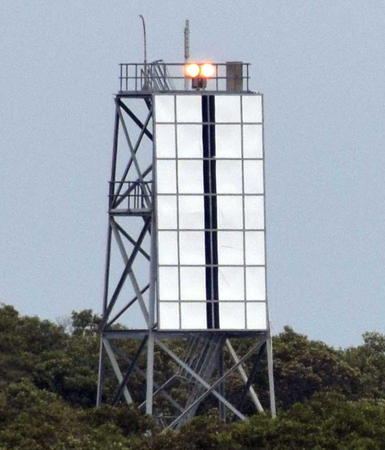
Date unknown (station established 1909). Active; focal plane 25 m (82 ft); blue light, 2 s on, 2 s off; during the daytime a continuous yellow light. Approx. 20 m (66 ft) square cylindrical skeletal tower; the front face of the tower is covered with a rectangular daymark colored white with a black vertical stripe. Trabas has Smith's photo, the Port of Brisbane has a sea view and Google has a satellite view. The front light is on a post. Located behind the oil refinery on the west side of Brisbane River. Site and tower closed. Admiralty K2868.31; NGA 5735.
*** Bulwer Island Range Rear (2) (relocated)
1912 (station established 1909). Inactive since 1983. 16 m (52 ft) octagonal wood frame tower covered by corrugated iron sheets, with lantern and gallery, painted white; lantern painted red. Jeff Hancock's 2023 photo is at right, Kenji Sugisaki has a photo, there's a good photo taken over the lightship (next entry), Lightphotos.net has a photo, and Google has a street view and a satellite view. There's also a good view from the Goodwill Bridge, a pedestrian bridge over the Brisbane River. Originally this was one of a pair of range lighthouses located on an island in the mouth of the Brisbane River. After being replaced by a modern skeletal tower (previous entry) it was relocated about 1983 to a museum setting in downtown Brisbane. The original location is now the site of a large oil refinery. In 2004 a grant from the state government supported a major restoration; the gallery timbers were replaced and the tower was painted inside and out. Among the exhibits of the museum are the original 3rd order Fresnel lens from the Cape Don Light in the Northern Territory and the original Fresnel lens from the 1883 Archer Point Light near Cooktown in Queensland's Far North. Located at the Queensland Maritime Museum on the south side of Brisbane River near the Victoria Bridge. Site and museum open daily; the ground level of the lighthouse is open to visitors. Owner/site manager: Queensland Maritime Museum. . ARLHS AUS-015.

Bulwer Island Light, Brisbane, January 2023
Instagram photo by Jeff Hancock Photography
* Lightfloat CLS-2 Carpentaria
1918. Decommissioned 1985. Single-masted steel lightfloat; length 21.9 m (72 ft), width 7.8 m (26 ft). Entire ship painted red. The ship served in the Gulf of Carpentaria and also in Bass Strait. A good photo is available. This is one of only two surviving Australian lightfloats. Simon Brown's January 2008 photo shows the ship moved to dry dock. It was still there in a November 2008 photo, but a December 2009 photo shows it afloat once more. The lightship sank at its berth during the severe floods of January 2011, but it was refloated and repaired. As of May 2016 Google's satellite view showed the ship in dry dock behind the World War II-era frigate HMAS Diamantina; Lightphotos.net has another photo, and Ciprian Cioaric has a September 2016 street view. According to the museum's web site the ship is currently being restored by volunteers. Located at the Queensland Maritime Museum on the south side of Brisbane River near the Victoria Bridge. Site open, vessel. closed. Owner/site manager: Queensland Maritime Museum. ARLHS AUS-248.

Moreton Island Lighthouses
Located about 60 km (40 mi) northeast of Brisbane and framing the east side of Moreton Bay, Moreton Island is the third largest sand island in the world, 37 km (23 mi) long and up to 13 km (8 mi) wide. Most of the island is set aside as Gheebulum Kunungai (Moreton Island) National Park. Ferry service is available from Brisbane. The island is administered by the City of Brisbane.
Cowan Cowan Point (3)
Date unknown (station established 1860s). Active; focal plane 9 m (30 ft); flash every 2 s, white, red or green depending on direction. 9 m (30 ft) square cylindrical skeletal tower carrying a large daymark colored in a red and white checkerboard pattern. Trabas has Smith's photo, Javier Diago has an aerial view, and Google has a satellite view. The original light was replaced in 1874 by an octagonal wood tower with lantern and gallery; Wikipedia has an 1899 photo. In 1901 the light station was moved 191 m (636 ft) inland to escape beach erosion. The lighthouse was automated in 1950; we do not know when it was demolished. The modern light is a leading light with two sectors, one for vessels arriving in Brisbane and another for vessels departing. Located just off the beach south of Cowan Cowan Point on the west side of Moreton Island. Site open, tower closed. Site manager: Queensland National Parks (Gheebulum Kunungai (Moreton Island) National Park). ARLHS AUS-295; Admiralty K2859; NGA 5844.
North Point Range Front (North Point Hummock) (2)
1939 (station established 1899). Active; focal plane 25 m (82 ft); quick-flashing light, white or red depending on direction. 7 m (23 ft) lantern mounted atop a square 1-story concrete equipment building. John Best's photo is at the bottom of the page, Nari Aduncus has a closeup photo, Trabas has Smith's closeup, Yiran Zhu has a 2021 photo, and Google has a satellite view. The Cape Moreton lighthouse serves as the rear light of this range, which helps vessels sailing along the coast avoid shoals northwest of Moreton Island. According to Wikipedia's article, lights were shown from North Point as early as the 1860s and a corrugated iron lighthouse was built in 1899. Apparently nothing survives of that lighthouse. Located on the northernmost point of Moreton Island. Site open, tower closed. Operator: AMSA. Site manager: Queensland National Parks (Gheebulum Kunungai (Moreton Island) National Park). Admiralty K2854; NGA 5848.
Cape Moreton (North Point Range Rear)
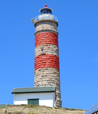
1857 (Edmund Blacket). Active; focal plane 78 m (256 ft); four white flashes, separated by 3.3 s, every 20 s. 23 m (75 ft) sandstone tower with lantern and gallery; solar-powered lens. Lantern painted red, and the tower (otherwise unpainted) has two red horizontal bands painted below the lantern. Two 1-story keeper's houses and additional buildings; resident caretakers occupy at least one of the houses. J. Brew's photo is at right, Wikipedia has an article with a photo by Philip Rickerby, Trabas has Smith's closeup photo, Dandre Nel has a 2023 photo, a 2015 photo is available, Louis Rankin has a street view, and Google has a satellite view. The oldest lighthouse in Queensland and the only one built of stone, this historic tower was built by the New South Wales government two years before Queensland became a separate colony. The tower was extended in 1928-30. The lighthouse also serves as the rear light of the North Point Range. Located at the northeastern tip of Moreton Island, marking the entrance to Moreton Bay and Brisbane. Visitors to the island need a 4WD vehicle and a permit; there is ferry service from Scarborough, and the light station is accessible by 4WD on the beach or overland. Site open, tower closed. Operator: AMSA. Site manager: Queensland National Parks (Gheebulum Kunungai (Moreton Island) National Park. . ARLHS AUS-039; Admiralty K2854.1; NGA 5852.
Cape Moreton Light
Cape Moreton Light, Moreton Island, February 2005
Flickr Creative Commons photo
by J. Brew

Redland City Lighthouses
* Cleveland Point (2)
1864 (station established 1847). Inactive since 1976. Approx. 15 m (50 ft) tapered hexagonal wood tower with lantern and gallery. Lighthouse painted white, lantern red. The Chance Brothers Fresnel lens (1875) is on display at the Redland Museum in Cleveland. Brian Yap's photo is at right, Lighthouses of Australia has a page for the lighthouse, Peter Katsambis has a 2020 photo, a 2009 photo is available, and Google has a street view and a satellite view. Not to be confused with the Cape Cleveland Light near Townsville (see the Central and Northern Queensland page). The lighthouse replaced a small beacon installed in 1847. In 1969 the lighthouse was the site of experiments in the use of lasers as navigational aids. When it was replaced in 1976 it was saved and relocated about 30 m (100 ft) from the new light. The Redland Shire Council (now the Redland City Council) restored the lighthouse in 1987 and has maintained it since. The lighthouse overlooks Moreton Bay on the point, at the end of Shore Street (extension of QLD 22) in Cleveland, about 25 km (15 mi) southeast of Brisbane. Site open, tower closed. Owner/site manager: Redland City Council. . ARLHS AUS-257.
#[Cleveland Point (3)]
1976 (station established 1847). Demolished in 2010. This was a 12 m (39 ft) post light with a small gallery, buttressed with vertical concrete panels. The light was unpainted. John Harvey has a good 2006 photo, Wikipedia has a 2009 photo, and Google has a satellite view of the former location. According to the Wikipedia article, the light was disassembled because it was in the way of filming The Chronicles of Narnia: The Voyage of the Dawn Treader. However, it was not rebuilt after filming concluded. John Kahler visited the site in October 2012 and found only the foundation pad of the light; when Andreas Köhler visited in March 2015 he found even that had disappeared. Located on the extreme point of the cape, close to the historic lighthouse. Site open. Site manager: Redland City Council. ARLHS AUS-130; ex-Admiralty K2898; ex-NGA 5812.
* Point Lookout
1932. Active; focal plane 78 m (256 ft); three white flashes every 15 s. 5 m (16 ft) square concrete tower, painted white; lantern removed. Emily Lu has a 2023 photo, a 2021 photo is available, and Google has a street view and a satellite view. Point Lookout is the northeasternmost point of North Stradbroke Island, a large island located south of Moreton Island, only slightly smaller than Moreton Island; the two are separated by a channel about 3 km (2 mi) wide. North Stradbroke is accessible by car ferry from Cleveland. The point is very popular with surfers and fishermen. Located on a hilltop at the end of Lucinda Crescent in Point Lookout. Accessible by road, with parking at the lighthouse. Site open, tower closed. Operator/site manager: AMSA. ARLHS AUS-195; Admiralty K2852; NGA 5860.

Point Cleveland Light
Point Cleveland Light, Redland, December 2008
Flickr Creative Commons photo by Brian Yap


Coolangatta Area Lighthouse
* Point Danger (Captain Cook Memorial)
1971. Active; focal plane 44.5 m (146 ft); two white flashes every 10 s. 20 m (66 ft) concrete monument, consisting of four pillars marked with the four principal directions of the compass, plus a bronze sculpture suspended between the pillars. An adjoining 1-story building houses the Point Danger Volunteer Marine Rescue station. Wikipedia has an article with a photo, Trabas has Boucher's closeup photo, Fabio Filardi has a 2020 photo, a 2008 photo is available, and Google has a street view and a satellite view. In 2012-13, the Gold Coast City (Queensland) and Tweed Shire (New South Wales) Councils cooperated in a $200,000 project to restore the lighthouse. Located on the point (named by Captain Cook in 1770) southeast of Coolangatta and precisely on the border of Queensland and New South Wales. Site open, tower closed. Operator/site manager: NSW Maritime. . ARLHS AUS-132; Admiralty K2845; NGA 5868.

Information available on lost lighthouses:

  • Comboyuro Point (1874-1960), northwestern tip of Moreton Island. This lighthouse, an octagonal wood tower with lantern and gallery, was moved inland twice (in 1890 and in 1905), but it finally collapsed into the sea in 1960. ARLHS AUS-294.
  • Inskip Point (1880-?), mainland opposite the south end of Fraser Island. This was the location of a pilot station, but there was never a proper lighthouse; the lightkeepers maintained range beacons that were moved as needed for the changing inlet.
  • Lightfloat Breaksea Spit (1981-2000), near Bundaberg. This lightfloat and a replacement for the Carpentaria lightfloat were scuttled in 2000 on the Cochrane Artificial Reef to become habitat for fish.
  • Moreton Bay (Pile Light) (1882-1949), entrance to Brisbane River. Wikipedia has an article on this historic lighthouse, which was destroyed by a collision with the British tanker Wave Protector on 17 October 1949. The lighthouse was replaced, but the replacement beacon was removed in 1967. ARLHS AUS-112.
  • Tangalooma (1892-?), Moreton Island west coast. Described as a square tower in 1904. There are two pairs of range lights at Tangalooma today. ARLHS AUS-301.
  • Yellow Patch (1870s?-?), Moreton Island 800 m (1/2 mi) southwest of the North Point Light.

Notable faux lighthouses:

  •  

North Point Range Front Light, Moreton Island, March 2015
photo copyright John Best; used by permission

Adjoining pages: North: Northern and Central Queensland | East: Coral Sea Islands | South: Northern New South Wales

Return to the Lighthouse Directory index | Ratings key

Posted July 6, 2004; checked and revised January 25, 2024. Lighthouses: 28. Lightfloat: 1. Site copyright 2024 Russ Rowlett and the University of North Carolina at Chapel Hill.