Lighthouses of the Northern Spratly Islands

The Spratly Islands (as they are known historically in the West) are a group of more than 100 islands and reefs spread across an elliptical area 1000 km (625 mi) long and 400 km (250 mi) wide in the South China Sea northwest of Borneo, southwest of the Philippines, and east of Vietnam. The history of the islands is long but poorly known. Historically they were often visited by fishermen but never inhabited permanently. Both China and Vietnam assumed ownership of them. In 1933 France claimed the islands formally as part of French Indochina and China responded by filing its own claim in 1935. During World War II Japan (then in possession of Taiwan) established several bases in the islands. The scramble to exert control of the islands began soon after the war. Presently Vietnam, China, and Taiwan claim all of the islands, the Philippines claims most of them, Malaysia claims some of them, Brunei claims one of them, and Indonesia has economic interests in the area although it has made no formal claims.

Following the reunification of the country in 1975 Vietnam moved quickly to establish a presence in the Spratlys. More recently China has occupied many of the islands and established several large bases. Taiwan, Malaysia, and the Philippines also occupy several islands. All five countries have established navigational lights in the Spratlys and Vietnam and China have built multiple major lighthouses. These lights do have navigational value but they are also built as assertions of sovereignty, even though international tribunals have ruled several times that building a lighthouse does not establish ownership of an island.

Please note that the Lighthouse Directory does not express support for any nation in the disputes over this area. The only purpose of this page is to list and describe the lighthouses of the islands. They are grouped by geography. The various reefs are identified by their "international" (that is, Western) names. Each island is identified by the name used by the occupying nation with the Western name in parentheses.

In China, including Taiwan, the South China Sea is called the South Sea (Nán Hǎi) and the Spratlys are called the Nánshā Islands. The People's Republic's territories are attached administratively to Hǎinán Province. In 2012 China announced the creation of the prefectural-level city of Sānshā, including the Paracel Islands (Xīshā) and the Nánshā Islands. Taiwan's territories are administered as part of Kaohsiung City.

In Vietnam the South China Sea is called the East Sea (Biển Đông) and the Spratlys are called Trường Sa. The Vietnamese territories are administered as a county of Khánh Hòa Province.

In the Philippines the South China Sea is called the West Philippine Sea and the Spratlys are called the Kalayaan Islands. The Philippine territories are administered as the Kalayaan municipality of Palawan Province.

Malaysia uses the translated Western names of the South China Sea (Laut Cina Selatan) and Spratly Islands (Kepulauan Spratly). The Malaysian territories are administered by Sabah state.

This page includes lighthouse on the reefs and islands north of latitude 9° north. The Southern Spratly Islands page covers the rest of the archipelago.

ARLHS numbers are from the ARLHS World List of Lights. Admiralty numbers are from volume F of the Admiralty List of Lights & Fog Signals. U.S. NGA List numbers are from Publication 112.
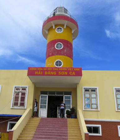

Sơn Ca Light, Tizard Bank, April 2013
Google Maps photo by Trọng Tâm Đào
General Sources
Online List of Lights - Spratly Islands
Photos by various photographers posted by Alexander Trabas.
Spratly Islands Map
A useful map posted by the University of Texas Library.
Southern Vietnam Maritime Safety - Lighthouses
Links to pages on the individual light stations.
Quần đảo Trường Sa (Spratly Islands)
This article in the Vietnamese language edition of Wikipedia has greater detail than any other known Internet source on the history and status of the individual islands; it is written from the Vietnamese point of view, of course.
MSA South Navigation Service Center
This branch of China's Maritime Safety Administration manages navigational aids in the South China Sea. In 2022 the center released postcard views of China's lighthouses in the islands.
南沙群岛 (Nánshā qúndǎo)
Chinese Wikipedia's article on the islands.
Kalayaan, Palawan
This English-language Wikipedia article presents the islands from the Philippines point of view and includes a map of the islands posted by the Philippines government.
Municipality of Kalayaan-Palawan - Islands
Aerial views of the islands occupied by the Philippines.
Vietnam Spratly Islands
This Flickr.com group has photos of several of the Vietnamese lighthouses.
Spratly Islands (Kepuluan ng Kalayaan)
Slideshow on the Spratlys from a Philippine poimt of view.
Malaysia Island Tracker
From the Asia Maritime Transparency Initiative, aerial photos of the five Malaysian installations.
Who Occupies What in the Spratly's?
From The Diplomat, lists of islands occupied by each country as of 2016.
GPSNauticalCharts
Navigational chart of the islands.


Yǒngshǔ Jiāo Light, Fiery Cross Reef, November 2016
PRC Xinhua News Agency photo

Northern Islands Lighthouses

North Danger Reef Lighthouse
The northernmost of the major reefs, North Danger Reef is an atoll about 15 km (9 mi) in diameter.

Philippines: Parola Cay (Northeast Cay) (?)
Date unknown. Active; focal plane 7 m (23 ft); two red flashes every 10 s. No description and no photo available but the light may be on the tower of the 2-story building seen in Wikimapia's 2012 photo. Google has a satellite view of the station. Philippines Naval Forces West has an aerial view of the island. Northeast Cay has an area of 12.7 ha (31.4 acres). Philippine forces occupied both Northeast and Southwest Cays in 1968 but they were ejected from Southwest Cay by South Vietnamese troops in 1974. A few months later, when Saigon fell to North Vietnamese forces, the South Vietnamese garrison on Southwest Cay swam 2.8 km (1.75 mi) to Northeast Cay to escape capture. The Philippines maintains a garrison on Northeast Cay. Its Philippine name Parola means Lighthouse. Site and tower closed. PCG-0763; Admiralty F2825; NGA 20289.
Vietnam: Song Tử Tây (Southwest Cay)
1993. Active; focal plane 38 m (125 ft); white flash every 15 s. 36 m (118 ft) round concrete tower with lantern and gallery, rising from the center of a multistory station building. Lighthouse painted white. Dao Ngoc's 2015 photo is at right, a 2013 photo is available, Bui Tuan Khiem has a photo, Southern Vietnam Maritime Safety has another photo, Wikimedia has a distant view, and Google has a satellite view. Southwest Cay is a 12 ha (30 acre) island, one of the largest in the northern Spratlys. It was claimed by France in 1933 and occupied by the Philippines in 1968 but a Vietnamese naval operation took the island in 1974. Vietnam began development of a major base on the cay soon thereafter and built its first Spratly Islands lighthouse here in 1993. The buildings include a fishing village accommodating as many as 400 residents; there is also a primary school. The Vietnamese name means West Twin Island. Site and tower closed. ARLHS SPR-007; Admiralty F2824.5; NGA 20289.2.
Vietnam: Đá Nam (South Cay)
Date unknown. Active; focal plane 8 m (26 ft) (?); white flash every 5 s. Approx. 12 m (39 ft) octagonal crew building topped by a 2 m (7 ft) skeletal mast. Dao Ngoc has a photo of the station and Google has a fuzzy satellite view. Located on a tiny scrap of land at the southwestern end of the reef. Site and tower closed. Admiralty F2824.3.

Song Tử Tây Light, North Danger Reef, May 2015
Google Maps photo by Dao Ngoc

Thitu Reef Lighthouse
Philippines: Pagasa Island (Thitu Island) (2?)
1976 (?). Active; focal plane unknown; white flash every 5 s. In 2019 the Admiralty announced a new light described as a "white concrete tower." No photos of this new lighthouse are available. Until recently the light was on a 25 m (82 ft) square cylindrical white concrete skeletal tower with a roofed gallery; the light appeared to be mounted atop the roof. A fuzzy photo is available. This tower served as an observation tower at the military airstrip built on the island in 1976 by the Phillipines Air Force. Subsequently the light was moved atop a communications tower with red and white horizontal bands. Philippines Naval Forces West has a 2022 photo of that tower and an aerial view of the island, and Google has a satellite view. In 2020 the communications tower was repurposed as a cellphone tower. Thitu Reef is about 20 km (13 mi) long, oriented west to east about 45 km (27 mi) south of North Danger Reef. Pagasa Island, the only dry land on the reef, is the second largest of the Spratlys with an area of 37.2 ha (92 acres). It is the principal base for the Philippines in the archipelago. A permanent population has settled on the island, forming a community called Kalayaan; the population was 193 in 2020. In 2007 the air force announced plans to rehabilitate the airstrip with an eye to encouraging development of the island as a beach resort. The Philippine name Pagasa means Hope; the Western name Thitu is probably a corruption of an older Chinese name Tiězhì. Located at the center of the reef. Site open, tower closed. ARLHS SPR-010; Admiralty F2824; NGA 20289.6.

Subi Reef Lighthouse
China: Zhǔbì Jiāo (Subi Reef) (2)
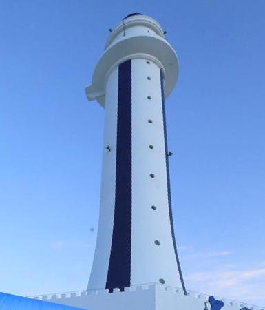
2015. Active; focal plane 55 m (180 ft); white flash every 5 s. 55 m (180 ft) tapered round concrete tower with lantern and gallery. Lighthouse painted white with black vertical stripes. A photo is at right and Google has a satellite view. This lighthouse replaced a 20 m (66 ft) octagonal cylindrical concrete tower with lantern and gallery. According to a statement by the Philippines Defense Ministry, the original lighthouse dated from "at least" 2002. Subi Reef is a small atoll about 5 km (3 mi) in diameter, located 26 km (16 mi) southwest of Pagasa Island. Originally Subi Reef was completely underwater at high tide, but China has created artificial islands around most of its circumference. China occupied the reef in 1988 and has built a military base with an airstrip and numerous buildings. The airstrip is on the west side of the atoll; the lighthouse is on the east side, and an entrance was blasted through the reef on the south side. Expansion of the land area was continuing in 2021. Site and tower closed. Admiralty F2825.02; NGA 20289.62.

2015 Zhǔbì Jiāo Light, April 2016
PRC Xinhua News Agency photo

Loaita Bank Lighthouse
Philippines: Panata (Lankiam Cay)
2019. Active; focal plane unknown; white flash every 10 s. No description and no photo available. Philippine Naval Forces West has an aerial view of the station and Google has a satellite view. The Loaita Bank is an atoll 37 km (23 mi) long located about 32 km (20 mi) southeast of Thitu. The principal Philippine base on the bank is on Loaita (Kota) Island, a 6.45 ha (15.9 acre) island at the south end of the bank but the light is on Lankiam Cay, the smallest naturally ocurring island of the Spratlys at 0.44 ha (1.1 acre). The name Panata mean Oath. Located on the northwest side of the atoll. Site and tower closed. Admiralty F2825.04.

West York Island Lighthouse
Philippines: Likas (West York Island)
2018. Active; focal plane unknown; two white flashes every 8 s. No description and no photo available but Google has a satellite view of the station and Philippine Naval Forces West has an aerial view of the island. West York (Likas) Island is the third largest island of the Spratlys with an area of 18.6 hectares (46 acres). It is an isolated island at the northeastern edge of the archipelago 78 km (49 mi) east of Thitu. The Philippines maintains a small military detachment on the island and has announced plans to build a settlement, intended as the second village of its Kalayaan municipality. The name Likas means Natural. The lighthouse was built at the west end of the island. Site and tower closed. Admiralty F2823.8.

Flat Island Bank Lighthouse
Philippines: Patag
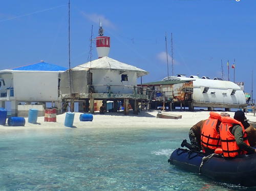
2018. Active; focal plane about 8 m (26 ft); white flash every 5 s. Approx. 8 m (26 ft) round barbell-shaped fiberglass tower colored with red and white horizontl bnds. Philippine Naval Forces West has the photo seen at right and Google has a satellite view of the station. There is a photo of two buildings of the station but the light had not been added at that time. The Flat Island Bank, about 160 km (100 mi) east of Thitu, is at the northeastern corner of the Spratlys; it has only specks of dry land, Patag (Flat Island) in the north and Lawak (Nanshan) Island in the south. The Philippines stationed small military detachments on both islands as early as 1968. Barely more than a sandbar, Patag Island covers 0.57 hectares (1.4 acres). Site and tower closed. PCG-0849; Admiralty F2823.255.

Patag Light, Flat Island Bank, April 2020
Facebook photo by Philippines Naval Forces West

Central Islands Lighthouses

Tizard Bank Lighthouses
Located in the north central part of the Spratly Islands, Tizard Bank is a large, mostly-submerged atoll, 60 km (37 mi) long and 21 km (13 mi) wide. The bank is about 75 km (47 mi) almost due south of Pagasa Island. It was named for Thomas Henry Tizard, the British oceanographer who surveyed the atoll in the 1860s.

Vietnam: Đá Núi Thị (Petley Reef, Petly Reef)
Date unknown. Active; focal plane 8 m (26 ft) (?); three white flashes, in a 2+1 pattern, every 12 s. Approx. 12 m (39 ft) octagonal crew building topped by a 2 m (7 ft) skeletal mast. A photo is available and Google has a satellite view. Located on a tiny islet in the reef, about 15 km (9 mi) northeast of the main Vietnamese base on Sand Cay (next entry). Site and tower closed. Admiralty F2823.26.
Vietnam: Sơn Ca (Sand Cay)
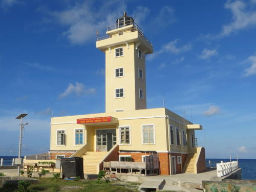
2009. Active; focal plane 28 m (92 ft); two flashes every 10 s, alternately yellow and red. 25.5 m (84 ft) round cylindrical concrete tower with lantern and gallery, rising from a 2-story station building. Lighthouse painted with yellow and red horizontal bands. Trọng Tâm Đào's 2013 closeup is at the top of this page, Dốc Cơ also has a 2013 photo, and Google has a satellite view. Sand Cay is a 7 ha (17 acre) island on the north side of the Tizard Bank, about 12 km (7.5 mi) east of the Taiwanese base of Taiping Dao. The history of the island is unclear; South Vietnam occupied it as early as 1974 but the present Vietnamese base here is relatively new. The island has been enclosed by a seawall and covered with buildings. Site and tower closed. Admiralty F2823.3.
Taiwan: Taiping Dao (Itu Aba Island)
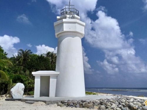
2015. Active; focal plane about 18 m (59 ft); flashing white light. 14 m (45 ft) round white concrete tower. A photo is at right, the Maritime and Port Bureau posted another photo, and Google has a satellite view. Taiping (Itu Aba) is the largest of the Spratly Islands, 1.4 km (0.9 mi) long and with an area of 46 ha (114 acres). There are various references to a lighthouse on the island as early as the 1940s, but they have not been confirmed. Japan, which ruled Taiwan from 1895 to 1945, seized the Spratlys in 1941 and established a naval base on Itu Aba. At the end of World War II in 1945 the Nationalist Chinese warship Taiping arrived to take the surrender of the Japanese garrison. The Nationalist (Republic of China) government took over the Japanese base and has occupied it continuously since 1956. Presently the island has a landing strip, a coast guard station, a weather station, and about 600 troops and government personnel. In December 2014 it was announced that a new lighthouse would be built on the island; it was placed in service in November 2015. Taiwan also administers the Zhongzhou Reef east of Taiping Island, and there are plans to place a navigational light on that reef. The island is on the north side of the Tizard Bank. Site and tower closed. ARLHS SPR-013; Admiralty F2823.5; NGA 20289.64.

Taiping Dao Light, Tizard Bank, December 2016
ROC Maritime and Port Bureau photo
China: Nánxūn Jiāo (North Gaven Reef)
Date unknown (1988?). Active; white light; characteristic unknown. Light mounted on a short mast atop a 5-story military outpost. Structure painted white with red trim. Tâm Dzao has a 2020 photo of the station and Google has a satellite view. The reef is at the west end of the Tizard Bank, about 10 km (6 mi) west of Namyit Island. In its natural condition the reef was underwater at high tide. In 2014 China began using fill to expand the base, creating an artificial island with an area of about 8 ha (20 acres). Site and tower closed.
China: Nánxūn Jiāo Range Front
Date unknown. Active; light characteristics unknown. Approx. 12 m (39 ft) square concrete tower painted white with black vertical stripes. No photo available but Google has a satellite view. This is an entrance range for the station. Located just off the south side of the island. Site and tower closed.
China: Nánxūn Jiāo Range Rear
Date unknown. Active; light characteristics unknown. Approx. 22 m (72 ft) square concrete tower painted white with black vertical stripes. This tower is on the right in Tâm Dzao's photo and Google has a satellite view. Located just off the south side of the island, about 100 m (110 yd) behind the front light. Site and tower closed.
China: Nánxūn Jiāo Entrance North
Date unknown. Active; green light, pattern unknown. Approx. 9 m (30 ft) concrete tower. No photo available but Google has a satellite view. Located just off the southeast end of the expanded island. Site and tower closed.
China: Nánxūn Jiāo Entrance South
Date unknown. Active; red light, pattern unknown. Approx. 9 m (30 ft) concrete tower. No photo available but Google has a satellite view. Located on a reef opposite the north light. Site and tower closed.
Vietnam: Nam Yết (Namyit Island)
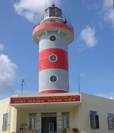
2010 (?). Active; focal plane 25 m (82 ft); three white flashes every 15 s. 23 m (75 ft) round cylindrical concrete tower with lantern and gallery, rising from a 2-story station building. Lighthouse painted with red and white horizontal bands. Dao Ngoc's 2015 closeup is at right, a 2013 closeup is available, and Google has a satellite view of the station. A sibling of the Sơn Ca lighthouse. Namyit Island is a 6 ha (15 acre) island at the south end of the Tizard Bank, about 25 km (15 mi) south of Taiping Dao. The island has been occupied by Vietnam since 1973. Site and tower closed. Admiralty F2823.4; NGA 20289.68.

Nam Yết Light, Tizard Bank, May 2015
Google Maps photo by Dao Ngoc

Discovery Great Reef Lighthouses
Discovery Great Reef (Đá Lớn) is a narrow reef about 18 km (11 mi) long, extending north to south, about 50 km (30 mi) southwest of North Gaven Reef. The reef is completely underwater at high tide. Vietnam began building on the reef in 1988 and has built installations at several locations along its length.

Vietnam: Đảo Đá Lớn (Discovery Great Reef) B
Date unknown. Active; focal plane 8 m (26 ft) (?); three white flashes every 12 s. Light on a tripod atop a 3-story station building. A photo (fifth photo on the page) is available and Google has a satellite view. Located near the north end of the reef. Admiralty F2823.12.
Vietnam: Đảo Đá Lớn (Discovery Great Reef) A
Date unknown. Active; focal plane 8 m (26 ft) (?); white flash every 4 s. Light on a tripod atop a 3-story station building. A photo (first photo on the page) and a second photo are available, and Google has a satellite view. Located near the southeast end of the reef. Admiralty F2823.1.
Vietnam: Đảo Đá Lớn (Discovery Great Reef) C
Date unknown. Active; focal plane 8 m (26 ft) (?); two white flashes every 10 s. Light on a tripod atop a 3-story station building. No photo available but Google has a satellite view. Located near the southwest end of the reef. Admiralty F2823.15.

Union Banks Lighthouses
Union Banks is a large, rather narrow atoll located about 30 km (19 mi) south of the Tizard Bank. The reef is 55 km (34 mi) long and up to 15 km (9 mi) wide.

Vietnam: Sinh Tồn (Sin Cowe Island)
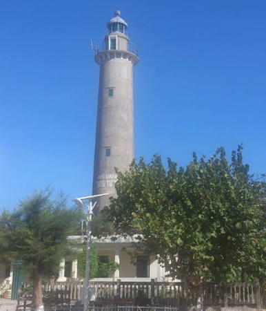
2010 (?). Active; focal plane about 25 m (82 ft); three red flashes, in a 2+1 pattern, every 15 s. 23 m (75 ft) square cylindrical concrete tower with lantern and gallery, rising from a 2-story station building. Lighthouse painted yellow with white trim. Trọng Tâm Đào's 2013 photo is at right, a closeup photo (second photo on the page), two photos and additional photos are available, and Google has a satellite view of the station. Sin Cowe is a 3 ha (8 acre) island on the north side of the Union Banks. Vietnam occupied the island in 1974 and has maintained a base there ever since. The settlement includes housing, a primary school, and a Buddhist pagoda. The Vietnamese name means Survival Island. Site and tower closed. Admiralty F2823.2; NGA 20289.7.

Sinh Tồn Light, Union Banks, April 2013
Google Maps photo by Trọng Tâm Đào
Vietnam: Đảo Cô Lin (Collins Reef, Johnson North Reef)
Date unknown. Active; focal plane 8 m (26 ft) (?); four white flashes, in a 3+1 pattern, every 12 s. Light on a tripod atop a 3-story station building. Wikipedia has a photo and Google has a satellite view. The Johnson Reefs are at the southwestern end of the Union Banks. Located on an artificial islet inside the northern reef, also known as Collins Reef. Site and tower closed. Admiralty F2823.205.
China: Chìguā Jiāo (Johnson South Reef) (2)
2015 (station established late 1980s). Active; focal plane about 52 m (171 ft); white flash every 8 s. 50 m (164 ft) round concrete tower with lantern and gallery. Sibling of the Huáyáng Jiāo lighthouse (see the Southern Spratly Islands page). A photo is at right, Hồng Xuân has fuzzy 2020 view from th sea, and Google has a satellite view. This lighthouse replaced a light mounted on a short mast atop a 3-story military outpost; a photo (1/3 the way down the page) is available. Johnson South Reef is at the southwestern end of the Union Banks. China's base dates from 1988, when Chinese forces seized the island from Vietnam. In 2013-14 China began a large land reclamation project that is providing the foundation for a military base and airfield. Site and tower closed. Admiralty F2823.21; NGA 20290.12.
Vietnam: Đảo Len Đao
Date unknown. Active; focal plane about 20 km (66 ft); light characteristic unknown. Crew building topped by a 2 m (7 ft) skeletal mast. Another article has a photo and Google has a satellite view. When Vietnamese forces came to occupy this location in March 1988 they were attacked by a Chinese warship; one of the Vietnamese ships was sunk. The initial engagement was not conclusive, but Vietnam returned and established an outpost. Located on an islet (originally submerged at high tide) on the south side of the Tizard Bank. Site and tower closed. Admiralty F2823.24.
China: Rǎnqīng Shāzhōu (Grierson Reef, Sin Cowe East Island)
Date unknown. Active; focal plane and light characteristic unknown. Light mounted on a station building. A view from the sea (fifth photo on the page) is available and Google has a satellite view. Located on a small island on the southeast side of the reef. Site and tower closed. Admiralty F2823.25.
 

Chìguā Jiāo (Johnson South Reef) Light, May 2017
PRC Navy photo
 

Mischief Reef Lighthouse
China: Měijì Jiāo (Mischief Reef)
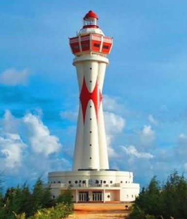
2016. Active; white light; characteristic unknown. Approx. 60 m (197 ft) octagonal hourglass-shaped concrete tower carrying a lantern and a large observation room. The lighthouse is white with red diamond-shaped markings; lantern is red. A photo is at right and Google has a satellite view. Mischief Reef is an isolated atoll about 100 km (63 mi) east of the Union Banks and 240 km (150 mi) west of the Philippine island of Palawan. The atoll is submerged at high tide. Beginning in 1994 China built a substantial base on the south side of the atoll, including a 3-story station. In 2015 China began filling land all around the northern half of the atoll to create a major base including an airstrip. These activities are of grave concern to the Philippines since the reef is inside the Philippines 200 mile economic exclusion zone. The lighthouse is on the north side of the atoll. Site and tower closed. Not listed by the Admiralty.

Fiery Cross Reef Lighthouses
China: Yǒngshǔ Jiāo (Fiery Cross Reef, Northwest Investigator Reef) (1)
Date unknown. Active; focal plane 13 m (43 ft); two white flashes every 6 s. 13 m (43 ft) round white concrete tower. A photo is available and Google has a satellite view. China occupied the reef in 1988 (after chasing away some Vietnamese ships). The expanded island covers about 2.74 square kilometres (1.06 sq mi), making it the largest island in the archipelago. It has become a major Chinese military base supporting operations throughout the South China Sea. Westerners named Fiery Cross Reef for the British tea clipper Fiery Cross, which wrecked on the reef in March 1860. The reef is about 150 km (90 mi) west southwest of the Union Banks and 100 km (60 mi) northwest of Pearson Reef. Located just off the southeastern end of the islet. Site and tower closed. CN-5201; Admiralty F2825.165.
China: Yǒngshǔ Jiāo (Fiery Cross Reef, Northwest Investigator Reef) (2)
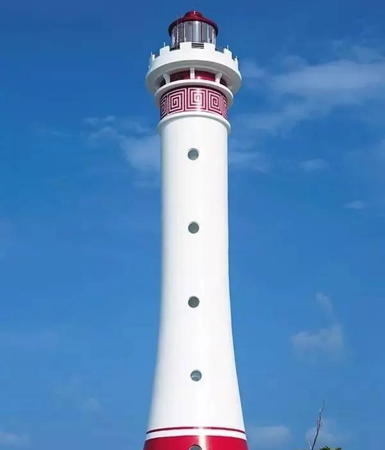
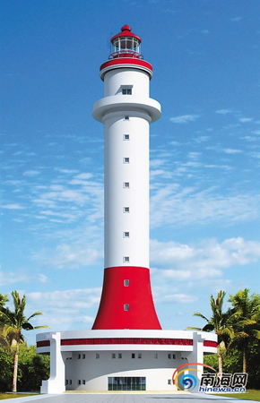
2016. Active; focal plane 29 m (95 ft) (?); white flash every 4 s. 32 m (105 ft) tapered round concrete tower with lantern and gallery. Lighthouse is white with red trim and a red band at the base; lantern is also red. A photo is at the top of this page and Google has a satellite view. Located on the south side of the harbor entrance, at the northeast end of the base. Site and tower closed. CN-5200.5; Admiralty F2825.17; NGA 20289.8.
China: Yǒngshǔ Jiāo Entrance North
Date unknown. Active; focal plane about 12 m (39 ft); green light, pattern unknown. Approx. 10 m (33 ft) round concrete tower. No photo available but Google has a satellite view. Located on a short breakwater on the north side of the entrance. Site and tower closed.
China: Yǒngshǔ Jiāo Entrance South
Date unknown. Active; focal plane about 12 m (39 ft); red light, pattern unknown. Approx. 10 m (33 ft) round concrete tower. No photo available but Google has a satellite view. Located on a short breakwater on the south side of the entrance. Site and tower closed.

Měijì Jiāo (Mischief Reef) Light
unattributed photo from xuehua.us

Information available on lost lighthouses:

Notable faux lighthouses:

Adjoining pages: North: Xisha (Paracel Islands) | East: Southwestern Philippines | South: Southern Spratly Islands | West: Southern Vietnam

Return to the Lighthouse Directory index | Ratings key

Posted April 24, 2006. Checked and revised March 24, 2025. Lighthouses: 30. Site copyright 2025 Russ Rowlett and the University of North Carolina at Chapel Hill.