Lighthouses of Sweden: Tanum Area (Northern Bohuslän)

The Kingdom of Sweden (Sverige in Swedish) is the largest country of northern Europe, occupying the entire west coast of the Baltic Sea. Along with its lengthy coast Sweden has a distinguished lighthouse history and a good record of preserving its historic lights. The Swedish Lighthouse Society (Svenska Fyrsällskapet) works actively for the preservation of the lighthouses.

Sweden is divided into 21 counties (län) and the counties are subdivided into townships and municipalities (kommuner). Bohuslän is the coastal region (and a former province) at the westernmost edge of Sweden, including the coast between Göteborg and the Norwegian border. Since 1998 the region has been included in the large county of Västra Götaland. Roughly 150 km (90 mi) long, the coastline of Bohuslän faces west on the Skagerrak, the broad channel that separates Norway and Sweden from Denmark. It is a rocky coastline with countless small islands and skerries creating hazardous conditions for sailors. It's not surprising that it requires a great many small lights, most of them located offshore. This page covers the lighthouses of the northern part of Bohuslän, including the municipalities of Sotenäs, Tanum, and Strömstad.

The Swedish word for a lighthouse is fyr. The front light of a range is the nedrefyr (lower light) and the rear light is the övrefyr (upper light). Ö is an island, holme is an islet, skär is a skerry (a tiny island or rocky reef), sund is a strait (often between an island and the mainland), vik is a bay, hav is a sea, udde is a headland, and hamn is a harbor.

Aids to navigation in Sweden are maintained by the Swedish Maritime Administration (Sjöfartsverket).

I'm indebted to Michel Forand for providing excellent information for this page, including information from one of the books in his collection: Viktoria Ask and Maria Sidén, Fyrguide från Kattholmen till Smygehuk (2000).

ARLHS numbers are from the ARLHS World List of Lights. SV numbers are from the Sjöfarsverket light list as reported by the Swedish Lighthouse Society. Current Admiralty numbers are from volume C of the Admiralty List of Lights & Fog Signals (the lights in Tanum and Strömstad were formerly in Volume B). U.S. NGA List numbers are from Publication 116.

General Sources
Swedish Lighthouse Society (Svenska Fyrsällskapet, SFA)
The Society is active in promoting the preservation of Swedish lighthouses.
SFA Fyrwiki - Bohuskusten Norra
From the SFA web site, articles and photos on the lighthouses of the Skagerrak.
Online List of Lights - Sweden
Photos by various photographers posted by Alexander Trabas.
Leuchttürme und Leuchtfeuer in Schweden - Svenska Fyrar
A large collection of photos and data posted by Erich Hartmann; text in German.
Lighthouses in Sweden
Photos by various photographers available from Wikimedia.
World of Lighthouses - Sweden
Photos by various photographers available from Lightphotos.net.
Lighthouses in Sweden
Aerial photos posted by Marinas.com.
Schwedische Leuchttürme auf historischen Postkarten
Historic postcard views posted by Klaus Huelse.
Navionics Charts
Navigation chart information for Bohuslän.
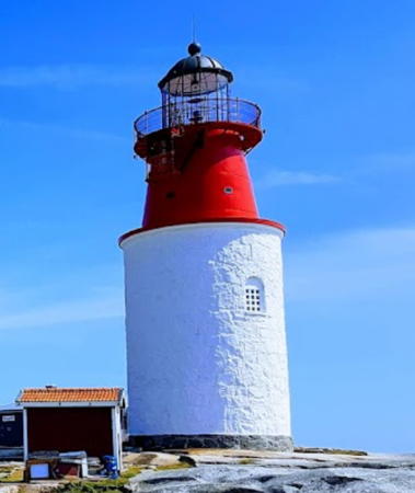

Hållö Light, Sotenäs, July 2019
Google Maps photo by Freddy Lövdahl
Sotenäs Municipality Lighthouses

Bohus-Malmön Area Lighthouses
Snurran (2) (relocated to Svensholmen)
About 1920 (relocated in 2003). Inactive since 2002 (a decorative light is displayed); although the light is unlisted the lantern is also floodlit at night and is charted as a navigational aid. Approx. 7 m (23 ft) tower with lantern and gallery, painted white. This is the original Svensholmen lighthouse, previously located near Skalhamn (see Central Bohuslän). SFA has a page for the Snurran light and also a page for the Svensholmen station (established 1890). Replaced by a modern light in 2002, it was purchased by a group of lighthouse fans, the Snurrans Fyrförening (Snurran Lighthouse Association), and relocated to Bohus-Malmön by helicopter in August 2003. The association has several photos, another photo is available, and Google has a satellite view. Located on a small island on the Malmön waterfront; the island is accessible by a bridge. Site open, tower closed. Owner/site manager: Snurrans Fyrförening på Bohus-Malmön . ex-SV-8314; ex-Admiralty C0379.
* Fisketången Övre
1942. Active; focal plane 21 m (69 ft); continuous red light. 6 m (20 ft) mast carrying a triangular daymark and mounted on a round solid stone cairn. Cairn painted white. SFA has a page for the range lights, Trabas has a photo, and Google has a street view and a satellite view. The front light is atop a similar cairn. Located on the Hallindenvägen in Fisketången, a fishing town in the Kungsholm community. Site open, tower closed. SV-8338.01; Admiralty C0364.1 NGA 0312.
* Breviksudden Nedre (2)
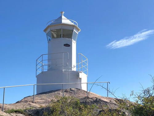
1972 (station established 1940). Active; focal plane 8 m (26 ft); white, red or green light, depending on direction, 1.5 s on,1.5 s off. 4 m (13 ft) octagonal lantern, painted white, mounted on a concrete pad. Trabas has a closeup photo, Hartmann has a page for the light, and Google has an indistinct satellite view. The original rear light was on a pedestal mounted on a square base, but in 2022 it was replaced by a slender skeletal tower. Located on a promontory of the mainland about 2 km (1.2 mi) northeast of Bohus-Malmön. Site open, tower closed. SV-8330; Admiralty C0360; NGA 0356.

Snurran Light, Bohus-Malmön, August 2018
Instagram photo by Snurransfyr Official

Smögen Area Lighthouses
* Hållö
1842 (height increased in 1868). Active; focal plane 40 m (131 ft); white flash every 12 s. 20 m (66 ft) round cylindrical rubblestone tower surmounted by a conical cast iron watch room, lantern and gallery. The stone tower is painted white, the cast iron red, and the lantern black. Freddy Lövdahl's photo appears at the top of this page, Hartmann has a page for the lighthouse, SFA also has a page, Trabas has a closeup by Klaus Kern, Feddy Lövdahl has a 2019 photo, Mark Espen has a 2023 photo, Wikimedia has photos and views from the sea, Marinas.com has aerial photos, Huelse has a historic postcard view, and Google has a satellite view. The cast iron stage and lantern were added to the original stone tower in 1868, and the keeper's house of the Klövskär lighthouse was relocated here in 1936. Hållö is an island in the Skagerrak about 2.5 km (1.5 mi) southwest of Smögen. The Hållö Lighthouse Association (Föreningen Hållö Fyr ) is working to renovate and restore the lighthouse; it is now available for weddings and other special events. The island and several nearby islets have been included in a nature reserve, and tours of the reserve are available from Sotenäs. Located on the east side of the island, guiding vessels toward Sotenäs. Site open, tower normally closed but guided tours can be arranged and the lighthouse is open during the International Lighthouse Weekend on August. Site manager: Hållöarkipelagen Naturreservat. . ARLHS SWE-173; SV-8357; Admiralty C0375; NGA 0276.
Mjölskär
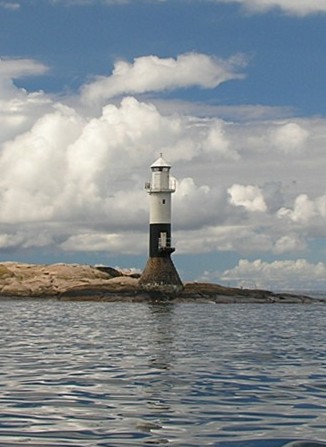
1936. Active; focal plane 14 m (46 ft); flash every 3 s, white, red or green depending on direction. 14 m (46 ft) round cylindrical tower with lantern and gallery, mounted on a round conical stone base. Tower painted white with a black horizontal band at the bottom; lantern painted white; stone base unpainted. A photo is at right, Ron Schroeder has a photo, Trabas has a distant view, Hartmann has a page for the lighthouse, and Google has a satellite view. The lighthouse replaced the Klövskär lighthouse. Located on a skerry about 4 km (2.5 mi) northwest of Smögen. Accessible only by boat. Site open, tower closed. ARLHS SWE-280; SV-8408; Admiralty C0352; NGA 0240.

Hunnebostrand Area Lighthouses
Söö Övre (2)
1972 (station established 1936). Active; focal plane 14 m (46 ft); white, red or green light depending on direction, 2 s on, 2 s off. 6 m (20 ft) tower with lantern and gallery. Lighthouse painted white, lantern roof red. Trabas has a photo, Hartmann has a page for the range lights, Matz Söderberg has a view from the sea, and Google has a satellite view. The front light is much smaller. Located on an island about 1.5 km (1 mi) west of Hunnebostrand. Accessible only by boat. Site open, tower closed. SV-8427.01; Admiralty C0344.1; NGA 0224.
* Ulebergshamn (Skålholmen (1) relocated)
1936 (relocated in 2011). Active; focal plane 6 m (20 ft); continuous white light. 4 m (13 ft) octagonal cast iron lantern. When the Skålholmen light was replaced by a modern fiberglass light (see below), the original lantern was restored and placed on the short breakwater in Ulebergshamn, a village just north of Hunnebostrand. Hartmann has a page for the light, Rolf Solhaug has a 2018 photo, and Google has a satellite view. Site open, tower closed. Admiralty C0344.2.

Mjölskär Light, Smögen, August 2005
Flickr Creative Commons photo by thriol

Tanum Municipality Lighthouses

Hamburgsund Area Lighthouses
Sotens Svartskär (2)
1956 (station established 1884). Active; focal plane 7 m (23 ft); three flashes every 9 s, white, red or green depending on direction. 7 m (23 ft) round cylindrical concrete tower with an octagonal lantern and gallery. Entire lighthouse painted white. SFA has a page for the lighthouse, Trabas also has a photo, and Google has a satellite view. Located on a skerry about 1 km (0.6 mi) off the northwestern point of Hamburgö, marking the entrance to the narrow channels leading to Hamburgsund. Accessible only by boat. Site open, tower closed. ARLHS SWE-361; SV-8446; Admiralty C0339 (ex-B2118); NGA 0204.
* Sandviksholmen
1939. Active; focal plane 10 m (33 ft); two flashes every 6 s, white, red or green depending on direction. 7 m (23 ft) round cylindrical concrete tower with an octagonal lantern and gallery. Lighthouse painted white, lantern roof red. Trabas has an excellent photo, SFA has a page for the lighthouse, and Google has a satellite view. Located on the north end of a small island off north side of the island of Hamburgö. Site open, tower closed. ARLHS SWE-336; SV-8449; Admiralty C0338 (ex-B2120); NGA 0200.
Skålholmen (2)
2011 (station established 1936). Active; focal plane 14 m (46 ft); flash every 6 s, white, red or green depending on direction. 9 m (30 ft) round cylindrical fiberglass tower with lantern and gallery, painted white. Håkan Gånge has a 2021 photo and Bing has a satellite view. This light marks the east side of a group of dangerous skerries, with Väderöbod marking the west side. The original light, an octagonal cast iron lantern, was restored and installed at Ulebergshamn (see above). Located on a skerry 3.5 km (2.2 mi) east of the Väderöbod lighthouse. Accessible only by boat. Site open, tower closed. SV-8469; Admiralty C0334 (ex-B2127); NGA 0196.
Väderöbod (2)
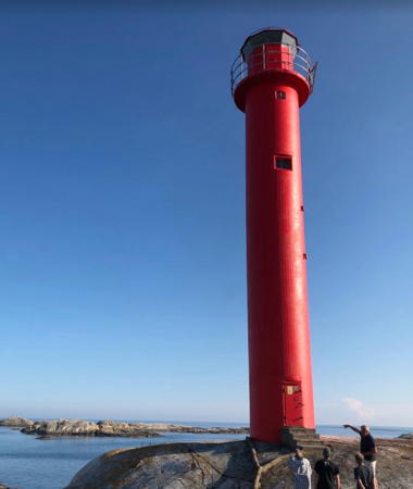
1964 (station established 1867). Active; focal plane 32 m (105 ft); one long flash every 8 s, white, red or green depending on direction. 19 m (62 ft) round cylindrical concrete tower with lantern and gallery, painted red. Volunteers help maintain two 1-story keeper's houses and other light station buildings. The original (and unusual) 2nd order Fresnel lens is on display at the Hembygdsmuseum in Fjällbacka. Tellef Øgrim's photo is at right, Mats-Ola Persson has a good photo, and Google has a satellite view. The present lighthouse replaced a cast iron skeletal lighthouse with central cylinder built by Gustav von Heidenstam. Huelse has a postcard view of that lighthouse. Located on a small rocky island in the Skagerrak about 15 km (9 mi) west southwest of Fjällbacka. Accessible only by boat. Site open, tower closed. . ARLHS SWE-409; SV-8466; Admiralty C0335 (ex-B2126); NGA 0192.

Väderöbod Light, Skagerrak, July 2019
Google Maps photo by Tellef Øgrim

Fjällbacka Area Lighthouses
Testholmen
1939. Active; focal plane 5 m (16 ft); quick flashing white, red or green light, depending on direction. 4 m (13 ft) round lantern mounted on a round concrete foundation. Lantern painted white. Ron Schroeder has a photo and Google has a satellite view. Located at the north end of an island about 2.5 km (1.5 mi) west of Fjällbacka. Accessible only by boat. Site open, tower closed. SV-8461; Admiralty C0328 (ex-B2134); NGA 0176.
Brände Holmen (Bränteholmen)
1909. Active; focal plane 17 m (56 ft); quick-flashing light, white, red or green depending on direction. 7 m (23 ft) tower with lantern and gallery, mounted on a concrete base. Lighthouse painted white. No photo available but Google has a satellite view. Located at the southern end of Brände Holmen, a small island about 4 km (2.5 mi) west of Fjällbacka. Accessible only by boat. Site open, tower closed. SV-8488; Admiralty C0330 (ex-B2132); NGA 0168.
Södra Syster (2)
2020 (station established 1951). Active; focal plane 14 m (46 ft); two flashes every 6 s, white, red or green depending on direction. 9 m (30 ft) white fiberglass tower. Google has a satellite view. This prefabricated light replaced a cylindrical tower with lantern and gallery, mounted on a round stone base. Lighthouse painted white, base black. The SFA page has a photo of the earlier light. Located on a small island about 7 km (4.5 mi) west of Fjällbacka. Accessible only by boat. Site open, tower closed. SV-8485; Admiralty C0331 (ex-B2131); NGA 0164.

Grebbestad Area Lighthouses
Djupskär
1959. Active; focal plane 9 m (30 ft); three flashes every 9 s, white, red or green depending on direction. 6.5 m (21 ft) white fiberglass tower. Google has an indistinct satellite view. This prefabricated light replaced a concrete tower with lantern and gallery, painted white with a black horizontal band. Mats Reuterswärd has a view of the earlier light from the sea. Located on a skerry about 1.6 km (1 mi) southwest of Otterö. Accessible only by boat. Site open, tower closed. SV-8506; Admiralty C0322 (ex-B2140); NGA 0160.
Stångeskär (2)
1939 (station established 1890). Active; focal plane 9 m (30 ft); flash every 3 s, white, red or green depending on direction. 7 m (23 ft) round lantern mounted on a round concrete base. Lantern painted white, base black. Google has a satellite view. The original lighthouse was a 4 m (13 ft) square wood building; the light was displayed from a short post attached to a gable. Located on a skerry off the southwestern tip of Pinnö. Accessible only by boat. Site open, tower closed. SV-8510; Admiralty C0320 (ex-B2142); NGA 0132.

Havstenssund Area Lighthouses
Väcker (Tjurpannan)
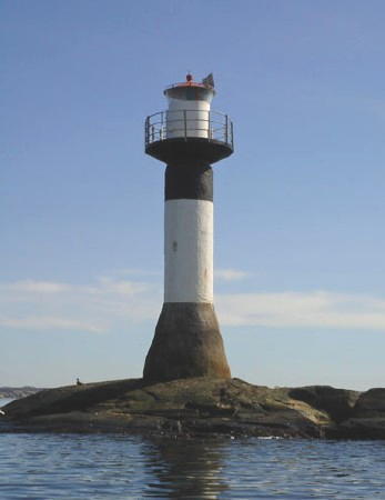
1939. Active; focal plane 14 m (43 ft); four flashes every 12 s, white, red or green depending on direction. 14 m (43 ft) round cylindrical tower with lantern and gallery, mounted on a round conical stone base. Tower painted white with a black horizontal band at the top; lantern painted white with a red roof; stone base unpainted. A photo is at right, Hartmann has a page for the lighthouse, SFA also has a page, Trabas has a photo, Hans Boström has a good photo, and Google has a satellite view. Located on a skerry in the Skagerrak about 3 km (2 mi) south southwest of Havstenssund. Accessible only by boat. Site open, tower closed. . ARLHS SWE-407; SV-8530; Admiralty C0314 (ex-B2149); NGA 0128.
* Havstenssund Nedre (2)
1939 (station established 1890). Active; focal plane 11 m (36 ft); white, red or green light, depending on direction, 2 s on, 2 s off. 4 m (13 ft) lantern and gallery, mounted on a round concrete base. Lantern painted white with a red roof. SFA has a page for the lighthouse, Trabas has a good photo, Rikke Lind has a photo, and Google has an indistinct satellite view. Located on a steep cliff at the southwestern corner of Havstenssund, where it guides ships into the harbor. Accessible by a hiking trail and boardwalk. Site open, tower closed. SV-8537; Admiralty C0312; NGA 0120.

Väcker Light, Havstenssund, December 2008
Wikimedia Creative Commons photo by Ingth25
Ramskär
1917. Active; focal plane 19 m (62 ft); three flashes every 9 s, white, red or green depending on direction. 19 m (62 ft) round cylindrical concrete tower with lantern and gallery, painted white with one broad black horizontal band. A twin of the Väcker lighthouse. SFA has a page for the lighthouse and Google has a satellite view. There were requests for a light on this reef for many years, but because of the difficulties of construction a decision was made to the build the Svangen lighthouse (see below) instead. This proved inadequate, and a light was finally authorized for Ramskär as well. Located on a rock in the Skagerrak about 10 km (6 mi) due west of Havstenssund. Accessible only by boat. Site open, tower closed. ARLHS SWE-316; SV-8614; Admiralty C0308 (ex-B2155); NGA 0116.
Bissen (2)
1939 (station established 1884). Active; focal plane 8.5 m (28 ft); two flashes every 6 s, white, red or green depending on direction. 7 m (23 ft) concrete tower with lantern and gallery. Lighthouse painted white; lantern roof painted red. Hartmann has a page for the lighthouse, SFA also has a page, Wikimedia has a photo, Trabas has a photo showing only the lantern, and Google has an indistinct satellite view. Located on the southern tip of Bissen, marking a narrow passage between that island and the island of Store Snart, about 600 m (0.4 mi) west of the western point of Resö. Accessible only by boat. Site open, tower closed. SV-8546; Admiralty C0310 (ex-B2153); NGA 0114.
Svangen (3)
1983 (station established 1889). Active; focal plane 21 m (69 ft); flash every 3 s, white, red or green depending on direction. 4 m (13 ft) round white lantern mounted on a round concrete base. 1-1/2 story wood keeper's house, painted red except the upper story of the front of the house is painted white as daymark. Wikimedia has a view from the sea by Thomas Eliasson (a portion is seen at right), SFA has a page for the lighthouse, Anders Wockatz has a 2022 closeup of the lantern, and Google has a satellite view. The original light was mounted on the keeper's house; it was replaced by a freestanding tower in 1923. The keeper's house was sold in 1957 and is a private summer residence; the rest of the island is a nature preserve. Located on a rocky island in the Skagerrak about 3 km (2 mi) west of Resö. Accessible only by boat. Site status unknown. . SV-8617; Admiralty C0306; NGA 0112.

Svangen Light, Resö, April 2009
Wikimedia Creative Commons photo by Thomas Eliasson

Strömstad Municipality Lighthouses

Kosteroarna (Koster Islands) Lighthouses
The two Koster Islands, 10 km (6 mi) west of Strömstad, are the westernmost inhabited territories of Sweden. The permanent population of about 300 is increased greatly by vacationers during the summer. Transportation to the islands is available from Strömstad.

Ursholmen Syd
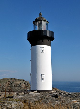
1891. Active; focal plane 33 m (108 ft); two long flashes every 15 s, white, red or green depending on direction. 13 m (42 ft) round concrete tower with lantern and gallery. Lighthouse painted white with a black horizontal band at the top; lantern painted black. A photo is at right, SFA has a page for the light station, a 2010 photo shows the lighthouse freshly repainted, another excellent closeup photo is available, Wikimedia has several photos, Linus Lundin has a street view, and Google has a satellite view. The Ursholmen lights are Sweden's westernmost lighthouses; they were built to replace the pair at Nord Koster (see below). The two lighthouses were the first built of concrete in Sweden. In 2008 the Sjöfartsverket transferred the two lighthouses to the Naturvårdsverket (the Swedish environmental protection agency) along with funds for their restoration. The restoration was underway late in 2008 and was completed in 2009. Ursholmen is an islet in the Skagerrak about 3 km (1.8 mi) southwest of Syd Koster; the island is a protected nature reserve. Accessible only by boat, but there is a distant view from Syd Koster. Site open, tower closed. Owner: Naturvårdsverket. Site manager: Stiftelsen Ursholmen. . ARLHS SWE-404; SV-8608; Admiralty C0304 (ex-B2159); NGA 0096.
Ursholmen Nord
1891. Inactive since 1931. 10 m (33 ft) round concrete tower, painted white with a black horizontal band at the top; the lantern was removed in 1932. Erik Sjöstedt has a closeup photo, Marinas.com has aerial photos, Huelse has a historic postcard view of both lights in service, Linus Lundin has a street view, and Google has a satellite view. This lighthouse was repaired after it was gutted by fire in 1920. Accessible only by boat, but there is a distant view from Syd Koster. Site open, tower closed. Owner: Naturvårdsverket. Site manager: Stiftelsen Ursholmen. ARLHS SWE-403.
Sneholm
1939. Active; focal plane 12 m (39 ft); flash every 3 s, white, red or green depending on direction. 11 m (36 ft) round cylindrical concrete tower with lantern and gallery. Lighthouse painted white with a black horizontal band under the gallery. Hartmann has a page for the lighthouse, Trabas has a photo, Henry Law has a view from the sea, and Google has a satellite view. Located on an islet about 1 km (0.6 mi) off the east coast of Syd Koster. Accessible only by boat. Site open, tower closed. ARLHS SWE-357; SV-8569; Admiralty C0291 (ex-B2176); NGA 0064.
Ursholemen Fyr Syd
Ursholmen Syd Light, Syd Koster, August 2009
Flickr Creative Commons photo by thriol
* Nord Koster (Nordkoster) Syd
1849. Reactivated (inactive 1891-2001); focal plane about 65 m (214 ft); four long (2 s) white flashes every 30 s. Approx. 7 m (23 ft) round masonry tower with lantern. Lighthouse painted white; lantern painted gray. Gordon Pettersson's 2021 photo is at right, Hartmann has a page for the Nord Koster lighthouses, Wikimedia has a photo, Trabas has Hartmann's view from the sea, and Google has a street view and a satellite view. Nord Koster is one of two islands in the Skagerrak about 5 km (3 mi) west of Tjärnö and a short distance south of the Norwegian border. Huelse has a historic postcard view of the twin lighthouses built on the island in 1849. The lighthouses were deactivated in 1891 in favor of the Ursholmen Fyr. This tower was restored in 2000 and reactivated in February 2001. Located on the highest point of island, near the center. The island is accessible by ferry from Strömstad. Site open, tower closed. SV-8639.02 (ex-8642); Admiralty C0295. (ex-B2171).
* Nord Koster (Nordkoster) Nord
1849. Inactive since 1891. Approx. 5 m (17 ft) round masonry tower with lantern. Lighthouse painted white. Hartmann has a page for the Nord Koster lighthouses, Trabas has Hartmann's view from the sea and Google has a street view and an indistinct satellite view. Huelse has a historic postcard view of the twin lighthouses built on Nord Koster in 1849. The lighthouses were deactivated in 1891 in favor of the Ursholmen Fyr. This tower was restored in the 1930s but is poor condition today. The two towers are about 70 m (78 yd) apart. Located on the highest point of island, near the northern end. The island is accessible by ferry from Strömstad. Site open, tower closed.

Strömstad Area Lighthouses
Strömstad (Killingsholmen)
1924. Active; focal plane 7 m (23 ft); flash every 3 s, white, red or green depending on direction. 4 m (13 ft) round lantern, painted white with a red roof. SFA has a page for the lighthouse, Trabas has a photo, and Bing has a satellite view. Located on Nord-Långö, an island in the entrance to Strömstad harbor. Accessible only by boat. Site open, tower closed. SV-8595; Admiralty C0282 (ex-B2187); NGA 0028.
Klövningarna (Nedre)
1926. Active; focal plane 11 m (36 ft); white, red or green light depending on direction, 2 s on, 2 s off. 6 m (20 ft) round masonry tower with lantern and gallery, painted white; lantern roof painted red. No closeup photo available but Bing has a satellite view. Located on a skerry about 1.6 km (1 mi) north of Nord Koster. Accessible only by boat. Site open, tower closed. SV-8648; Admiralty C0280 (ex-B2190); NGA 0012.

Nordkoster Syd Light, June 2021
Google Maps photo by permission

Kebal Area Lighthouses
Tjurholmsknappen (Tjurholmen) (2)
1914 (station established 1884). Inactive. 4 m (13 ft) round masonry tower; lantern removed. Lighthouse painted white with a black horizontal band at the top. A 2009 closeup is available, Geocaching.com also has a closeup, and Google has a satellite view. Tjurholmen faces the Norwegian island of Søndre Sandøy across a channel about 1.2 km (3/4 mi) wide. Located on an island about 3 km (1.8 mi) northwest of Kebal. Accessible only by boat. Site open, tower status unknown.
Tjurholmsknappen (Tjurholmen) (3)
1939 (station established 1884). Active; focal plane 14 m (46 ft); two flashes every 6 s, white, red or green depending on direction. 8 m (26 ft) round cylindrical tower with lantern and gallery. Entire lighthouse is white. Trabas has a photo, SFA has a page for the lighthouse, and Bing has an indistinct satellite view. Located on a skerry about 1 km (0.6 mi) south of the previous lighthouse. Accessible only by boat. Site open, tower closed. SV-8656; Admiralty C0279 (ex-B2197); NGA 0008.

Information available on lost lighthouses:

Notable faux lighthouses:

Adjoining pages: North: Norway Østfold | South: Uddevalla Area

Return to the Lighthouse Directory index | Ratings key

Created March 18, 2007. Checked and revised March 13, 2024. Lighthouses: 30. Site copyright 2024 Russ Rowlett and the University of North Carolina at Chapel Hill.