Lighthouses of Sweden: Western Bothnia

The Kingdom of Sweden (Sverige in Swedish) is the largest country of northern Europe, occupying the entire west coast of the Baltic Sea. Along with its lengthy coast Sweden has a distinguished lighthouse history and a good record of preserving its historic lights. The Swedish Lighthouse Society (Svenska Fyrsällskapet) works actively for the preservation of the lighthouses.

Sweden is divided into 21 counties (län) and the counties are subdivided into townships and municipalities (kommuner). This page covers lighthouses of Västerbotten (Western Bothnia) county (Västerbottens Län) in northern Sweden. Västerbotten faces the northern end of the Gulf of Bothnia. This northernmost extension of the Baltic Sea is known in Sweden as the Bothnian Bay (Bottenviken). It is shallow, with numerous shoals and islands, creating a need for many navigational aids. The southern part of Västerbotten faces a narrower section of the Gulf known as the Norra Kvarken (northern throat or northern strait).

The Swedish word for a lighthouse is fyr. The front light of a range is the nedrefyr (lower light) and the rear light is the övrefyr (upper light). Ö is an island, holme is an islet, skär is a skerry (a tiny island or rocky reef), grund is a shoal or shallow, sund is a strait (often between an island and the mainland), vik is a bay, hav is a sea, udde is a headland, flod is a river, and hamn is a port or harbor.

Aids to navigation in Sweden are maintained by the Maritime Administration (Sjöfartsverket).

ARLHS numbers are from the ARLHS World List of Lights. SV numbers are from the Sjöfarsverket light list (Fyrlista) as reported by the Swedish Lighthouse Society. Admiralty numbers are from volume C of the Admiralty List of Lights & Fog Signals. U.S. NGA List numbers are from Publication 116.

General Sources
Swedish Lighthouse Society (Svenska Fyrsällskapet, SFA)
The Society is active in promoting the preservation of Swedish lighthouses.
Svenskt Fyrväsende
From the SFA web site, data and photos for many of the lighthouses.
Online List of Lights - Sweden
Photos by various photographers posted by Alexander Trabas.
Leuchttürme und Leuchtfeuer in Schweden - Svenska Fyrar
A large collection of photos and data posted by Erich Hartmann; text in German.
World of Lighthouses - Sweden
Photos by various photographers available from Lightphotos.net.
Lighthouses in Sweden
Photos by various photographers available from Wikimedia.
Sweden Lighthouses
Photos posted by Marinas.com.
Schwedische Leuchttürme auf historischen Postkarten
Historic postcard views posted by Klaus Huelse.
Navionics Charts
Navigation chart for Sweden.


Pite-Rönnskär Light, Skellefteå, July 2015
SFA Creative Commons photo by Esbjörn Hillberg
Skellefteå Lighthouses
Nygrån (2)
1970 (station established 1958). Active; focal plane 19 m (62 ft); white, red or green light, depending on direction, 2 s on, 6 s off. 21 m (69 ft) round concrete tower with lantern and gallery. Lighthouse painted white with one black horizontal band. A 2014 photo is available but the lighthouse is not shown in Google's satellite view. There's also a drawing of the original lighthouse, which was overthrown by ice in 1969. Located on a shoal in the Gulf of Bothnia about 12 km (7.5 mi) southeast of Jävrebyn and about 6 km (4 mi) east of the Pite-Rönnskär lighthouse. (It's not clear if this is in Västerbotten or Norrbotten.) Accessible only by boat. Site open, tower closed. ARLHS SWE-297; SV-0477; Admiralty C5789; NGA 11476.
* Pite-Rönnskär (2)
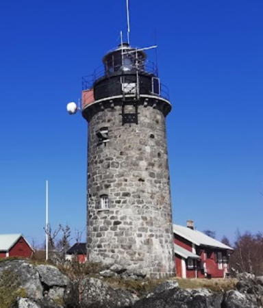
1862 (relocated here in 1905; this station established 1880). Reactivated (inactive 1958-2005, now privately maintained); focal plane 37 m (121 ft); three white flashes every 15 s. 37 m (121 ft) round cast iron skeletal tower with lantern, gallery, and central cylinder. The original rotating 3rd order Fresnel lens is in use. Entire lighthouse painted red. Esbjörn Hillberg's photo is above, the Lighthouse Society has a page for the lighthouse, a closeup photo is available, Huelse has a historic postcard view, Elin Eriksson has a 2020 street view, and Google has a satellite view. This is the tallest of the Heidenstam class skeletal towers. Originally the lighthouse was one of twin towers at Sandhammaren in Scania. It was deactivated there is 1891, dismantled in 1904, and rebuilt here in 1905. The lighthouse marked the beginning of the approach to Piteå; it was deactivated in 1958 in favor of the Nygrån Fyr, which was built farther out in the gulf. The lighthouse was reactivated in 2005 (its 100th anniversary on Pite-Ronnskär) through the efforts of summer residents who have cabins on the island. The light station buildings are part of a youth hostel. Located on an island about 8 km (5 mi) southeast of Jävrebyn. Accessible only by boat; passenger ferry service from Kinnbäck is available. Site open, tower closed. . ARLHS SWE-329; SV-0470.1; Admiralty C5797.5.
* [Rönnskär Beacon]
Date unknown. Inactive daybeacon. Approx. 20 m (66 ft) conical wood skeletal tower topped by a tall cross and carrying a daymark of red and white horizontal bands. John Rangtveit has a photo and Google has a satellite view. Located on the eastern tip of Rönnskär, about 250 m (820 ft) southeast of the lighthouse. Site open, tower closed.
Bergskäret (2)
1972 (station established 1893). Inactive since 2022. 7 m (23 ft) round concrete tower with lantern and gallery. Tower painted white, lantern red. Trabas has a photo, Ingela Jonsson has a lovely 2019 photo, the Lighthouse Society has a page for the light, and Google has a satellite view. The original light was in a round lantern. Located on an island on the south side of the entrance to the Kagefjärd, about 8 km (5 mi) northeast of Skellefteå. Site status unknown. ARLHS SWE-090; ex-SV-0615; ex-Admiralty C5805; NGA 11460.
Gåsören (1) (Gamla Gasören)
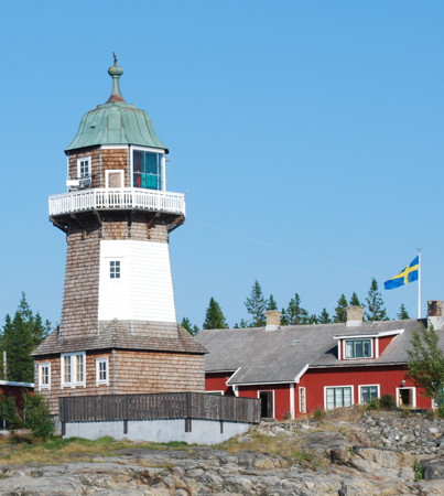
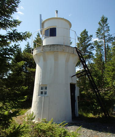
1881. Reactivated (inactive 1921-2003, now privately maintained); focal plane 11 m (36 ft); white light occulting once every 10 s. 9.5 m (31 ft) lantern and gallery mounted at one end of a 1-1/2 story wood keeper's house. Lighthouse painted white; lantern roof is greenish metallic. A photo is at right, Trabas has a photo, a 2008 photo is available, and Google has a satellite view. The building continued in use as the keeper's house for the 1921 lighthouse. In 1992 the lighthouse was acquired by the Skellefteå section of the Svenska Kryssarklubben (Swedish Seacruising Club). The club restored the building and reactivated it, although its light is primarily decorative. Located on an island off the entrance to Skelleftehamn, the harbor of Skellefteå. Accessible only by boat. Site open, tower closed. ARLHS SWE-148; Admiralty C5810.5; NGA 11384.2.
Gåsören (2)
1921 (station established 1881). Active; focal plane 18 m (59 ft); two long (2 s) flashes every 12 s, white, red or green depending on direction. 13 m (43 ft) round cylindrical concrete tower with lantern and gallery. Lighthouse painted white with a red horizontal band under the gallery. A photo is at right, a 2008 closeup is available, Trabas has a photo, Hartmann has a page for the lighthouse, Marinas.com has aerial photos, and Google has a satellite view. Located near the historic lighthouse, on an island off the entrance to Skelleftehamn, the harbor of Skellefteå. Accessible only by boat. Site open, tower closed. . ARLHS SWE-017; SV-0634; Admiralty C5810; NGA 11384.

Gåsören Lights, Skellefteå, July 2021
Instagram photo by asasresor
Kopparudden
1990. Active; focal plane 12.5 m (41 ft); flash every 3 s, white, red or green depending on direction. 6.5 m (21 ft) round cylindrical concrete tower with lantern and gallery. Tower painted orange, lantern white. Trabas has a photo and Google has a satellite view. Located in an industrial area at the north side of the entrance to Skelleftehamn, the harbor of Skellefteå. Site status unknown. SV-0636; Admiralty C5813; NGA 11388.
** Bjuröklubb
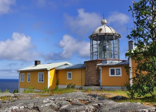
1859 (pilot station established 1821). Active; focal plane 51 m (167 ft); white light, 8 s on, 2 s off. 7.5 m (25 ft) octagonal cylindrical stone tower with lantern and gallery, attached to a 1-story keeper's house and pilot station. Original 2nd order Fresnel lens in use. The tower is unpainted; lantern dome painted white, house painted yellow. David Forsman's photo is at right, Hartmann has a page with several photos, Trabas has a closeup photo, Peter Samuelsson has a 2008 photo, Huelse has a historic postcard view, Marinas.com has aerial photos, Adam Velebil has a 2016 street view, and Google has a satellite view. This historic light station is the landfall light for Skellefteå, marking the south entrance to an embayment leading to the town. Renovated in 2006-07, the station now includes a café and conference center, with overnight accommodations available. The surrounding area is a nature preserve with hiking trails. Bjuröklubb itself is a headland marking the division between the Bothnian Bay and the Norra Kvarken (Northern Strait). Located on a promontory about 15 km (9 mi) northeast of Lövånger. Site open, café open in the afternoon daily mid June through mid August, tower closed. Site manager: Bjuröklubbs Fyr . ARLHS SWE-094; SV-0697; Admiralty C5826; NGA 11356.
Bjuröklubb Northeast (2)
1939. Inactive since 2018 and possibly removed. 4 m (13 ft) octagonal lantern mounted on a round concrete pad. Trabas has a photo, Hartmann has a page for the light, and Google has a satellite view. Located on the northeast corner of the Bjuröklubb promontory, about 400 m (1/4 mi) northeast of the historic lighthouse. Site open, tower closed. ex-SV-0697.1; ex-Admiralty C5828; NGA 11360.
Bjuröklubb Fyr
Bjuröklubb Light, Skellefteå, July 2009
Flickr Creative Commons photo by David Forsman
Munkviken (Munkvik)
1940. Active; focal plane 6 m (20 ft); continuous light, white, red or green depending on direction. 5 m (17 ft) square wood lantern house supported by piles. Trabas has a photo, Hartmann's page has a good photo, a twilight photo is available, and Google has a distant satellite view. Located on the waterfront at Munkviken. Site open, tower closed. SV-0717; Admiralty C5834; NGA 11340.
Blackkallen (2)
1921 (station established 1907). Inactive since 2014. 13 m (43 ft) round cylindrical concrete tower with lantern and gallery, mounted on a conical concrete base. Lighthouse painted white with one black horizontal band. Trabas has a distant view, Marinas.com has aerial photos, and Bing has a satellite view. Located on a small island about 10 km (6 mi) east of Lövånger. Accessible only by boat. Site open, tower closed. ex-SV-0706; ex-Admiralty C5832; ex-NGA 11352.
Kallviksklubben
1952. Active; focal plane 9 m (30 ft); quick-flashing white light, white, red or green depending on direction. 5 m (17 ft) square tower with a round lantern and gallery. Entire lighthouse painted white. Trabas has a photo, SFA has a page for the lighthouse, and Google has a satellite view. Located on a skerry about 40 km (25 mi) northeast of Ratan. Accessible only by boat. Site open, tower closed. SV-0737; Admiralty C5833; NGA 11328.

Robertsfors Lighthouses
Vannskär (Ytre Vannskär)
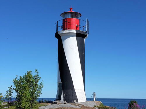
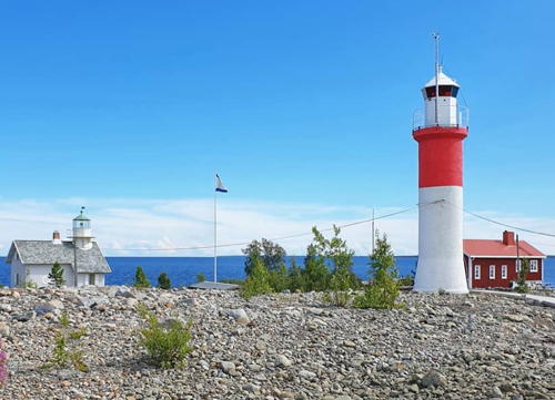
1920. Active; focal plane 15 m (49 ft); three flashes every 9 s, white, red or green depending on direction. 11.5 m (37 ft) cast iron tower with lantern and gallery, mounted on a concrete base. Tower painted with black and white spiral bands (very unusual for Sweden), lantern painted red. Tomas Berglund's photo is at right, Trabas has a distant view, Marinas.com has aerial photos, and Google has a satellite view. Located on an island about 8 m (5 mi) east of Sikeå Hamn. Accessible only by boat. Site open, tower closed. ARLHS SWE-416; SV-0730; Admiralty C5840; NGA 11324.
Rata Storgrund
1975. Active; focal plane 16 m (52 ft); two flashes every 6 s, white, red or green depending on direction. 17 m (56 ft) round cylindrical concrete tower with lantern and gallery. Upper half of lighthouse painted white, lower half red. Sven-Erik Hilberer has a closeup photo and Bing has a distant satellite view. Located on a shoal in the Gulf of Bothnia about 10 km (6 mi) due east of Ratan. Accessible only by boat. Site open, tower closed. ARLHS SWE-318; SV-0751; Admiralty C5847; NGA 11308.

Vannskär Light, Robertsfors, July 2018
SFA Creative Commons photo by Tomas Berglund
Rataskär (Ratanskär, Ratan Nedrefyr) (2)
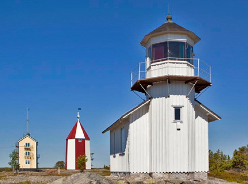
1890 (station established 1874). Active; focal plane 26 m (85 ft); white, red or green light, depending on direction, 6 s on, 2 s off, 2 s on, 2 s off, 2 s on, 6 s off. 8 m (26 ft) octagonal cylindrical wood tower with lantern and gallery, attached to the seaward end of a 1-story wood building. Original 4th order Fresnel lens in use. Lighthouse painted white. A photo is at right, Hartmann has a page for the light station, Rainer Heinrichs has a similar photo, Trabas has a closeup photo, Marinas.com has aerial photos, Sven-Erik Hilberer has a street view, and Google has a satellite view. The photo at right also shows the rear beacon (next entry) and the 3-story former pilot house. Located on a small island about 1.6 km (1 mi) northeast of Ratan. Accessible only by boat. Site open, tower closed. . ARLHS SWE-319; SV-0755; Admiralty C5848; NGA 11300.
Rataskär Övrefyr (Rataskärs Båk)
1828. Inactive. 18 m (59 ft) octagonal wood tower with a pyramidal wood roof. Tower painted dark red except for the side facing the range line, which is painted in a red and white checkerboard pattern. This is an old beacon still maintained as the rear tower of a day range; for a time it also carried a light. A photo is at right, Hartmann's page has three closeup photos, Huelse has a historic postcard view, Sven-Erik Hilberer has a street view, and Google has a satellite view. Located about 100 m (110 yd) west northwest of the front light. Site open, tower closed.
* Ratan Södra (3)
1970 (station established 1874). Active; focal plane 9 m (30 ft); flash every 3 s, white, red or green depending on direction. 4 m (13 ft) octagonal lantern mounted on a concrete pad. SFA has a page for the light, Trabas has a closeup photo and Google has a satellite view. Originally the light was shown from a small keeper's cottage and it served as the rear light of a range. The range was discontinued in 1889 and the lighthouse was replaced with a cast iron tower in 1942. The keeper's cottage was relocated in 1944; we do not know if it survives. Located on the west side of the southern entrance to Ratan harbor, which is sheltered by the island of Rataskär. Site open, tower closed. SV-0759; Admiralty C5852; NGA 11304.
Rataskär Fyr
Rataskärs Light (right) and Rataskärs Båk, Robertsfors
Västerbottens Museum photo (no longer online)

Holmöarna Lighthouses
The Holmöarna (Holmön Archipelago) is a chain of islands about 18 km (11 mi) long, stretching north to south in the Gulf of Bothnia east northeast of Umeå. The largest island, Holmön, at the northern end of the chain, has a small settlement, also called Holmön. Since 1974 the islands have been administered as part of the Umeå municipality.
Stora Fjäderägg (3)
1921 (station established 1851). Inactive since 2008. 13 m (43 ft) round cylindrical stone tower with lantern and gallery. Entire lighthouse painted white. Two 1-story wood keeper's houses and other station buildings. The light station is now used as a bird banding station and youth hostel operated by the Västerbottens Ornitologiska Förening. A 2021 photo is avilable, Åke Samuelsson has a 2009 photo, Sergey Ishkuvatov has a closeup, Marinas.com has aerial photos, and Google has a satellite view. The light was originally shown from the roof of a 1-story keeper's cottage. A 6 m (20 ft) tower was built in 1914 and rebuilt in 1921. The light failed in the summer of 2008 and since the lighthouse was scheduled for deactivation within the next few years the Sjöfartsverket did not repair it. Located on an island at the northeastern end of the Holmöarna, about 7 km (4.5 mi) east of Holmön. Accessible only by boat. Site open, youth hostel open late May through early September, tower status unknown. Site manager: Vandrarhemmet - Stora Fjäderägg. ARLHS SWE-063; ex-SV-0780; ex-Admiralty C5856; ex-NGA 11256.
* Bergudden (2)
1896 (station established 1884). Active; focal plane 18 m (59 ft); white, red or green light, depending on direction, 3 s on, 3 s off. 18 m (59 ft) square shingle-covered wood tower with gallery and a pyramidal metal roof; the light is shown through a large square window. The lighthouse is covered by brown-stained wood shingles with a rectangular white daymark painted on the southwest side; the metal roof is greenish. 1-story wood keeper's house and other station buildings. Åke Samuelsson's photo is at right, SFA's page has numerous photos, Hartmann has a page for the light station, Eric Nyström has a 2009 photo of the station, Mikhael Gorospe has a 2020 closeup, Wikimedia has a photo, Trabas has a distant view, Marinas.com has aerial photos, Huelse has a historic postcard view, and Google has a satellite view. Leased to the Holmöns Folklore Society, the station is operated as a hostel with overnight accommodations during the summer. Located on the west side of the island of Holmön. Site open, tower open only on International Lighthouse Day (third Sunday in August). Site manager: Holmöns Hembygdsförening (Berguddens Lighthouse and Hostels ). ARLHS SWE-091; SV-0793; Admiralty C5864; NGA 11272.
Nordvalen
1960. Active; focal plane 24 m (79 ft); white, red or green light, depending on direction, 4 s on, 4 s off. 26 m (85 ft) round cylindrical concrete tower with two galleries and a helipad on top. Lighthouse painted with red and black horizontal bands. Trabas has a photo by Capt. Theo Hinrichs, Evgeny Oyatin has a 2021 photo, Marinas.com has aerial photos, and Bing has a satellite view. Located in the center of the Gulf of Bothnia (midway between Sweden and Finland) about 3 km (2 mi) southeast of the Holmögadd lighthouse. Accessible only by boat. Site open, tower closed. . ARLHS SWE-050; SV-0839; Admiralty C5874; NGA 11248.
Bergudden Light
Bergudden Light, Holmön, August 2009
Flickr photo copyright Åke Samuelsson; used by permission
Holmögadd (5)
1854 (Carl Sandell) (station established 1760). Inactive since 2008. 21 m (69 ft) round granite tower with lantern and gallery. The tower is unpainted gray stone; lantern painted black with a white roof. 3rd order Fresnel lens (1896) in use. Two 1-story wood keeper's houses and other station buildings. Tommy Strandh has the 2021 photo at right, an article on the lighthouse has a photo, Sergey Ishkuvatov has a 2018 photo, Marinas.com has aerial photos, and Google has a satellite view. This is the oldest light station in the north of Sweden. The original basket light was replaced by a masonry tower in 1782, but due to poor construction that tower had to be replaced three years later. A tower with the same height as the present one was built in 1828, but it also proved defective in design. In the mid 1850s the new lighthouse was part of a Swedish Navy network of meteorological stations, one of the first such networks to be established. Admiral Johan Henrik Kreüger, who founded the network, tested early anemometers and other weather instruments here. This station was staffed until 2003, making it the last staffed station in Sweden. In recent years the Sjöfartsverket announced several times its intention to deactivate the light. This decision was strongly opposed locally but ultimately to no avail. In November 2008 the light was reported "temporarily" extinguished, and it was not repaired. Located at the southern tip of the Holmöarna; formerly the site of coast artillery, the island was not open to the public until 2003. Accessible only by boat; it's a 3.5 km (2.2 mi) walk from the dock to the light station. Site open, tower closed. . ARLHS SWE-033; ex-SV-0826; ex-Admiralty C5870; ex-NGA 11128.

Umeå Lighthouses
Fjärdgrund (Holmsund)
1907. Active; focal plane 18 m (59 ft); white, red or green light, depending on direction, occulting twice every 12 s. 21 m (62 ft) round cylindrical concrete tower with lantern and gallery. Lighthouse painted white with one red horizontal band below the gallery. Trabas has a photo, Hartmann has a page for the lighthouse, a 2008 photo is available, Elisabeth Tannfors has a nice 2019 photo, Marinas.com has aerial photos, and Bing has a satellite view. The foundation ruins of the original keeper's house are next to the lighthouse. Located on a small island about 1 km (0.6 mi) south of the ferry terminal at Holmsund; ferries from here cross the Gulf of Bothnia to Vaasa, Finland. Accessible only by boat, but there's a great view from the ferries. Site open, tower closed. . ARLHS SWE-014; SV-0858; Admiralty C5888; NGA 11180.

Holmögadd Light, Holmön, May 2021
Google Maps photo by Tommy Strandh
* Bredskärssund (Bredskär) Nedre (4)
1895 (station established 1870). Active; focal plane 7 m (23 ft); quick-flashing white light. 7 m (23 ft) round tower with lantern and gallery, painted white. A closeup photo by Hans Lindqvist is at right, Hartmann has a page for the lighthouse, Trabas has a closeup photo, and Google has a distant satellite view. The rear light is in a small round fiberglass lantern on a stone base. The original light was on a post; it was replaced in 1877 by a light mounted on a corner of a 1-story keeper's cottage. A larger building was built in 1895. Located at the end of the Bredsärsvägen in Vitskär. Site open, tower closed. SV-0873; Admiralty C5884; NGA 11164.
Revet
1983. Active; focal plane 15 m (49 ft); two flashes every 3 s, white, red or green depending on direction. 16 m (52 ft) round cylindrical concrete tower with lantern and gallery. Lighthouse painted white with one green horizontal band. SFA has a page for the lighthouse, Trabas has a photo, and Bing has a satellite view. Located about 3 km (2 mi) south of Holmsund. Accessible only by boat. Site open, tower closed. SV-0864; Admiralty C5887.5; NGA 11160.
Dynan
2000. Active; focal plane about 11 m (36 ft); one short and one long flash every 10 s, white, red or green depending on direction. 11 m (36 ft) round cylindrical tower with gallery and a red lantern structure; tower painted white with a red horizontal band. Trabas has a photo and Google has a satellite view. Located about 500 m (0.3 mi) west northwest of the Revet lighthouse. Accessible only by boat. Site open, tower closed. Admiralty C5887.8; NGA 11178.
Storbränningen
1968. Active; focal plane 10 m (33 ft); three flashes every 9 s, white, red or green depending on direction. 8 m (26 ft) round cylindrical concrete tower with lantern and gallery. Tower painted red, lantern white. Trabas has a distant view, Hartmann's page also has a distant view, and Google has a satellite view. Located on a shoal about 4 km (2.5 mi) south of Holmsund. Accessible only by boat. Site open, tower closed. SV-0862; Admiralty C5882; NGA 11136.

Bredskärssund Light, Vitskär, July 2013
Wikimedia Creative Commons photo by Hans Lindqvist
Väktaren
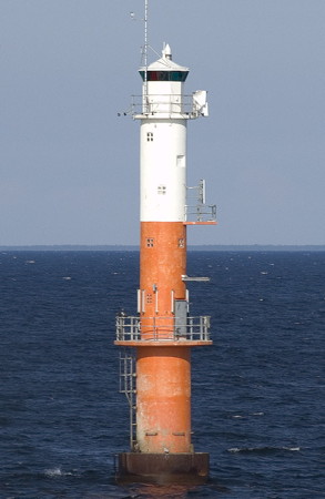
1968. Active; focal plane 20 m (66 ft); two long (2 s) flashes every 15 s, white, red or green depending on direction. 21 m (69 ft) round cylindrical concrete tower with lantern and gallery. Upper half of the lighthouse white, lower half orange. Teemu Vehkaoja's photo is at right, a wintry photo shows the lighthouse in silhouette, Trabas has a distant view, and Bing has a satellite view. Located on a small island about 5 km (3 mi) south of Holmsund and 12 km (7.5 mi) south of Umeå. Accessible only by boat. Site open, tower closed. SV-0860; Admiralty C5881; NGA 11140.
Gunvorsgrund
1971. Active; focal plane 22 m (72 ft); three flashes every 9 s, white, red or green depending on direction. 23 m (75 ft) round cylindrical concrete tower with lantern and gallery, upper half painted black and lower half white. The light is not shown in Google's satellite view. Located in the Gulf of Bothnia about 25 km (15 mi) southeast of Umeå. Accessible only by boat. Site open, tower closed. ARLHS SWE-165; SV-0840; Admiralty C5880; NGA 11132.

Nordmaling Lighthouses
Lögaren
1966. Inactive since 2018. 19.5 m (64 ft) round cylindrical concrete tower with lantern and gallery, upper half painted white and lower half black. MarineTraffic.com has Mikael Molin's photos and Bing has a satellite view. Located in the Gulf of Bothnia about 5 km (3 mi) southeast of Hörnefors. Accessible only by boat. Site open, tower closed. ARLHS SWE-265; ex-SV-0978; ex-Admiralty C5903; ex-NGA 11058.
Bonden
1913. Active; focal plane 35 m (115 ft); flash every 6 s, white, red or green depending on direction. 20 m (66 ft) cylindrical tower, upper half round and lower half square, with lantern and gallery. Upper half of lighthouse painted black, lower half white; lantern painted white. Marinas.com has aerial photos but Bing has only a fuzzy satellite view of the reef. Located on a small island about 11 km (7 mi) southeast of Norrbyn; the island, a nature preserve, is a favorite destination for sea kayakers. Accessible only by boat. Site open, tower closed. ARLHS SWE-101; SV-1042; Admiralty C5920; NGA 11056.
Sydostbrotten
1963 (lightship station established 1862). Active; focal plane 34 m (112 ft); three long (2.5 s) white flashes every 20 s. 34 m (112 ft) round cylindrical concrete tower with three galleries and a helipad on top, centered on a round 2-story concrete crew building. Lighthouse painted red with two horizontal black bands. Marinas.com has aerial photos but the lighthouse is not shown in Google's satellite view. Located about 20 km (13 mi) out in the Gulf of Bothnia and 30 km (19 mi) south of Umeå. Accessible only by boat. Site open, tower closed. ARLHS SWE-068; SV-1048; Admiralty C5923; NGA 11044.
Vaktarens Fyr
Väktaren Light, July 2009
photo copyright Teemu Vehkaoja; used by permission
Norbyskär
1943. Active; focal plane 5 m (17 ft); white, red or green light, depending on direction, 2 s on, 2 s off. 6 m (21 ft) round cylindrical concrete tower with lantern and gallery, painted white. Trabas has a photo, Hartmann has a page for the lighthouse, and Google has a satellite view. This lighthouse was originally the front light of a range; apparently the rear light deos not survive. Located on a skerry about 2.5 km (1.5 mi) south of Norrbyn. Accessible only by boat. Site open, tower closed. SV-1009; Admiralty C5910; NGA 11068.
Norra Långrogrundet
1962. Active; focal plane 18 m (59 ft); two flashes every 6 s, white, red or green depending on direction. 22 m (72 ft) round cylindrical concrete tower with lantern and gallery, painted with black and white horizontal bands. Marinas.com has aerial photos but the light is not shown in Google's satellite view. Located in the Gulf of Bothnia about 16 km (10 mi) southeast of Nordmaling. Accessible only by boat. Site open, tower closed. ARLHS SWE-294; SV-1053; Admiralty C5925; NGA 11004.
Storbåden
1890. Active; focal plane 17 m (56 ft); three flashes every 12 s, white, red or green depending on direction. 16 m (52 ft) round tower, painted white with a black horizontal band. Hartmann's page has a distant view and Google has a satellite view. Located on a small island in the center of the entrance to the bay leading to Nordmaling, about 15 km (9 mi) southeast of the town. Accessible only by boat. Site status unknown. ARLHS SWE-373; SV-1059; Admiralty C5928; NGA 10996.
Kyrkhälludden (2)
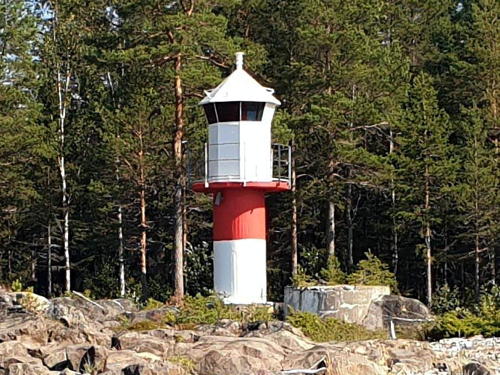
1968 (station established 1890). Active; focal plane 8 m (26 ft); white, red or green light, depending on direction, 1.5 s on, 1.5 s off. 7.5 m (25 ft) round cylindrical concrete tower with lantern and gallery, painted white with a red horizontal band below the gallery. SFA has a page with the photo at right (notice the foundation of the first lighthouse next to the present one). Trabas also has a photo and Google has an indistinct satellite view. Located on a promontory about 12 km (7.5 mi) southeast of Nordmaling. Site status unknown. SV-1080; Admiralty C5938; NGA 11020.
Vallinsgrundet (2)
1982 (station established 1972). Active; focal plane 19 m (62 ft); one long white flash every 12 s. 20 m (66 ft) round tower; lower portion of the tower painted red, upper portion and lantern painted white. The tower is not seen in Bing's satellite view. NGA misspells the name as Villinsgrundet. The original lighthouse was knocked over by ice in 1979. Located about 10 km (6 mi) south of Nordmaling (it's not clear if this location is in Västerbotten or in neighboring Västernorrland). Accessible only by boat. Site open, tower closed. SV-1055; Admiralty C5925.4; NGA 11000.

Kyrkhälludden Light, Robertsfors, August 2019
SFA Creative Commons photo by Tomas Berglund

Information available on lost lighthouses:

Notable faux lighthouses:

Adjoining pages: North: Northern Bothnia | South: Västernorrland

Return to the Lighthouse Directory index | Ratings key

Posted August 20, 2007. Checked and revised November 6, 2023. Lighthouses: 35. Site copyright 2023 Russ Rowlett and the University of North Carolina at Chapel Hill.