Though the fight for Tulagi was intense, that for the tiny islands of Gavutu and Tanambogo a few miles to the east was much more so. Joined by a narrow causeway, these two small spots of land had been developed before the war as a Royal Australian Air Force seaplane base. After they took the Southern Solomons in early May 1942, the Japanese continued that use, and had over five hundred men (or perhaps as many as a thousand) there, along with several four-engined patrol seaplanes and single-engined floatplane fighters when dawn broke on 7 August. Shortly afterwards, these aircraft had all been destroyed by U.S. carrier planes. The islands' occupants, a mixture of aviation personnel, construction troops and Special Naval Landing Force "marines" now confronted their fate as infantrymen.
Gavutu and Tanambogo gave them good defensive positions. Each island was dominated by a large hill, while buildings and entrenchments provided cover for Japanese machine guns and small artillery pieces. A brief pre-landing bombardment did little to reduce the defenses, so casualties were serious when U.S. Marines came ashore on Gavutu's northeastern side at about noon on August Seventh. Fighting continued on that island for the rest of the day, through the night and into the Eighth before Gavutu was reasonably secure. Meanwhile, Marine reserves had been called over from Guadalcanal, where they were not required, to Tulagi and Gavutu-Tanambogo, which needed them badly.
A small Marine attack on Tanambogo had failed during the evening of the 7th, and that island was still Japanese well into the following day. During the morning fresh Marines arrived on Gavutu to help complete the fight there. After a heavy bombardment by Navy ships, landings began on Tanambogo, led by a pair of tanks, and by nightfall the island was basically in American hands. Again, as on Tulagi, "mopping up" of well-dug-in Japanese continued for some time afterwards, a pattern that would become all too familiar as war swept across the Pacific during the next three years. The cost of taking Gavutu and Tanambogo was seventy Marine lives. As on Tulagi, there were few Japanese survivors.
This page features all the views we have related to the
conquest of Tanambogo and Gavutu Islands, near Tulagi, during
the first part of the Guadalcanal Campaign.
For other views related to the initial phase of the Guadalcanal
Campaign, see:
| If you want higher resolution reproductions than the Online Library's digital images, see: "How to Obtain Photographic Reproductions." |
Click on the small photograph to prompt a larger view of the same image.
|
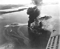
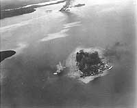
Photo #: 80-G-11899 Guadalcanal-Tulagi Landings, 7-9 August 1942 Japanese facilities burning on Tanambogo Island, east of Tulagi, on 7 August 1942, the invasion's first day. This view looks about ESE, with Gavutu Island to the right, connected to Tanambogo by a causeway. Small island to the left is Gaomi. The Florida Islands are in the distance. Photographed from an SBD aircraft based on one of the supporting U.S. aircraft carriers. Official U.S. Navy Photograph, now in the collections of the National Archives. Online Image: 77KB; 740 x 630 pixels Reproductions of this image may also be available through the National Archives photographic reproduction system. |
 |
|
Photo #: NH 97747 Guadalcanal-Tulagi Operation, August 1942 Tanambogo Island under bombardment by Allied ships and U.S. carrier aircraft on 7 August 1942. Causeway links Tanambogo with Gavutu Island, part of which is visible in the lower left. Photographed from a Navy plane, this view looks about northwest. The original photograph came from Rear Admiral Samuel Eliot Morison's World War II history project working files. U.S. Naval Historical Center Photograph. Online Image: 87KB; 690 x 650 pixels |
 |
|
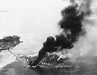
Photo #: 80-G-19223 Guadalcanal-Tulagi Landings, 7-9 August 1942 Fires burning among Japanese facilities and seaplanes on Tanambogo Island, east of Tulagi, on the invasion's first day, 7 August 1942. This view looks about SSW, with Gavutu Island to the left, connected to Tanambogo by a causeway. Official U.S. Navy Photograph, now in the collections of the National Archives. Online Image: 73KB; 740 x 595 pixels Reproductions of this image may also be available through the National Archives photographic reproduction system. |
 |
|
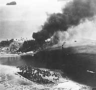
Photo #: NH 97746 Guadalcanal-Tulagi Operation, August 1942 Tanambogo Island during the bombardment by Allied ships and U.S. carrier aircraft on 7 August 1942, the day U.S. Marines landed on adjacent Gavutu Island. The small island in the foreground is Gaomi. Photographed from a Navy plane, this view looks toward the west. The original photograph came from Rear Admiral Samuel Eliot Morison's World War II history project working files. U.S. Naval Historical Center Photograph. Online Image: 87KB; 690 x 675 pixels |
 |
|
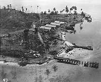
Photo #: 80-G-16311 Guadalcanal-Tulagi Landings, 7-9 August 1942 Wrecked facilities and aircraft at the Japanese seaplane base on Tanambogo Island, east of Tulagi. Photo is dated 8 August 1942 and was probably taken shortly before U.S. Marines captured the island. This view looks about west, with a burned-out pier in the foreground, fuel drums piled to the left and the wreckage of a seaplane among the trees in the center. The buildings are probably left over from the island's days as a Royal Australian Air Force facility. Official U.S. Navy Photograph, now in the collections of the National Archives. Online Image: 124KB; 740 x 625 pixels Reproductions of this image may also be available through the National Archives photographic reproduction system. |
 |
|
Photo #: NH 97745 Guadalcanal-Tulagi Operation, August 1942 Makambo Island, inside Tulagi harbor just north of Tulagi Island, under bombardment by Allied ships and U.S. carrier aircraft on 7 August 1942, the day U.S. Marines landed on Tulagi. A pattern of four shells has just landed in the water nearby and fires are burning ashore. Photographed from a Navy plane, this view looks toward the ESE, with Tanambogo, Gavutu and Gaomi Islands in the distance. Smoke is rising from Tanambogo. The original photograph came from Rear Admiral Samuel Eliot Morison's World War II history project working files. U.S. Naval Historical Center Photograph. Online Image: 72KB; 740 x 615 pixels |
 |
|
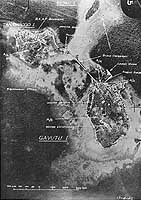
Photo #: NH 97765 Tanambogo and Gavutu Seaplane Base, Solomon Islands Fine-screen halftone reproduction of an annotated vertical aerial photograph, apparently prepared on 17 April 1942, while the base was still in use by the Royal Australian Air Force. Seized by the Japanese in early May, these islands were captured by U.S. Marines on 7-8 August 1942. The small island in the upper right center is Gaomi. The original photograph came from the illustrations package for Rear Admiral Samuel Eliot Morison "History of United States Naval Operations in World War II", volume IV (originally published opposite page 289). U.S. Naval Historical Center Photograph. Online Image: 170KB; 520 x 765 pixels |
 |
|
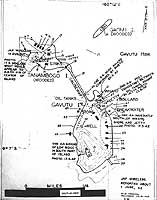
Photo #: NH 97748 Tanambogo, Gavutu and Gaomi Islands, near Tulagi Chart prepared for use during the invasion of the Guadalcanal and Tulagi area. It is dated 21 July 1942, about two weeks before the landings. See Photo # NH 97748 (complete caption) for a key to the numbered features. The original photograph came from Rear Admiral Samuel Eliot Morison's World War II history project working files. U.S. Naval Historical Center Photograph. Online Image: 104KB; 580 x 765 pixels |
 |
For other views related to the initial phase of the Guadalcanal
Campaign, see:
| If you want higher resolution reproductions than the Online Library's digital images, see: "How to Obtain Photographic Reproductions." |
Page made 27 January 2002