By May 1940, when the main part of the United States Fleet was transferred there from the west coast, Pearl Harbor had long been under development as a major naval base. Its Navy Yard had a dry dock capable of holding the largest warships, a marine railway for smaller ones, and an industrial plant for repairing and maintaining these ships. There were abundant mooring and docking locations for ships, including a berthing area along the eastern side of Ford Island that was commonly called "Battleship Row". Ford Island, dominating the center of Pearl Harbor, held a Naval Air Station for combat landplanes and patrol seaplanes. Across Southeast Loch from the Navy Yard was a submarine base and nearby was a large "farm" of fuel oil tanks. The base also included a Naval Hospital and other facilities.
This was still not nearly enough to support the Fleet. Pearl Harbor's area was limited, preventing the dispersal of its warships, and its opening to the sea was but a single narrow channel. Both of these elements were clearly dangerous from a security perspective. The base's supply and industrial capacity was too small to meet the Fleet's needs, and transportation from the west coast was slow and of insufficient carrying capacity. There were not enough tugs and other services to keep the Fleet operational and in good fighting practice. Housing and recreational facilities for the Fleet's thousands of Sailors and Marines were grossly inadequate for men who were to be long separated from their families. Nearby Honolulu was oversaturated with Navy and Army personnel, and its citizens, none-too-happy about the influx, did not welcome the new arrivals. Accordingly, Fleet readiness was handicapped, its security was well below optimum levels, and its morale was impared.
During 1940-41, construction of new facilities was undertaken to address some of these problems. The supply depot, on a peninsula across the channel from "Battleship Row", was greatly expanded, other locations were developed for basing aircraft, new permanent drydocks were begun, a floating drydock was brought over from the mainland, and many other improvements were prepared or started. The Army and Army Air Corps, responsible for the defense of Hawaii and the Pearl Harbor base, also built new facilities and brought in more forces. However, other deficiencies were either inherent to the physical location or simply could not be corrected within the limits of time, competing requirements and available resources. These had to be borne as best they could.
This page features aerial photographs of Pearl Harbor, taken
during 1940-1941, prior to the outbreak of war with Japan.
For additional aerial views of Pearl Harbor in 1940-1941,
showing individual components of the base, see:
For views of the Japanese attack on Pearl Harbor, see:
| If you want higher resolution reproductions than the Online Library's digital images, see: "How to Obtain Photographic Reproductions." |
Click on the small photograph to prompt a larger view of the same image.
|
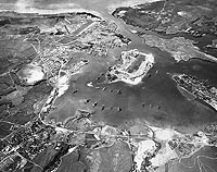
Photo #: NH 54301 Pearl Harbor, Oahu, Hawaii Fine-screen halftone reproduction of a photograph taken circa 1940, showing battleships moored alongside Ford Island (center and left), with cruisers and other ships also present. The Navy Yard is at the left and the Supply Base and Submarine Base are at the center-right and right. This view looks toward the northwest. U.S. Naval History and Heritage Command Photograph. Online Image: 196KB; 740 x 585 pixels |
 |
|
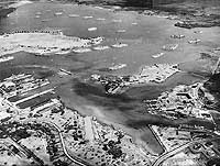
Photo #: 80-G-411120 Pearl Harbor, Oahu, Hawaii Aerial photograph from 2500 feet altitude, looking southward, showing the U.S. Fleet moored in the harbor on 3 May 1940. This was soon after the conclusion of Fleet Problem XXI and four days before word was received that the Fleet was to be retained in Hawaiian waters. There are eight battleships and the carrier Yorktown (CV-5) tied up by Ford Island, in the center of the harbor. Two more battleships and many cruisers, destroyers and other Navy ships also present, most of them moored in groups in East Loch, in the foreground. A few of the destroyers are wearing experimental dark camouflage paint. In the distance, center, is Hickam Army Air Field. The Pearl Harbor entrance channel is in the right distance. Official U.S. Navy Photograph, now in the collections of the National Archives. Online Image: 83KB; 740 x 600 pixels Reproductions of this image may also be available through the National Archives photographic reproduction system. |
 |
|
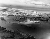
Photo #: 80-G-411119 Pearl Harbor, Oahu, Hawaii Aerial photograph from 4000 feet altitude, looking southwestward, with the U.S. Fleet at moorings. Taken on 3 May 1940, after the conclusion of Fleet Problem XXI. This was four days before word was received that the Fleet was to be retained in Hawaiian waters. There are eight battleships and the carrier Yorktown (CV-5) tied up along the near side of Ford Island, in the center of the harbor. Two more battleships and many cruisers, destroyers and other Navy ships also present. Official U.S. Navy Photograph, now in the collections of the National Archives. Online Image: 89KB; 740 x 605 pixels Reproductions of this image may also be available through the National Archives photographic reproduction system. |
 |
|
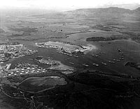
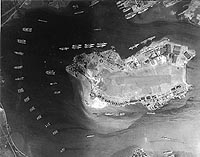
Photo #: 80-G-411117 Pearl Harbor, Oahu, Hawaii Vertical aerial photograph from 17,200 feet altitude, looking directly down on East Loch and on the Fleet Air Base on Ford Island. Taken on 3 May 1940, after the conclusion of Fleet Problem XXI, and just prior to the 7 May receipt of word that the Fleet was to be retained in Hawaiian waters. There are eight battleships and the carrier Yorktown (CV-5) tied up along the island's southeastern side (toward the top), with two more battleships alongside 1010 dock at top right center. Two light cruisers and two destroyers are among the ships moored along Ford Island's northwestern side. Seventeen other cruisers and over thirty destroyers are also visible, mainly in East Loch. At the seaplane base, at the southern (top right) tip of Ford Island, are at least 38 PBY patrol planes. Official U.S. Navy Photograph, now in the collections of the National Archives. Online Image: 104KB; 740 x 605 pixels Reproductions of this image may also be available through the National Archives photographic reproduction system. |
 |
|
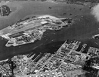
Photo #: 80-G-451185 Pearl Harbor, Oahu, Hawaii Aerial view, looking north, with the Navy Yard in the foreground, 7 January 1941. Ford Island Naval Air Station is in the center-left, and Pearl City is in the extreme upper left. There are about 27 PBY patrol planes at the seaplane base, at the lower left point of Ford Island. Aircraft carrier moored on the far side of Ford Island is USS Lexington CV-2). Other identifiable ships include USS Wright (AV-1), USS Curtiss (AV-4), USS Oglala (CM-4) and USS Medusa (AR-1). Official U.S. Navy Photograph, now in the collections of the National Archives. Online Image: 149KB; 740 x 600 pixels Reproductions of this image may also be available through the National Archives photographic reproduction system. |
 |
|
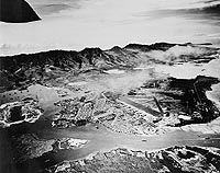
Photo #: NH 89041 Pearl Harbor, Oahu, Hawaii Aerial photograph, looking east, with Hickam Army Air Field in center and Honolulu beyond, 13 October 1941. The Pearl Harbor Navy Yard is in the left-center, and Ford Island is at the far left. Courtesy of the U.S. Naval Institute, Annapolis, Maryland. U.S. Naval History and Heritage Command Photograph. Online Image: 137KB; 740 x 610 pixels |
 |
|
Photo #: 80-G-182874 Pearl Harbor, Oahu, Hawaii Aerial view of the Naval Operating Base, Pearl Harbor, looking southwest on 30 October 1941. Ford Island Naval Air Station is in the center, with the Pearl Harbor Navy Yard just beyond it, across the channel. The airfield in the upper left-center is the Army's Hickam Field. Official U.S. Navy Photograph, now in the collections of the National Archives. Online Image: 171KB; 740 x 610 pixels Reproductions of this image may also be available through the National Archives photographic reproduction system. |
 |
|
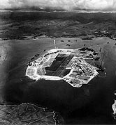
Photo #: 80-G-279375 Pearl Harbor, Oahu, Hawaii Aerial photograph of Ford Island, looking about NNE, taken 10 October 1941. The Naval Air Station occupies most of the island, with the seaplane base on the point at the near right. There are about twenty PBY patrol planes parked there. USS Enterprise (CV-6), USS Curtiss (AV-4) and two battleships are tied up along Ford Island's southeastern side, to the right. The bright line, just above Ford Island in the center, points to the north. Aiea is on the far shore in the upper right. Official U.S. Navy Photograph, now in the collections of the National Archives. Online Image: 99KB; 600 x 675 pixels Reproductions of this image may also be available through the National Archives photographic reproduction system. |
 |
|
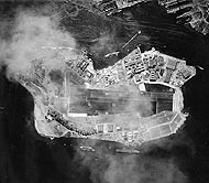
Photo #: 80-G-279370 Pearl Harbor, Oahu, Hawaii Vertical aerial photograph of Ford Island, taken 22 October 1941. USS Saratoga (CV-3) is moored in the lower right center, on Ford Island's northwestern side. Three battleships and an oiler are moored along "Battleship Row", on the island's southeastern side. Another battleship is alongside 1010 dock, in the top center. In the extreme top right corner is the Navy Yard's Drydock Number Two, under construction, and the floating drydock YFD-2. Approximately 22 PBY patrol planes are parked at the Naval Air Station's seaplane base, on the upper right point of Ford Island. The bright diagonal line, just above Ford Island in the right center, points (down and left) to the north. Official U.S. Navy Photograph, now in the collections of the National Archives. Online Image: 115KB; 700 x 630 pixels Reproductions of this image may also be available through the National Archives photographic reproduction system. |
 |
|
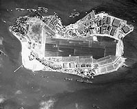
Photo #: 80-G-279385 Pearl Harbor, Oahu, Hawaii Vertical aerial photograph of Ford Island, taken 10 November 1941, with five battleships tied up along "Battleship Row" at the top of the image. USS Lexington (CV-2), a seaplane tender and a light cruiser are moored on the island's other (northwestern) side. Approximately 21 PBY patrol planes are parked at the Naval Air Station's seaplane base, in the upper right. The bright diagonal line, at the lower left end of Ford Island, points to the north. Official U.S. Navy Photograph, now in the collections of the National Archives. Online Image: 113KB; 740 x 615 pixels Reproductions of this image may also be available through the National Archives photographic reproduction system. |
 |
For additional aerial views of Pearl Harbor in 1940-1941,
showing individual components of the base, see:
For views of the Japanese attack on Pearl Harbor, see:
NOTES:
| If you want higher resolution reproductions than the Online Library's digital images, see: "How to Obtain Photographic Reproductions." |
Page made 15 October 2000
Coding updated 19 April 2009