Photo #: NH 59260
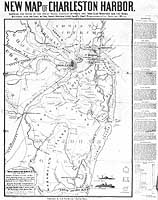
"New Map of Charleston Harbor"
"Showing the Scene of the Great Naval Contest between the
Iron Clad Monitors and the Rebel Batteries, also the Lines of
Fire, Forts, Obstructions, Princ'l. Plantations, & E.t.c."
Lithograph by J. Mayer & Co., published in 1863 by G.W. Tomlinson,
Boston, Massachusetts. The print features, in its lower right,
small drawings of a monitor (labeled "The Ericsson Devil"),
USS Keokuk, Fort Sumter, Fort Moultrie and Castle Pinckney.
Along its right side are descriptions of Charleston's defenses.
Copied from The Library of Congress: "Civil War Maps Annotated",
N.R. 376.
U.S. Naval Historical Center Photograph.
Online Image: 344KB; 945 x 1225
pixels |
 |