Return to Naval Historical Center home page. Return to Online Library listing

DEPARTMENT OF THE NAVY -- NAVAL HISTORICAL CENTER
805 KIDDER BREESE SE -- WASHINGTON NAVY YARD
WASHINGTON DC 20374-5060

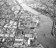
Photo # NH 90707:  Washington Navy Yard, D.C., aerial view looking east, circa 1960

Online Library of Selected Images:
-- PLACES -- UNITED STATES -- WASHINGTON, D.C.

Washington Navy Yard, Naval Gun Factory and Naval Weapons Plant --
Overall Views -- 1940-1961

The World War II years brought on the Navy Yard's final great expansion. Two additional land parcels took its western boundary all the way to First Street. Several more large buildings were constructed, most notably in the northeastern and western parts of the facility, to allow the Yard to keep up with wartime demands for weapons production as well as scientific and engineering development.

These technological activities increasingly became the Yard's main functions after the War. Naval guns continued to be built, but these were nearly all smaller weapons, rapid-firing five-inch and three-inch types optimized for anti-aircraft purposes. Countering faster aircraft and submarines, and a generally more-complex tactical environment, required ever-more-capable radar, sonar, weapons directors, and other optical and electronic devices. Existing Naval Gun Factory shops were modified, and new ones established, to develop and produce this new equipment.

During the 1950s, guns began to be displaced by guided missiles aboard the Navy's ships, and the Gun Factory took up the manufacture of these weapons, and especially of their launchers. Late in the decade, this change in ordnance technology gave the Yard a new name: the Naval Weapons Plant. However, by this time its days as an industrial site were numbered. Weapon and electronics work was now mainly going to private enterprise and Government operated facilties were being phased out. The Naval Weapons Plant's assigned production work was completed in 1961, and the next two years saw its disestablishment and the beginning of the Navy Yard's conversion to other purposes. Washington, D.C., never much of an industrial town, had lost its largest manufacturing operation.

This page features overall views of the Washington Navy Yard taken from 1940 into the early 1960s.

For links to other overall views of the Washington Navy Yard, see:

  • Washington Navy Yard -- Overall Views -- 19th Century.

    If you want higher resolution reproductions than the Online Library's digital images, see: "How to Obtain Photographic Reproductions."

    Click on the small photograph to prompt a larger view of the same image.

    Photo #: NH 97842

    Washington, D.C.


    Photograph of the Southeastern and Southwestern quadrants of the city, looking about west from above the Anacostia district, circa 1944-45.
    The Sousa (Pennsylvania Avenue) bridge across the Anacostia River is in the lower right and the Eleventh Street Bridge is in the lower center, with the Washington Navy Yard (Naval Gun Factory) eastern boundary next to Eleventh Street, in the center of the view.
    Visible in the distance are the Pentagon (top left); the Jefferson and Lincoln Memorials and the Washington Monument (top center) and the U.S. Capitol (far right). Many World War II temporary office buildings are also visible.

    Collection of Arthur C. Clark.

    U.S. Naval Historical Center Photograph.

    Online Image: 173KB; 645 x 675 pixels

     
    Photo #: NH 82601

    Potomac River Flood, October 1942


    View of the Anacostia River waterfront, looking southeasterly from over the Washington Navy Yard, showing flood conditions. The 11th Street Bridge is at left, with the southeastern portion of the Navy Yard in the lower part of the view and part of the Anacostia Naval Station on the opposite side of the river.
    Ships in the river include USS Hartford (IX-13), in center; USS Dauntless (PG-63), tied up to one of the Navy Yard's piers at right; and USS Sequoia (AG-23), moored in the middle of the river at right.
    Note how far the flood waters have advanced up the Navy Yard's streets, well beyond Buildings # 1 and 76, in the lower right center.

    U.S. Naval Historical Center Photograph.

    Online Image: 120KB; 620 x 675 pixels

     
    Photo #: NH 82600

    Potomac River Flood, October 1942


    View of the Anacostia River waterfront, looking southeasterly near the 11th Street Bridge, showing flood conditions. The eastern end of the Washington Navy Yard is in the lower right.

    U.S. Naval Historical Center Photograph.

    Online Image: 111KB; 615 x 675 pixels

     
    Photo #: NH 91946

    Naval Gun Factory, Washington Navy Yard,
    District of Columbia


    View of the Navy Yard and its vicinity, looking east from approximately over South Capitol Street, circa 1946.
    M Street SE, the Yard's northern boundary, is at left. Half Street and First Street SE (the Yard's western boundary) are at the bottom of the photo.

    Courtesy of the U.S. Naval Institute Photo Collection, 1981.

    U.S. Naval Historical Center Photograph.

    Online Image: 157KB; 585 x 765 pixels

     
    Photo #: NH 91945

    Naval Gun Factory, Washington Navy Yard,
    District of Columbia


    View of the Navy Yard and its vicinity, looking westward from over Anacostia, circa 1947-1950.
    The Eleventh Street Bridge, across the Anacostia River, is in the center foreground. The South Capitol Street Bridge is under construction at left.

    Courtesy of the U.S. Naval Institute Photo Collection, 1981.

    U.S. Naval Historical Center Photograph.

    Online Image: 143KB; 740 x 595 pixels

     
    Photo #: NH 91948

    Washington, District of Columbia


    View looking east-north-easterly from over East Potomac Park, circa 1948.
    Fort McNair is in the foreground, with the Army War College at right and many World War II temporary office buildings on its eastern side. The Washington Navy Yard is in the middle, on the north side of the Anacostia River. Naval Air Station, Anacostia, is on the Anacostia River's south side, at the extreme right. The South Capitol Street Bridge is under construction in the right center.

    Courtesy of the U.S. Naval Institute Photo Collection, 1981.

    U.S. Naval Historical Center Photograph.

    Online Image: 141KB; 740 x 600 pixels

     
    Photo #: NH 91943

    Naval Gun Factory, Washington Navy Yard,
    District of Columbia


    View of the Navy Yard and its vicinity, looking north from over the Anacostia River, 1949.
    The Yard's eastern boundary, at Eleventh Street SE, is near the right side of the photo. Second Street SE is in the image's upper left, and M Street SE, the Yard's northern boundary, runs horizontally through the middle.

    U.S. Naval Historical Center Photograph.

    Online Image: 157KB; 740 x 605 pixels

     
    Photo #: NH 90707

    Washington Navy Yard, District of Columbia


    View of the Navy Yard and its vicinity, looking eastward from over the South Capitol Street area, circa 1960.
    The Yard's western edge, at First Street SE, is near the lower edge of the photo; its northern boundary, at M Street SE, is marked by the dark-colored street running nearly vertically in the left center. The Anacostia River runs diagonally from lower left to upper right center, crossed by the Eleventh Street Bridge (in center) and the Sousa Bridge (Pennsylvania Avenue) near the top.

    U.S. Naval Historical Center Photograph.

    Online Image: 169KB; 690 x 615 pixels


    For links to other overall views of the Washington Navy Yard, see:

  • Washington Navy Yard -- Overall Views -- 19th Century.


    If you want higher resolution reproductions than the Online Library's digital images, see: "How to Obtain Photographic Reproductions."


    Return to Naval Historical Center home page.

    Page made 17 February 2002