9. Navigating
If your lifeboat is without a navigator, these
directions are for you. There is nothing difficult
about them. They are as simple as the directions
for a child's game. But they will provide you
with the key to your own rescue.
Before leaving your home port, purchase a
U.S. Hydrographic Office "Pilot Chart" covering
the area of your ship's route. Pilot Charts
cost ten cents a sheet, and are obtainable at any
nautical store. If your are a soldier or sailor, and
consequently do not know your route or destination,
we suggest that you buy for sixty cents the
six sections taking in the entire world.
Disregard the printed statement that the chart
is not to be used for navigation. For your purposes
it is entirely adequate. During the nineteen
days in the Robin Moor lifeboat, Banigan daily
plotted his position on a Pilot Chart.
If you have no chart, and do not know of any
islands North or South of you, set your course
as close to due East or due West as the winds
will permit, and eventually you will sight land.
--62--
With a Pilot Chart and knowledge of your
approximate position, you can plot the track or
route you should take, simply by observing the
nearest point of land from you.
Whether the average winds are in your favor
can be readily seen by the wind roses on the
chart along your chosen track. The chart provides
adequate instructions regarding the wind roses.
If you are an untrained man, do not concern
yourself with the set of the current. Your guess
as to allowance will undoubtedly be out of proportion.
Obtain your true course -- the one you intend
to steer by -- in this simple manner:
Note the compass rose -- the circle on the chart
that is graduated from 0 to 360 degrees.
Take two stick or pieces of cardboard.
Lay one on the proposed track.
Lay the second stick across the center of the
compass rose parallel to the first stick. Use the
stick in the same way you would use a ruler.
Read off the course indicated by the stick on
the compass rose in the direction of the proposed track.
Note the lines of variation plainly indicated as
to the amount and direction, East or West.
Variation is the difference between the true
or geographical North and the magnetic North.
--63--
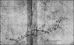
NOTE ON CHART (see opposite page)
On the opposite page is reproduced the
photograph
of a section of the Pilot Chart on which John J.
Banigan plotted the noon positions of his Robin
Moor lifeboat. The oblique line shows the robin
Moor's course and noon positions east of the Great
Circle track, from May 19th, 1941, until the vessel
was torpedoed and sunk by a Nazi U-boat on the
morning of May 21st, 0805 Greenwich time. The
jagged line, running from right to left, shows the
route of Banigan's lifeboat, from setting sail on May
22nd to 10:00 the night of June 8th, when the eleven
men were picked up by the Lloyd Brasileiro line
Osario, Lat. 0°46'N, Long. 37°37W. Note that the
boat was about 119 miles from St. Paul Rocks on
May 27th, when it reached the southernmost limit
of the NE trades. Note the two periods of doldrums -- calms -- from
May 29th to June 1st and from June
4th to June 6th. Note that no positions were plotted
for May 31st and June 3rd when overcast skies prevented
the taking of sights. These positions were
checked back in banigan's Work Book by Captain
W.L. Pereira of the Osario. Navigators attempting
to take sights in lifeboats have complained that they
were unable to find the horizon. These checked positions
offer documentary evidence that by standing on
a thwart, supported by crewmen and resting against
a makeshift rail, a mate should experience no great
difficulty in making use of his sextant.
--64--

Banigan's Pilot chart (Photograph by Edward V. Banigan)
--65--
But don't worry your head about what variation
is. Concern yourself merely with what you
have to do about it.
Variation represents an error which you must correct.
If it is stated on the Pilot Chart that the variation
is West -- add the amount of variation to
the course indicated by the stick on the compass
rose. If the variation is East -- subtract.
The answer is the course to steer.
So long as the sail is kept full, a lifeboat
rigged with a dipping lug sail will average between
3 to 4 knots in a moderate breeze. Gauging
your speed by this, and mindful of the
chart's scale of measurements, you can plot your
position day by day.
The scale of latitude is used for measuring distances.
You will find this scale on the right- and left-hand
sides of the chart. One degree equals 60
miles or minutes. The scale is graduated in 6
parts of 10 minutes each.
Always measure off distance near your parallel
of latitude.
The scale of longitude is graduated in the same
way as the scale of latitude. But never use the
scale of longitude to measure your distance.
When there is any shift in the wind which
may require a change in course, you should make
--66--
each change, if possible, in the general direction
of your proposed track.
We have made no attempt to teach the elements
of navigation, but we have presented a
working plan which will help you to reach land
or the steamer tracks where you have a chance of
being picked up.
--67--
Table of Contents
Previous Chapter (8) *
Next Chapter (10)

