Lighthouses of American Samoa

The Samoan Islands are an archipelago of Polynesia in the South Pacific Ocean. The islands were partitioned in 1900; the large western islands of 'Upolu and Savai'i were assigned to Germany and the smaller eastern islands to the United States. German Samoa, as it was called, was occupied by troops from New Zealand in 1914, early in World War I. Renamed Western Samoa, it remained under New Zealand administration until it became the Independent State of Samoa in 1962.

The eastern islands, American Samoa, continue as an unincorporated U.S. territory. Tutuila is the major island; there are four other islands and two coral atolls also in the territory. The capital and principal town is Pago Pago on Tutuila; it has a magnificent natural harbor, one of the best in the South Pacific. The population of the territory is about 50,000.

American Samoa has no traditional lighthouses but there are a small number of minor lightbeacons maintained by the U.S. Coast Guard Fourteenth District in Hawai'i. Information on these lights is scarce and photos are difficult to find. Special thanks to Elinor DeWire, author of The Field Guide to the Lighthouses of the Pacific Coast, for sharing information and historic Coast Guard photos from her files.

The Samoan phrase for a lighthouse is moli uila; motu is an island, aau is a reef, and uafu is a harbor.

Admiralty numbers are from volume K of the Admiralty List of Lights & Fog Signals. U.S. NGA List numbers are from Publication 111. USCG numbers are from Volume VI of the U.S. Coast Guard Light List. ARLHS does not list any lights in American Samoa.

General Sources
South Pacific Lighthouses
Photos taken in 2017 by Larry Myhre.
Online List of Lights - American Samoa
Photos by Rainer Arndt and Jim Smith posted by Alexander Trabas.
U.S. Coast Guard Navigation Center: Light Lists
The USCG Light List can be downloaded in pdf format.
Navionics Charts
Navigation chart for Tutuila.


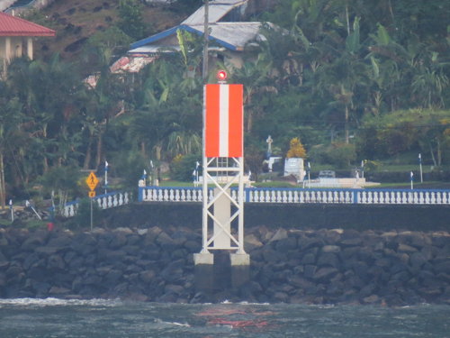
Range Front Light, Pago Pago, April 2017
Flickr Creative Commons photo by Larry Myhre

Aunu'u Lightbeacon
[Aunu'u Island (2?)]
Date unknown. Inactive since 2014. 7.5 m (25 ft) steel tower. No photo available and the small tower is not seen in Google's satellite view. Jenkins 1907 light list does not include this light but a 1922 light list describes a 4 m (13 ft) white square pyramidal tower. Aunu'u is a small volcanic island off the southeastern coast of Tutuila. The light, with a focal plane 83 m (272 ft), guided vessels as they round the eastern end of Tutuila en route to Pago Pago. Located on the steep northeast coast of Aunu'u. Site status unknown. ex-Admiralty K4588; ex-NGA 3084; ex-USCG 6-30175.

Tutuila Lightbeacons
* [Breakers Point (2?)]
Date unknown. Active; focal plane 58 m (190 ft); flash every 6 s, white or red depending on direction. 8 m (27 ft) post carrying a diamond-shaped daymark painted with black and white checkers. A small equipment cabinet is attached to the post. The photo at right shows a U.S. Coast Guard Aids to Navigation Team checking the light after the earthquake and tsunami that struck the islands in September 2009. A Coast Guard photo is at right, Myhre has a 2017 photo, and Trabas has Jim Smith's photo but the small tower is barely visible in Google's satellite view. This is the landfall light for Pago Pago. Jenkins 1907 light list does not include this light, but a 1922 light list describes a 5 m (16 ft) white square pyramidal tower. The light is close to communication towers and other facilities. Located on the promontory on the east side of the entrance to Pago Pago Harbor. Accessible by road but the entrance is unmarked. Site open, tower closed. Admiralty K4576; NGA 3088; USCG 6-30185.
* Pago Pago Range Front (4?)
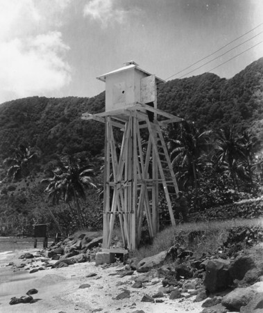
Date unknown (station established 1901). Active; focal plane 11 m (37 ft); quick-flashing red light, visible only on or close to the range line. 11 m (36 ft) square skeletal tower carrying a daymark colored red with a white vertical stripe. Myhre's photo is at the top of this page, he also has a photo showing both range lights, Trabas has Arndt's photo, and Google has a street view and an indistinct satellite view. The original range lights were described as "iron standards," a 1922 light list describes a 3.5 m (11 ft) white square pyramidal tower, and by 1947 the lights were shown from the wood towers seen below. Located at the water's edge on the east end of the Pago Pago waterfront. Site open, tower closed. Admiralty K4580; NGA 3092; USCG 6-30190.
Breakers Point Light
Breakers Point Light, 2009
U.S. Coast Guard photo courtesy of Elinor DeWire
[Pago Pago Range Rear (4?)]
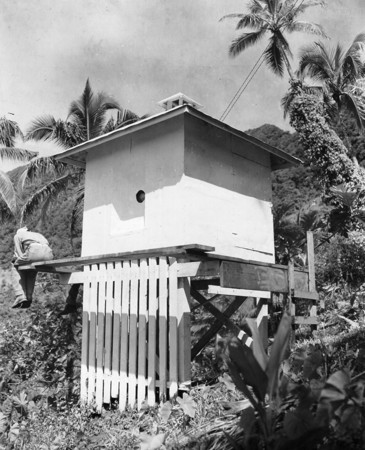
Date unknown (station established 1901). Active; focal plane 55.5 m (182 ft); red light, 3 s on, 3 s off, visible only on or close to the range line. 3 m (10 ft) square skeletal tower carrying a daymark colored red with a white vertical stripe. Myhre has a photo and Trabas has Arndt's photo, but the tower is not clearly identified in Google's satellite view. The "square structure" listed as of 1947 is seen below. Located on the mountainside 194 m (212 yd) northwest of the front light. Site status unknown. Admiralty K4580.1; NGA 3096; USCG 6-30195.
Tafuna (Pago Pago International Airport)
Date unknown. Active; focal plane about 30 m (98 ft), flashing light, alternately white and green. 15 m (49 ft) short mast atop a square cylindrical unpainted concrete tower. Trabas has Arndt's photo and Google has a street view and a satellite view. This is an aviation beacon but its placement makes it also a landfall light for the island. Located at the Pago Pago International Airport at Tafuna on the west side of the harbor entrance. Site and tower closed but the tower can be seen from nearby. Admiralty K4574.6.
Pago Pago Front Range Light
Range Front Light, Pago Pago, 1947
U.S. Coast Guard photo courtesy of Elinor DeWire
Pago Pago Rear Range Light
Range Rear Light, Pago Pago, 1947
U.S. Coast Guard photo courtesy of Elinor DeWire

Information available on lost lighthouses:

Notable faux lighthouses:

Adjoining pages: North: Kiribati | Southeast: Cook Islands | Southwest: Tonga | West: Samoa

Return to the Lighthouse Directory index | Ratings key

Posted April 30, 2014. Checked and revised October 11, 2023. Lighthouses: 2. Site copyright 2023 Russ Rowlett and the University of North Carolina at Chapel Hill.