Lighthouses of Mexico: Southwestern Baja California

Mexico, officially the United Mexican States (Estados Unidos Mexicanos or EUM), is the second largest country of Latin America and the largest Spanish-speaking nation in the world. With an east coast on the Gulf of Mexico and Caribbean Sea and a long west coast on the Pacific Ocean it has by far the longest coastline in Latin America and, as a result, the largest number of lighthouses.

The Baja California region of Mexico is a peninsula more than 1300 km (800 miles) long, stretching south from the U.S. border at Tijuana to the resorts of Cabo San Lucas. "Baja," as it is usually called, separates the Pacific on the west from the Sea of Cortés (Gulf of California) on the east. The west coast is popular with surfers and the east coast attracts sea kayakers and ecotourists. Many visitors arrive in Baja California by air or cruise ship, but there are also paved highways running the length of the peninsula. Federal Highway 1, the Carretera Transpeninsular, runs 1711 km (1063 mi) from Tijuana at the U.S. border to Cabo San Lucas

Mexico is a federal union of 31 states (estados) plus the capital district and the states are subdivided into municipalities (municipios). The state of Baja California occupies the northern half of the peninsula, while the state of Baja California Sur occupies the southern half, the border between the two states being at latitude 28° north. This page includes the lighthouses of the south and west coasts of Baja California Sur.

Many of the lighthouses of Baja California Sur are in remote areas and are seldom visited. Additional information and photos would certainly be welcome. Because of the rugged topography of the peninsula most of the lighthouses are short towers located at the tops of bluffs or ridges overlooking the sea.

Mexican lighthouses are managed by the Port Captains and Maritime Affairs Unit (Unidad de Capitanías de Puerto y Asuntos Marítimos, UNICAPAM). Many of the larger light stations are staffed by resident civilian keepers.

In Spanish the word for a lighthouse is faro, baliza is a beacon, isla is an island, cabo is a cape, punta is a promontory or point of land, péñon is a rock, arrecife is a reef, bahía is a bay, ría is an estuary or inlet, estrecho is a strait, río is a river, and puerto is a port or harbor.

ARLHS numbers are from the ARLHS World List of Lights. CF numbers are from the Mexican Cuaderno de Faros (Handbook of Lighthouses). Admiralty numbers are from volume G of the Admiralty List of Lights & Fog Signals. U.S. NGA numbers are from Publication 111.

General Sources
Online List of Lights - Mexico Pacific
Photos by various photographers posted by Alexander Trabas.
Lighthouses in Mexico
Photos by various photographers available from Wikimedia.
World of Lighthouses - Mexico
Photos by various photographers available from Lightphotos.net.
Viaje por las Islas del Pacífico de Baja California
Posted by Elizabeth Vargas, a blog of a March 2009 tour of some of the islands with stops at several remote lighthouses.
Mexico Lighthouses
Photos posted by Larry Myhre on Flickr.com.
Navionics Charts
Navigational chart for Baja California.


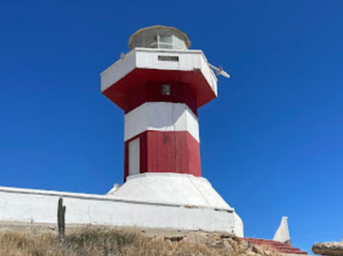
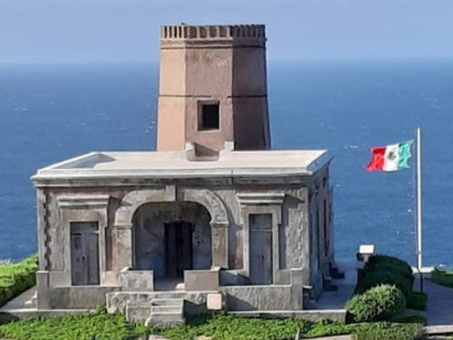
Old Cabo Falso Light, Los Cabos, March 2016
photo copyright John McFadden; used by permission

New Cabo Falso Light
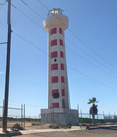
New Cabo Falso Light, Los Cabos, April 2010
photo copyright Hilari and Jim Seery; used by permission

Los Cabos Municipality Lighthouses

The municipality of Los Cabos (The Capes) includes the region at the southern tip of Baja California, including the resort cities of Cabo San Lucas and San José del Cabo and the 32 km (20 mi) corridor of resorts and beaches between the two towns.
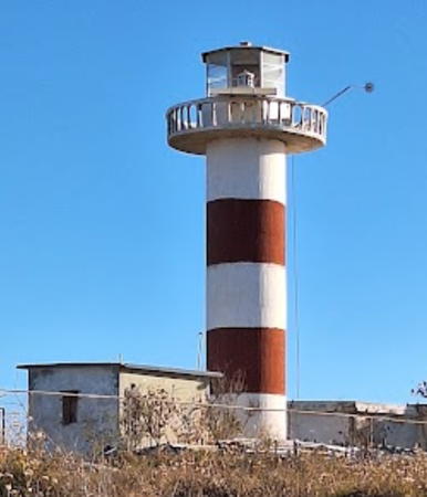
Punta Arena de la Rivera (1)
Date unknown. Inactive. 12 m (39 ft) strongly conical concrete tower with double gallery, formerly painted with black and white horizontal bands. Abandoned 1-story masonry keeper's house. The abandoned tower is at the left in Capt. Peter's photo at right. Google has a satellite view. The site is reported to be on a military reservation. Located several miles south of La Ribera and 18 km (11 mi) north of Cabo Pulma at the north end of the area known as the East Cape. Site and tower closed. ARLHS MEX-123.
Punta Arena de la Rivera (2)
Date unknown. Active; focal plane 20 m (66 ft); four white flashes every 16 s. 12 m (39 ft) round cylindrical concrete tower with gallery, painted with black and white horizontal bands. Trabas has Capt. Peter's photo (also seen at right), Joseph Flores has a 2019 photo, and the new lighthouse stands next to the old one in Google's satellite view. Site and tower closed. CF-03-340; Admiralty G3580; NGA 14568.
Boca del Tule
Date unknown. Active; focal plane 18 m (59 ft); three white flashes every 12 s. 12 m (39 ft) square skeletal tower with gallery, painted white and carrying a slatted daymark colored with red and white horizontal bands. Trabas has Capt. Peter's photo and Google has an indistinct satellite view. Located on the East Cape coast about 65 km (40 mi) northwest of San José del Cabo. Site open, tower closed. CF-03-335; Admiralty G3582; NGA 14564.
* San José del Cabo
Date unknown (station established 1907). Active; focal plane 36 m (118 ft); two white flashes every 10 s. 10 m (33 ft) round cylindrical concrete tower with gallery, painted with red and white horizontal bands. 1-story masonry keeper's house. Laurie Pitman has a 2016 closeup photo, Deana Conner has a 2017 photo, Trabas has Capt. Peter's distant view, and Google has a satellite view and a distant street view. San José del Cabo is a resort town about 40 km (25 mi) northwest of Cabo San Lucas. Located at the east end of Avenida Delfin. Site appears to be open, tower closed. ARLHS MEX-074; CF-03-330; Admiralty G3584; NGA 14560.
* Cabeza Ballena (El Encanto) (2)
Date unknown. Active; focal plane 40 m (131 ft); three white flashes every 12 . 10 m (33 ft) round cylindrical white concrete tower with gallery painted with red and white horizontal bands.. Trabas has Capt. Peter's photo, Felipe Villanueva has a 2023 photo, and Google has a satellite view. Myhre has a view from the sea of the earlier, all white, lighthouse. The name means "whale head," probably referring to the appearance of the headland from the sea. Located on a promontory about 8 km (5 mi) east of the Cabo San Lucas beachfront. Accessible by 4WD. Site open, tower closed. CF-03-325; Admiralty G3585; NGA 14556.

Punta Arena de la Rivera Light, Los Cabos
photo copyright Capt. Peter Mosselberger; used by permission
* Cabo San Lucas North Breakwater
Date unknown. Active; focal plane about 21 m (69 ft); red flash every 5 s. Approx. 19 m (62 ft) square pyramidal skeletal tower with gallery, painted red (formerly white) and mounted on a square pyramidal concrete base. Myhre has a 2012 photo, Trabas has Eckhard Meyer's closeup photo, Nick Sperounes has a 2017 street view, and Google has a satellite view. The listed focal plane is 16 m (52 ft), but in the photos we see that the light has been moved to the top of a mast mounted on the gallery. Located at the end of the short north jetty at the entrance to the yacht harbor of Cabo San Lucas. Accessible by walking the mole. Site open, tower closed. CF-03-310; Admiralty G3589.1; NGA 14549.
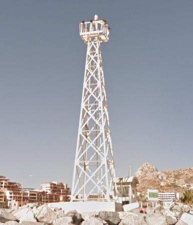
* Cabo San Lucas South Breakwater
Date unknown. Active; focal plane 16 m (52 ft); green flash every 5 s. 14 m (46 ft) square pyramidal skeletal tower with gallery, painted white. A 1-story equipment shelter in enclosed in the base of the tower. Myhre's photo is at right, Trabas has Hendrik Martin Porath's photo, Dwayne Volk has a 2017 street view, and Google has a satellite view. Located at the end of the short south jetty at the entrance to the yacht harbor of Cabo San Lucas. Accessible by walking the mole. Site open, tower closed. CF-03-315; Admiralty G3589.2; NGA 14550.
* Cabo San Lucas Range Front
Date unknown. Active; focal plane 26 m (85 ft); white light, 1 s on, 2 s off. The light is on a post mounted on the roof of the Hotel Plaza Las Glorias. It is not on the nearby faux lighthouse tower of the Tesoro Los Cabos hotel, as has been very widely assumed. Trabas has Jim Smith's photo and Google has a street view and a satellite view. At the bottom of this page is Smith's photo showing the relationship of the range lights to the faux lighthouse. Site open, tower open. Site manager: Hotel Plaza Las Glorias. ARLHS MEX-103; CF-03-320; Admiralty G3590; NGA 14553.
Cabo San Lucas Range Rear
Date unknown. Active; focal plane 38 m (125 ft); white light, 1 s on, 1 s off. Approx. 14 m (46 ft) square white skeletal tower. Trabas has Douglas Cameron's photo and Google has a street view and a satellite view. Located on a hillside off the end of the Camino del Conejo about 290 m (315 yd) west northwest of the front light. Site status unknown but the light can be seen from nearby. CF-03-320.1; Admiralty G3590.1; NGA 14554.
* Cabo Falso (1) ("Faro Viejo")
1890?. Inactive since 1967. Approx. 9 m (30 ft) octagonal cylindrical stone tower attached to a 1-story stone keeper's house. John McFadden's photo is at the top of this page, Nicolas Sanchez Aparicio has a 2019 photo, Paula Thomas also has a photo, a 2007 photo shows both Cabo Falso lighthouses, Ilse Aripez has a closeup street view, and Google has a satellite view. This historic building appears to be well maintained. Despite its name the lighthouse is not truly at Cabo Falso but is at the westernmost extension of Cabo San Lucas about 5 km (3 mi) southwest of the town. Located atop a bluff at a point of the cape. Site accessible by horseback or ATV from the resorts of the Cabo San Lucas area. Site open, tower status unknown. ARLHS MEX-101.
Cabo San Lucas South Breakwater Light
South Breakwater Light, Cabo San Lucas, May 2012
Flickr Creative Commons photo by Larry Myhre
* Cabo Falso (2)
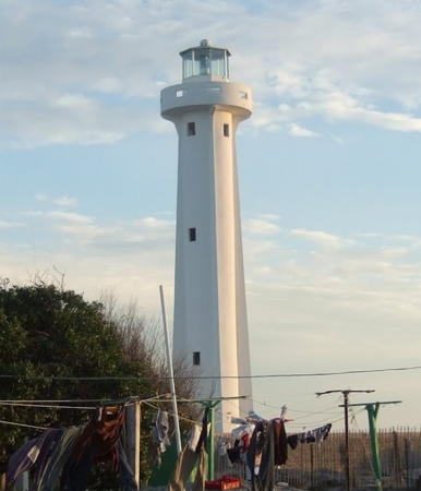
1967. Active; focal plane 190 m (623 ft); white flash every 6 s. 6 m (20 ft) hexagonal cylindrical concrete tower with lantern and gallery, painted with red and white horizontal bands. Hilari and Jim Seery's photo is at the top of this page, José Esteban has a 2017 photo, a 2007 photo is available, Trabas has Capt. Peter's photo, and Google has a satellite view and a street view from the base of the tower. Located on heights above the cape, about 800 m (1/2 mi) northeast of the historic lighthouse. Site open, tower closed. . ARLHS MEX-100; CF-03-305; Admiralty G3586; NGA 14548.

Pacific Coast Lighthouses

La Paz Municipality West Coast Lighthouses
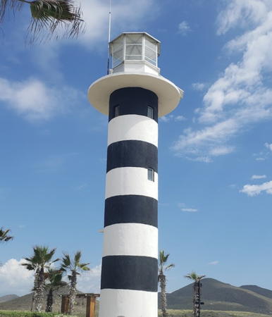
* Todos los Santos
Date unknown. Active; focal plane 13 m (43 ft); white flash every 6 s. 10 m (33 ft) round cylindrical concrete tower with lantern and gallery centered on a square concrete base. Lighthouse painted with black and white horizontal bands. The lantern was added sometime between 2018 and 2021; it is seen in Frida Perez's 2021 photo seen at right and Capt. Peter's view from the sea posted by Trabas. Tim Hebb's 2018 photo, Blake Wirht's 2016 street view from the beach, and Google's satellite view show the tower without the lantern. Located just off the beach about 2 km (1.25 mi) south of Todos los Santos, a town about 45 km (28 mi) north of Cabo San Lucas. The lighthouse is on the grounds of a resort. Site open with permission of the resort, tower closed. Site manager: El Faro Beach Club and Spa. ARLHS MEX-077; CF-03-300; Admiralty G3591; NGA 14544.
Los Inocentes (1)
Date unknown. Inactive. Approx. 10 m (33 ft) round cylindrical concrete tower, painted with red and white horizontal bands. Jose N. Gonzalez has a 2021 photo.
Los Inocentes (2)
Date unknown. Active; focal plane 10 m (33 ft); four white flashes every 16 s. NGA lists an 8 m (26 ft) skeletal tower but Google's satellite view also shows the older concrete tower and Trabas has a distant view by Capt. Peter showing both towers. Located on a remote and deserted stretch of the coast about 30 km (19 mi) northwest of Todos los Santos. Site status unknown. CF-03-1030; Admiralty G3591.5; NGA 14540.
Punta Marquez
Date unknown. Active; focal plane 12 m (39 ft); white flash every 6 s. 10 m (33 ft) square white skeletal tower. Carlos Enrique Salgado Torres has a 2021 photo, Reynaldo García has a 2022 photo, Trabas has Capt. Peter's very distant view from the sea, and Google has a satellite view. NGA spells the name Punta Marquiz. Located on a remote and deserted stretch of the coast about 50 km (30 mi) northwest of Todos los Santos. Site status unknown. CF-03-290; Admiralty G3591.6; NGA 14538.
Arroyo Conejo
Date unknown. Active; focal plane 10 m (33 ft); two white flashes evry 10 s. 8 m (26 ft) square pyramidal white skeletal tower. James Hatton has a closeup street view, Trabas has Capt. Peter's very distant view from the sea, and Google has a distant satellite view. Located on a point of land at El Conejo. Site status unknown. CF-03-285; Admiralty G3591.7; NGA 14536.

Todos los Santos Light, Todos los Santos, May 2021
Google Maps photo by Frida Perez

Comondú Municipality Lighthouses
Cabo Tosco (Punta Tosco)
Date unknown. Active; focal plane 81 m (266 ft); white flash every 6 s. Approx. 11 m (36 ft) square cylindrical tower with gallery, attached to a ruined 1-story keeper's house. Trabas has Capt. Peter's photo (seen at right) and Google has a satellite view. The lighthouse was quite dilapidated in 2001 but it may have been repaired since then. NGA misspells the name as Cabo Tosca. Located on the point of Punta Tosco, the rugged southernmost tip of Isla Santa Margarita, at the southern end of the Bahía Magdalena. Accessible only by boat. Site status unknown. ARLHS MEX-128; CF-03-280; Admiralty G3592; NGA 14532.
Isla Mangrove (San Carlos) Range Front
Date unknown. Active; focal plane 21 m (69 ft); white flash every 3 s. 22 m (72 ft) square skeletal tower, painted white. No photo available and Google has only an indistinct satellite view. This is an approach range for the fishing port of San Carlos. Located on Isla Mangrove about 10 km (6 mi) west of the town. Accessible only by boat. Site open, tower closed. CF-03-260; Admiralty G3594; NGA 14516.
Isla Mangrove (San Carlos) Range Rear
Date unknown. Active; focal plane 27 m (89 ft); white light, 1 s on, 1 s off. 27 m (89 ft) square skeletal tower, painted white. No photo available but Google has a fuzzy satellite view. Located 233 m (765 ft) east of the front light. Accessible only by boat. Site open, tower closed. CF-03-260.1; Admiralty G3594.1; NGA 14520.
Punta Redonda
Date unknown. Active; focal plane 19 m (62 ft); two white flashes every 10 s. 9 m (30 ft) square masonry tower, painted white. No photo available but Google has a distant satellite view. Located at the northwestern end of the Isla Santa Margarita, marking the east side of the principal entrance to the Bahía Magdalena. Accessible only by boat. Site status unknown. CF-03-250; Admiralty G3593; NGA 14504.
 

Cabo Tosco Light, Comondú
photo copyright Capt. Peter Mosselberger; used by permission
 
Cabo San Lazaro
Date unknown. Active; focal plane 70 m (230 ft); white flash every 6 s. 7 m (23 ft) square cylindrical tower with gallery rising from the seaward side of a 1-story keeper's house. Joe Weide's photo is at right, a view from the sea is available, and Google has a satellite view. Located on the cape, which juts into the Pacific west of San Marcos. This is a remote site, difficult to access. Site status unknown. ARLHS MEX-102; CF-03-085; Admiralty G3598; NGA 14500.
* Puerto López Mateos (Matancitas) (2)
Date unknown (around 2007). Active; focal plane about 22 m (72 ft); white flash every 6 s. Approx. 19 m (62 ft) round cylindrical concrete tower with lantern and gallery centered on a square concrete base. Lighthouse painted with red and white horizontal bands. Iveet Montiel Yáñez has a 2018 photo, Pedro Torres has a 2020 closeup photo, Rafael Rodriguez Rodiles has a street view, and Google has a satellite view of the area. This lighthouse replaced a round concrete tower 10 m (33 ft) tall. Located near the visitor center of the Whale Sanctuary of El Vizcaino on the waterfront of Puerto López Mateos. Site open, tower closed. CF-03-080; Admiralty G3598.5; NGA 14496.5.
Boca de Soledad (4?) (?)
Date unknown. Probably destroyed. Listed with focal plane 10 m (33 ft); four white flashes every 16 s. 10 m (33 ft) round cylindrical white concrete tower. No photo available. This light replaced a 10 m (33 ft) skeletal tower pictured in the 2017 Cuaderno. Endangered: this area experiences rapid beach erosion and several earlier lights have been lost. Google has a satellite view that shows the listed location is now in the water, and no lighthouse is seen. Located on the north side of an estuary entrance north of Matancitos. Site open, tower closed. CF-03-075; Admiralty G3598.55; NGA 14496.
Faro de Cabo San Lazaro
Cabo San Lazaro Light, Comondú, December 1996
ex-Panoramio photo copyright Joe Weide; used by permission
* Boca de Santo Domingo (2)
2018. Active; focal plane about 23 m (75 ft); three white flashes every 12 s. 20 m (66 ft) round cylindrical white concrete tower with lantern and gallery painted with red and white horizontal bands. No photo available but Google has a good satellite view. This lighthouse replaced a round concrete tower 10 m (33 ft) tall. Located on the north side of an estuary entrance north of Santo Domingo. Site open, tower closed. CF-03-070; Admiralty G3598.6; NGA 14493.
* Boca de Pabellon (San Andresito) (2)
Date unknown. Active; focal plane about 23 m (75 ft); two white flashes every 10 s. Approx. 20 m (66 ft) round cylindrical concrete tower with gallery centered on a square concrete base. Lighthouse described as painted with red and white horizontal bands, but a distant 2017 view by Sonia Chavez and Google's satellite view show the lighthouse to be all white. Located on the south side of the mouth of the Río Pabellon at Puerto San Andresito. Site open, tower closed. CF-03-065; Admiralty G3598.7; NGA 14492.

Western Mulegé Municipality Lighthouses
* Punta Abreojos
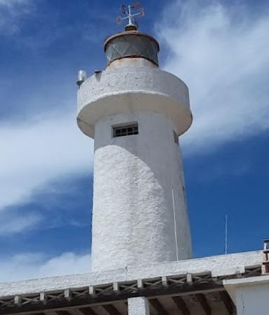
Date unknown. Active; focal plane 25 m (82 ft); three white flashes every 12 s. 20 m (66 ft) ribbed concrete tower with lantern and gallery. Stefan Köstler has the photo seen at right, Trabas has Capt. Peter's distant view from the sea, and Google has a street view and a satellite view. Accessible by 4WD: Punta Abreojos is at the end of 84 km (52 mi) of dirt road. In 2004 at least part of the road was being paved. Located on the beach at the south end of town. Site open, tower closed. ARLHS MEX-047; CF-03-045; Admiralty G3600; NGA 14480.
* San Hipólito
Date unknown. Active; focal plane 14 m (46 ft); four white flashes every 16 s. 10 m (33 ft) round cylindrical concrete tower with gallery, painted with red and white horizontal bands. Trabas has Capt. Peter's photo and Google has a satellite view. Located on a promontory about 150 km (90 mi) south of Guerrero Negro. Accessible by 4WD. Site open, tower closed. CF-03-050; Admiralty G3600.8; NGA 14478.
Isla Asunción
Date unknown. Active; focal plane 9 m (30 ft); white flash every 6 s. 8 m (26 ft) square pyramidal white skeletal tower. Trabas has Capt. Peter's view from the sea and Google has a distant satellite view. Located on a small island at the west entrance to the Bahía Asunción. Accessible only by boat. Site open, tower closed. CF-03-035.1; Admiralty G3600.9; NGA 14477.
Isla San Roque
Date unknown. Active; focal plane 28 m (92 ft); two white flashes every 10 s. 7 m (23 ft) post attached to one side of a 2-story concrete and cinder block building. José Luis Ogawa has a photo, Trabas has Capt. Peter's very distant view, and Google has a satellite view. The nature of the building is not known. The light guides vessels around Cabo San Roque. Located on a small island about 8 km (5 mi) west of Bahía Asunción. Accessible only by boat. Site open, tower closed. CF-03-035; Admiralty G3601; NGA 14476.
Punta Kelp
Date unknown. Active; focal plane 32 m (105 ft); four white flashes every 16 s. 10 m (33 ft) square pyramidal white skeletal tower. Trabas has Capt. Peter's view from the sea and Google has a distant satellite view. Located on a prominent cape at the west entrance to the Bahía Tortuga. Accessible only by boat. Site open, tower closed. CF-03-020; Admiralty G3602.4; NGA 14464.
* Punta Eugenia
Date unknown. Active; focal plane 14 m (46 ft); three white flashes every 12 s. 5.5 m (18 ft) square pyramidal masonry tower with gallery, painted white. John Walker has a photo, Vargas has a small photo and a report on a March 2009 visit, Bill Wiederhold has a 2020 closeup, and Google has a satellite view. Punta Eugenia is the westernmost point of Baja California Sur, separated from Isla Natividad by a strait about 8 km (5 mi) wide. There is a fishing camp in the lee of the point. Located at the point of the cape; accessible by 4WD. Site open, tower closed. CF-03-015; Admiralty G3604; NGA 14460.

Punta Abreojos Light, Punta Abreojos, December 2008
Google Maps photo by Stefan Köstler
Isla Natividad
1938. Active; focal plane 111 m (364 ft); two white flashes every 10 s. 16 m (52 ft) round gray masonry tower rising from a 1-story keeper's house. Ana Margarita Bojorquez Cortes has a closeup 2019 photo and and Google has a satellite view. Isla Natividad is off Punta Eugenia, about 65 km (40 mi) west of Guerrero Negro. The island is popular with surfers. Located at the highest point of the island. Accessible only by boat. Site open; tower apparently open. ARLHS MEX-040; CF-03-010; Admiralty G3606; NGA 14456.
Mal Arrimo (Punta Loco)
Date unknown. Active; focal plane 18 m (59 ft); white flash every 6 s. 12 m (39 ft) round cylindrical concrete tower with gallery, painted with red and white horizontal bands. A closeup photo is available and Google has a distant satellite view. Located on a headland about 25 km (15 mi) east of Punta Eugenia. Site open, tower closed. CF-03-005; Admiralty G3603.5.

Information available on lost lighthouses:

Notable faux lighthouses:

  • Cabo San Lucas Harbor has a 20 m (65 ft) (?) white tower with an observation room and gallery topped by a flat roof. James Smith's photo is at right, Myhre has a 2012 photo, a late 2007 photo is available, and Google has a street view and a satellite view. Many older sources assumed that this tower carries the front light of the Cabo San Lucas range but the Cuaderno de Faros is clear that the range light (circled in the photo) is mounted on the roof of the nearby Hotel Plaza Las Glorias.

Cabo San Lucas: faux lighthouse (right), Front Range Light (circled)
and Rear Range Light; contributed photo copyright James Smith; used by permission

Adjoining pages: Northeast: Eastern Baja California | North: Northwestern Baja California

Return to the Lighthouse Directory index | Ratings key

Checked and revised November 29, 2023. Lighthouses: 35. Site copyright 2023 Russ Rowlett and the University of North Carolina at Chapel Hill.