Lighthouses of Belgium

The Kingdom of Belgium (België in Flemish, Belgique in French) is located between France and the Netherlands in northwestern Europe. This region has a long and complicated history. The present kingdom was established in 1830 following an uprising against rule by the United Kingdom of the Netherlands. It is a bilingual country: 60% of its residents speak Flemish as their first language and 40% speak French. Today Belgium is an international center, hosting in its capital Brussels the headquarters of the European Union and of the North Atlantic Treaty Organization (NATO).

Belgium has a coast on the North Sea about 65 km (40 mi) long, all of it located in the Flemish-speaking province of West Vlaanderen (West Flanders). There are four ports on this coast: Nieuwpoort, Oostende, Blankenberge, and Zeebrugge, and each of the four has its own collection of lighthouses. In each case the principal light is to the east of the harbor entrance; this was done to guide ships approaching from the English Channel to the west.

In addition, Belgium has saved all three of its post-World War II lightships.

Flemish is a southern dialect of Dutch. Thus in Flemish, as in Dutch, the word for a lighthouse is vuurtoren; eiland is an island, ondiepte is a shoal or reef, baai is a bay, zeestraat is a strait, zeegat is an estuary or harbor mouth, kaap is a cape or headland, sluis is a lock, dijk is a dike, rivier is a river, and haven is a harbor.

Aids to navigation in Belgium are the responsibility of the Agentschap Maritieme Dienstverlening en Kust (Agency for Maritime Services and the Coast) of the West Flanders provincial government. However, the lighthouses are probably operated by the respective harbor authorities.

ARLHS numbers are from the ARLHS World List of Lights. BE numbers are from the official Belgian Lichtenlijst. Admiralty numbers are from volume B of the Admiralty List of Lights & Fog Signals. U.S. NGA numbers are from Publication 114.

General Sources
Online List of Lights - Belgium
Photos by various photographers posted by Alexander Trabas. Many photos for Belgium are by Capt. Peter Mosselberger ("Capt. Peter").
Les Sentinelles des Mers - Belgique
Photos and articles by Guy Detienne.
Leuchttürmseiten von Anke und Jens - Belgien
Photos of ten major lighthouses, with notes in English and German.
Leuchttürme.net - Belgien
Excellent photos posted by Malte Werning.
Lighthouses in Belgium
Photos by various photographers available from Wikimedia.
World of Lighthouses - Belgium
Photos by various photographers available from Lightphotos.net.
Belgium Lighthouses
Aerial photos of several of the lighthouses posted by Marinas.com.
Belgische Leuchttürme auf historischen Postkarten
Historic postcard images posted by Klaus Huelse.
Lichtenlijst België
The official Belgian light list is avalable for download in pdf format.
GPSNauticalCharts
Navigational chart information for Belgium.
Navionics Charts
Navigational chart for Belgium.


Nieuwpoort Light, Nieuwpoort, July 2020
Google Maps photo by Frank Soffers
Nieuwpoort Lighthouses
Nieuwpoort is a historic town of about 12,000 residents at the mouth of the River Yser (Ijzer).

Westhinder
About 1992 (lightship station established 1885). Active; focal plane 23 m (75 ft); four white flashes, separated by 4 s, every 30 s. 23 m (75 ft) 4-level steel platform mounted on a cylindrical steel tower; enclosed equipment shelter between the second and third galleries. Fog horn (two short blasts and one long blast every 30 s). Entire structure painted red. Trabas has a photo by Capt. Theo Hinrichs but the light is not shown in Google's satellite view. This modern structure replaced the Westhinder lightships (see near bottom of this page). Located on a notorious shoal just inside Belgian waters about 30 km (19 mi) northwest of Nieuwpoort and a similar distance north of Dunkerque, France. Site open, tower closed. ARLHS BEL-039; BE-0028; Admiralty B0145; NGA 9000.
* Nieuwpoort West Mole
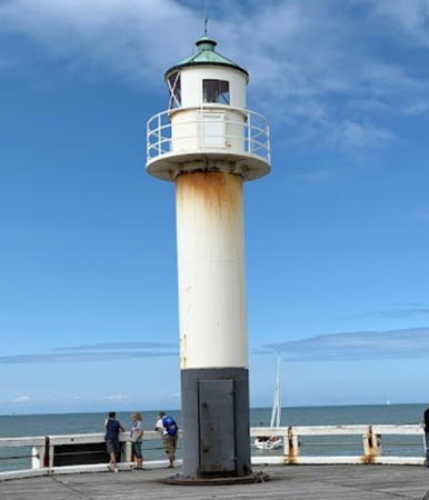
Date unknown (station established 1884). Active; focal plane 11 m (36 ft); continuous green light. Approx. 9 m (29 ft) round cylindrical cast iron tower with lantern and gallery. Tower painted white with a black band at the base; lantern roof painted green. A fog bell hangs on the side of the tower. Trabas has Capt. Peter's closeup photo, Werning has a good photo, a 2017 closeup is available, and Google has a closeup street view and a satellite view. Located on the west side of the entrance to the River Ijzer; readily accessible from the Albert I Laan (boulevard) along the oceanfront. Site open, tower closed. ARLHS BEL-010; BE-0410; Admiralty B0076; NGA 9012.
* Nieuwpoort East Mole
Date unknown (station established 1884). Active; focal plane 11 m (36 ft); continuous red light. Approx. 9 m (29 ft) round cylindrical cast iron tower with lantern and gallery. Tower painted white with a black band at the base; lantern roof painted green. Gerrie Schenck's 2021 photo is at right, Werning has a photo, Trabas has Capt. Peter's closeup photo, and Google has a street view and a satellite view. Huelse has a postcard view that shows an earlier tower. Located on the east side of the entrance to the River Ijzer; accessible by a short hike and walking the mole. Site open, tower closed. ARLHS BEL-009; BE-0412; Admiralty B0075; NGA 9016.
* Nieuwpoort (4)
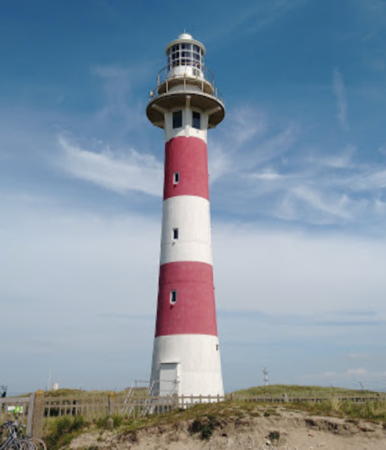
1949 (station established 1863). Active; focal plane 26 m (85 ft); two red flashes, separated by 2.6 s, every 14 s. 29 m (95 ft) round tapered conical concrete tower with lantern and double gallery, painted with horizontal red and white bands; lantern is white. 2-story keeper's house, unoccupied and boarded up. A photo by Frank Soffers is at the top of this page, Trabas has Capt. Peter's photo, Werning has a photo, Wikimedia has several photos, Jan Kica has a 2018 photo, Anke and Jens have a page for the lighthouse, Marinas.com has aerial photos, Huelse has a postcard view, Google has a street view, and Bing has a satellite view. This light is the modern successor to the Vierboet, a 30 m (98 ft) tower built in 1284 in downtown Nieuwpoort. A lantern added to the Vierboat in 1858 survived until it was destroyed in World War I. The 1883 lighthouse, a 26 m (85 ft) square tower, met the same fate and the 1926 lighthouse was destroyed in September 1944, during World War II. The lens of the 1926 lighthouse was preserved in storage in Paris during the war and is in use in the present lighthouse. Huelse has historic postcard views of the 1883 tower and the 1926 tower. Located about 500 m (0.3 mi) east of the East Mole light; not accessible by road but it is possible to walk to the site. Site open, tower closed. . ARLHS BEL-004; BE-0414; Admiralty B0074; NGA 9008.

Nieuwpoort East Mole Light, Nieuwpoort
photo copyright Malte Werning; used by permission

Oostende (Ostend) Lighthouses
Oostende (Ostand in English) is a city of about 70,000 residents. It has a busy port and was formerly a terminal for ferries from England, but the Channel Tunnel has put the ferry services out of business.
* Oostende West Jetty
2021. Active; focal plane 19 m (62 ft); continuous green light. Approx. 17 m (56 ft) round cylindrical tower with lantern. Entire lighthouse is green. Trabas has Capt. Peter's photo, Bert Janssens has a March 2022 photo and Google has a satellite view. Rico Niemann has a photo of the temporary post light used before the lighthouse was installed. Located at the end of the new west breakwater pier of Oostende. Accessible by walking the pier. Site open, tower closed. BE-0436.2; Admiralty B0095.
* Oostende West Pier (2)
2010 (station established 1890). Deactivated around 2015. Approx. 9 m (29 ft) round cylindrical tower with lantern and gallery. Tower painted white with a black band at the base; lantern roof painted green. Capt. Peter Mosselberger's photo is at right, Eleanna Melissa has a 2010 photo, a January 2011 photo is available, Jonas Vandevelde has a 2014 street view, and Bing has a satellite view. The lighthouse was replaced when the Oostende piers were rebuilt in 2009-10, but it seemed to have the same lantern. Werning has a fine closeup photo of the original lighthouse and Huelse has a historic postcard view. The new lighthouse resembled the west pier light at Blankenberge (see below). The lighthouse was removed sometime in 2017-18, restored, and then returned. András Polgár's 2018 street view confirms the removal but Denis Arnaud's October 2021 photo shows the lighthouse back in place. Located on the west side of the entrance to Oostende harbor; accessible by walking the pier. Site open, tower closed. ARLHS BEL-012; ex-BE-0436; ex-Admiralty B0094; NGA 9022.
#Oostende East Pier
1890. Deactivated and demolished in 2010. Approx. 9 m (29 ft) round cylindrical tower with lantern and gallery. Tower painted white with a black band at the base; lantern roof painted green. Werning has a photo taken shortly before the lighthouse was demolished. The east pier was removed in 2010. Google's August 2014 street view by Jonas Vandevelde shows a red buoy marking the former location and also the new radar tower, a triangular white pylon with a red vertical stripe, on the end of the new pier. Formerly located on the east side of the entrance to Oostende harbor. Site open. ARLHS BEL-011; ex-NGA 9024.
Oostende East Jetty
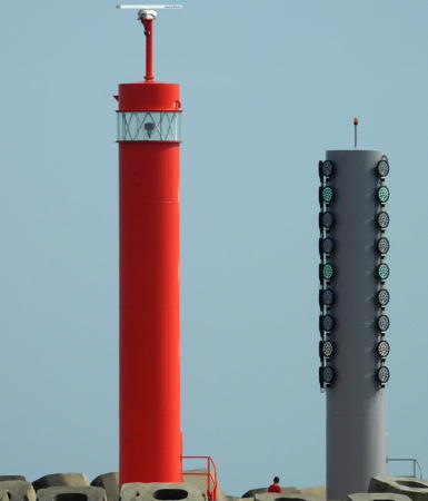
2021. Active; focal plane 19 m (62 ft); continuous red light. Approx. 17 m (56 ft) round cylindrical tower with lantern. Entire lighthouse is red. Trabas has Capt. Peter's photo, an October 2021 photo is available, and Jeronimo Sable's November 2021 photo shows the lighthouse, a signal tower, and the very tall radar tower. Google has a fuzzy satellite view. A small post light was used before the lighthouse was installed. Located at the end of the new east breakwater pier of Oostende. Site and tower closed. BE-0436.3; Admiralty B0096.

Oostende West Mole Light, Oostende, June 2022
photo copyright Capt. Peter Mosselberger; used by permission
Montgomerydok (Basin Montgomery) Entrance
Date unknown. Active; focal plane about 15 m (49 ft); quick yellow flash every 1 s. 12 m (39 ft) square skeletal tower rising from a large round base. Tower painted yellow with a black horizontal band. Trabas has a photo and Google has a satellite view. Located at the entrance to a basin on the west side of lower Oostende harbor. Site status unknown. Admiralty B0103.2.
Oostende Entrance Range Front
Date unknown. Active; focal plane 36 m (118 ft); white light, 2 s on, 2 s off. 32 m (105 ft) triangular skeletal tower painted with red and white horizontal bands. Trabas has Capt. Peter's photo and Google has a satellite view and a distant street view. Located in the harbor area of Oostende. Site and tower closed. BE-0442; Admiralty B0107; NGA 9037.
Oostende Entrance Range Rear
Date unknown. Active; focal plane 46 m (151 ft); white light, 2 s on, 2 s off. 42 m (138 ft) triangular skeletal tower painted with red and white horizontal bands. Trabas has Capt. Peter's photo and Google has a street view and a satellite view. Located in the harbor area of Oostende. Site and tower closed. BE-0444; Admiralty B0107.1; NGA 9037.1.
* Oostende (4) ("Lange Nelle")
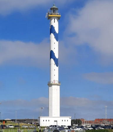
1949 (station established 1771). Active; focal plane 65 m (213 ft); three white flashes every 10 s. 58 m (190 ft) two-stage round cylindrical tower with lantern and double gallery rising from the center of a square 1-story building. Lower 1/3 of the tower is octagonal and probably concrete, upper 2/3 circular and probably brick. Lighthouse painted white with two sinusoidal blue bands around the upper section; galleries painted gold. The unusual color pattern was added in 1994. Hans-Jurgen Maesschalck's 2023 photo is at right, Werning has a photo, Trabas has Capt. Peter's photo, Wikimedia has photos, Anke and Jens have a page for the lighthouse, Marinas.com has aerial photos, and Google has a street view and a satellite view. This remarkable lighthouse, nicknamed Lange Nelle (Tall Nellie), appears pencil-thin compared to its great height. In 1991 crumbling concrete led to concerns for the structure, but engineers found a way to restore it; the current blue and white daymark was added at that time. Detienne has the history of the earlier lighthouses: the 1860 lighthouse was destroyed in World War I, and the original 1771 lighthouse and the 1925 lighthouse were destroyed in World War II. Huelse has historic postcard views of the 1860 tower, a 52 m (171 ft) round stone tower, and the 1925 tower. Located about 500 m (0.3 mi) east of the East Pier light. Site open, tower closed. . ARLHS BEL-002; BE-0440; Admiralty B0092; NGA 9020.

Oostende Light (Lange Nelle), Oostende, August 2023
Google Maps photo by Hans-Jurgen Maesschalck

Blankenberge Lighthouses
Blankenberge is a town of about 20,000 residents, best known as a seaside resort.
* Blankenberge West Mole (2)
Date unknown (station established 1913). Active; focal plane 14 m (45 ft); continuous green light. 8 m (26 ft) round cylindrical cast iron tower with lantern and gallery. Tower painted white with a black band at the base. Trabas has Capt. Peter's closeup photo, Peter Heffner has a 2018 photo, and Google has a street view and a satellite view. Located on the west side of the entrance to Blankenberge harbor; accessible by walking the pier. Site open, tower closed. ARLHS BEL-006; BE-0458; Admiralty B0113.4; NGA 9052.
* Blankenberge East Mole (2)
Date unknown (station established 1913). Active (?); focal plane 12.5 m (41 ft); continuous red light. 8 m (26 ft) round cylindrical cast iron tower with lantern and gallery. Tower painted white with a black band at the base. Andreas Köhler has a 2018 photo, a 2021 photo is available, Davy Joos has a closeup street view, and Google has a satellite view and a distant street view. This lighthouse replaced a round cylindrical cast iron tower with lantern and gallery. Werning has a good photo of the previous lighthouse. Trabas has Capt. Peter's photo showing that the light had been moved to a short red post in front of the lighthouse. However, the latest Belgian light list continues to describe the lighthouse with no reduction in focal plane, so this move may be (or may have been) temporary. Located on the east side of the entrance to Blankenberge harbor; accessible by walking the pier. Site open, tower closed. ARLHS BEL-005; BE-0460; Admiralty B0114; NGA 9048.
* Blankenberge (Jetée Comte Jean) (4)
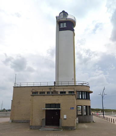
1950 (station established 1817). Active; focal plane 32 m (106 ft); two white flashes every 8 s. 30 m (98 ft) cylindrical concrete tower with lantern and gallery rising from a 2-story brick building. This modern tower has a U-shaped cross section with the curved side facing the sea; it is white, except the lantern and top floor (watch room) are painted black. Marc Ryckaert's photo is at right, Trabas has Capt. Peter's photo, Wikimedia has several photos, Marc de Kleijn has a photo, Katarzyna Sma has a 2023 photo, Anke and Jens have a page for the lighthouse, Marinas.com has aerial photos, Huelse has a postcard view, and Google has a street view and a satellite view. The building at the base of the lighthouse was formerly a museum, but the facility has closed. Huelse also has a historic postcard view of the 1872 lighthouse, a 23 m (75 ft) octagonal stone tower; it was destroyed in World War II. According the Detienne the earlier lights were in "different places." Located at the base of the east pier, known as the Comte Jean jetty, behind the east pier light. Site open, tower closed. Site manager: unknown. . ARLHS BEL-001; BE-0462; Admiralty B0112; NGA 9044.
Blankenberge Light
Blankenberge Light, Blankenberge, September 2014
Wikimedia Creative Commons photo by Marc Ryckaert

Brugge (Bruges) Lighthouses
The historic city of Brugge (Bruges) is the capital and largest city of West Flanders, with a population of about 120,000. Zeebrugge is a former village, now the port district of Brugge. It is the busiest port of the Belgian coast and is the terminal for ferries from Hull, England.
Zeebrugge West Breakwater (3?)
Date unknown (station established 1905). Active; focal plane 31 m (102 ft); green light, occulting once every 7 s. 30 m (98 ft) unpainted octagonal concrete tower with gallery topped by a small green lantern and a radar transmitter on a white mast. The tower also carries an array of traffic control lights. Nautophone fog signal (3 blasts every 30 s). Trabas has a photo, Werning has a more distant view, Jeronimo Sable has a 2021 view from the sea, Frank Stainer has a 2022 photo, and Google has a satellite view. Located at the end of the west breakwater outside the entrance to Zeebrugge harbor. Site and tower closed. ARLHS BEL-040; BE-0470; Admiralty B0123.2; NGA 9073.
Zeebrugge East Breakwater (2?)
Date unknown (station established 1905). Active; focal plane 31 m (102 ft); red light, occulting once every 7 s. 30 m (98 ft) unpainted octagonal concrete tower with gallery topped by a small red lantern. The tower also carries an array of traffic control lights. Fog bell (3 strokes every 25 s). Werning has a photo, Trabas has Capt. Peter's photo, Ralf Pätzold has a view from the sea, and Google has a satellite view. Dominique and Béatrice Lestienne have a 2019 photo showing the row of tall wind turbines on the breakwater behind the lighthouse. Located at the end of the east outer breakwater outside the entrance to Zeebrugge harbor. Accessible only by boat. Site and tower closed. ARLHS BEL-015; BE-0472; Admiralty B0123; NGA 9074.
Zeebrugge Old Mole (Leopold II Dam)
1905. Active; focal plane 22 m (72 ft); continuous white or red light, depending on direction. Approx. 18 m (60 ft) unpainted round concrete tower with lantern and gallery, rising from circular 1-story concrete building. Lantern painted red; lantern roof is greenish metallic. The tower also carries an array of traffic control lights. Philip Sadin's 2020 photo is at right, Werning has a photo, Trabas has Darlene Chisholm's photo, Wikimedia has a view from the harbor, Anke and Jens have a page for the lighthouse, Huelse has a historic postcard view, and Google has a satellite view. The lighthouse was repaired after being heavily damaged during a British raid on Zeebrugge in April 1918, during World War I. Huelse has a postwar postcard view showing the damage. Located at the end of the Old Mole (now called the Leopold II Dam) on the west side of Zeebrugge harbor. Site and tower closed. ARLHS BEL-046; BE-0496; Admiralty B0122; NGA 9076.
Zeebrugge Inner Harbor Range Rear
Date unknown. Active; focal plane 29 m (95 ft); continuous white neon light. Approx. 26 m (85 ft) triangular skeletal tower painted with black and white horizontal bands. Trabas has Capt. Peter's photo and Google has a satellite view. The front light is on a tall mast. Located on a quay on the west side of Zeebrugge harbor. Site and tower closed. BE-0499.2; Admiralty B0128.1; NGA 9092.

Zeebrugge Old Mole Light, Zeebrugge, September 2020
Google Maps photo by Philip Sadin
* [Zeebrugge Zeesluis (Omookaai)]
1895. Inactive. 3 m (10 ft) round cylindrical cast iron tower with lantern and gallery; the gallery rail in missing. Werning has a photo and Google has a satellite view and a distant street view. This is one of two identical pierhead lights from the former sea lock at the entrance to the Zeebrugge Kanal, known to have been in place before World War I. (No one seems to know if this was the east or the west pierhead light.) Located at the end of the Omookaai not far from the West-Hinder. Site open, tower closed.
Zeebrugge Outer Harbor Range Front
Date unknown. Active; focal plane 20 m (66 ft); white or red light depending on direction, 4 s on, 2 s off, synchronized with the rear light. Approx. 18 m (59 ft) triangular skeletal tower atop a round concrete tower. The concrete tower is painted with red and white horizontal bands. Trabas has Capt. Peter's photo and Google has a satellite view. This range guides ships after they enter the outer harbor. Located in the containership port. Site and tower closed. BE-0512.1; Admiralty B0125; NGA 9096.
* Zeebrugge Outer Harbor Range Rear
Date unknown. Active; focal plane 36 m (118 ft); white or red light depending on direction, 4 s on, 2 s off, synchronized with the front light. Light mounted on a port authority building. A daymark panel with red and white horizontal bands is mounted below the light. Trabas has Capt. Peter's photo and Google has a street view and a satellite view. Located 520 m (1/3 mi) south southeast of the front light. Site open, tower closed. BE-0512.2; Admiralty B0125.1; NGA 9100.
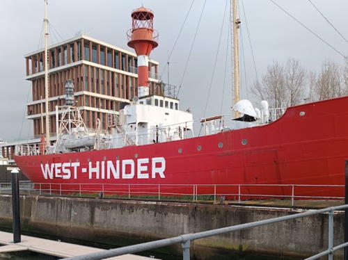
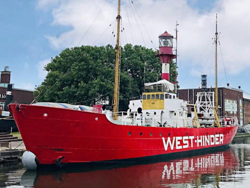
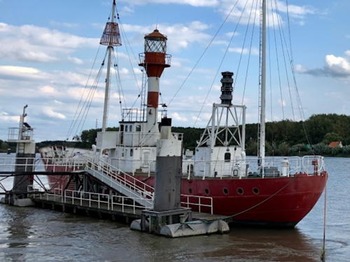
*** Lightship 2 (West-Hinder II)
1950. Decommissioned 1994. 37.5 m (123 ft) steel lightship; the light was displayed from a lantern atop the mainmast. Hull painted red, superstructure white, mast with red and white horizontal bands, lantern red. A photo by Uwe Aranas is at right, Tim Roosen has a 2007 photo, a 2009 photo is available, Michiel Ronde has a street view on board the ship, and Google has a 2017 street view and a satellite view. One of three lightships built by Beliard, Crighton & Co. of Oostende. The ship is dry-berthed as an attraction in a maritime theme park; a souvenir shop occupies part of the vessel. Located out of the water but on the waterfront in Zeebrugge. Site open, theme park and ship open daily (admission fee). Owner/site manager: Seafront Zeebrugge. ARLHS BEL-003.

Lightship West-Hinder II, Zeebrugge, July 2014
Wikimedia Creative Commons photo by CEphoto, Uwe Aranas
* Zeebrugge (Heist) Range Front (2)
1977 (range established 1912). Active; focal plane 22 m (72 ft); white light occulting once every 5 s, synchronized wth the rear light. Approx. 20 m (66 ft) slender round cylindrical tower with gallery but no lantern, painted with red and white horizontal bands. Werning has a photo, Trabas has Capt. Peter's photo, and Google has a satellite view. This is the entrance range for Zeebrugge. Located on a mole at Heist, on the east side of Zeebrugge harbor. Site open, tower closed. ARLHS BEL-013; BE-0540; Admiralty B0124; NGA 9068.
*** Zeebrugge (Heist) Range Front (1)
1912. Inactive since 1977. Approx. 9 m (30 ft) conical round concrete (?) tower with circular lantern and gallery. Structure appears to be unpainted. This lighthouse is located near the current rear range light; the modern front light is 875 m (1/2 mi) northwest. Werning has a closeup photo, Trabas has Capt. Peter's photo of this light and the current rear light, Wikimedia has numerous photos, Anke and Jens have a page for the lighthouse, Google has a closeup street view, and Huelse has a historic postcard view. Located at the foot of Konigslaan in Zeebrugge. Site open, tower closed. Owner/site manager: unknown. ARLHS BEL-045.
* Zeebrugge (Heist) Range Rear (2)
1977 (range established 1912). Active; focal plane 45 m (148 ft); white light occulting once every 5 s, synchronized wth the front light. Approx. 40 m (130 ft) slender round cylindrical tower with lantern and gallery, painted with red and white horizontal bands. Werning has a photo, Trabas has Capt. Peter's photo of this light and the old front light, and Google has a street view and a satellite view. The lighthouse stands just behind the original front range light (previous entry) near the foot of Konigslaan in Zeebrugge. Site open, tower closed. ARLHS BEL-014; BE-0542; Admiralty B0124.1; NGA 9072.
* Zeebrugge (Heist) Range Rear (1)
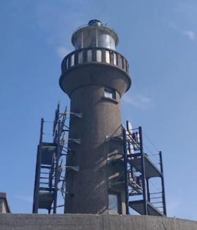
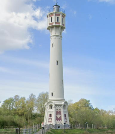
1907. Inactive since 1977. Approx. 24 m (80 ft) round concrete tower rising from an octagonal base and supporting a large octagonal watch room, lantern and gallery. Base and watch room faced partly with red brick. Marc Ryckaert's photo is at right, Werning has a good photo, Wikimedia has numerous photos, Patrick Hoste has a 2023 photo, Anke and Jens have a page for the lighthouse, Huelse has a historic postcard view, and Google has a street view and a satellite view. This handsome and historic lighthouse was reported in poor condition as recently as 1998 but it was restored in 2004; when Manfred Schmidt visited in October 2018 he found additional restoration work in progress. Located just off the Konigslaan in Zeebrugge, about 250 m (1/4 mi) southeast of the old front light. Site open, tower closed. Owner/site manager: unknown. . ARLHS BEL-047.
Heist Range Rear Light
1907 Heist Range Rear Light, Zeebrugge, March 2011
Wikimedia Creative Commons photo by Marc Ryckaert

Knokke Lighthouse
* Knokke (replica)
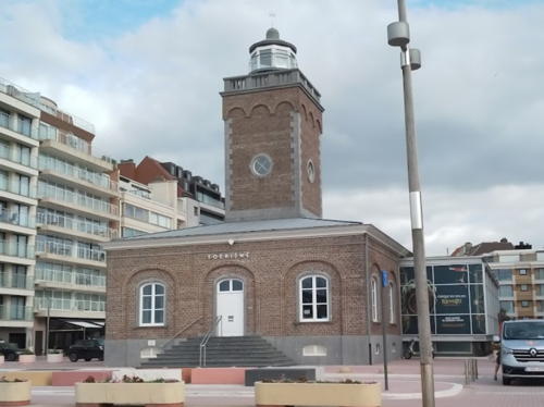
Date unknown (replica of 1872 lighthouse). Inactive. Approx. 15 m (49 ft) square cylindrical red brick tower centered on a 1-story red brick building. A 2023 photo is at right, Wayne Hopkins has a 2010 closeup photo, Wikimedia has a photo, Hans Ouwens has a photo, and Google has a closeup street view and a good satellite view. Huelse has a historic postcard view of the original lighthouse, which was deactivated in 1914 and demolished in 1952. The replica was built as the local tourism office. Located on the Lichttorenplein on the waterfront of Knokke, a town on the east side of Zeebrugge. Site open, building open, tower status unknown. ARLHS BEL-044.

Lightship on the Brugge-Gent Canal
** Netherlands Lightship 3 (Mayflower)
1884. Decommissioned 1939. 34.2 m (112 ft) two-masted wooden lightship, stripped of its original fittings. A modern superstructure and faux lantern has been built on the middle of the ship. Hull painted red, superstructure white. Detienne has a page for the lightship, a 2009 photo is available, and Google has a street view and a satellite view. Urbain Ureel rediscovered this vessel and researched its history. The ship's last assignment was as the Haaks from 1925 to 1930. Sold for scrap in 1939, the ship was stripped of its equipment and the hull sold to a youth organization. Incongruously renamed Hollands Glorie (the name of the organization), the ship served as a floating dormitory. Sold again in 1976, the ship was moved first to Oostende and then to Brugge, where it has served since 1978 as a floating bar and restaurant. The current owners added the faux lantern to the top of the superstructure as a reminder of the ship's history. Moored at Bargeweg 13 on the Brugge-Gent Kanal near the Minnewater park in Brugge. Site and vessel open. Owner/site manager: Mayflower Restaurant. ARLHS BEL-048.
 

Knokke Light replica, Knokke, July 2023
Google Maps photo by Ce Fi

Lightships on the Schelde
Alexander Trabas has photos of aids to navigation on the Schelde estuary leading to Antwerpen, but none of them qualify as lighthouses by the Directory's definition.
* Lightship 3 (West-Hinder III)
1950. Decommissioned 1992. 37.5 m (123 ft) steel lightship; light was displayed from a lantern atop the mainmast. Hull painted red, superstructure white, mast with red and white horizontal bands, lantern red. A photo by Marc Delforge is at right, a 2008 photo is available, and Google has a 2017 street view of the ship and a satellite view of its current location. One of three lightships built by Beliard, Crighton & Co. of Oostende; the ships alternated in serving the two lightship stations of Wandelaar and West-Hinder. In 1960 the ship was heavily damaged when it was rammed by the Norwegian tanker Branita. In fact it sank while being towed to Oostende for repairs, but it was successfully salvaged and returned to duty. In 1995 the lightship was donated to the city of Antwerpen for display at Belgium's national maritime museum, where it remains. In May 2003 Iris Klempau found it to be in poor condition but since then it has been fully restored. In June 2018 the ship was towed to a drydock for routine maintenance, but it was back on display for the 2019 season. When Manfred Schmidt visited in September 2020 he found it had been moved back to a drydock for repairs. A May 2021 street view showed it still in drydock. The museum's foundation, the Stichting Maritiem Patrimonium, proposed to complete the restoration with parts taken from West-Hinder I, but the Municipality of Kruibeke firmly rejected that idea. The plan was to complete the restoration and reopen the ship to visitors in 2022. We need current information on its status. Since early 2022 the ship has been moored at the Kattendijk Dock in downtown Antwerpen. Site appears open, vessel closed. Owner/site manager: Museum aan de Stroom. ARLHS BEL-027.
** Lightship 1 (West-Hinder I)
1950. Decommissioned 1972. 37.5 m (123 ft) steel lightship; light was displayed from a lantern atop the mainmast. Hull painted red, superstructure white, mast with red and white horizontal bands, lantern red. Roger Van Buynder has a photo, Carol Bamps has a July 2021 street view, Dirk De Baere has a photo, Roger Van den Steen has a view from the river, and Google has a satellite view. One of three lightships built by Beliard, Crighton & Co. of Oostende. The ship was sold in 1976 and used as a floating restaurant, first in Brugge and then in Oostende. It sank at its berth in 1978 but was refloated. Sold for scrap in the late 1980s, it was saved but languished for many years. In 2002 it was towed to Rupelmonde, on the Scheldt above Antwerpen. In 2012 the original foghorn was returned to the ship. The ship was leased to a catering business which made it available for parties and special events. This business went bankrupt in 2018. The city has decided to retain the ship and work on restoring it. Moored on the Nederstraat in Rupelmonde. Site open, ship status unknown pending further developments. Owner/site manager: Municipality of Kruibeke. ARLHS BEL-026.
West-Hinder III
Lightship Westhinder III, Antwerpen, June 2010
Flickr Creative Commons photo by Marc Delforge

Information available on lost lighthouses:

Notable faux lighthouses:

Adjoining pages: North: Southern Netherlands | South: France North Coast

Return to the Lighthouse Directory index | Ratings key

Posted January 4, 2005. Checked and revised November 28, 2023. Lighthouses: 26; lightships: 4. Site copyright 2023 Russ Rowlett and the University of North Carolina at Chapel Hill.