Lighthouses of China: Zhànjiāng, Guǎngdōng

The People's Republic of China (PRC), known officially as Zhōnghuá (中华), has a lengthy coastline, many large harbors, and a large number of lighthouses. The country is divided into 23 provinces and 11 other province-level regions of various special types. The province of Guǎngdōng (formerly spelled Kwangtung) is located on the southern coast of the country facing the South China Sea. Its coastline is rugged and irregular, with many islands and reefs threatening unwary navigators.

Guǎngdōng is divided into 21 prefectural-level cities. The prefectural-level city of Zhànjiāng is a major port near the south end of the province. This page describes lighthouses of the Zhànjiāng area, including the northern half of Zhànjiāng Prefecture. There's another page for lighthouses of the Léizhōu Peninsula, the southern half of Zhànjiāng Prefecture.

The seaport of Zhànjiāng was leased to France as a colony called Guǎngzhōuwān (officially Kouang-Tchéou-Wan and also spelled Kwangchowan) from 1898 until it was captured by Japanese troops in 1943. Kwangchowan was returned to Chinese control in 1946. The Náozhōu Lighthouse shown at right is the only surviving French lighthouse in Zhànjiāng.

There are many languages and dialects spoken in China, but Standard Chinese, often called Mandarin, is official. The pīnyīn system for transliterating Standard Chinese into Latin characters is now the international standard but some locations continue to be known also under the spellings of older transliteration systems. The Chinese word for a lighthouse is dēngtǎ (灯塔). In Standard Chinese jiāo (formerly chiao) is a reef or rock, jiǎo is a cape or headland, dǎo (tao) is an island; (tsu) or tuózi ("lump") is a small island, hǎi is a sea, wān is a bay, hǎixiá is a strait, or jiāng is a river, hékǒu ("river mouth") is an estuary, and gǎng (kang) is a harbor.

Lighthouses in China are maintained by the PRC Maritime Safety Administration. The administration is organized in four regional administrations, with district offices in the major ports. The lights on this page are maintained by the Zhànjiāng MSA office, which is included in the Guǎngzhōu Region.

ARLHS numbers are from the ARLHS World List of Lights. CN numbers are the MSA List of Lights (助航标志表) numbers. Admiralty numbers are from volume P of the Admiralty List of Lights & Fog Signals. U.S. NGA List numbers are from Publication 112.

General Sources
Chinese English Pinyin Dictionary
A useful tool for juggling the representations of Chinese names.
Online List of Lights - China
Photos by various photographers posted by Alexander Trabas.
Leuchttürme Chinas auf historischen Postkarten
Historic postcard images posted by Klaus Huelse.
Navionics Charts
Navigation chart information for Guǎngdōng.
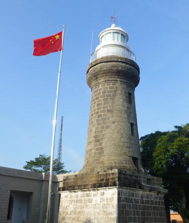

Náozhōu Light, Tiānyá, November 2018
Wikimedia Creative Commons photo by
Wúchuān City Lighthouses
The county-level city of Wúchuān faces the South China Sea northeast of Zhànjiāng. The city's population is about 1.3 million.

*
Hǎishāpō
Date unknown. Active; focal plane 14 m (46 ft); two white flashes every 6 s. Approx. 10 m (33 ft) round cylindrical white concrete tower. No photo available but Google has a satellite view. Located just off the beach at Hǎishāpō ("Ocean Beach") about 25 km (15 mi) east of Wúchuān. Site appears open, tower closed. CN-4674.37; Admiralty P3403.25.
* Wǔcūn
Date unknown (recent). Active; focal plane 9 m (30 ft); flashing red light. Approx. 7.5 m (25 ft) round concrete tower. No photo available but Google has a satellite view. Located on the east side of the entrance to Wǔcūn harbor, a short distance west of the Hǎishāpō lighthouse. Site appears open, tower closed. CN serial 7710416.01; Admiralty P3403.191.
* Jízhào
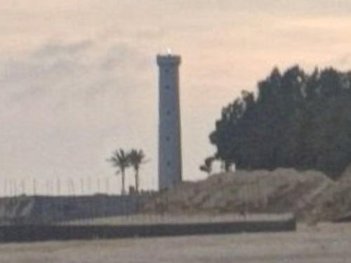
2010. Active; focal plane 23 m (75 ft); quick-flashing white light. 20 m (66 ft) round concrete tower. Entire lighthouse is white. A sunrise view (second photo on the page) is available and Google has a satellite view and the distant street view seen at right. Jízhào is a very popular beach resort. Located just off the beach on a point of land about 15 km (9 mi) southeast of central Wúchuān. Site appears open, tower closed. CN-4674.7; Admiralty P3403.15.
Bómào
Date unknown. Active; focal plane unknown; white flash every 4 s. 8 m (26 ft) white concrete tower. No photo available and the light is not seen in Bing's satellite view. This is a leading light for vessels entering the the eastern mouth of the Jiàn River, Bómào's harbor. Located on heights above the east bank of the river. Site status unknown. CN-4675; Admiralty P3403.
Bómào Breakwater
Date unknown. Active; focal plane about 14 m (46 ft); two green flashes every 6 s. Approx. 12 m (39 ft) round cylindrical white concrete tower. No photo available but Google has an indistinct satellite view. Located at the end of the breakwater on the east side of the entrance to Wúchuān. Site status unknown. CN-4675.4; Admiralty P3402.
* Wúyángzhèn
Date unknown. Active; focal plane 16 m (52 ft); two white flashes every 6 s. Approx. 15 m (49 ft) round cylindrical white concrete tower. No photo available but Google has a satellite view. Located just off the beach at Wúyángzhèn about 20 km (13 mi) southwest of Wúchuān. Site appears open, tower closed. CN-4675.5; Admiralty P3401.5.

Jízhào Light, Wúchuān, May 2018
Google Maps street view

Pōtóu District: Nánsāndǎo (Nánsān Island) Area Lighthouses
Nánsān is a large island east of Zhànjiāng, forming the north side of Zhànjiāng Bay. The island is governed as part of Pōtóu District of Zhànjiāng City.

Líjián Mén
Date unknown. Active; focal plane about 26 m (85 ft); three white flashes every 10 s. 20 m (66 ft) round cylindrical white concrete tower. No photo available but Google has a satellite view. This light stands on the south side of the entrance to the Jiàn River and the north side of the entrance to the Nánsān Channel, which separates Nánsān Island from the mainland. Site status unknown. CN-4684.5; Admiralty P3370; NGA 20013.
Nánsān Dǎo East Range Front (3)
1990 (station established 1918). Active; focal plane 24 m (79 ft); three white flashes every 4 s. 19 m (62 ft) hexagonal concrete tower. Lighthouse painted white with a black vertical stripe on the range line. No photo available but Google has a satellite view. This is a harbor entrance range for vessels arriving from the south. Located at the southeastern tip of Nánsān Island, marking the north side of the entrance to Zhànjiāng harbor. Site status unknown. CN-4721; Admiralty P3374; NGA 20024.
Nánsān Dǎo East Range Rear (3)
1990 (station established 1916). Active; focal plane 46 m (151 ft); continuous white light. 16 m (52 ft) hexagonal concrete tower with gallery, painted white with a black vertical stripe on the range line. No photo available but Google has a satellite view. Located 1100 m (2/3 mi) northwest of the front light. Site status unknown. CN-4722; Admiralty P3374.1; NGA 20028.
Nánsān Dǎo West Range Rear (2)
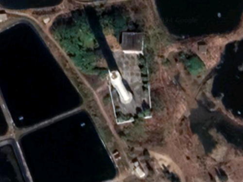
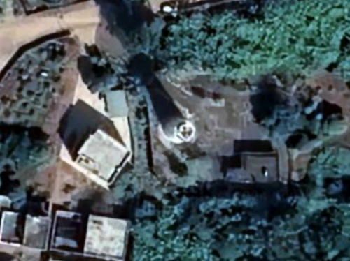
Date unknown (station established 1956). Active; focal plane 30 m (98 ft); continuous light, white, red or green depending on direction. 32 m (105 ft) round cylindrical concrete tower with a conical base and a large observation and control structure near the top. Lighthouse painted white with a red vertical stripe on the range line. No photo available but Google has the satellite view. seen at right. This range guides ships departing Zhànjiāng harbor. Located near the southern tip of Nánsān Island. Site status unknown. CN-4724; Admiralty P3378.1; NGA 20036.
Nánsǎn Dǎo West Range Front (2)
1990 (station established 1956). Active; focal plane 30 m (98 ft); two white flashes every 4 s. 23 m (75 ft) hexagonal concrete tower with gallery, painted white with a black vertical stripe on the range line. No photo available but Google has a satellite view. Located near the southern tip of Nánsān Island, 800 m (1/2 mi) west southwest of the rear light. Site status unknown. CN-4723; Admiralty P3378; NGA 20032.

West Range Rear Light, Nánsān Dǎo
Google Maps satellite view

Pōtóu District: Zhànjiāng Estuary East Bank Lighthouses
The city of Zhànjiāng is built along an estuary that opens out below the city to form a broad bay called Zhànjiāng Hǎiwān or Zhànjiāng Sea Bay. In late 2006 the spectacular Zhànjiāng Hǎiwān Bridge opened across the estuary just above the city center. Navigation of the Zhànjiāng estuary is aided by a series of range lights, but rapid waterfront development has forced frequent replacement of these lights. A number of substantial and interesting lighthouses have been lost as a result.

Máxié Ferry
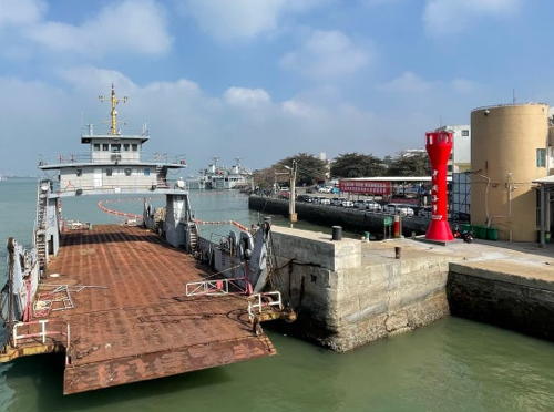
Date unknown. Active; focal plane 10.5 m (35 ft); flashing white light. 9 m (30 ft) round red barbell-shaped tower. A photo is at right and Google has a satellite view. Located on the Máxié ferry pier. Site status unknown. CN-4759.5; Admiralty P3382.15; NGA 20080.1.
Máxié Range Front
Date unknown. Active; focal plane 17 m (56 ft); continuous red light. 13 m (43 ft) white masonry tower with gallery. No photo available but Google has a satellite view. This range guides vessels approaching the city. Located on the waterfront of the Máxié District, on the east side of the estuary opposite downtown Zhànjiāng. Site and tower closed. CN-4760; Admiralty P3382; NGA 20076.
Máxié Range Rear
Date unknown. Active; focal plane 22 m (72 ft); continuous red light. 18 m (59 ft) white masonry tower with gallery. No photo available but Google has a satellite view. Located beside a street 160 m (0.1 mi) north northeast of the front light. Site status unknown. CN-4761; Admiralty P3382.1; NGA 20080.
 

Máxié Ferry Light, Zhànjiāng
unattributed photo posted by foursquare.com_
 
* Mòyānlóu Range Front (2)
1988 (station established 1970). Active; focal plane 15 m (49 ft); continuous red light. 12 m (39 ft) concrete tower with lantern and gallery, painted white with a black vertical stripe on the range line. Google has a street view and a satellite view. The range guides vessels up the estuary past downtown Zhànjiāng. The lighthouses appear to be in park areas accessible by paved walkways. Located on the east side of the harbor in the Pōtóu District, about 1.5 km (2.5 mi) south of the Zhànjiāng Haiwan Bridge. Site open, tower closed. CN-4763; Admiralty P3382.3; NGA 20082.
* Mòyānlóu Range Rear (2)
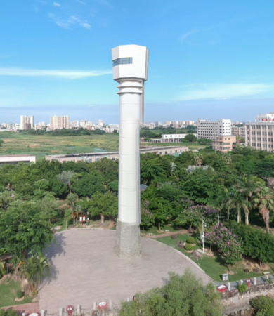
1990 (station established 1970). Active; focal plane 18 m (56 ft); continuous red light. 15 m (49 ft) round cylindrical white concrete tower with an octagonal lantern structure. Google has a street view (also seen at right) and a satellite view. Located 460 m (0.29 mi) north northeast of the front light. Site open, tower closed. CN-4764; Admiralty P3382.31; NGA 20082.1.

Chìkǎn District (North Zhànjiāng City) Lighthouse
Jiālóng Pier
Date unknown. Active; focal plane 11 m (36 ft); white flash every 4 s. Approx. 10 m (33 ft) round white concrete tower. No photo available but Google has a satellite view. Located at Jiālóng on the west bank of the Zhànjiāng estuary about 8 km (5 mi) north of the city center. Site status unknown. CN serial 7811661; Admiralty P3382.44.
Jiālóng North
Date unknown. Active; focal plane 8 m (26 ft); red flash every 3 s.10 m (33 ft) white masonry tower. No photo available but Google has an indistinct satellite view. Located on the west bank of the Zhànjiāng estuary about 1 km (0.6 mi) south of the Jialong Pier Light. Site status unknown. CN-4783; Admiralty P3382.434.
Jiālóng South
Date unknown. Active; focal plane 9.5 m (31 ft); two white flashes every 6 s.11 m (36 ft) white masonry tower. No photo available but Google has a satellite view. Located in an industrial port on the west bank of the Zhànjiāng estuary about 1.1 km (0.7 mi) south of the Jialong North Light. Site status unknown. CN-4782; Admiralty P3382.432.

Mòyānlóu Range Rear Light, Zhànjiāng, June 2018
Google Maps street view by pxkill WECHAT_

Xiáshān District (Central Zhànjiāng City) Lighthouse
Diàoshùn (Tiaoshun) Dǎo Pier Basin Range Front (2?)
Date unknown. Active; focal plane 14 m (46 ft); continuous green light. Approx. 11 m (36 ft) white brick (?) tower. No photo available but Google has a satellite view. This range guides ships toward docks on the upper Zhànjiāng estuary. Located on the waterfront on the west side of the estuary about 3 km (2 mi) north of the Zhànjiāng Haiwan Bridge. Site status unknown. CN-4776.1; Admiralty P3382.425; NGA 20083.2.
Diàoshùn (Tiaoshun) Dǎo Pier Basin Range Rear (2?)
Date unknown. Active; focal plane 19 m (62 ft); continuous green light. Approx. 11 m (36 ft) white brick (?) tower. No photo available; the tower is not seen in Google's satellite view and the light may have been moved to a nearby building. Located in trees 440 m (1/4 mi) northwest of the front light. Site status unknown. CN-4776.11; Admiralty P3382.426; NGA 20083.3.
* Diàoshùn (Tiaoshun) Dǎo Range Front (4)
2016 (station established 1970). Active; focal plane 16 m (52 ft); red light, 2 s on, 2 s off, synchronized with the rear light. 8 m (26 ft) concrete tower with gallery, painted white with a black vertical stripe on the range line. Google has a distant drone view and a satellite view. The range guides vessels up the estuary beyond the city of Zhànjiāng. Located on a point of land at a bend in the estuary about 3 km (2 mi) northwest of the Zhànjiāng Haiwan Bridge. The area appears to be accessible and may be a public park. Site open, tower closed. CN-4769; Admiralty P3382.421; NGA 20084.
* Diàoshùn (Tiaoshun) Dǎo Range Rear (3)
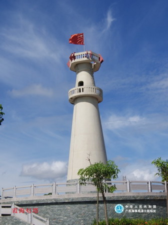
2010 (station established 1970). Active; focal plane 25 m (82 ft); red light, 2 s on, 2 s off, synchronized with the front light. 23 m (75 ft) square concrete tower with gallery, painted white with a black vertical stripe on the range line. Google has a drone view and a satellite view. This light appears to be a sibling of the 1989 Xiáhǎi Range Rear Light pictured at right. The second (1991) lighthouse was 16 m (52 ft) tall. Located about 275 m (300 yd) northwest of the front light. Site open, tower closed. CN-4770; Admiralty P3382.422; NGA 20084.1
Xiáhǎi Range Front (5)
2018(?). Active; focal plane 32 m (105 ft); red light, 2 s on, 2 s off. 27 m (89 ft) tapered round concrete tower mounted on a circular pier. No photo available but Google has a satellite view. This range guides vessels southbound (downstream) toward Zhànjiāng. Located just offshore north of the Zhànjiāng Haiwan Bridge. Accessible only by boat but easily seen from nearby. Site status unknown. CN-4767; Admiralty P3382.4; NGA 20083.
Xiáhǎi Range Rear (5)
2018(?). Active; focal plane 38 m (125 ft); red light, 2 s on, 2 s off. 33 m (108 ft) tapered round concrete tower. No photo available but Google has a satellite view. This light replaced a temporary light mounted on a building. Located on a quay 240 m (788 ft) south southwest of the front light. Site status unknown. CN-4768; Admiralty P3382.41; NGA 20083.1.
* Xiáhǎi Range Rear (2)
1989 (station established 1970). Inactive. 16.5 m (54 ft) round strongly conical concrete tower with double gallery, painted white with a black vertical stripe on the range line. MSA's photo is at right and Google has a 2018 photo and a satellite view. Located in Cunjin Bridge Park on the west side of the estuary just north of the Zhànjiāng Haiwan Bridge. Site open, tower closed.
Xiahai Light
1989 Xiáhǎi Range Rear Light, Zhànjiāng
PRC MSA Guǎngdōng Region photo
Seashore Pier
Date unknown. Active; focal plane 14 m (46 ft); flashing white light. Approx. 12 m (39 ft) round concrete tower. No photo available but Google has a satellite view. Located at a pier in the downtown area opposite the Máxié waterfront. Site status unknown. CN-4759.4; Admiralty P3382.16.
* Zhànjiāng Gǎng (Zhànjiāng Basin) Range Front
2006. Inactive since 2016. 25 m (82 ft) rectangular cylindrical concrete tower. The tower is unpainted gray concrete with a black vertical stripe topped by a triangular daymark. No photo available but Google has a satellite view. Formerly located in the main Zhànjiāng port area. Site appears open, tower closed. ex-Admiralty P3383; ex-NGA 20068.
#Zhànjiāng Gǎng (Zhànjiāng Basin) Range Rear
2006. Inactive since 2016 and since removed. This was a 17 m (56 ft) rectangular cylindrical concrete tower. The tower was unpainted gray concrete with a black vertical stripe topped by a triangular daymark. No photo available and Google's satellite view confirms the tower was removed in favor of new construction. Formerly located 150 m (165 ft) northwest of the front light. Site and tower closed. ex-Admiralty P3383.1; ex-NGA 20072.
Shítoujiǎo Range Front (3)
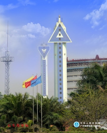
2010 (station established 1956). Active; focal plane 24 m (79 ft); red light, 3 s on, 3 s off, synchronized with the rear light. 29 m (95 ft) hexagonal concrete tower, painted white with a blue vertical stripe on the range line and a large blue and white triangular daymark, point up. A photo is at right and Google has a satellite view. The range guides ships on a northwest reach across Zhànjiāng Bay towards the city's docks. Site status unknown. CN-4742; Admiralty P3379; NGA 20056.
Shítoujiǎo Range Rear (3)
2010 (station established 1956). Active; focal plane 35 m (115 ft); red light, 3 s on, 3 s off, synchronized with the front light. 42 m (138 ft) hexagonal concrete tower, painted white with a blue vertical stripe on the range line and a large blue and white triangular daymark, point down. A photo is at right and Google has a satellite view. Located 540 m (1/3 mi) northwest of the front light. Site status unknown. CN-4743; Admiralty P3379.1; NGA 20060.
Zhànjiāng Pier 205
Date unknown. Active; focal plane 16.5 m (54 ft); quick-flashing red light. 10 m (33 ft) steel and fiberglass tower colored with red and white horizontal bands. No photo available but Google has a satellite view. Located at the south end of pier at the large oil terminal on the south side of downtown Zhànjiāng. Site and tower closed. CN-4744.5; Admiralty P3381.55.

Shítoujiǎo Range Lights, Zhànjiāng
PRC MSA Guǎngdōng Region photo

Mázhāng District: Dōnghǎi Island Lighthouses
Dōnghǎi is a large island southeast of Zhànjiāng; it forms the south side of Zhànjiāng Bay and the north side of Léizhōu Bay.

Dōngtóushān Dǎo Range Front (3?)
Date unknown (station established 1915). Active; focal plane 37 m (121 ft); continuous red light. Approx. 32 m (105 ft) round cylindrical concrete tower, painted white with a red vertical stripe on the range line. No photo but Google has a satellite view. This range guides vessels southbound as they leave the inner harbor of Zhànjiāng. Dōngtóushān is a small island off the north shore of Dōnghǎi Island. Located on the northern point of the island. Site status unknown. CN-4738; Admiralty P3381; NGA 20048.
Dōngtóushān Dǎo Range Rear (3?)
Date unknown (station established 1915). Active; focal plane 43 m (141 ft); continuous red light. Approx. 35 m (115 ft) round cylindrical concrete tower, painted white with a black vertical stripe on the range line. No photo but Google has a satellite view. Located on a hill 250 m (275 yd) south of the front light. Site status unknown. CN-4739; Admiralty P3381.1; NGA 20052.
Lightfloat Dōnghǎi Dǎo
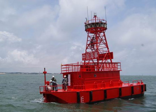
2007. Active; focal plane 10 m (33 ft); two white flashes every 10 s. Steel lightfloat, painted red. The light is shown from a square skeletal tower mounted on a 1-story superstructure amidships. An MSA photo is at right but the ship is not seen in Bing's satellite view. Located about 2.5 km (1.5 mi) east of the northeastern point of Dōnghǎi. Accessible only by boat. Site open, vessel closed. CN-4698.41; Admiralty P3375; NGA 20029.
Lóngténg Hángdào (Bēngtángjiǎo Range Front)
2007. Active (?); focal plane 42 m (138 ft); white, red or green light depending on direction, 2 s on, 2 s off. 44 m (144 ft) round concrete tower mounted on a robust pier. The lighthouse is white with a red vertical stripe on the range line. No photo available but Google has a satellite view. This is the main approach range for Zhànjiāng. Probably endangered, this lighthouse is standing in the surf. The rear light was removed in 2014 and this light was converted to a directional (leading) light at that time. Located just off the beach at Cape Bēngtáng, the south side of the entrance to Zhànjiāng harbor. Site status unknown. CN-4720.2; Admiralty P3372.1; NGA 20014.
#Bēngtángjiǎo Range Rear
2007. Removed in 2014. This was a 59 m (194 ft) round white concrete tower with a large round observation structure below the light; the tower also had a red vertical stripe on the range line. Google's satellite view confirms the disappearance of the lighthouse. Located on a low hill 1.48 km (0.92 mi) west of the front light. Site status unknown. ex-Admiralty P3372.11; ex-NGA 20015.
Donghai Dao Lightfloat
Dōnghǎi Dǎo Lightfloat, Zhànjiāng
PRC MSA Guǎngdōng Region photo
Lóngshuǐ Lǐng (Lóngshuǐlǐng) Range Rear (2)
1989 (station established 1956). Active; focal plane 63 m (207 ft); two white flashes every 4 s. 13.5 m (44 ft) hexagonal concrete tower with gallery, painted white with a black vertical stripe on the range line. No photo available but Google has a good satellite view. This range guides ships past the north side of Náozhōu Island. Located on a hilltop on the east coast of the island of Dōnghǎi, about 25 km (15 mi) southeast of Zhànjiāng. Site status unknown. CN-4718; Admiralty P3368.1; NGA 20020.
* Lóngshuǐ Lǐng (Lóngshuǐlǐng) Range Front (2)
1989 (station established 1956). Active; focal plane 24 m (79 ft); continuous white light. 17 m (56 ft) hexagonal concrete tower with gallery, painted white with a black vertical stripe on the range line. No photo available but Google has a satellite view. Located near the coast, 1088 m (2/3 mi) southeast of the rear light. Site open, tower closed. CN-4717; Admiralty P3368; NGA 20016.

Mázhāng District: Náozhōu Island Lighthouses
Náozhōu is an island about 8 km (5 mi) in diameter on the north side of the entrance to Léizhōu Bay.

Léigòng Lǐng
Date unknown. Active; focal plane unknown; quick-flashing white light. 8 m (26 ft) white stone tower. No photo available but Google has a satellite view. Located on a promontory near the northwest tip of Náozhōu. Site status unknown. CN-4707; Admiralty P3359.9; NGA 20012.06.
Lightship Zhànjiāng Gǎng
Date unknown (2007?). Active; focal plane 11 m (36 ft); white flash every 6 s. Lightship, hull painted red. No photo available and the ship is not seen in Google's satellite view. The ship is in line with both the Lóngshuǐ Lǐng range lights and the Dòulóng West range lights. Located about 3.5 km (2.25 mi) east of the northeastern point of Náozhōu. Accessible only by boat. Site open, vessel closed. CN-4711; Admiralty P3361; ex-NGA 20102.
Náozhōu Dòulóng South Range Front (3)
1989 (station established 1916). Active; focal plane 18 m (56 ft); white light, 2 s on, 2 s off. 13 m (43 ft) hexagonal concrete tower with gallery, painted white. No photo available but Google has a satellite view. This range is called the south range because it is aligned from north to south guiding ships leaving Zhànjiāng. The original light was the front light for a range aligned with the Náozhōu lighthouse. Located near the northeastern point of the island of Náozhōu. Site status unknown. CN-4709.1; Admiralty P3360.4; NGA 20010.
Náozhōu Dòulóng West Range Front (2)
1989 (station established 1956). Active; focal plane 31 m (102 ft); continuous white light. 11 m (36 ft) round cylindrical concrete tower rising from a square concrete base. Lighthouse painted white. No photo available but Google has a satellite view. NGA calls this range the Doulong North Range; it's at the north end of Náozhōu but is aligned to the west. Located near the northeastern point of the island of Náozhōu. Site status unknown. ARLHS PRC-049; CN-4709; Admiralty P3360; NGA 20004.
Náozhōu Dòulóng West Range Rear (2)
1989 (station established 1956). Active; focal plane 44 m (144 ft); white light, 3 s on, 3 s off. 28 m (92 ft) round strongly conical concrete tower with double gallery. Lighthouse painted white with a black vertical stripe on the range line. No photo available but Google has the satellite view seen at right. Located 200 m (220 yd) due west of the front light. Site status unknown. ARLHS PRC-048; CN-4708; Admiralty P3360.1; NGA 20008.
Náozhōu Dòulóng South Range Rear (2)
1989 (station established 1956). Active; focal plane 42 m (138 ft); quick white flash every 1 s. 16 m (52 ft) hexagonal concrete tower with gallery, painted white with a black vertical bar on the range line. No photo available but Google has a satellite view. Located 1.75 km (1.1 mi) south of the front light. CN-4710; Admiralty P3360.41; NGA 20012.

Dòulóng West Range Rear Light, Náozhōu
Google Maps satellite view
*** Náozhōu Dǎo (Nao Chou, Nao-Tchéou) (2)
1904 (station establishment date unknown). Active; focal plane 103 m (338 ft); white flash every 5 s. 19 m (62 ft) round stone tower with lantern and gallery, rising from a square 1-story stone base. The tower is unpainted stone; lantern painted white. This is a staffed station. A 2018 photo is at the top of this page, MSA has an excellent photo, Wikimedia has other photos, tHuelse has a historic postcard view, and Google has a satellite view. This historic lighthouse was built as the landfall light for the French colony of Guǎngzhōuwan (Kwangchowan); according to MSA it replaced an older stone tower. Today it is a well-known tourist attraction of the Zhànjiāng area. Located on heights on the southeast side of the island. Site open, tower status unknown. CN-4700; Admiralty P3359; NGA 20000.
Nánjiǎowèi (South Cape Point)
Date unknown. Active; focal plane 16 m (52 ft); quick-flashing white light. 11 m (36 ft) concrete tower painted red. No photo available but Google has a satellite view. Located at the southern tip of Náozhōu. Site status unknown. CN-4702.05; Admiralty P3359.3; NGA 20012.9.

Information available on lost lighthouses:

Notable faux lighthouses:

Adjoining pages: North: Guǎngdōng South Coast | South: Léizhōu Peninsula

Return to the Lighthouse Directory index | Ratings key

Posted December 17, 2008. Checked and revised April 3, 2024. Lighthouses: 45; lightships: 2. Site copyright 2024 Russ Rowlett and the University of North Carolina at Chapel Hill.