Lighthouses of China: Southwest Guǎngxī

The People's Republic of China (PRC), known officially as Zhōnghuá (中华), has a lengthy coastline, many large harbors, and a large number of lighthouses. The country is divided into 23 provinces and 11 other province-level regions of various special types. Guǎngxī (more properly Guǎngxī Zhuàngzú Zìzhìqū, the Guǎngxī Zhuàng Autonomous Region) is a province-level region of China located in the extreme south of the country adjacent to Vietnam. Historically the Guǎngxī region was landlocked but in 1952 the People's Republic transferred the westernmost coastal portion of Guǎngdōng Province to Guǎngxī. This decison was reversed in 1955 and then reinstated in 1965.

The coastline of Guǎngxī extends for about 200 km (125 mi) along the north end of the Gulf of Tonkin. The Chinese name for the Gulf of Tonkin is Běibù Wān (Northern Bay) because the gulf is the northern extension of the South China Sea. The region is divided into 14 prefectural-level cities; the three bordering the coast are Běihǎi, Qīnzhōu, and Fángchénggǎng. All three include major ports. This page is for lighthouses of Qīnzhōu and Fángchénggǎng; there is a separate page for lighthouses of Běihǎi.

There are many languages and dialects spoken in China, but Standard Chinese, often called Mandarin, is official. The pīnyīn system for transliterating Standard Chinese into Latin characters is now the international standard but some locations continue to be known also under the spellings of older transliteration systems. The Chinese word for a lighthouse is dēngtǎ (灯塔). In Standard Chinese jiāo (formerly chiao) is a reef or rock, jiǎo is a cape or headland, dǎo (tao) is an island; (tsu) or tuózi ("lump") is a small island, hǎi is a sea, wān is a bay, hǎixiá is a strait, or jiāng is a river, hékǒu ("river mouth") is an estuary, and gǎng (kang) is a harbor.

Lighthouses in China are maintained by the PRC Maritime Safety Administration (MSA). The administration is organized in four regional administrations with district offices in the major ports. The lights on this page are maintained by the Zhànjiāng MSA office in Guǎngdōng, which is included in the Guǎngzhōu Region.

ARLHS numbers are from the ARLHS World List of Lights. CN numbers are the serial numbers used by the Shànghǎi regional office of MSA. Admiralty numbers are from volume P of the Admiralty List of Lights & Fog Signals. U.S. NGA List numbers are from Publication 112.

General Sources
Online List of Lights - China - Gulf of Tonkin
Photos by various photographers posted by Alexander Trabas.
Chinese English Pinyin Dictionary
A useful tool for juggling the representations of Chinese names.
GPSNavigationCharts
Navigation chart information for the Gulf of Tonkin.
Navionics Charts
Navigation chart information for Guǎngxī.
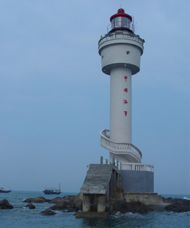
Baixuging Jiao Light
Baixugong Jiao Light, Gulf of Tonkin
PRC Maritime Safety Administration photo
Qīnzhōu Prefecture Lighthouses

Qīnnán District Lighthouses
Shājiǎo ("Sand Point")
Date unknown. Active; focal plane about 12 m (39 ft); white flash every 4 s. Approx. 10 m (33 ft) round white concrete tower. No photo available but Google has a satellite view. Located on the waterfront of Shājiǎo, a port on the west side of the mouth of the Dàfēng River. CN serial 811066; Admiralty P3319.782.
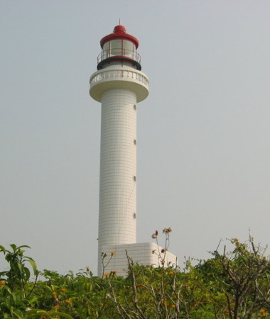
Dàmiàodūn (2)
2005 (station established 1958). Active; focal plane 39 m (128 ft); white flash every 4 s. 21 m (69 ft) round cylindrical concrete tower with lantern and gallery, rising from a 1-story equipment building. A photo is at right and Google has a satellite view of the station. The original lighthouse, an 18.5 m (61 ft) round concrete tower, was replaced because it had become dangerously undermined. The lighthouse marks the eastern entrance to Qīnzhōu Bay (the northernmost embayment of the Gulf of Tonkin). Located on an island about 2 km (1.25 mi) off the point of land at the east side of the entrance to the bay. Accessible only by boat. Site status unknown. CN-4911; Admiralty P3319.78; NGA 20093.5.
Wūléi
Date unknown. Active; focal plane 9.5 m (31 ft); white flash every 4 s. 9 m (30 ft) steel and fiberglass tower colred with red and white horizontal bands. No photo available but Google has an indistinct satellite view. Located on a sandbar about 800 m (1/2 mi) north of the Dàmiàodūn lighthouse. Accessible only by boat. Site status unknown. CN serial 83100101; Admiralty P3319.77.
Píngdūn
Date unknown. Active; focal plane 8 m (23 ft); red flash every 4 s. 12 m (39 ft) round cylindrical concrete tower mounted on a square platform supported by piles. Entire lighthouse is red. No photo available but Google has a fuzzy satellite view. Located on the west side of the entrance channel to the Lù'ěrhuán River, on the east side of Qīnzhōu Bay. Accessible only by boat. Site status unknown. CN-4912; Admiralty P3319.72.
Jísuídùshí
Date unknown. Active; focal plane 9 m (30 ft); white flash every 4 s. 12 m (39 ft) round cylindrical concrete tower mounted on a square platform supported by piles. Entire lighthouse is red. No photo available but Bing has a satellite view. Located on the east side of the entrance channel to the Lù'ěrhuán River, on the east side of Qīnzhōu Bay. Accessible only by boat. Site status unknown. CN-4913; Admiralty P3319.7.
Qīngcáitóu Dǎo
Date unknown. Active; focal plane 25 m (82 ft); white flash every 4 s. 14 m (46 ft) round cylindrical concrete tower with gallery. Entire lighthouse is white. No photo available but Google has a satellite view. Located on a small island on the east side of the entrance to Qīnzhōu Bay. Accessible only by boat. Site status unknown. CN-4923; Admiralty P3319.2; NGA 20093.66.
#Xīshí
Date unknown. Inactive since 2017 and since removed. This was a 6 m (20 ft) round concrete tower, painted red. No photo available and the light has disappeared from Bing's satellite view. Located on a shoal just northeast of Qīngcáitóu Dǎo. Accessible only by boat. Site status unknown. CN-4924; ex-Admiralty P3319.22.
Damiaodun Light
Dàmiàodūn Light, Qīnzhōu
PRC MSA Guǎngdōng Region photo
Xiǎoyāshí ("Little Crow Rock," Qīnzhōu Gǎng) (2)
1997 (station established 1970). Active; focal plane 8 m (26 ft); red flash every 3 s. 8 m (26 ft) round cylindrical concrete tower with gallery, covered with white ceramic tiles. No photo available but Google has a satellite view. Located on a shoal in the south entrance to the passage between Qīnzhōu Bay and Máowěi Bay. Accessible only by boat. Site status unknown. CN-4925; Admiralty P3319.5; NGA 20093.7.
Xiǎngshuǐshí (2)
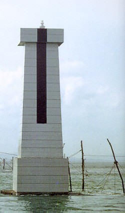
1997 (station established 1969). Active; focal plane 9 m (30 ft); white flash every 3 s. 9 m (30 ft) square concrete tower, covered with white ceramic tiles. the lighthouse also has a black vertical stripe, perhaps indicating that it is the rear light of a range. A photo is at right and Google has an indistinct satellite view. This light and the Dōngguāshí light frame the narrow passage between Qīnzhōu Bay and Máowěi Bay about 5.5 km (3.5 mi) north northwest of the entrance. Located on the east side of the passage. Accessible only by boat. Site status unknown. CN-4935; Admiralty P3319.576.
Hǎiyín Jiāo
Date unknown. Active; focal plane 7 m (23 ft); red flash every 4 s. 13 m (43 ft) round cylindrical concrete tower mounted on a square platform supported by piles. Entire lighthouse is red. No photo available but Bing has a satellite view. Located on a shoal in the north entrance to the passage between Qīnzhōu Bay and Máowěi Bay. Accessible only by boat. Site status unknown. CN-4938; Admiralty P3319.583.

Fángchénggǎng Prefecture Lighthouses

Gǎngkǒu (Harbor) District Lighthouses
Jílíshí (Light #11)
Date unknown. Active; focal plane 13 m (43 ft); green flash every 4 s. 11 m (36 ft) round cylindrical concrete tower mounted on a square platform supported by piles. Entire lighthouse is green. No photo available but Bing has a satellite view. Located on the south side of the entrance to the Máolǐng River, on the west side of Máowěi Bay. Accessible only by boat. Site status unknown. CN-4938.19; Admiralty P3319.6.
#Nándīngpíng
Date unknown. Inactive since 2019 and since removed. 12 m (39 ft) round cylindrical concrete tower mounted on a square platform supported by piles. Entire lighthouse is green. No photo available but Bing has a satellite view. Google's satellite view confirms the removal. Located south of the entrance to the Máolǐng River. Accessible only by boat. Site status unknown. CN-4938.17; ex-Admiralty P3319.602.
Xiangshushi Light
Xiǎngshuǐshí Light, Qīnzhōu
PRC Maritime Safety Administration photo
Qiáoshí Wěi (Light #7)
Date unknown. Active; focal plane 7 m (23 ft); red flash every 4 s. 11 m (36 ft) round cylindrical concrete tower mounted on a square platform supported by piles. Entire lighthouse is red. No photo available but Bing has a satellite view. Located in the southwestern area of Máowěi Bay, near the town of Dàshān'ào. Accessible only by boat. Site status unknown. CN-4938.15; Admiralty P3319.5817.
Jīnshuǐdūn (Light #5)
Date unknown. Active; focal plane 7 m (23 ft); red flash every 4 s. 11 m (36 ft) round cylindrical concrete tower mounted on a square platform supported by piles. Entire lighthouse is red. No photo available but Bing has a satellite view. Located in the southwestern area of Máowěi Bay, near the town of Dàshān'ào. Accessible only by boat. Site status unknown. CN-4938.13; Admiralty P3319.5815.
Dōngguāshí (Dōngshàoshí)
1971 (rebuilt 1997). Active; focal plane 6 m (20 ft); red flash every 3 s. 6 m (20 ft) square pyramidal concrete tower, covered with white ceramic tiles. The tiles were probably added in 1997. No photo available but Bing has a satellite view. Located off the port of Lóngmén on the west side of the narrow passage in Qīnzhōu Bay. Accessible only by boat. Site status unknown. CN-4934; Admiralty P3319.575.
Lóngmén Guīdūn (Lóngmén Turtle Rock)
Date unknown. Active; focal plane 9.5 m (31 ft); white flash every 4 s. 9.5 m (31 ft) tower on a square concrete base. No photo available but Google has a satellite view. Located opposite the waterfront of Lóngmén harbor. Accessible only by boat. Site status unknown. CN serial 8310321.01; Admiralty P3319.5743.
Guānyīntáng
Date unknown. Active; focal plane 7.5 m (25 ft); white flash every 4 s. 7.5 m (25 ft) round fiberglass tower colored with red and white horizontal bands and mounted on a concrete pier. No photo available but Google has a satellite view. Located on the south side of the entrance to Lóngmén harbor. Accessible only by boat. Site status unknown. CN serial 8310321.04; Admiralty P3319.5748.
Xīhǎijiāng Jiāo
Date unknown. Active; focal plane 6 m (20 ft); green flash every 4 s. 6 m (20 ft) round cylindrical concrete tower. No photo available, but Bing has a satellite view. Located on a shoal on the west side of the entrance to Qīnzhōu Bay. Accessible only by boat. Site status unknown. CN-4921; Admiralty P3319.4; NGA 20093.65.
Éméiyuè Shí
Date unknown. Active; focal plane 6 m (20 ft); two white flashes every 6 s. 9 m (30 ft) round stone tower. Entire lighthouse is white. No photo available but Google has a fuzzy satellite view. Located on a shoal off the industrial port of Shílóng on the west side of Qīnzhōu Bay. Accessible only by boat. Site status unknown. CN-4920; Admiralty P3319.3; NGA 20093.6.
Tiàoduò Shí
Date unknown. Active; focal plane 10 m (33 ft); two white flashes evry 10 s. 10 m (33 ft) round white masonry tower. No photo available but Google has a distant satellite view. Located on a shoal on the east side of the entrance to Qǐshā harbor, a small estuary a short distance west of Qīnzhōu Bay. Accessible only by boat. Site status unknown. CN-4942; Admiralty P3316.82; NGA 20093.55.
Pingdūn Shí (Shabadun)
Date unknown. Active; focal plane 9 m (30 ft); white flash evry 4 s. 9 m (33 ft) round white concrete tower. Chi Hin So has a photo (light on the left) and Google has a satellite view. Located just off the end of the east breakwater of Qǐshā harbor. Accessible only by boat. Site status unknown. CN-4941; Admiralty P3316.8; NGA 20093.56.
Jiāngbiān Shí ("Riverbank Rock")
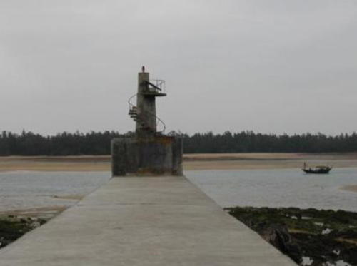
Date unknown. Active; focal plane 9 m (30 ft); red flash every 4 s. 10 m (33 ft) white masonry tower on a large square concrete base; a stairway spirals around the tower. Chi Hin So's photo is at right and Google has a fuzzy satellite view. Located on a short pier on the west side of Qǐshā harbor. Accessible by walking the pier. CN-4940; Admiralty P3316.85.

Jiāngbiān Shí Light, Fángchénggǎng, September 2011
Google Maps photo by Chi Hin So
Qǐshā West Breakwater
Date unknown. Active; focal plane about 15 m (49 ft); red (?) light, pattern unknown. Approx. 12 m (39 ft) tower. Felix Chen hs a 2021 street view and Google has a satellite view. Located near the end of the long west breakwater of Qǐshā harbor. Site status unknown. Not listed by the Admiralty.
Tiāntáng Jiǎo (Paradise Point)
Date unknown. Active; focal plane 35 m (115 ft); whiet flash every 3 s. Approx. 10 m (33 ft) round white stone tower. No photo available but Google has a satellite view. Located on a hilltop on the west side of Qǐshā harbor. Site status unknown. CN-4943; Admiralty P3316.84.
#Fángchénggǎng (Fángchéng Gǎng)
Date unknown. Demolished around 2008-09. This was a 30 m (98 ft) round steel tower with lantern and gallery, painted red with narrow white horizontal bands. Although this light continued to be listed on the 2016 Chinese list, no such tower can be found in Google's satellite view. Formerly located on a prominent ridge on the east side of the entrance to Fángchéng Bay, about 7 km (4 mi) southwest of Qǐshā. Site status unknown. CN-4943.1; Admiralty ex-P3316.2; ex-NGA 20086.
Diàoyútái Dǎo
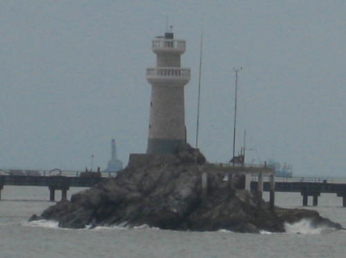
1999. Active; focal plane 16 m (52 ft); white flash every 4 s. 10 m (33 ft) round white concrete tower with double gallery. Chi Hin So's photo is at right and Google has a satellite view. Located on a small island in the entrance to the east basin of Fángchéng harbor. Accessible only by boat. Site status unknown. CN-4946; Admiralty P3316.7.
Fángchén Pier
Date unknown. Active; focal plane 16 m (52 ft); two white flashes every 6 s. 8.5 m (28 ft) white tower. No photo available but Google has a satellite view. Located at the end of a long pier at the tip of the point separating the two branches of Fángchéng Bay. Site and tower closed. CN-4955.3; Admiralty P3316.94.

Diàoyútái Dǎo Light, Fángchénggǎng, September 2011
Google Maps photo by Chi Hin So

Fángchéng District Lighthouses
Lóngkōngdūn (Fángchéng Bay Range Front)
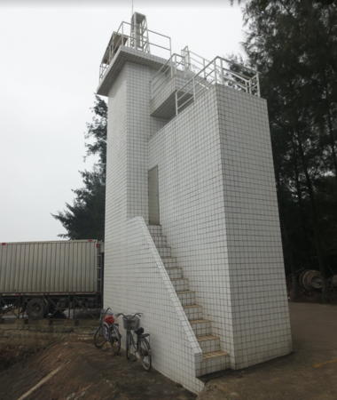
Date unknown. Active; focal plane about 15 m (49 ft); three white flashes every 6 s. 13 m (43 ft) square concrete tower covered with white tile; there is a black vertical stripe on the front. A photo is at right and Google has an indistinct satellite view. Located on the eastern tip of a small island in the center of Fángchéng Bay. Accessible only by boat. Site status unknown. CN-4961.1; Admiralty P3317.9.
Shíwūmén (Fángchéng Bay Range Rear)
Date unknown. Active; focal plane about 22 m (72 ft); continuous white light. 18 m (59 ft) square concrete tower covered with white tile; there is a black vertical stripe on the front. No photo available but Google has an indistinct satellite view. Located on an islet or pier 389 m (425 yd) northeast of the front light. Accessible only by boat. Site status unknown. CN-4961.11; Admiralty P3317.91.
Mǎ'ān Lǐng (Mǎ'ān Tóu, Mǎ'ān Head) Range Front
Date unknown. Active; focal plane 10 m (33 ft); three white flashes every 6 s. 10 m (33 ft) white masonry tower. No photo available and the light is not shown in Google's satellite view. This range guides vessels northward through Fángchéng harbor, an inlet west of Qīnzhōu Bay. Located offshore about 300 m (0.2 mi) southeast of the rear light. Accessible only by boat. Site status unknown. CN-4960; Admiralty P3318.4.
Mǎ'ān Lǐng (Mǎ'ān Tóu, Mǎ'ān Head) Range Rear
Date unknown. Active; focal plane 16.5 m (54 ft); continuous white light. Approx. 12 m (33 ft) square white masonry tower. No photo available but Google has a satellite view. Located on the side of a prominent headland on the west side of the harbor. Site status unknown. CN-4961; Admiralty P3318.41.
Xīxiàn Hángdǎo Range Front
Date unknown. Active; focal plane 12 m (39 ft); three white flashes every 6 s. Approx. 14 m (46 ft) white tower with a black vertical stripe. No photo available but Google has an indistinct satellite view. This is an approach range for Fángchéng harbor. Located on a pier about 500 m (0.3 mi) off the west side of Fángchéng Bay. Accessible only by boat. Site status unknown. CN-4958; Admiralty P3317.4.
Xīxiàn Hángdǎo Range Rear
Date unknown. Active; focal plane 20 m (66 ft); three white flashes every 6 s. Approx. 12 m (39 ft) white tower with a black vertical stripe. No photo available but Google has an indistinct satellite view. Located about 800 m (0.5 mi) northwest of the front light. Accessible only by boat. Site status unknown. CN-4959; Admiralty P3317.41.
 

Lóngkōngdūn Light, Fángchéng, May 2014
Google Maps photo by 海狼王
 
Sānyàshí (2)
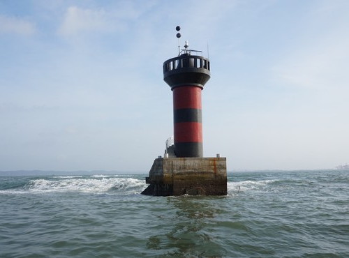
Date unknown (station establishment date unknown). Active; focal plane 11 m (36 ft); two white flashes every 5 s. 13 m (43 ft) round cylindrical concrete tower with gallery colored with red and black horizontal bands. A photo is at right but the light is hard to see in Google's indistinct satellite view. The original light was described as a 6 m (20 ft) "white stone pile." Located on a shoal southwest of the entrance to Fángchéng Bay. Accessible only by boat. Site status unknown. CN-4964; Admiralty P3316.3; NGA 20213.
Xiǎoshuāngshí (2)
Date unknown (station establishment date unknown). Active; focal plane 10 m (33 ft); two white flashes every 5 s. 12 m (39 ft) round cylindrical concrete tower with gallery colored with red and black horizontal bands. No photo available but Google has a distant satellite view. The earlier light was described as a 6 m (20 ft) square white stone tower. Located on a shoal in the entrance to Zhěnzhū Bay. Accessible only by boat. Site status unknown. CN-4966; Admiralty P3316.13.
Wànōu (1)
Date unknown. Active (?); focal plane 32 m (105 ft); white flash every 3 s. 10 m (33 ft) round white tower, apparently a radar tower. A distant view is available and Google has a fuzzy satellite view. Located on a bluff in Wànōu on the east side of the Báilóng Peninsula about 16 km (10 mi) northeast of the Báilóngwěi lighthouse. Site status unknown. CN-4965; not listed by the Admiralty.
Wànōu (2)
Date unknown. Active; focal plane 10 m (33 ft); white flash every 3 s. 10 m (33 ft) white masonry tower mounted on a square concrete pier. No photo available but Google has a fuzzy satellite view. Located about 200 m (220 yd) off the beach on the south side of the Báilóng Peninsula about 1 km (0.6 mi) east northeast of the Wànōu light in the CN list (previous entry). Accessible only by boat. Site status unknown. Admiralty P3316.22.
Sanyashi Light
Sanyashi Light, Fángchénggǎng
PRC South China Sea Maritime Security Center photo
Báilóngwěi (Báilóng Wěi, White Dragon Point)
Date unknown (station established 1966). Active; focal plane 90 m (296 ft); white flash every 4 s. 20 m (66 ft) round cylindrical concrete tower with lantern and gallery. The lighthouse is white, lantern roof red. Google has a satellite view and a distant street view. The original light had a focal plane height of 79 m (259 ft). Built to mark the border with Vietnam, this lighthouse is located at the end of the Báilóng Peninsula overlooking the border. Site status unknown. CN-4971; Admiralty P3316.1; NGA 20095.
Jīn Tán
Date unknown (recent). Active; focal plane about 12 m (39 ft); white light, pattern unknown. Approx. 12 m (39 ft) barbell-shaped tower on a square concrete base. No photo available but Google has a satellite view. Located on the cape at the east side of the entrnce to Běilún Bay, which is on the Vietnamese border. Site status unknown. Admiralty P3316.03.
Báixūgōng Jiāo (Baisuyan) (2)
1972. Active; focal plane 23 m (75 ft); white flash every 4 s. 19 m (62 ft) round white concrete tower. A photo is at the top of this page but the lighthouse is not seen in Google's satellite view. The original light was a 12.5 m (41 ft) square pyramidal concrete tower. Located on a shoal in the Gulf of Tonkin, marking the maritime border with Vietnam about 25 km (15 mi) southeast of the mainland coast. Accessible only by boat. Site status unknown. CN-4970; Admiralty P3316; NGA 20215.

Information available on lost lighthouses:

Notable faux lighthouses:

Adjoining pages: East: Běihǎi | South: Northern Vietnam

Return to the Lighthouse Directory index | Ratings key

Posted December 19, 2008. Checked and revised April 23, 2024. Lighthouses: 40. Site copyright 2024 Russ Rowlett and the University of North Carolina at Chapel Hill.