Lighthouses of China: Pǔtúo District (Eastern Zhōushān), Zhèjiāng

The People's Republic of China (中华, Zhōnghuá in Chinese) has a lengthy coastline, many large harbors, and a large number of lighthouses. The country is divided into 23 provinces and 11 other province-level regions of various special types. The Chinese province of Zhèjiāng (formerly spelled Chekiang) occupies the central coast of the country, south of Shànghǎi and north of the Formosa Strait. The province faces east on the East China Sea. For the most part the coastline is hilly and irregular, with more than 3000 islands of all sizes offshore.

Hángzhōu Bay is a large embayment at the northern end of the province. Spread across the mouth of Hángzhōu Bay, the Zhōushān Islands include well over 1000 islands, although only 103 are large enough to be inhabited. Lighting this maze of islands requires hundreds of beacons of all sizes. This page covers lighthouses of the Pǔtuó District of the prefectural city of Zhōushān; the district includes the eastern end of Zhōushān Island, Pǔtuó Island, and a large number of islands to the northeast and southeast of Pǔtuó.

There are many languages and dialects spoken in China, but Standard Chinese, often called Mandarin, is official. The pīnyīn system for transliterating Standard Chinese into Latin characters is now the international standard but some locations continue to be known also under the spellings of older transliteration systems. The Chinese word for a lighthouse is dēngtǎ (灯塔). In Standard Chinese jiāo (formerly chiao) is a reef or rock, jiǎo is a cape or headland, dǎo (tao) is an island; (tsu) or tuózi ("lump") is a small island, hǎi is a sea, wān is a bay, hǎixiá is a strait, or jiāng is a river, hékǒu ("river mouth") is an estuary, and gǎng (kang) is a harbor.

Lighthouses in China are maintained by the PRC Maritime Safety Administration. The administration is organized in four regional administrations, with offices in the major ports. All the lights on this page are maintained by the Zhènhǎi MSA office.

ARLHS numbers are from the ARLHS World List of Lights. CN numbers are Chinese light list numbers. Admiralty numbers are from volume P of the Admiralty List of Lights & Fog Signals. U.S. NGA List numbers are from Publication 112.

General Sources
Online List of Lights - China
Photos by various photographers posted by Alexander Trabas.
Chinese English Pinyin Dictionary
A useful tool for juggling the representations of Chinese names.
Navionics Charts
Navigation chart for Zhèjiāng.

Luojiashan Light
Luòjiāshān Light, Pǔtúoshān
Zhèjiāng Culture Ministry photo (no longer online)
Zhōngjiēshān Islands Lighthouses
These islands lie at the eastern end of the same chain that includes Dàishāndǎo and Chángtúshāndǎo. However, these islands are not in Dàishān County but are attached administratively to Pǔtuó District.

Liǎngxiōngdìyǔ (Liǎngxiōngdì Yǔ, Two Brothers Reef)
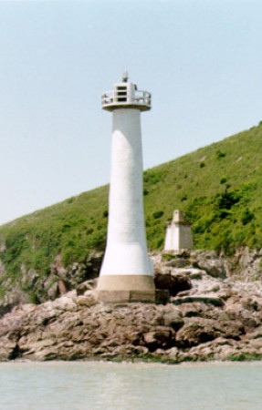
2007. Active; focal plane 32 m (105 ft); white flash every 2 s. 14 m (46 ft) round concrete tower with lantern and gallery, painted white. An MSA photo is at right. This new lighthouse marks a reef known as the "Two Brothers," located at the extreme eastern end of the Dàishān chain. It is one of several lighthouses built by China in recent years to mark its maritime frontier. No photo available but Bin has a satellite view. Site status unknown. CN-2378.01, Admiralty P3719.8; NGA 18902.5.
Dōngfúshān Xīběi (Dōngfú Shān Northwest) (2)
Date unknown. Active; focal plane 24 m (79 ft); white flash every 4 s. 10 m (33 ft) round cylindrical white concrete tower with gallery. Marco Huang has a 2018 photo and Google has a satellite view. The earlier light was on a skeletal tower. Located on an islet off the northwestern tip of Dōngfúshān. Accessible only by boat. Site open, tower closed. CN-2377.7; Admiralty P3724; NGA 18903.
Xīfúshān Nán (Xifushan South)
Date unknown. Active; focal plane 12 m (39 ft); four white flashes every 12 s. 10 m (33 ft) round cylindrical concrete tower with gallery painted with black and white horizontal bands. No photo available and Google has only an indistinct satellite view. Located on the southwestern tip of Xīfúshān, an island about 8 km (5 mi) northwest of Dōngfúshān. Accessible only by boat. Site open, tower closed. CN-2377.6; Admiralty P3723; NGA 18903.1.
Běipúdǎo
Date unknown. Active; focal plane 16.5 m (54 ft); white flash every 3 s. 10 m (33 ft) round concrete tower painted with black and white horizontal bands. Clement Wang has a distant drone view and Google has a satellite view. Located on a small island off the east side of Miàozihúdǎo. Accessible only by boat. Site open, tower closed. CN-2377.5; Admiralty P3721.8.
Miàozihúdǎo Nán (Miàozihú Dǎo South)
Date unknown. Active; focal plane 15 m (49 ft); white flash every 6 s. 8.5 m (28 ft) round concrete tower painted with red and white horizontal bands. Clement Wang has a distant drone view and Google has a satellite view. Located at the southern tip of Miàozihú, which appears to be the most populous island of the group. Site open, tower closed. CN-2377.3; Admiralty P3721.5.

Liǎngxiōngdìyǔ Light, Zhōngjiēshān Islands, 2007
PRC MSA East China Sea Navigation Center photo
Xiǎoqīngshān (Xiǎoqīng Shan, Little Castle Reef)
Date unknown. Active; focal plane 13 m (43 ft); red flash every 4 s. 10 m (33 ft) round concrete tower with gallery, colored with red and white horizontal bands. No photo available but Google has a satellite view. Located on a skerry off the west coast of Xiǎoqingdǎo, marking a deep passage between islands in the chain. Accessible only by boat. Site open, tower closed. CN-2375.3; Admiralty P3720.3; NGA 18903.7.

Northeast Coast Zhōushān Island Lighthouses
Only the east end of Zhōushān Island is in the Pǔtúo District; most of the island is in the Dìnghǎi District of Zhōushān City. See the Dìnghǎi District page for lighthouses of that area.
Huángtāshān (Huángtā Shān) (2)
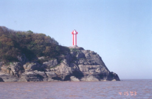
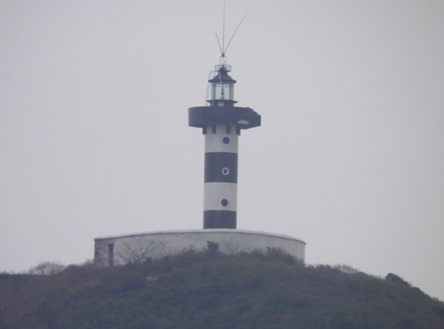
2003 (station establishment date unknown). Active; focal plane 34 m (112 ft); four flashes every 10 s, white or red depending on direction. 11.5 m (38 ft) round cylindrical concrete tower with gallery, covered with ceramic tile colored in red and white vertical stripes. A distant view is at right and Google has a satellite view. This light guides vessels approaching the strait between Zhōushān and Putuoshan Islands. Located at the south end of an island about 4 km (2.5 mi) off the northeastern tip of Zhōushān Island. Accessible only by boat. Site status unknown. CN-2381; Admiralty P3714.007.
Tóngjiāo (Zhōushān Tóng Jiāo, Copper Reef) (2?)
2006. Active; focal plane 11.5 m (38 ft); white flash every 2 s. 7.5 m (25 ft) round cylindrical white concrete tower with gallery. No photo available but Bing has a satellite view. Located on a reef roughly midway between the Huangtashan and Lǐhuòyǔ lights. Accessible only by boat. Site status unknown. CN-2381.5 Admiralty P3714.0035.
Qíjìshān
Date unknown. Active; focal plane 8 m (26 ft); three white flashes every 10 s. 7.5 m (25 ft) round cylindrical white concrete tower with gallery. No photo available but Google has a satellite view. Located on a reef roughly 5 km (3 mi) southeast of the Huángtāshān light. Accessible only by boat. Site status unknown. CN-2381.7 Admiralty P3714.008; NGA 18938.
Shālǐzuǐ
Date unknown. Active; focal plane 12.5 m (41 ft); two white flashes every 4 s. 7.5 m (25 ft) round cylindrical concrete tower with red and white horizontal bands. No photo available but Google has a distant satellite view. Located on a promontoary roughly 5 km (3 mi) south of the Shālǐzuǐ light. Site status unknown. CN-2382.15 Admiralty P3714.009.
Huangtashan Light
Huangtashan Light, April 2003
PRC Maritime Safety Administration Shànghǎi Region photo

Zhōushān Harbor: East Entrance Lighthouses
Shuǐlǎoshǔwěibā (2)
1961 (station established 1953). Active; focal plane 17 m (56 ft); two white flashes every 5 s. 16.5 m (54 ft) hexagonal cylindrical concrete tower with gallery. Lighthouse painted green with a red horizontal band. Rooony Yao has a distant street view and Google has a satellite view. Located on an islet a short distance south of Lǔjiāzhì, an island off the southeast corner of Zhōushān. Accessible only by boat. Site status unknown. CN-2395; Admiralty P3714.02; NGA 18955.
Héshàngjiāo (Héshàng Jiāo) (2)
2003 (station establishment date unknown). Active; focal plane 11.5 m (38 ft); three quick white flashes every 10 s. 10.5 m (35 ft) round cylindrical concrete tower with gallery, mounted on a round concrete pier. Lighthouse covered with tiles, colored black with one yellow horizontal band; pier painted black. No photo available but Google has a satellite view. Located on a reef on the south side of the east entrance to Zhōushān harbor. Accessible only by boat. Site and tower closed. CN 2390; Admiralty P3714.025.
Wàiyuánshān (Wàiyuán Shān)
1990 (station establishment date unknown). Active; focal plane 20 m (66 ft); white flash every 6 s. 8 m (26 ft) round cylindrical white concrete tower with gallery. No photo available but Google has a satellite view. Located on an islet close offshore east of Zhōushān harbor. Accessible only by boat. Site status unknown. CN-2476; Admiralty P3714.06.

Pǔtúoshān Lighthouse
Pǔtúoshān is an island about 15 km (9 mi) in diameter located just east of Zhōushān Island. The island is one of the four sacred mountains of Chinese Buddhism and is famous for its Buddhist shrines. Zhūjiājiān is a larger island south of Pǔtúoshān.

* Pǔtúoshān (Pu-to Shan) (3)
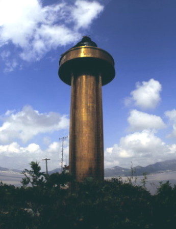
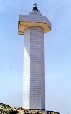
Date unknown (station established 1952). Active; focal plane 74 m (243 ft); white flash every 4 s. 18 m (59 ft) round cylindrical concrete tower with lantern and gallery. The lighthouse is covered with tiles in a deep gold color. The present lighthouse must have been built after 1999. An MSA photo is at right, Ning Zhang has a photo, a more distant view is available, Jiǎng Bīn has a view from the sea, and Google has a satellite view. Located at the southwestern tip of Pǔtúoshān. Accessible by a hiking trail. Site open, tower closed. CN-2384; Admiralty P3714.148; NGA 18954.
Putuoshan Light
Pǔtúoshān Light
PRC MSA Zhènhǎi Office photo (no longer online)

Eastern Pǔtúoshān and Zhūjiājiān Area Lighthouses
Wàihuòyǔ (Waihuò Yǔ)
Date unknown. Active; focal plane 57 m (187 ft); three white flashes, in a 2+1 pattern, every 6 s. 12 m (39 ft) hexagonal cylindrical concrete tower with gallery, covered with tiles colored in red and white vertical stripes. No photo available but Google has a distant satellite view. Located on an islet about 8 km (5 mi) northeast of the northern point of Pǔtúoshān. Accessible only by boat. Site status unknown. CN-2382.1; Admiralty P3714.001.
Lǐhuòyǔ
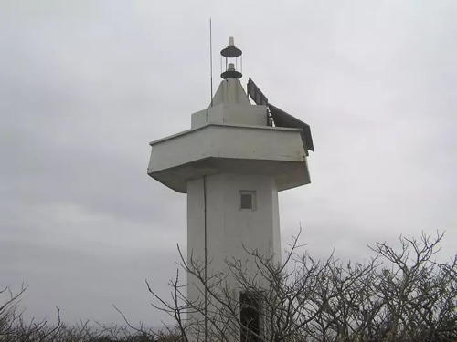
Date unknown. Active; focal plane about 18 m (59 ft); white light, pattern unknown. 7 m (23 ft) hexagonal cylindrical white concrete tower with gallery. An MSA photo is at right and Google has a satellite view. Located on an islet about 8 km (5 mi) northeast of Pǔtúoshān. Accessible only by boat. Site status unknown. CN-2379; Admiralty P3714.004.
Luòjiāshān (Lo-chia Shan, Loka Island)
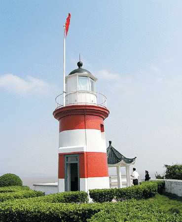
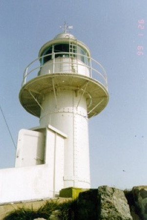
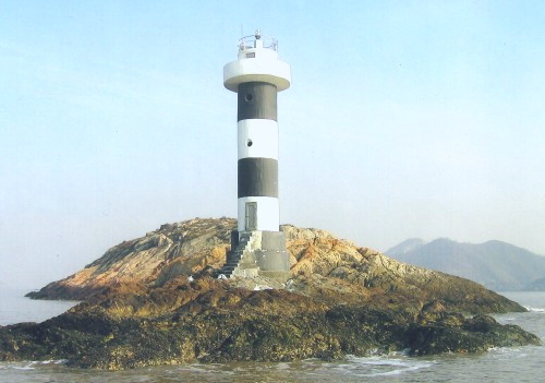
1890 (British). Active; focal plane 40 m (131 ft); three flashes every 9 s, white or red depending on direction. 7 m (23 ft) round stone tower, painted with red and white horizontal bands. Numerous coast guard station buildings; this is a staffed station. A photo is at the top of this page, a travel site has several photos, and Google has a satellite view of the station. In 2011 the light station was listed as a national historic site by the PRC Cultural Heritage Administration. Luòjiāshān is a small island off the northeastern tip of Zhūjiājiān; it is well known for a historic Buddhist shrine. Located at the northeastern tip of the island. Accessible only by boat, although it appears that transportation from Pǔtúoshān is available. Site status unknown. ARLHS PRC-040; CN-2385; Admiralty P3714; NGA 18932.
Chuánjiāo (Chuán Jiāo)
Date unknown. Active; focal plane 13 m (43 ft); four white flashes every 12 s. 8 m (26 ft) round cylindrical white concrete tower. No photo available and the reef is barely visible in Google's very distant satellite view. Located on a reef about 8 km (5 mi) east of Luòjiāshān. Accessible only by boat. CN 2382.2; Admiralty P3713; NGA 18933.

Lǐhuòyǔ Light, Pǔtúoshān
PRC MSA East China Sea Navigation Center photo
Dōngtíngshān (Wàiyángāndǎo, Tung-ting Tao)
1907. Active; focal plane 55 m (180 ft); white flash every 10 s. 8.5 m (28 ft) round cast iron tower with lantern and gallery, painted white. Shànghǎi MSA's closeup photo is at right and Bing has an indistinct satellite view. Dōngtíngshān is a small island in the East China Sea about 25 km (15 mi) east southeast of Zhūjiājiān. Located on the highest point of the island. Accessible only by boat, and landing is difficult. Site and tower closed. ARLHS PRC-028; CN-2397; Admiralty P3712; NGA 18936.
Lǐyángāndǎo (Běitíngshān, Liyang'an Dǎo)
Date unknown. Active; focal plane 51 m (167 ft); white flash every 4 s. Approx. 7 m (23 ft) white concrete tower. No photo available but Google has a satellite view. Located on a rocky islet halfway between Zhūjiājiān and Dōngtíngshān. Accessible only by boat. CN 2397.2; Admiralty P3711; NGA 18935.
Shàngpánjiāo (Shàngpán Jiāo)
Date unknown. Active; focal plane 27 m (89 ft); two flashes every 6 s, white or red depending on direction. Approx. 7 m (23 ft) white concrete tower. No photo available but Bing has a satellite view. The Admiralty is listing this light with a tower height of only 3 m (10 ft), which is inconsistent with the satellite view. It is possible that a new, shorter light was installed here. Located on a rocky islet about 3 km (2 mi) off the southeastern tip of Zhūjiājiān. Accessible only by boat. CN-2399; Admiralty P3710.

Southern Zhūjiājiān Area Lighthouses
Qīngshānjiǎo (Green Hills Point)
Date unknown. Active; focal plane 15 m (49 ft); three quick white flashes every 8 s. 9.5 m (31 ft) round concrete tower painted yellow with one black horizontal band. No photo available but Bing has a distant satellite view. Located on a rocky reef just off the southeastern tip of Zhūjiājiān. Accessible only by boat. Site status unknown. CN-2399.3; Admiralty P3714.147.
Tóngpánshān (Tóngpán Shān) (2)
1988 (station establishment date unknown). Active; focal plane 73 m (240 ft); white flash every 4 s. 10 m (33 ft) round concrete tower with gallery, covered with white ceramic tile. No photo available but Google has a satellite view. Located on a small island off the southern tip of Zhūjiājiān. Accessible only by boat. Site status unknown. CN-2400; Admiralty P3714.145.
Gāngpánjiāo (Gāngpán Jiāo)
Date unknown. Active; focal plane 16 m (52 ft); two red flashes every 6 s. 7 m (23 ft) round concrete tower. Entire lighthouse is red. No photo available but Bing has a satellite view. Located on a shoal off the southern tip of Pǔtúoshān. Accessible only by boat. Site open, tower closed. CN-2385.4; Admiralty P3714.015; NGA 18955.5.
Dongtingshan Light
Dōngtíngshān Light, January 1999
PRC MSA Shànghǎi Region photo
Fēnshuǐjiāo (Fēnshuǐ Jiāo, Shenjia Men) (3)
2007 (station established 1952). Active; focal plane 18 m (59 ft); nine very quick white flashes every 10 s. 12 m (39 ft) slender round concrete tower with gallery and a narrow lantern. Lighthouse painted yellow with a black horizontal band. No photo available but Google has a satellite view. This light warns ships away from the large square concrete pier that supports a tall skeletal tower carrying electric power lines across the narrow strait separating Zhōushān and Zhūjiājiān Islands. The lines cross the strait at its narrowest point, about 1200 m (3/4 mi) across. Located on the northwest corner of the pier, in the middle of the strait. Accessible only by boat. Site status unknown. CN-2388; Admiralty P3714.01.

Dēngbùdǎo Area Lighthouses
Dēngbùdǎo is an inhabited island about 8 km (5 mi) long and 5 km (3 mi) wide located southwest of Zhūjiājiān and southeast of Zhōushān. In October 1949 the island was the scene of an important battle in which the People's Libration Army defeated Nationalist forces occupying the Zhōushān Islands.

Tóngqiánjiāo (Fúlìménshuǐ Dàonán, Fulimenshuidǎo, Fulimen Shuidǎo) (2)
1986 (station established 1964). Active; focal plane 12 m (39 ft); red flash every 4 s. 12 m (39 ft) octagonal concrete tower, painted white according to current lists, although an MSA photo (no longer online) showed the upper half painted black with a yellow horizontal band. No photo available but Google has a satellite view. Located on a reef in the center of the southern entrance to the passage between Zhūjiājiān and Dēngbùdǎo. Accessible only by boat. Site status unknown. CN-2398; Admiralty P3714.143; NGA 18937.
Diǎndēngshān (Diǎndēng Shān) (2)
1990 (station establishment date unknown). Active; focal plane 25 m (82 ft); two white flashes every 6 s. 8 m (26 ft) round concrete tower with gallery, painted white. No photo available but Google has a satellite view. Located on a small island in the center of the sound northwest of Dēngbùdǎo and southeast of Zhōushān. Accessible only by boat. Site status unknown. CN 2478; Admiralty P3714.21; NGA 18953.5.
Dōngshǎndǎo (Dōngshǎn Dǎo, Dongxuan Shan) (3)
1994 (station established 1953). Active; focal plane 23 m (75 ft); white flash every 6 s. 9 m (30 ft) hexagonal cylindrical concrete tower with gallery, covered with white ceramic tile. No photo available but Google has a satellite view. Located at the northeastern tip of an island in the passage between Pǔtúoshān and Dēngbùdǎo. Accessible only by boat. Site status unknown. CN-2396; Admiralty P3714.141.

Táohuādǎo Channel Lighthouses
Táohuādǎo is an inhabited island about 12 km (7.5 mi) long located southwest of Dēngbùdǎo and about 8 km (5 mi) southeast of Cape Ketow, the easternmost point of the mainland south of Zhōushān. The name means "Peach Blossom Island." The main approach to Zhōushān from the Pacific is along the southwest coast of Táohuādǎo; the lights in this group guide ships in that channel.

Táohuādǎo (Táohuā Dǎo) (2)
1997 (station established 1969). Active; focal plane 111 m (364 ft); three white flashes every 12 s. 20 m (66 ft) round cylindrical concrete tower with lantern and gallery, painted with black and white horizontal bands. A photo is at right and Google has a satellite view. The lighthouse is located on the southern tip of Táohuādǎo. Site status unknown. CN-2482; Admiralty P3714.14; NGA 18940.
Xiǎoshuāngshān (Xiǎoshuāng Shān) (2)
1997 (station established 1977). Active; focal plane 17.5 m (57 ft); two white flashes every 6 s. 15.5 m (51 ft) hexagonal cylindrical concrete tower with gallery, rising from a square pyramidal concrete base. Lighthouse covered with ceramic times and colored with red and white vertical stripes. Rogelio Jr. Laura has a 2022 view from the sea and Google has a satellite view. Located at the southeast end of the island of Xiaoshuongshan, off the southwest coast of Táohuādǎo. Accessible only by boat. Site status unknown. CN-2480; Admiralty P3714.16; NGA 18944.

Táohuādǎo Light, Táohuādǎo
PRC MSA Níngbō Office photo
Xiàlánshān (Xiàlán Shān) (3)
1997 (station established 1954). Active; focal plane 20 m (66 ft); white flash every 4 s. 15.5 m (51 ft) hexagonal cylindrical concrete tower with gallery, rising from a square pyramidal concrete base. Lighthouse covered with ceramic times and colored with black and white vertical stripes. Lightphotos.net has a photo by Knut Helge Schistad, Rogelio Jr. Laura has a 2022 photo, and Google has a satellite view. Located at the north end of the island of Xiàlánshān, off the southwest coast of Táohuādǎo. Accessible only by boat. Site status unknown. CN-2479; Admiralty P3714.18; NGA 18948.
Liūwǎngzhòng (Liuwang Shan) (2)
1967 (station established 1952). Active; focal plane 16 m (52 ft); white flash every 6 s. 14.5 m (47 ft) round concrete tower with gallery, painted white. The MSA photo is at right; the small tower in the photo is presumably the original light. Zhang Rongtian has a distant view from the sea 9light on the far right) and Google has a satellite view. NGA lists the light as Shangliuwangzhong Dao. Located on an island off the northwestern tip of Táohuādǎo. Accessible only by boat. Site status unknown. CN-2475; Admiralty P3714.2; NGA 18952.

Dàqiánméndǎo Area Lighthouses
Dàqiánméndǎo is an island about 6 km (3.6 mi) southwest of the northwestern tip of Táohuādǎo. Lights in this group guide vessels into Tóuyáng Harbor, a sound on the north side of Liùhéngdǎo.

Dàqiánméndǎo (Xībáiliánshān, Bailianshan West) (2)
2009 (station establishment date unknown). Active; focal plane 18 m (59 ft); three green flashes every 10 s. 18 m (58 ft) round cylindrical concrete tower. Upper half of the lighthouse painted green, lower half white. No photo available but Google has a satellite view of the location. This light marks an important channel junction between Táohuādǎo and Liùhéngdǎo. Located on a small island off the western tip of Dàqiánméndǎo, about 8 km (5 mi) west of Táohuādǎo. Accessible only by boat. Site status unknown. CN-2472.1; Admiralty P3714.201.
Wàijiāobēidǎo
Date unknown. Active; focal plane 22 m (72 ft); white flash every 6 s. 10 m (33 ft) round cylindrical concrete tower with gallery, covered with white ceramic tiles. No photo available but Google has a satellite view. Located on a small island in Tóuyáng Harbor off the south side of Dàqiánméndǎo. Accessible only by boat. Site status unknown. CN-2531.65; Admiralty P3714.2015.
Duìluǎnshān
Date unknown. Active; focal plane 18 m (59 ft); green flash every 2 s. 10 m (33 ft) round cylindrical concrete tower with gallery, covered with tiles colored with green and white horizontal bands. No photo available but Google has a satellite view. Located on a small island off the southwest side of Dàqiánméndǎo. Accessible only by boat. Site status unknown. CN-2531.6; Admiralty P3714.202.
Liuwangshan
Liūwǎngzhòng Light, Táohuādǎo
PRC MSA Shànghǎi Region photo

Liùhéngdǎo East Coast Lighthouses
Liùhéngdǎo (Liuheng Dǎo) is an inhabited island roughly 25 km (15 mi) long and 10 km (6 mi) wide, lying southwest of Táohuādǎo.
Fūrénshān (Làitóushān) (2)
2009 (station establishment date unknown). Active; focal plane 34 m (112 ft); two red flashes every 6 s. 16 m (52 ft) round cylindrical concrete tower, painted with red and white horizontal bands. No photo available but Google has a satellite view. The former light was on a 7 m (23 ft) post. Located on an islet in Tóuyáng Harbor off the northeast coast of Liùhéngdǎo. Accessible only by boat. Site status unknown. CN-2532.01; Admiralty P3714.208.
Wàimàoshí (2) (?)
2003 (station establishment date unknown). Active; focal plane 11 m (36 ft); three white flashes every 10 s. 9 m (30 ft) round concrete tower with gallery, covered with white ceramic tiles. No photo available but Google has a satellite view. Located on a former islet, now incoporated into a dike on the northern coast of Liùhéngdǎo. Site status unknown. CN-2538; Admiralty P3693.4.
Liángtán Fēnshuǐjiāo
Date unknown. Active; focal plane 9 m (30 ft); two white flashes every 5 s. 9 m (30 ft) round white concrete tower. No photo available but Google has a distant satellite view. Located off the western tip of Liángtándǎo, marking the entrance to a narrow channel between that island and Liùhéngdǎo. Accessible only by boat. Site status unknown. CN-2538.425; Admiralty P3693.3.
Xiǎohuángjiāo
Date unknown. Active; focal plane 10 m (30 ft); red flash every 4 s. 10 m (33 ft) round concrete tower painted with red and whote horizontal bands. No photo available but Google has a satellite view. Located on a shoal off the eastern end of Liángtándǎo. Accessible only by boat. Site status unknown. CN-2531.41; Admiralty P3714.1853.
Dàtóngpándǎo (Dàtóngpán Dǎo) (2)
2003 (station establishment date unknown). Active; focal plane 31.5 m (103 ft); four white flashes every 10 s. 8 m (26 ft) round concrete tower with gallery, covered with white ceramic tiles, mounted atop a large building. Park In-jun has a distant view and Google has a satellite view. Located on an islet just off the eastern end of Liùhéngdǎo. Site status unknown. CN-2539; Admiralty P3693.45.
Duìmiànshān (Duìmiàn Shān, Opposite Hill)
Date unknown. Active; focal plane 69 m (226 ft); white flash every 4 s. 6 m (20 ft) square stone tower, painted white. This little tower seems to be a rare survivor of lights common on the Chinese coast in the 1960s. No photo available and the light is barely visible in Google's distant satellite view. Located on the highest point of Duìmiànshān, an island off the southeastern tip of Liùhéngdǎo. Site status unknown. CN-2541; Admiralty P3693.48.
Waijiao Light
Wàijiāo Light
PRC MSA Shànghǎi Region photo

Waijiao and Bǐjiàshān Lighthouses
These lights face the East China Sea southeast of Liùhéngdǎo.

Wàijiāo (Outside Reef)
Date unknown. Active; focal plane 28 m (92 ft); two white flashes every 6 s. 15.5 m (51 ft) hexagonal cylindrical concrete tower with gallery, covered with white ceramic tiles. This lighthouse marks the start of the passage around the north side of Liùhéngdǎo. An MSA photo is above right and Google has a satellite view. NGA lists this light as Xiangshan Gang. Located on a low, rocky island off the eastern tip of Yuánshāndǎo, about 6 km (3.5 mi) east of the eastern tip of Liùhéngdǎo. Accessible only by boat. Site status unknown. CN-2540; Admiralty P3714.1; NGA 18977.1.
Bǐjiàshān (Bǐjià Shān, Pi-chia Shan)
Date unknown. Active; focal plane 117 m (384 ft); three white flashes every 10 s. 10 m (33 ft) round concrete tower with gallery, covered with white ceramic tiles. Bǐjiàshān is a small but high island about 5 km (3 mi) southeast of the southeastern tip of Liùhéngdǎo. No photo available but Google has a distant satellite view. Located on the heights at the southeastern end of the island. Accessible only by boat. Site status unknown. CN-2542; Admiralty P3693.5.
Xiéxuàntóu
2006. Active; focal plane 17 m (56 ft); white flash every 2 s. 13 m (43 ft) round cylindrical concrete tower with gallery, painted with black and white horizontal bands. Zhènhǎi MSA's photo is at right and Google has a satellite view. This light and the next two guide ships approaching Xiàngshān Bay. Located on a small island about 8 km (5 mi) south of Liùhéng island and 20 km (13 mi) east of the northeastern end of the Xiàngshān Peninsula. Accessible only by boat. Site open, tower closed. CN-2572.6; Admiralty P3690.5.
Xīmòpánjiāo (Xīmòpán Jiāo, Ximoban, Hsi-mo-pan)
Date unknown. Active; focal plane 21 m (69 ft); white flash every 4 s. 10.5 m (35 ft) round stone tower with gallery, covered with white ceramic tiles. No photo available and Google has only a very distant view of the location. Located on an islet within a reef about 10 km (6 mi) east of the Hóngshēngjiāo lighthouse (see below) and 5 km (3 mi) southwest of the Xiéxuàntóu lighthouse. Accessible only by boat. Site status unknown. CN-2573; Admiralty P3690.
Dōngmòpánjiāo (Dōngmòpán Jiāo)
2011. Active; focal plane 15 m (49 ft); two white flashes every 6 s. 7 m (23 ft) round white concrete tower. No photo available and Google has only a very distant satellite view. Located on a isolated rock halfway between Xiéxuàntóu and Dàqīngshān. Accessible only by boat. Site open, tower closed. CN-2573.5; Admiralty P3689.8.

Xiéxuàntóu Light
PRC Maritime Safety Administration Zhènhǎi Office photo

Liùhéngdǎo West Coast Lighthouses
Yāquèjiāo (Quèwèijiāo (Quèwèi Jiāo) (2)
1994 (station establishment date unknown). Active; focal plane 17 m (56 ft); two white flashes every 6 s. 9 m (30 ft) round cylindrical concrete tower with gallery, covered with white ceramic tiles. No photo available but Google has a satellite view of the light. Located on a low, rocky island off the southwestern tip of Liùhéngdǎo. Accessible only by boat. Site status unknown. CN-2537; Admiralty P3691.8; NGA 18979.
Shàngshuāngshì (2)
2001(?) (station established 1957). Active; focal plane 27 m (89 ft); red flash every 4 s. 11.5 m (38 ft) round cylindrical concrete tower, covered with red ceramic tiles. The original lighthouse was a 5 m (17 ft) square pyramidal rubblestone tower, painted red. An MSA photo is at right and Google has a satellite view. Located atop an island in the Shàngshu Channel, a narrow passage on the west side of Liùhéngdǎo. Accessible only by boat. Site status unknown. CN-2535; Admiralty P3692; NGA 18978.
Xiǎngshuǐjiāo (Xiǎngshuǐ Jiāo) (3)
2006(?) (station establishment date unknown). Active; focal plane 11 m (36 ft); three white flashes every 10 s. 9 m (30 ft) round concrete tower with lantern and gallery, painted with black and white horizontal bands and mounted on a round stone base. Nguyễn Đức Dũng has a 2009 photo and Google has a satellite view. Located on a reef obstructing access to a small port at the northwest end of Liùhéngdǎo. Accessible only by boat. Site status unknown. CN-2533; Admiralty P3693.

Tīngzi Channel Lighthouses
The Tīngzi Channel is a narrow passage, about 2 km (1.25 mi) wide, between the mainland and Fúdùdǎo, an island just west of Liùhéngdǎo.

Wēnzhōu Zhì
2006. Active; focal plane 18 m (59 ft); white flash every 2 s. 10 m (33 ft) hexagonal white concrete tower. No photo available but Google has a satellite view. Located on a small island off the southern end of Fúdùdǎo. Accessible only by boat. Site open, tower closed. CN-2534.3; Admiralty P3691.7; NGA 18979.05.
Tīngzishān (Tingtsu Shan)
1991 (station established 1983). Active; focal plane 39 m (128 ft); white flash every 4 s. 12 m (39 ft) round cylindrical concrete tower with gallery, covered with white ceramic tiles. No photo available but Google has a satellite view. Tīngzishān is a small island in the middle of the Tīngzi or Tingtsu Channel, the passage between Fúdùdǎo and Meishandǎo; this channel is used by ships following the mainland coast, inside the Zhōushān Islands, between Hángzhōu and Xiǎngshān Bays. Located at the southeastern point of Tīngzishān. Accessible only by boat. Site status unknown. CN-2534; Admiralty P3692.2.
Shanghuangshi Light
Shàngshuāngshì Light
PRC MSA Shànghǎi Region photo
Shānjiāotóudǎo (Shānjiāotóu Dǎo)
Date unknown. Active; focal plane 12 m (39 ft); white flash every 2 s. 10 m (33 ft) hexagonal white concrete tower. No photo available but Google has a satellite view. Located on a shoal in the Tingzi Channel, about 2 km (1.25 mi) northeast of the Tīngzishān lighthouse. Accessible only by boat. Site open, tower closed. CN-2475.15; Admiralty P3692.28; NGA 18976.1.

Information available on lost lighthouses:

Notable faux lighthouses:

Adjoining pages: North: Zhōushān Island Area | South: Xiǎngshān Area

Return to the Lighthouse Directory index | Ratings key

Posted May 12, 2008. Checked and revised November 2, 2023. Lighthouses: 51. Site copyright 2023 Russ Rowlett and the University of North Carolina at Chapel Hill.