Lighthouses of Ivory Coast (Côte d'Ivoire)

The Republic of the Ivory Coast, known officially by its French name République de Côte d'Ivoire, is a former French colony on the south shore of West Africa between Liberia and Ghana. Independent since 1960, the country was one of the most prosperous in West Africa until it began to be troubled by political turmoil in 1999. Abidjan, the major port and economic center of the country, is a large city with a population or more than six million.

The coast is mostly quite low; much of it consists of barrier islands enclosing large lagoons. Only in the west, in the Bas-Sassandra region, are there hills close to the coast. The country has few natural harbors; Abidjan became a deepwater port only after extensive harbor improvements following World War II.

Ivory Coast is divided into 12 districts plus two district-level autonomous cities.

French is the official language of government and commerce in Ivory Coast. The French word for a lighthouse is phare, although a smaller light or harbor light is called a feu (literally "fire," but here meaning "light") or a balise (beacon). In French île is an island, cap is a cape, pointe is a promontory or point of land, roche is a rock, récife is a reef, baie is a bay, estuaire is an estuary or inlet, détroit is a strait, rivière is a river, and havre is a harbor.

Lighthouses in Ivory Coast are maintained by harbor authorities including the Port Autonome d'Abidjan and Port Autonome de San Pedro. Travel outside Abidjan has been dangerous in recent years, so there is a lack of current photos and visitor reports.

ARLHS numbers are from the ARLHS World List of Lights. Admiralty numbers are from volume D of the Admiralty List of Lights & Fog Signals. U.S. NGA List numbers are from Publication 113.

General Sources
Online List of Lights - Ivory Coast
Photos by various photographers posted by Alexander Trabas.
World of Lighthouses - Ivory Coast
Photos by various photographers available from Lightphotos.net.
Afrikanische Leuchttürme auf historischen Postkarten
Historic postcard images posted by Klaus Huelse.
Navionics Charts
Navigatioin chart for Ivory Coast.


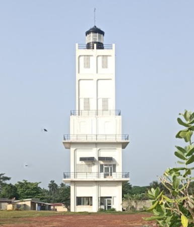
Petit Bassam Light, Port Bouët, February 2024
Google Maps photo by Ana Costa

Lagunes Region Lighthouses
* Grand-Bassam
1915. Inactive since 1951 but still listed by the Admiralty and NGA. Approx. 24 m (79 ft) masonry tower with lantern and gallery, centered on a 1-story masonry keeper's house. Lighthouse painted white, at least originally; most of the paint is missing in Cedrick Nanan's 2023 photo seen at right. Alex Chou has a 2019 photo, C. Castor has a 2019 photo, Huelse has a historic postcard view, and Google has a satellite view. The history of this substantial but clearly endangered lighthouse is obscure. The light was deactivated in 1951 when the present Petit-Bassam light was placed in service. In 2012 the lighthouse was designated a UNESCO world heritage site. Grand-Bassam, a town about 40 km (25 mi) east of Port Bouët at the eastern end of the Lagune d'Ébrié, was briefly the French colonial capital (1893-96). The lighthouse marked a lagoon entrance which has since silted up, so there is no modern harbor. Located in Ancien Bassam, the original French settlement, on the barrier island separating the ocean from the Lagune Ouladine at Grand Bassam. Site open, tower closed. ARLHS ICO-013; Admiralty D3137.5; NGA 24843.
* Port Bouët (Petit-Bassam) (3?)
1951 (station established around 1906). Active; focal plane 34 m (112 ft); three white flashes every 14 s. 30 m (98 ft) five-stage square tower with galleries atop each stage and a small lantern. Lighthouse painted white, lantern black. Ana Costa's 2024 photo is above, Kôrô M'biao has a 2017 photo, Anastase Gnamou has a 2018 photo, Venance Assiene has a second 2018 photo, Nicolas McDuff Champoux has a 2022 photo, Lightphotos.net has a view from the sea, and Google has a satellite view. Klaus Huelse has a postcard view of the original lighthouse, a two-stage octagonal tower on a square base, and a second postcard view showing the tower in use during the 1930s. Port Bouët is the original port in the Abidjan area. Located about 5 km (3 mi) east of the Vridi Canal in Port Bouët. Site open, tower closed. ARLHS ICO-002; Admiralty D3127; NGA 24840.
Canal de Vridi (Abidjan) Jetée Nord (2)
2020 (?) (station established early 1950s). Active; focal plane about 16 m (52 ft); green light, pattern unknown. Approx. 12 m (39 ft) round green barbell-shaped tower. Mehmet Ali Solak has a 2020 photo, Derka Coul has a 2022 closeup, Marc Seka has a November 2020 Google Maps video, the light is in the lower right corner in Abdoulaye Sow's 2023 aerial view, and Google has a satellite view. The original lighthouse was a 12 m (39 ft) gray masonry tower with a small lantern and gallery, attached to a 1-story equipment shelter. Trabas has a photo of that light, David De Backere has a 2012 photo, Luc Roussouliere has a 2015 photo of both jetty lights, and Lightphotos.net has a 2010 photo of both jetty lights. The Vridi Canal cuts through the barrier beach, providing large ships access to the Lagune Ébrié and the port of Abidjan. The canal was completed in 1951 and helped make Abidjan one of the largest cities of West Africa. Located at the end of the short north jetty. ARLHS ICO-009; Admiralty D3129; ex-NGA 24812.

Grand-Bassam Light, Grand-Bassam, February 2023
Google Maps photo by Cedrick Nanan
Canal de Vridi (Abidjan) Jetée Sud (2)
2020 (?) (station established early 1950s). Active; focal plane about 16 m (52 ft); red light, pattern unknown. Approx. 12 m (39 ft) round red barbell-shaped tower. The light is in the lower left corner in Abdoulaye Sow's 2023 aerial view, Google has a satellite view. The original lighthouse was a 13 m (43 ft) gray masonry tower with a small lantern and gallery. Luc Roussouliere has a 2015 photo of both jetty lights, and Lightphotos.net has a 2010 photo of both jetty lights. Located at the end of the south jetty, which also serves as a breakwater protecting the entrance. ARLHS ICO-010; Admiralty D3128; ex-NGA 24804.
 
Abidjan Entrance Range Front
Date unknown. Active; focal plane 14 m (46 ft); red light occulting once every 4 s, synchronized with the rear light. 12 m (39 ft) square red skeletal tower with a white rectangular daymark, framed by two white triangular beacons having white rectangular daymarks. Lightphotos.net has a photo, Frank Taypen has a view from the Canal, and Google has a satellite view. Located on the west side of the Canal de Vridi about 800 m (1/2 mi) inside the entrance. Site status unknown. Admiralty D3130; NGA 24816.
Abidjan Entrance Range Rear
Date unknown. Active; focal plane 18 m (59 ft); red light occulting once every 4 s, synchronized with the front light. 16 m (52 ft) white tower with a rectangular daymark white with a red V, framed by two white triangular beacons having rectangular daymarks with red and white stripes. Lightphotos.net has a photo and Google has a satellite view. Located 430 m (1/4 mi) northwest of the front light. Site status unknown. Admiralty D3130.1; NGA 24820.
Abidjan Second Range Front
Date unknown. Active; focal plane 17 m (56 ft); quick-flashing white light. Approx. 14 m (46 ft) square skeletal tower painted with black and white horizontal bands. Lightphotos.net has a photo and Google has an indistinct satellite view. Located on the west bank of the Canal de Vridi at about the halfway point of the waterway. Admiralty D3131; NGA 24824.
Abidjan Second Range Rear
Date unknown. Active; focal plane 30 m (98 ft); white light occulting twice every 6 s. Approx. 26 m (85 ft) square skeletal tower painted with black and white horizontal bands and topped by a large square structure. Lightphotos.net has a photo and Bing has an indistinct satellite view. Located in an urban neighborhood on the west side of the northern entrance to the Canal de Vridi. Admiralty D3131.1; NGA 24828.
Treitchville
Date unknown. Active; focal plane 41 m (135 ft); three green flashes in a 2+1 pattern every 12 s. Approx. 25 m (82 ft) round unpainted concrete water tower. Lightphotos.net has a photo and Google has a satellite view. Located in Treitchville, the port district of Abidjan. Site status unknown. Admiralty D3135; NGA 24836.
Treitchville Quay
Date unknown. Active (?); focal plane 23 m (75 ft); quick-flashing green light. 19 m (62 ft) square cylindrical skeletal tower. Lightphotos.net has a photo but the tower is inconspicuous in Google's satellite view. The light has been dropped from the Admiralty list. Located on the quay in downtown Abidjan. Site and tower closed. ex-Admiralty D3134; NGA 24832.
Jacqueville (Adjué)
Date unknown. Active (?); focal plane not listed; white flash every 4 s. 15 m (49 ft) white tower. No photo available but Google has a satellite view. The navigational function of this light is not clear. Located at Adjué, about 65 km (40 mi) west of Abidjan. Site status unknown. ARLHS ICO-011; Admiralty D3126; NGA 24798.
#Grand Lahou (3)
Date unknown (station established 1901?). Probably destroyed, but listed by NGA with focal plane 13 m (43 ft); three white flashes in a 2+1 pattern every 15 s. This was a 17 m (56 ft) cylindrical tower with lantern and gallery. Previously painted white with a black lantern, the lighthouse is now listed as "white and red." However, it seems clear that this lighthouses does not survive. No current photo is available and the lighthouse has not been found in Google's satellite view. In addition, ruins of a lighthouse were visible in the surf, according to a 2007 BBC article that described how the town was being lost to rising sea levels. Satellite imagery indicates that the lagoon entrance has migrated westward over the location of the lighthouse. The original Grand Lahou was a European outpost built on a barrier island; the French developed it as a base beginning in 1890. The modern town has relocated to the mainland across the lagoon, leaving the old town in ruins. The history of the lighthouse is not clear; it appears that the original light, a tall masonry tower similar to the 1915 Grand Bassam light (see above), was replaced in the late 1930s by the lighthouse shown in the postcard view posted by Huelse. The most recent lighthouse was apparently built sometime after World War II. Formerly located near the entrance to the lagoon, about 100 km (60 mi) west of Abidjan. Site status unknown. ARLHS ICO-001; ex-Admiralty D3125; NGA 24796.

Bas-Sassandra Region Lighthouses
Sassandra
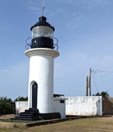
1908. Active; focal plane 60 m (197 ft); white light occulting once every 4 s. 7 m (23 ft) round masonry tower with lantern and gallery. Lighthouse painted white, lantern black. Ana Costa's 2023 photo is at right, Craig Hitchcock contributed a 2014 closeup photo, another photo is available, and Google has a satellite view. Sassandra is a historic fishing port now known more for its beaches. Located on a promontory on the south side of Sassandra, about 1.6 km (1 mi) southwest of the harbor entrance. Site status unknown. ARLHS ICO-004; Admiralty D3122; NGA 24788.

Sassandra Light, Sassandra, April 2023
Google Maps photo by Ana Costa
San Pédro
Date unknown. Active; focal plane 106 m (348 ft); white flash every 4 s. Square cylindrical skeletal tower, height unknown but probably at least 30 m (98 ft), painted with red and white horizontal bands. Steffen Neumann has contributed a photo, Marck Kanga has a distant 2023 view, and Google has a satellite view. San Pédro is the second largest port of Ivory Coast, with a population of about 175,000. Located on a steep headland about 2 km (1.25 mi) northeast of the harbor entrance. Site status unknown. ARLHS ICO-014; Admiralty D3120; NGA 24768.
San Pédro Jetée Ouest
Date unknown. Active; focal plane 15 m (49 ft); two white flashes every 3 s. 7 m (23 ft) mast atop a 1-story equipment building. Mast painted with red and white bands, building painted white. Lightphotos.net has a photo and Google has a satellite view. Located on the breakwater jetty at the entrance to San Pedro. Site status unknown. Admiralty D3120.2; NGA 24784.
Pointe Tafou
1908. Active; focal plane 25 m (82 ft); three white flashes every 15 s. 14 m (46 ft) round cylindrical tower with lantern and gallery. Lighthouse painted white with a narrow black horizontal band and a black lantern. Israel Ange Elyon Doga's photo is at right, Erdoğan Gök has a 2015 photo, Dahmani Candide has a view from the sea, and Google has a satellite view. Located on a promontory near Tabou in southwestern Ivory Coast. Site status unknown. ARLHS ICO-006; Admiralty D3118; NGA 24764.

Information available on lost lighthouses:

  • Assinie (1908-?), near the Ghanaian border. A postcard view is available. The fate of this lighthouse is unknown; like the Grand-Lahou lighthouse it may have been lost to beach erosion. ARLHS ICO-012.

Notable faux lighthouses:


Pointe Tafou Light, Tabou, November 2018
Google Maps photo by Israel Ange Elyon Doga

Adjoining pages: East: Ghana | West: Liberia

Return to the Lighthouse Directory index | Ratings key

Posted September 13, 2005. Checked and revised April 13, 2024. Lighthouses: 16. Site copyright 2024 Russ Rowlett and the University of North Carolina at Chapel Hill.