Lighthouses of Cameroon

The Republic of Cameroon (République du Cameroun in French) is located at the "hinge" of Africa's west coast, southeast of Nigeria. During the colonial period the country was originally a German colony called Kamerun. French and British troops captured it quickly at the start of World War I in 1914, and after the war the colony was divided between the two allies. The northern coast, including Capes Debundscha and Nachtigal, fell in the British zone called Southern Cameroons and the southern coast, including Kribi, in the French. In 1960 the people of the coastal region of British Cameroon voted to join with French Cameroun to form the present nation. Since 2017, however, there has been a separatist movement in the English-speaking region of the country; the separatists call the region Ambazonia.

Cameroon is divided into 10 semi-autonomous regions.

Both French and English are official languages in Cameroon. The French word for a lighthouse is phare, although a smaller light or harbor light is called a feu (literally "fire," but here meaning "light") or a balise (beacon). In French île is an island, cap is a cape, pointe is a promontory or point of land, roche is a rock, récife is a reef, baie is a bay, estuaire is an estuary or inlet, détroit is a strait, rivière is a river, and havre is a harbor.

Navigational aids in Cameroon are maintained by the port authorities of Douala, the country's traditional port, and Kribi, the terminus for an oil pipeline from Chad.

ARLHS numbers are from the ARLHS World List of Lights. Admiralty numbers are from volume D of the Admiralty List of Lights & Fog Signals. U.S. NGA List numbers are from Publication 113.

General Sources
Lighthouses in Cameroon
Photos by various photographers available from Wikimedia.
World of Lighthouses - Cameroon
Photos by various photographers available from Lightphotos.net.
Online List of Lights - Cameroon
Photos by various photographers posted by Alexander Trabas.
Afrikanische Leuchttürme auf historischen Postkarten
Historic postcard views posted by Klaus Huelse.
Navionics Charts
Navigation chart information for Cameroon.


Kribi Range Front Light, Kribi, March 2018
Google Maps photo by Yury Kravchuk

South Region Lighthouses
* Kribi Range Front (Margaret Point)
1906. Active; focal plane 18 m (59 ft); three white flashes every 12 s. 15 m (49 ft) cylindrical masonry tower with lantern and gallery. Tower painted white, lantern and gallery red. Yury Kravchuk has the 2018 closeup seen at the top of this page, Heather Talbot has a closeup photo, Naëlle le Moal has a 2012 closeup, Lightphotos.net has a photo, Wikimedia has a photo, Huelse has a historic postcard view as well as a more recent postcard view, and Google has a street view and a satellite view. The small keeper's cottage seen in the historic view has disappeared. Kribi is a beach resort (popular with surfers) at the mouth of the Kienké River in southern Cameroon. The lighthouse is easily accessible from the beach. Located on the south side of the entrance to the river. Site open, tower closed. ARLHS CAM-003; Admiralty D4134; NGA 25236.
* Kribi Range Rear
1906. Active; focal plane 30 m (98 ft); continuous green light visible only on the range line. Light mounted on the square steeple of the village church. Gervais Simon Belinga Atangana has a 2021 photo of the church, a 2017 photo is available, and Google has a satellite view. Located on the south side of the Kienké River in Kribi. Site open, church presumably open. ARLHS CAM-007; Admiralty D4134.1; NGA 25240.

Southwest Region Lighthouses
Cap Nachtigal (1)
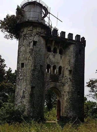
1904. Abandoned. A massive stone structure: two cylindrical towers joined by an arch to form a monumental gate, with a lantern atop one of the towers. Huelse has a historic postcard view and Google has a satellite view. This remarkable monument to German colonial energy was built in 1901 and the lantern was added three years later. It may have been in service for only a short time, since a 1916 coast pilot and a 1919 light list describe a framework tower on the cape. However, Torsten Steinberg, who visited the tower in September 2004, reported it had been out of service for about 40 years. It may be the light was erroneously listed as a framework tower, or it may be that the 1904 lantern was reactivated for some length of time after 1919. Steinberg also reported that the tower cannot be reached by land. In 2020 Dibussi Tande posted to Twitter the photo at right showing the historic tower in a state of decay and clearly not in service. The cape was named for Gustav Nachtigal, who founded the German colony of Kamerun in 1884. Located on the point of the cape, about 10 km (6 mi) south of Limbé. Accessible only by boat. Site open; tower status unknown. ARLHS CAM-006.
Cap Nachtigal (3?)
Date unknown. Active (?); focal plane 44 m (144 ft); white light, 1 s off, 1 s on. 13 m (43 ft) masonry tower. No photo available. The light was reportedly "repaired" in 2008, so it may be active. Accessible only by boat. Site open; tower status unknown. ARLHS CAM-002; Admiralty D4000; NGA 25100.

Cap Nachtigal Light, Limbé, February 2020
Twitter photo by Dibussi Tande
Cap Debundja (Debundscha) (1)
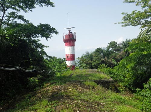
1904. Apparently reactivated in 2008 after being inactive since sometime around 1970; focal plane 41 m (134 ft); white flash every 5 s; a red flash is shown over a sector to the northwest. Approx. 13 m (43 ft) round cylindrical concrete tower with gallery; the lantern has been replaced by a radar antenna. Lighthouse painted with red and white horizontal bands. Ulrich Poggensee's photo is at right but Bing has only an indistinct satellite view of this station. Construction of the lighthouse began in 1902. The lighthouse has been restored recently; it was abandoned and in poor condition in Roland Boula's 2009 photo. Cap Debundscha is the toe of Mount Cameroon, a 4095 m (13400 ft) active volcano that is the dominant feature of the northern coast of Cameroon. The nearby town of Debundja is the wettest place in Africa, as winds blowing up the mountain slope bring heavy rains totaling over 10 m (400 in) per year. Located on the cape, about 25 km (15 mi) west of Limbé (formerly Victoria). Probably accessible only by boat. Site and tower open if you can get to it. ARLHS CAM-005; Admiralty D3990; NGA 25084.
Cap Debundscha (Debundja) (2) (?)
Around 1970 (station established 1904). Inactive at least since 2008. 26 m (85 ft) square skeletal tower with lantern and gallery. Lighthouse painted white. No photo available. It is not clear whether this tower survives. Located on the cape, about 25 km (15 mi) west of Limbé (formerly Victoria). Site status unknown. ARLHS CAM-001.

Information available on lost lighthouses:

  • Bibundi (1911-?), north of Cap Debundscha. No additional information is available. ARLHS CAM-004.

1904 Cap Debundscha Light, Debundscha, February 2013
contributed photo copyright Ulrich Poggensee; used by permission

Notable faux lighthouses:

Adjoining pages: South: Equatorial Guinea | West: Nigeria

Return to the Lighthouse Directory index | Ratings key

Posted September 23, 2005. Checked and revised March 30, 2024. Lighthouses: 6. Site copyright 2024 Russ Rowlett and the University of North Carolina at Chapel Hill.