Lighthouses of the Republic of the Congo

There are two central African nations named for the Congo River: the Republic of the Congo and the Democratic Republic of the Congo. Both nations have been independent since 1960.

The Republic of the Congo, sometimes called Congo (Brazzaville) or the Congo Republic, is the former French Congo. Located entirely north of the Congo River, it has only a short coastline, about 170 km (105 mi) in length. However, this coast includes the major port of Pointe-Noire. To avoid the falls on the lower Congo, goods to and from all of central Africa are shipped by rail between Pointe-Noire and Brazzaville, which is on the river above the falls.

The Republic of the Congo is divided into 12 departments (départements).

French is an official language in The Republic, along with three indigenous languages. The French word for a lighthouse is phare, although a smaller light or harbor light is called a feu (literally "fire," but here meaning "light") or a balise (beacon). In French île is an island, cap is a cape, pointe is a promontory or point of land, roche is a rock, récife is a reef, baie is a bay, estuaire is an estuary or inlet, détroit is a strait, rivière is a river, and havre is a harbor.

Aids to navigation in the Republic of the Congo are maintained by the Port of Pointe Noire, operated by APM Terminals.

ARLHS numbers are from the ARLHS World List of Lights. Admiralty numbers are from volume D of the Admiralty List of Lights & Fog Signals. U.S. NGA List numbers are from Publication 113.

General Sources
World of Lighthouses - Congo Brazzaville
Photos by various photographers available from Lightphotos.net.
Online List of Lights - Congo
Photos by various photographers posted by Alexander Trabas.
Afrikanische Leuchttürme auf historischen Postkarten
Postcards from the collection of Klaus Huelse.
Lighthouses in Africa
Postcards from the collection of Michel Forand.
Navionics Charts
Navigation chart information for the Republic of the Congo.

Pointe Noire Light
Pointe Noire Light, Pointe Noire, May 2010
photo copyright Fabrice Moustic; permission requested
Pointe-Noire Department Lighthouses
* Djeno
Date unknown (modern). Active; focal plane 29 m (95 ft); white or red light, depending on direction, 3 s on, 1 s off. This light is almost certainly mounted on a 38 m (125 ft) triangular skeletal communications tower. Many photos of the tower are available and Google has a satellite view. Located at the Djeno oil terminal about 25 km (15 mi) southeast of Pointe Noire. Site open, tower closed. ARLHS CON-001; Admiralty D4319; NGA 25484.
Pointe Noire Passe Ouest (Inner Breakwater) (2)
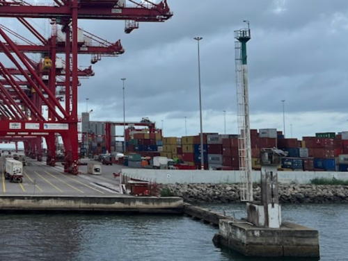
Date unknown. Active; focal plane about 23 m (75 ft); continuous green light. Approx. 20 m (60 ft) robust steel mast, painted white with a green band at the top. James Delaney has a 2023 photo and Vesseltracker.com has a photo by Jerzy Nowak but Google has only a fuzzy satellite view. NGA lists a light with focal plane 10 m (33 ft); it may have been mounted on the building seen at the pierhead. Located on a short breakwater at the container port on the west side of the harbor entrance. Site and tower closed. Admiralty D4314; NGA 25476.
Pointe Noire Passe Est (Detached Breakwater)
Date unknown. Active; focal plane 23 m (75 ft); continuous red light. 25 m (82 ft) white tower. Probably a similar mast, but no photo available and Google has only a fuzzy satellite view. Located on a long breakwater sheltering the container port on the west side of the harbor entrance. Accessible only by boat. Site and tower closed. Admiralty D4315; NGA 25460.
Pointe Noire
1927. Active; focal plane 27 m (89 ft); white flash every 5 s. 20 m (66 ft) octagonal concrete tower with lantern and gallery. The lighthouse has an unusual design, as seen in Fabrice Moustic's photo above. Tower painted white, with two black horizontal bands; lantern painted black. 1-story keeper's house. Franz-Luitpold Kessler has a 2005 closeup photo, Huelse has a historic postcard view, and Google has a dark satellite view and a very distant street view. Lightphotos.net has a 2013 photo and a historic photo of the lighthouse under construction in 1925-26. The lighthouse was repainted in early 2010. Located at the southern end of the Baie de Pointe Noire, on the west side of the city, near the base of the peninsula sheltering the harbor. Site status unknown (the area may be restricted; inquire locally). ARLHS CON-002; Admiralty D4311; NGA 25452.

Passe Ouest Light, Pointe Noire, April 2023
Google Maps photo by James Delaney
* Pointe Noire Cathédrale (Feu Postérieur)
Date unknown (the building was completed in 1953). Active; focal plane 40 m (131 ft); two continuous red lights, displayed side by side. Lights mounted on the steeple of the Cathédrale Notre-Dame de l'Assomption. Kim Do Young has a photo of the cathedral, Wikimedia has Loris Romito's photo, and Google has a satellite view. Forand has a postcard view in which it appears that the lights are on the left side of the open portion at the top of the tower. This was the rear light of the harbor entrance range; the front light was the Passe Est Light (previous entry). The range was discontinued sometime around 2010. Located at the southern end of the Baie de Pointe Noire, 1.4 km (0.9 mi) southeast of the lighthouse. Site open, tower closed. Admiralty D4315.1; NGA 25464.

Information available on lost lighthouses:

Notable faux lighthouses:

Adjoining pages: North: Gabon | South: Angola (Cabinda)

Return to the Lighthouse Directory index | Ratings key

Posted September 16, 2005. Checked and revised March 14, 2024. Lighthouses: 5. Site copyright 2024 Russ Rowlett and the University of North Carolina at Chapel Hill.