Lighthouses of Spain: Basque Country (Euskadi)

The Kingdom of Spain occupies nearly 85% of the Iberian Peninsula in southeastern Europe with coastlines facing south and southeast on the Mediterranean Sea and southwest and northwest on the Atlantic Ocean. Spain also includes the Balearic Islands in the Mediterranean, the Canary Islands in the Atlantic, and the cities of Ceuta and Melilla on the north coast of Morocco.

This page lists lighthouses of Euskadi, Spain's Basque Country (Euskadi in Basque, País Vasco in Spanish) including the provinces of Bizkaia (Vizcaya) and Gipuzkoa (Guipúzcoa). This area is at the eastern end of Spain's northern coast, adjoining the French border. It is a beautiful coastline where mountains drop steeply into the sea and occasional water gaps create small sheltered harbors. Bilbao is the largest port in the region.

Spain is divided into 17 regions called autonomous communities (comunidades autónomas); the Basque Country is one of these communities. The Basque provinces are divided into districts called eskualdeak in Basque or comarcas in Spanish.

Web sites based in this area are often in the Basque language Euskara rather than in Spanish (or in addition to Spanish). The Basque word for a lighthouse is itsasargia; uhartea is an island and portua is a port or harbor. The Spanish word is faro, but its use is generally restricted to the larger coastal light stations. Smaller lighthouses are called balizas (beacons). In Spanish isla is an island, cabo is a cape, punta is a promontory or point of land, péñon is a rock, arrecife is a reef, bahía is a bay, ría is an estuary or inlet, estrecho is a strait, río is a river, and puerto is a port or harbor.

The navigational lights in Spain are the responsibility of the national port authority, Puertos del Estado, but many of them are operated and maintained by regional port authorities, located at Bilbao in Vizcaya and at Pasajes in Guipúzcoa. The Comisión de Faros, founded in 1842 to build and maintain Spanish lighthouses, is now an advisory panel.

ARLHS numbers are from the ARLHS World List of Lights. ES numbers are from the Spanish national list of lights, Libro de Faros. Admiralty numbers are from volume D of the Admiralty List of Lights & Fog Signals. U.S. NGA List numbers are from Publication 113.
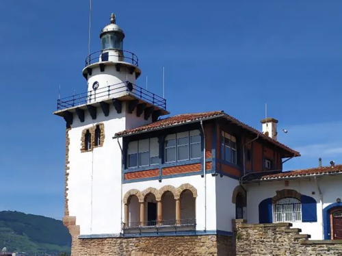

Arriluze Light, Getxo, June 2010
Wikimedia Creative Commons photo by Zarateman

General Sources
Libro de Faros y Señales de Niebla
Online edition of the official Spanish light list.
Online List of Lights - Spain Atlantic Coast
Photos by various photographers posted by Alexander Trabas. Many of the photos from the Basque Country are by Arno Siering.
Faros de España
Links to articles in the Spanish edition of Wikipedia.
Lighthouses in the Basque Country
Photos by various photographers available from Wikimedia.
World of Lighthouses - Spain
Photos by various photographers available from Lightphotos.net.
Lighthouses in Spain
Excellent aerial photos posted by Marinas.com.
Faros del Mundo
Photos and accounts by Carlos Olmo Bosco.
Phares d'Europe
This French-language site by Alain Guyomard and Robert Carceller has pages for many of the lighthouses of northern Spain.
Leuchtturme.net - País Vasco
Photos posted by Malte Werning.
Leuchttürme Spaniens auf historischen Postkarten
Historic postcard images posted by Klaus Huelse.
GPSNauticalCharts
Navigational chart for northern Spain.
Navionics Charts
Navigational chart for northern Spain.

Faro de Santa Catalina
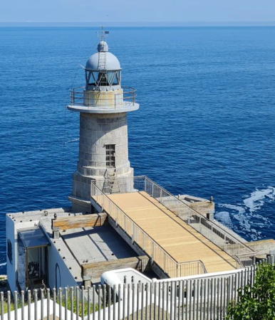
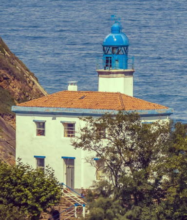
Santa Catalina Light, Lekeitio, June 2010
Flickr Creative Commons photo by alexmgpg

Lighthouses of Bizcaia (Vizcaya)

Lighthouses in Bizkaia are operated by the Bilbao port authority, Bilboko Portuko Agintarintza (Autoridad Portuaria de Bilbao). The town of Getxo includes the port facilities of Bilbao.

Bilboaldea (Gran Bilbao) District Lighthouses
* Santurtzi (Santurce) (2)
Date unknown. Active; focal plane 20 m (66 ft); three green flashes every 10 s. 14 m (46 ft) round cylindrical tower with lantern, painted green; lantern dome is brown metallic. Trabas has Siering's closeup photo and Google has a satellite view. The light was originally on the roof of the harbor administration building. The Santurtzi piers are on the west side of Getxo harbor, northwest (outside) of the Contradique de Algorta. Located at the end of the pier, in front of the administration building. Located at the easternmost corner of the piers. Site open, tower closed. ARLHS SPA-119; ES-00704; Admiralty D1527; NGA 1920.
* Espigón de Portugalete (Muelle de Hierro) (2?)
Date unknown (station established 1892). Active; focal plane 14 m (46 ft); three green flashes, in a 2+1 pattern, every 10 s. 8 m (26 ft) octagonal concrete tower with gallery, painted gray with one yellow horizontal band. The tower was formerly green with a red horizontal band (the colors of the Euskadi flag). Andreas Köhler has a 2023 photo showing the new color pattern. Trabas has another photo by Köhler, Mauricio Sanchez has a 2018 closeup, and Google has a street view and a satellite view. Located at the end of long pier sheltering the inner small boat harbor of Getxo. Accessible by walking the pier. Site open, tower closed. ES-00780; Admiralty D1529; NGA 1940.
* Arriluze (Getxo Contradique de Algorta Arranque)
Date unknown. Inactive. 20 m (66 ft) two-stage round cylindrical tower with lantern and gallery (upper stage round, lower stage square stone), attached to a 2-story keeper's house. Tower painted white with unpainted stone trim; lantern roof is gray metallic. A photo is at the top of this page, Julia Castillo has a 2021 photo, Guyomard and Carceller have a photo (at right on their page), Wikimedia has several photos, and Google has a street view and a satellite view. Located on the Muelle de Arriluze at the root of the Contradique de Algorta in Getxo. Site open, tower closed. . ARLHS SPA-315; ex-Admiralty D1526.
Getxo Contradique de Algorta (East Breakwater)
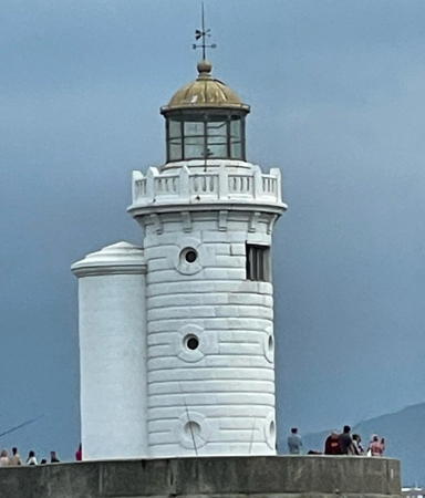
1904. Active; focal plane 18 m (59 ft); red flash every 5 s. 15 m (49 ft) round cylindrical granite tower with lantern and gallery. Entire lighthouse painted white. Mikel Agirregabiria's photo is at right, Trabas has Siering's closeup photo, Alfredo Ruiz de Gordejuela has a 2018 photo, Guyomard and Carceller have a photo (at left on their page), Mariann Rasmussen has a 2021 photo, Wikimedia has a sunrise photo, David Alvarez has a sunset street view, Huelse has a historic postcard view, and Google has a satellite view. The Contradique de Algorta, 1148 m (0.71 mi) long, was built between 1893 and 1901 to provide a sheltered harbor at Getxo, the port of the city of Bilbao. Located at the end of the breakwater, guarding the narrow entrance to the inner harbor. Accessible by walking the breakwater. Site open, tower closed. ARLHS SPA-094; ES-00720; Admiralty D1525; NGA 1912.
* Fuerte de la Galea (3)
1895 (station established 1782). Inactive since about 1905. Approx. 10 m (33 ft) unpainted round cylindrical stone tower with gallery. Lantern removed. Tomas Pardo has a 2016 photo, Ivan Costinha has a 2008 photo, Evgeniy Kiselev has a street view, and Google has a satellite view. The mid-18th century Fuerte de la Galea is located at the water's edge about 600 m (3/8 mi) southeast of Punta Galea. The 1852 lighthouse was a 12.5 m (41 ft) tower on a wall of the fort. Site open, tower closed.

Contradique de Algorta Light, Getxo, July 2008
Flickr Creative Commons photo by Mikel Agirregabiria

* Punta Galea (3)
1950 (station established 1852). Active; focal plane 84 m (276 ft); three white flashes every 8 s. 8 m (26 ft) round cylindrical rubblestone tower with lantern and gallery, attached to the front of a 1-story keeper's house. Tower unpainted; the lantern is painted with a red band around the base but is otherwise clear glass including the dome; gallery rail painted white. Iñaki Vigiola has a lovely photo, Trabas has Siering's photo, Sergio Gaztambide has a photo, Maite Marcos has a 2018 photo, and Google has a street view and a satellite view. The second (1905) light replaced the Fuerte de la Galea lighthouse (previous entry). It was demolished in 1950 when it became threatened by erosion of the cliff. In 2016 the port authority announced it would lease the lighthouse as a restaurant. Located on a bold promentory off the Camino de la Galea in Getxo, marking the eastern entrance to the Bahía de Getxo, the harbor of Bilbao. Site open, tower closed. . ARLHS SPA-232; ES-00615; Admiralty D1524; NGA 1900.

Mungialdea District (Uribe) Lighthouse
* Górliz (Cabo Villano)
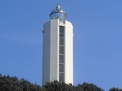
1991. Active; focal plane 165 m (541 ft); three white flashes, in a 1+2 pattern, every 12 s. 21 m (69 ft) 10-sided cylindrical concrete tower with lantern but no gallery; 3rd order Fresnel lens. Tower is white concrete; lantern painted black. A photo is at right, Trabas has Siering's excellent photo, a 2018 closeup is available, Andrés Varney has a street view, and Google has a satellite view. This modern lighthouse, the first in its location, marks a prominent cape on the northeastern approach to Bilbao. It was built as part of the Plan de Señales Marítimas 1985-89, a national plan to upgrade coastal aids to navigation. Note: not to be confused with another Cabo Villano lighthouse in Galicia. Located atop a steep slope on Monte Ermua, about 5 km (3 mi) north of Górliz. Accessible by a winding mountain road, the site offers magnificent views of the sea. Site open, tower closed. . ARLHS SPA-286; ES-00610; Admiralty D1523; NGA 1898.

Górliz Light, Gorliz, March 2009
Flickr Creative Commons photo by ikerpe

Busturialdea District (Guernica) Lighthouses
* Cabo Machichaco (Matxitxako) (1)
1852. Inactive since 1909. Approx. 13 m (43 ft) stone tower, unpainted. The lantern, probably removed long ago, has been replaced in recent years by a radar antenna. Hans van Reenen has a closeup photo, Wikimedia has a photo, Jorge Mazoteras has a 2022 photo, and Google has a street view and a satellite view. Located below the current lighthouse; Huelse has a historic postcard view that shows both lighthouses and their relationship. Located on the cape, at the end of the BI-4203 highway, about 10 km (6 mi) northwest of Bermeo. Accessible by road, parking available. Site open, tower closed. ARLHS SPA-317.
** Cabo Machichaco (Matxitxako) (2)
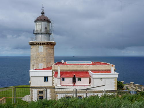
1909 (station established 1852). Active; focal plane 122 m (400 ft); white flash every 7 s. 20 m (66 ft) octagonal cylindrical stone tower with lantern and gallery, attached to the front of a 2-story keeper's house. Unpainted: the tower is gray-brown stone and the lantern is light gray metal. 1st order Fresnel lens in use. A 2021 photo is at right, Trabas has Siering's photo, José Sabate has a 2016 closeup, Marinas.com has aerial photos, and Google has a street view and a satellite view. The lighthouse marks the most prominent and dangerous cape of the Basque coastline and is said to be Spain's most powerful light, with a range of 48 km (24 mi). Located on heights above the older lighthouse. Visiting this lighthouse requires hiking from the older one. Site open; keepers will usually give guided tours if their time permits. . ARLHS SPA-032; ES-00580; Admiralty D1520; NGA 1892.
* Rompeolas de Bermeo (Bermeo Breakwater) (2)
Date unknown. Active; focal plane 18 m (56 ft); green flash every 4.5 s. Approx. 8 m (26 ft) round unpainted gray stone tower. Søren Pedersen has a 2021 photo, Fernando Catalina Landa has a 2010 photo, Trabas has Siering's photo, Tim Rademacher has a very distant street view, and Google has a satellite view. The Libra de Faros lists a smaller taller. Located at the end of the north (main) breakwater of Bermeo harbor. Accessible by walking the pier. Site open, tower closed. ES-00550; Admiralty D1513; NGA 1872.

Cabo Machichaco Light, Bermeo, August 2021
Wikimedia Creative Commons photo by Vanbasten 23
* Rosape (Punta Lamiaren)
Date unknown (station established 1868). Active; focal plane 38 m (125 ft); two flashes every 10 s, white or red depending on direction. Light mounted on one corner of a 1-story masonry keeper's house. House painted white with gold trim. Trabas has Eckhard Meyer's photo and Google has a satellite view and a street view from below the lighthouse. Located at the east end of Bermeo harbor, about 1.5 km (1 mi) east of the town center. Site open, tower closed. ARLHS SPA-115; ES-00540; Admiralty D1512; NGA 1868.

Lea-Artibai District Lighthouse
*** Cabo de Santa Catalina (Lekeitio)
1862. Active; focal plane 46 m (151 ft); four white flashes, in a 1+3 pattern, every 20 s. 13 m (43 ft) two-stage round masonry tower with lantern and gallery, attached to one end of a 1-story keeper's house. The lower 1/2 of the tower is octagonal cylindrical, and the upper half is conical. Tower is unpainted gray stone, lantern roof metallic, keeper's house painted white. A 2010 photo is at the top of this page, Trabas has Siering's photo, Xisco Fuster has a 2021 photo, Marinas.com has aerial photos, and Google has a satellite view. The light station was opened to the public after a €2.7 million renovation project was completed in March 2010. The keeper's houses now include a museum on the Basque maritime and lighthouse heritage. The lighthouse is perched on a vertical cliff at the end of the Avenida de Santa Catalina north of Lekeitio. Accessible by road; limited parking available. Site open, museum open daily, tower status unknown. Site manager: Lekeitio Centro de Patrimonio Maritimo. . ARLHS SPA-022; ES-00460; Admiralty D1502; NGA 1840.

Lighthouses of Gipuzkoa (Guipúzcoa)

Lighthouses in Gipuzcoa are operated by the Pasaia port authority, Pasaiako Portuko Agintaritza (Autoridad Portuaria de Pasajes).

Debabarrena District Lighthouses
* Mutriku (Motrico) (Range Rear)
Date unknown. Inactive since 2009. 15 m (49 ft) square cylindrical masonry tower of the church of San Miguel Arcangel. Google has a street view and a satellite view. The front light (still active, ES-00400, Admiralty D1496) is on a red mast at the end of the harbor breakwater. Located above the harbor of Mutriku (Motrico). Site open, tower closed. ARLHS SPA-320; ex-Admiralty D1496.1; ex-NGA 1828.

Urola Costa District Lighthouses
* Rompeolas de Zumaya (Zumaia Breakwater)
1927? Active; focal plane 20 m (66 ft); green flash every 5 s. 7 m (23 ft) round conical stone tower; no lantern. Trabas has Siering's closeup photo, Jésus Renes has a 2018 closeup, Andreas Köhler has a 2023 photo, and Google has a satellite view and a distant street view from across the harbor. Located at the end of a massive, curving breakwater (completed in 1927) that protects the west side of the entrance to the Río Urola estuary. Apparently accessible in good weather by walking the breakwater. Site open, tower closed. ARLHS SPA-322; ES-00375; Admiralty D1494; NGA 1812.
* Zumaia (Zumaya, Monte Atalaya) (2)
1882 (station established 1870). Active; focal plane 41 m (135 ft); white light, occulting four times in a 1+3 pattern every 12 s. 12 m (39 ft) octagonal cylindrical masonry tower with lantern and gallery, attached to the front of a 2-story keeper's house. Building painted white with blue trim; lantern and gallery painted blue. A photo is at right, Werning has a page for the lighthouse, Trabas has Siering's photo, Wikimedia has a 2010 photo by Jean Michel Etchecolonea, Mercedes González has a 2017 photo, and Google has a street view and a satellite view. The original light was on an 18 m (59 ft) tower at a different location. Located at the end of a peninsula on the west side of the entrance to the Río Urola estuary, north of the town of Zumaya. Site open, tower closed. . ARLHS SPA-003; ES-00370; Admiralty D1493; NGA 1808.
Getaria (Guetaria, Punta de San Antón)
1863. Active; focal plane 93 m (305 ft); four white flashes every 15 s. 14 m (46 ft) octagonal cylindrical masonry tower with lantern and double gallery, attached to one end of a 2-story keeper's house. Lantern, watch rooms, and both galleries painted white; lower portion of tower unpainted; keeper's house partially painted, displaying white vertical panels separated by unpainted gray masonry. Trabas has Siering's photo, Malte Werning has a good photo, Francisco Javier López García has a 2017 photo, Erminia Rondi has a 2022 photo, Marinas.com has spectacular aerial photos (misidentified as Monte Igueldo), Klaus Huelse has a historic postcard view, and Google has a street view and a satellite view. The modern lantern raised the height of the light from the original 90 m (295 ft). Located at the end of a rugged peninsula projecting into the ocean at Guetaria. Site and tower appear to be closed, but the lighthouse can be viewed from fairly close by. . ARLHS SPA-216; ES-00335; Admiralty D1489; NGA 1804.
Zumaya Light
Zumaya Light, Zumaya, April 2008
Wikimedia Creative Commons photo by Mikel

Donostialdea District: Donostia-San Sebastián Area Lighthouses
San Sebastián is the provincial capital; it has a metropolitan population of about 450,000. Its Basque name Donostia also means "San Sebastián."
*** Monte Igueldo (Igeldo Mendia) (1)
1778. Inactive since 1855. Approx. 23 m (75 ft) square cylindrical stone tower with a castellated top. Cyril Leau has a 2020 photo, Google has a street view and an excellent satellite view. This light had a focal plane of about 180 m (600 ft), too high to be useful in foggy conditions, so it was replaced by the lower lighthouse. In 1912, the Sociedad Monte Igueldo acquired the tower and rebuilt it in part, adding the elaborately castellated gallery at the top. Monte Igueldo is a mountain on the west side of the Bahía de la Concha on the northwest side of San Sebastián. The mountain is incorporated in a park that features natural features and historical attractions (such as the lighthouse) as well as amusement rides. Access is by a historic funicular railway. Located at the top of the mountain. Site and tower open. Site manager: Parque de Atracciones Monte Igueldo.
* Monte Igueldo (Igeldo Mendia) (2)
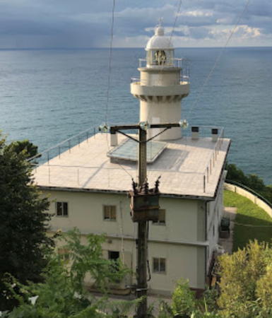
1855 (station established 1778). Active; focal plane 134 m (440 ft); three white flashes, in a 2+1 pattern, every 15 s. 13 m (43 ft) round cylindrical masonry tower with lantern and gallery, rising from the front of a 2-story stone keeper's house. 2nd order Fresnel lens in use. Building painted white with gray trim. Philip Maiwald's photo is at right, Trabas has Siering's closeup photo, Wikimedia has photos, Norbert Frischauf has a closeup photo, Marinas.com has aerial photos, Huelse has a historic postcard view, and Google has a street view and a satellite view. Accessible by road, but there's no parking at the lighthouse. Site open, tower closed. . ARLHS SPA-141; ES-00240; Admiralty D1483; NGA 1788.
* Isla de Santa Clara (Santa Klara Uhartea)
1864. Active; focal plane 53 m (174 ft); white flash every 5 s. 10 m (33 ft) round cylindrical stone tower with lantern and gallery, attached to a 2-story stone keeper's house. Building painted white with unpainted stone trim; lantern roof is red. Trabas has a photo, Marcel Terhoeve has a 2021 closeup, John Rooney has a 2022 closeup, Miren Lopez has a drone view, Marinas.com has aerial photos, and Google has a satellite view. The lighthouse is built on the site of an 18th century monastery. Located on a steep summit on an island in the mouth of the Bahía de la Concha at San Sebastián, the capital of Guipúzcoa. The island is accessible by passenger ferry during the summer. Site open, tower closed. ARLHS SPA-147; ES-00230; Admiralty D1482; NGA 1792.
Monte Igueldo Light
Monte Igueldo Light, San Sebastián, October 2009
Wikimedia Creative Commons photo by Phillip Maiwald

Donostialdea District: Pasaia (Pasajes) Area Lighthouses
Cabo La Plata (Platako)
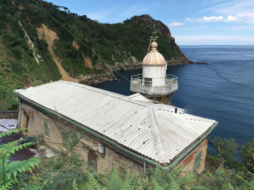
1855. Active; focal plane 153 m (502 ft); white flash every 4 s. 13 m (43 ft) round cylindrical stone tower with lantern and gallery mounted on the flat roof of a 3-story castle-like keeper's house. Building painted white with gray trim. Trabas has a closeup photo, Wikimedia has photos, Arseni Mourzenko has a 2016 photo, Esther Larrion has a 2022 drone view, Marinas.com has aerial photos, and Google has a satellite view. This light was originally listed at a focal plane of 148 m (486 ft), so the light tower was raised in height at some time. The building is set into the mountain so that from the sea only the light tower is visible. Perhaps needless to say, the site offers spectacular views of the Atlantic to the north. Located on the Monte Ulía, on the west side of the entrance to the Bahía de Pasajes, about 8 km (5 mi) north of Pasaia. Accessible by hiking the access road. There is a scenic overlook with a picnic area nearby. Site open, tower closed. ARLHS SPA-133; ES-00120; Admiralty D1456; NGA 1728.
Punta de Senokozulúa (Punta de Cruces)
1909. Active; focal plane 52 m (171 ft); white, red, or green light, depending on direction, 7.5 s on, 1.5 s off, 1.5 s on, 1.5 s off. 9 m (30 ft) octagonal stone tower with lantern and gallery, attached to the front of a 1-story stone keeper's house. Tower and keeper's house are unpainted ochre-colored stone; lantern and gallery painted white and the house has a white roof. A photo by Ceferino Fernandez is at right, Trabas has an excellent closeup photo, a 2022 photo is available, and Google has a satellite view. This directional light guides ships through the narrow entrance to the Bahía de Pasajes. Located on a bluff above the west side of the channel about 2.5 km (1.5 mi) north of Pasaia. Accessible by hiking from the road that leads to the Cabo de la Plata Light. Site open, tower closed. ARLHS SPA-127; ES-00140; Admiralty D1458; NGA 1736.
* Dique de Senokozulúa
Date unknown. Active; focal plane 14 m (46 ft); two green flashes every 7 s. 7 m (23 ft) round cylindrical solid concrete tower rising from a 1-story concrete block equipment room. Tower painted with horizontal green and white bands. Trabas has Siering's photo, Andreas Köhler has a 2023 photo, François Gabard has a closeup street view, and Google has a satellite view. Located at the end of a short pier extending into the Bahía de Pasajes at the foot of the cliff below the Punta de Senokozulúa lighthouse. Accessible by walking the breakwater. Site open, tower closed. ARLHS SPA-359; ES-00160; Admiralty D1460; NGA 1748.
* [Punta del Mirador]
Date unknown. Active; focal plane 13 m (43 ft); red flash every 5 s. 7 m (23 ft) slender stone tower supported by an arch that spans the walkway along the shore. This is not a lighthouse by any reasonable definition but it is an interesting light nonetheless. Trabas has Eckhard Meyer's closeup photo, another photo is available, Mathieu Rella has a street view, and Google has a satellite view. This light marks the point where the narrow channel from the sea to Pasaia opens out into the inner harbor. Located off the Torreatze Kalea in Pasaia. Site open, tower closed. ARLHS SPA-321; ES-00185; Admiralty D1468; NGA 1756.

Punta de Senokozulúa Light, Pasaia, May 2017
Google Maps street view by Ceferino Fernandez
* [Punta Arroka (Punta Teodoro Arroca)]
Date unknown. Active; focal plane 21 m (69 ft); three red flashes every 9 s. 9 m (30 ft) post light, painted with red and white horizontal bands, standing beside a small equipment shelter. Trabas has Helmut Seger's photo, Aitor Jorge Pascua has a street view, and Google has a satellite view. This very modest light is found on most lists of Spanish lighthouses. Located on the east side of the channel leading to the inner harbor of Pasaia, about 1.5 m (1 mi) north of Pasai Donibane. Site open, tower closed. ARLHS SPA-268; ES-00170; Admiralty D1472; NGA 1768.
Punta Arando Aundi (Pasaia Entrada, "Faro de San Juan")
Date unknown. Active; focal plane 12 m (39 ft); two red flashes every 7 s. 8 m (26 ft) round cylindrical tower mounted on a 1-story square stone pier. Tower painted with narrow red and white horizontal bands; equipment room painted white. Trabas has Helmut Seger's photo, another photo is available, Sergei Vichikov has a view from the sea, and Google has a satellite view. The light marks the entrance to the Bahía de Pasajes, a narrow water gap in a steep mountain ridge. Located at the end of a short jetty on the east side of the entrance, about 4 km (2.5 mi) north of Pasai Donibane. Heavy surf makes walking this exposed jetty dangerous. Site and tower closed but the light can be seen from the end of a hiking trail. ARLHS SPA-280; ES-00130; Admiralty D1457; NGA 1732.

Bidasoaldea (Bajo Bidasoa) District Lighthouse
*
Cabo Higuer (Cabo Higer, Fuenterrabía, Hondarribia) (2)
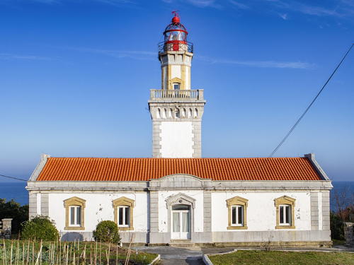
1881 (station established 1855). Active; focal plane 65 m (213 ft); two white flashes every 10 s. 21 m (69 ft) 2-stage round cylindrical stone tower with lantern and two galleries, the lower stage square and the upper stage octagonal, attached to a 1-story stone keeper's house. Building painted white with unpainted stone trim; the upper stage appears white with unpainted gray stone vertical stripes. The lantern is painted red, very unusual for a Spanish lighthouse. Batix Ezeiza's photo appears at right, Trabas has Siering's photo, Wikimedia has several excellent photos, Erlaitz Sanz Villar has a 2022 photo, Guyomard and Carceller have photos by Lionel Neyens, Werning has a page for the lighthouse, Huelse has a historic postcard view, and Google has a closeup street view and a satellite view. The original lighthouse was destroyed during the Carlist civil war in 1874. Cabo Higuer shelters the entrance to the Bahía de Txingudi (Baie de Chingoudy), an international harbor that serves both Hondarribia, Spain, and Hendaye, France. Located on the cape, about 3.5 km (2 mi) north of Hondarribia. Parking available. Site open, tower closed. . ARLHS SPA-029; ES-00050; Admiralty D1452; NGA 1712.

Cabo Higuer Light, Hondarribia, January 2021
Wikimedia Creative Commons photo by Batix Ezeiza

Information available on lost lighthouses:

Notable faux lighthouses:

Adjoining pages: East: Aquitaine | West: Asturias and Cantabria

Return to the Lighthouse Directory index | Ratings key

Posted November 18, 2005. Checked and revised August 5, 2023. Lighthouses: 24. Site copyright 2023 Russ Rowlett and the University of North Carolina at Chapel Hill.