Lighthouses of Spain: Southern Galicia (Pontevedra Province)

The Kingdom of Spain occupies nearly 85% of the Iberian Peninsula in southeastern Europe with coastlines facing south and southeast on the Mediterranean Sea and southwest and northwest on the Atlantic Ocean. Spain also includes the Balearic Islands in the Mediterranean, the Canary Islands in the Atlantic, and the cities of Ceuta and Melilla on the north coast of Morocco.

Since 1978 Spain has been divided into 17 regions called autonomous communities (comunidades autónomas). Galicia is an autonomous region in the northwestern corner of Spain. The Galician coastline is rugged and scenic but very dangerous to navigation; it is often called the "Coast of Death" (Costa da Morte in Galego). Many of the harbors are partly-sheltered bays called rías, actually the drowned lower valleys of rivers.

Galicia is divided into four provinces (provincias). This page includes lighthouses of the southwest coast of the region in Pontevedra Province. Galician provinces are subdivided into districts called comarcas.

Galicians speak Spanish or Galego, a distinctive language related to Portuguese. Galicia itself is called Galiza in Galego. The word for a lighthouse is faro in Spanish and farol in Galego, but its use is generally restricted to the larger coastal light stations. Smaller lighthouses are called balizas (beacons). In Galego illa is an island, cabo is a cape, punta is a promontory or point of land, rocha is a rock, arrecife is a reef, baía is a bay, ría is an estuary or inlet, estreito is a strait, río is a river, and porto is a port or harbor.

The navigational lights in Spain are the responsibility of the national port authority, Puertos del Estado, but many of them are operated and maintained by regional port authorities. The Comisión de Faros, founded in 1842 to build and maintain Spanish lighthouses, is now an advisory panel.

ARLHS numbers are from the ARLHS World List of Lights. ES numbers are from the Spanish national list of lights, Libro de Faros. Admiralty numbers are from volume D of the Admiralty List of Lights & Fog Signals. U.S. NGA List numbers are from Publication 113.

General Sources
Libro de Faros y Señales de Niebla
Online edition of the official Spanish light list.
Faros de España
Information on the major lighthouses posted by the national port authority, Puertos del Estado.
Faros de Galicia
A blog on Galician lighhouses posted by Marta Rivadulla.
Online List of Lights - Spain Atlantic Coast
Photos by various photographers posted by Alexander Trabas. Some of the photos for this area are by José Da Palma or Eckhard Meyer.
Phares d'Europe
Photos and notes in French by Alain Guyomard and Robert Carceller.
Spain Lighthouses
Aerial photos posted by Marinas.com.
Lighthouses in Galicia
Photos by various photographers available from Wikimedia.
World of Lighthouses - North and West Coasts of Spain
Photos by various photographers available from Lightphotos.net.
Balizamiento
Information posted by the Porto de Vigo.
Navigation Aid
Information posted by the Porto de Vilagarcía.
Plano de Faros y Balizas
Information posted by the Porto de Marín.
Leuchttürme Spaniens auf historischen Postkarten
Historic postcard images posted by Klaus Huelse.
GPSNauticalCharts
Navigational chart for Galicia.
Navionics Charts
Navigational chart for Galicia.
 

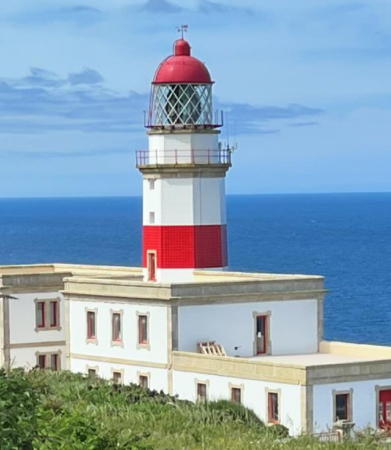
Cabo Silleiro Light
Cabo Silleiro Light, Bayona, October 2012
Flickr Creative Commons photo by Elentir


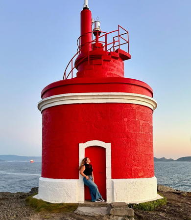
Punta Robaleira Light, Vigo, August 2017
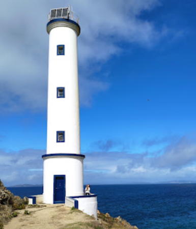
Google Maps photo by Mathieu Capronnier

Vigo District Lighthouses

Ría de Vigo South Side Lighthouses
* Cabo Silleiro (2)
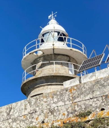
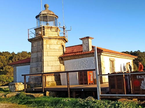
1924 (station established 1862). Active; focal plane 85 m (279 ft); three white flashes in a 2+1 pattern every 15 s. 30 m (98 ft) octagonal stone tower with lantern and gallery, attached to a large 2-story keeper's complex. Tower painted with red and white horizontal bands; lantern is red; keeper's house painted white with unpainted gray stone trim. A photo is at the top of this page, José Manuel Ortigueira Bobillo has a fine closeup, António Costa has a 2018 closeup, Trabas has a photo, and Google has a street view and a satellite view. Cabo Silleiro is a very prominent headland at the southern entrance to the Ría de Vigo, and the lighthouse here is important as a landfall light for Vigo and all the ports of Galicia. In 2020 the lighthouse was destaffed and transferred to local control; the plan is operate it as a boutique hotel. The lantern was removed temporarily for restoration but a March 2021 photo shows it back in place. Located just above the PO-552 coastal highway about 8 km (5 mi) southwest of Baiona. Site closed (the lighthouse can be viewed from outside the fence), tower closed. Operator: Autoridad Portuaria de Vigo. . ARLHS SPA-047; ES-05280; Admiralty D1916; NGA 3052.
* Cabo Silleiro (1)
1862. Inactive since 1924. Approx. 8 m (26 ft) stump of the square stone tower rising from the shell of the 1-story keeper's house. A closeup photo is available, Klaus Huelse has a historic postcard image, and Google has a satellite view and a distant street view. The old lighthouse housed the fog signal beginning in 1931 but it has been abandoned for many years. Located on the point of the cape, about 800 m (1/2 mi) north of the present lighthouse. Site open, tower closed.
Cabezo de San Xoan (Cabezo de San Juan, Puerto de Bayona Range Front)
Date unknown. Active; focal plane 9 m (30 ft); white flash every 6 s. 9 m (30 ft) round masonry beacon with gallery, painted white. Jose Carlos Gago has a photo, Trabas has a photo and Google has a satellite view. Located about 1.5 km (1 mi) offshore of Nigrán. Accessible only by boat. Site open, tower closed. Operator: Autoridad Portuaria de Vigo. ES-05250; Admiralty D1911; NGA 3040.
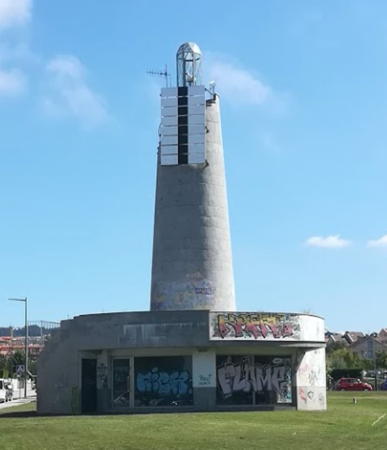
* Playa de Panxón (Panjón, Puerto de Bayona Range Rear) (2)
2007. Active; focal plane about 25 m (82 ft); white, red or green light, depending on direction, occulting once every 4 s. 15 m (49 ft) round concrete tower, centered on a 1-story building. The tower is unpainted gray concrete. A photo is at right, Trabas has Meyer's photo, José González has a photo, M.J.J. Rory has a 2021 photo, and Google has a street view and a good satellite view. Although the two Panjón lights still operate as a range, the directional light is effective at a greater distance. Located on the Avenida Bernardo Vázquez in Nigrán, a resort town north of Baiona. Site open, tower closed. Operator: Autoridad Portuaria de Vigo. ES-05251; Admiralty D1911.1; NGA 3044.
Islotes Las Serralleiras
Date unknown. Active; focal plane 11 m (36 ft); green flash every 4 s. 6 m (20 ft) round stone tower. Lighthouse painted white with a thin green band at the top. Trabas has Meyer's distant view and Google has a satellite view. Located on a reef on the south side of the entrance to the Ría de Vigo. Accessible only by boat. Site open, tower closed. Operator: Autoridad Portuaria de Vigo. ES-05230; Admiralty D1907; NGA 2938.
Cabo Estay Anterior (Range Front)
Date unknown. Active; focal plane 18 m (59 ft); white light, 1 s on, 1 s off. 6 m (20 ft) pentagonal tower with lantern and gallery, painted with red and white horizontal bands. Fog horn (Morse code "V" for Vigo: three shorts and one long, every 60 s). Trabas has an excellent closeup photo, Genaro Alonso Estevez has a 2017 photo, and Google has a street view and a satellite view. This is the initial entry range for the Ría de Vigo. Located on a headland on the south side of the lower Ría de Vigo, about 8 km (5 mi) southwest of Vigo and 2.5 km (1.5 mi) north of Saiáns. Site status unknown, although the lighthouse can be seen from nearby. Operator: Autoridad Portuaria de Vigo. ARLHS SPA-332; ES-05210; Admiralty D1890; NGA 2940.

Playa de Panxón Light, Nigrán, August 2020
ex-Google Maps photo by Ariberna OU
* Cabo Estay Posterior (Range Rear)
Date unknown. Active; focal plane 50 m (164 ft); white light, 1 s on, 1 s off. 7 m (23 ft) tile-covered pentagonal tower with lantern and gallery, painted with red and white horizontal bands. Trabas has an excellent photo, Gonzalo Pereira has a 2018 closeup, and Google has a satellite view. Located beside the Avenida de Ricardo Mella (PO 325), 660 m (0.4 mi) east northeast of the front light. Site open, tower closed. Operator: Autoridad Portuaria de Vigo. ARLHS SPA-333; ES-05211; Admiralty D1890.1; NGA 2944.
Bajo Tofiño
Date unknown. Active; focal plane 11 m (36 ft); four green flashes every 14 s. 11 m (36 ft) round 2-stage stone tower with gallery. Upper stage painted green, lower stage white. Trabas has Hartmut Knape's photo, a fine closeup is available, Pablo Abreu has a 2018 closeup, and Google has a satellite view. Located in the Ría de Vigo about 800 m (1/2 mi) of Alcabre on the west end of the Vigo waterfront. Accessible only by boat. Site open, tower closed. Operator: Autoridad Portuaria de Vigo. ES-04810; Admiralty D1894; NGA 2956.
Museo do Mar (Museo del Mar)
Date unknown. Active (privately maintained and unofficial); focal plane about 12 m (39 ft); continuous white light. Approx. 12 m (39 ft) round metal tower with lantern and gallery. The tower is red in color; the lantern is all glass. A 2012 closeup photo is available, Francisco Alvarez Bao has a photo, Miguel Angel Soutullo has a photo of the light in action, and Google has a satellite view. Trabas has Meyer's photo of the tiny post at the end of the pier that carries the official quick-flashing green light (ES-04857; Admiralty D1895.55; NGA 2957). Located at the end of the pier at the maritime museum on the Vigo waterfront. Site open, tower closed. Owner/site manager: Museo do Mar de Galicia.
* Bouzas
Date unknown. Active; focal plane 10 m (33 ft); three green flashes, in a 2+1 pattern, every 15 s. 6 m (20 ft) post rising from a square 1-story equipment shelter, painted green with a red horizontal band. Trabas has a closeup photo and Google has a satellite view. Located at the outer corner of the Bouzas wharf. Site status unknown. ES-04900; Admiralty D1895.94; NGA 2971.
* La Guía (2)
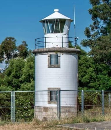
1900 (station established 1844). Active; focal plane 37 m (121 ft); white light, 5.3 s on, 2.4 s off, 2.2 s on, 2.4 s off, 5.3 s on, 2.4 s off. 9 m (30 ft) round tower with lantern and gallery, painted white. A photo by Juan Tiagues is at right, Trabas has an excellent photo by Da Palma that shows that the tower is nowhere near the 21 m (69 ft) height listed by NGA and by Puertos del Estado, a 2021 photo is available, Loly Mato Pedrido has a 2022 photo, José Carlos Gago has a 2018 photo of the lighthouse in action, and Google has a good street view and a satellite view. Huelse has a historic postcard view showing a small attached cottage and a secondary lantern, both of which have been removed. Located on a promontory at the end of the Calle del Doctor Corbal in La Guía, a neighborhood northeast of Vigo on the south side of the Ría de Vigo. Site open, tower closed. Operator: Autoridad Portuaria de Vigo. . ARLHS SPA-172; ES-05010; Admiralty D1901.5; NGA 3012.
La Guía Light
La Guía Light, Vigo, July 2013
Flickr Creative Commons photo by Juan Tiagues

Illas Cíes Lighthouses
The Illas (Islas) Cíes are three steep, rocky islands arranged north to south off the entrance to the Ría de Vigo: Illa Monteagudo on the north, Illa de Faro in the center, and Illa de San Martiño in the south.

Illa Boeiro (Agoeiro)
Date unknown. Active; focal plane 23 m (75 ft); two red flashes every 8 s. 6 m (20 ft) round stone tower, painted white with a thin red band at the top. Trabas has Da Palma's distant view, another view is available, and Google has a satellite view. Located on a skerry off the south end of the Illa de San Martiño. Accessible only by boat. Site open, tower closed. ARLHS SPA-014; ES-04755; Admiralty D1889; NGA 2932.
Cabo Vicos (Farol dos Bicos)
Date unknown. Active; focal plane 94 m (308 ft); three red flashes every 9 s. 7 m (23 ft) round stone tower with gallery; the lantern has been replaced by a short round light tower with the light on top. The tower is unpainted white stone; light tower painted red. Fernando Sacó has a closeup street view, Helena Blein has a closeup photo, Trabas has Jim Smith's photo of the light in action, and Google has a satellite view. Located on the steep southeastern tip of the Illa de San Martiño. Accessible by what must be a challenging hiking trail. Site open, tower closed. ARLHS SPA-054; ES-04750; Admiralty D1888; NGA 2928.
* Punta Canabal ("Farol da Porta")
1918. Active; focal plane 63 m (207 ft); three white flashes every 20 s. 10 m two-stage cylindrical tower, with a narrow column mounted atop a circular 1-story equipment room. Tower painted white with a narrow blue horizontal band. Patricia Rejas has a 2022 closeup photo, Wikimedia has a photo, Trabas has Da Palma's photo, J.A. Alcaide has a photo, Fernando Sacó has a closeup street view, and Google has a satellite view. Located at the southern end of Isla del Faro, marking the passage between that island and the Isla de San Martiño. Accessible by hiking trail. Site open, tower closed. Operator: Autoridad Portuaria de Vigo. Site manager: Parque Natural de las Islas Atlánticas. ARLHS SPA-201; ES-04745; Admiralty D1886; NGA 2924.
* Monte del Faro (Islas Cíes)
1853 (partially rebuilt in 1978-80). Active; focal plane 185 m (607 ft); two white flashes every 8 s. 10 m (33 ft) cylindrical granite tower with lantern and double gallery. Tower is unpainted; lantern painted white. Square 1-story granite keeper's house, also unpainted but with white trim. A photo is at right, Trabas has Da Palma's photo, Mario Sánchez Prada's photo gives a good view of the peak and lighthouse, Wikimedia has a closeup photo, Sebastian Felix has a 2022 photo, and Google has a good satellite view. According the Puertos del Estado, the work in 1978-80 was "adapting the tower of the previous" light to accommodate a new rotating system; this probably means the tower was extended with a new lantern and the upper gallery. The lighthouse stands atop a sharp peak and is reached by a steep road having many switchbacks. The islands are part of a national park, accessible at least in the summer by passenger ferries from Cangas and from Vigo. Located at the highest point of Isla del Faro. Site open, tower closed. Operator: Autoridad Portuaria de Vigo. Site manager: Parque Natural de las Islas Atlánticas. ARLHS SPA-181; ES-04740; Admiralty D1884; NGA 2920.
* Monte Agudo
1904. Active; focal plane 24 m (79 ft); green flash every 5 s. 5 m (16 ft) cylindrical equipment room with gallery; the light is displayed from a short mast. Access to the gallery is by a stairway that spirals around the tower. A circular wall surrounds the light. All structures painted white. A 2016 photo is available, Trabas has Da Palma's photo, Wikimedia has a closeup photo, Javier Fernández has a 2022 photo, and Google has a street view and a satellite view. Located on the northeast coast of Isla Monteagudo, the northernmost of the three Islas Cíes (see next entry). Accessible by a hiking trail from Isla del Faro to the south (the two islands are joined by a sandbar). Site open, tower closed. Site manager: Parque Natural de las Islas Atlánticas. Operator: Autoridad Portuaria de Vigo. ARLHS SPA-244; ES-04730; Admiralty D1882; NGA 2916.

Monte del Faro Light, Illas Cíes, August 2015
Wikimedia Creative Commons photo by Banjo

Pontevedra District Lighthouses

Ría de Vigo North Side Lighthouses
* Cangas Inner Mole (1?)
Date unknown. Inactive since 2011. This was a 6 m (20 ft) square stone tower painted white with unpainted stone trim. Trabas has a closeup photo by Da Palma and Google has a satellite view. The active light (focal plane 2 m (7 ft); three red flashes, in a 2+1 pattern, every 15 s) has been moved to a small lamp mounted on the end of the breakwater. Located at the end of the main breakwater mole at Cangas, on the north side of the Ría de Vigo. Accessible by walking the mole. Site open, tower closed. Active light: ES-04850; Admiralty D1895.4; NGA 2968.
Con de Pego
Date unknown. Active; focal plane 9 m (30 ft); four red flashes every 11 s. 8 m (26 ft) round concrete tower on a square concrete base. Tower painted red, base white. Trabas has Meyer's photo, Lino Portela has a 2020 photo, and Google has a satellite view. Located on a reef on the north side of the channel of the Ría de Vigo. Accessible only by boat. Site open, tower closed. Operator: Autoridad Portuaria de Vigo. ES-04870; Admiralty D1895.6; NGA 3016.
Punta Borneira
Date unknown. Active; focal plane 13 m (43 ft); two red flashes every 7 s. 11 m (36 ft) round 2-stage stone tower with gallery. Upper stage painted red, lower stage white. A photo is at right, Trabas has Da Palma's photo, Carlos Moldes Fernández has a 2017 closeup, and Google has a satellite view. Located in the Ría de Vigo about 7 km (4 mi) west of the Vigo waterfront. Accessible only by boat. Site open, tower closed. Operator: Autoridad Portuaria de Vigo. ES-04800; Admiralty D1892; NGA 2960.
Punta Borneiro Light
Punta Borneira Light, Vigo, September 2007
Flickr Creative Commons photo by davidcmg
* Cabo del Home Posterior (Range Rear) (Punta Subrido)
Date unknown. Active; focal plane 53 m (174 ft); white light, 4.3 s on, 1.7 s off. 13 m (43 ft) round masonry tower with gallery; the light is displayed from a short mast. A column behind the mast blocks visibility of the light from directions other than the northwest. Tower painted white. Trabas has a fine photo, María Jesús Serrano has a 2021 photo, Olivier Cruces Robineau has a 2016 closeup, Lisardo Vilar has a street view, and Google has a satellite view. This is an approach range for vessels arriving in Vigo from the northwest. Located on the eastern point of the two points of Cabo del Home, about 8 km (5 mi) due west of Cambados and 815 m (1/2 mi) east southeast of the front light. Site open, tower closed. Operator: Autoridad Portuaria de Vigo. . ARLHS SPA-024; ES-04761; Admiralty D1876.1; NGA 2912.
* Punta Robaleira
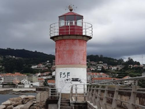
Date unknown. Active; focal plane 29 m (87 ft); two flashes every 7.5 s, white or red depending on direction. 6 m (20 ft) short round masonry tower atop a round 1-story masonry equipment room. Tower painted red with white trim. Mathieu Capronnier's photo is at the top of this page, Trabas has a good closeup photo, Isaac Peña's October 2007 photo and Miguel Gil Lago's 2017 closeup both show a freshly painted tower, Mathieu Capronnier has a lovely street view, and Google has a satellite view. Located at the extreme southern tip of the western point of the two points of Cabo del Home, about 8 km (5 mi) due west of Cambados and only 300 m (330 yd) south of the Cabo del Home Anterior light. Site open, tower closed. Operator: Autoridad Portuaria de Vigo. . ES-04770; Admiralty D1874; NGA 2904.
* Cabo del Home Anterior (Range Front)
Date unknown. Active; focal plane 38 m (125 ft); white light, 1.3 s on, 1.7 s off. 19 m (62 ft) round masonry tower with gallery; the light is displayed from a short mast. Tower painted white with blue trim. Abel Borrajo's photo is at right, Trabas has a good closeup photo, Marco Antonio García Elena has a 2022 photo, Olivier Guiberteau has a 2018 closeup, and Google has a street view and a satellite view. This light and the Cabo del Home Posterior light form a range guiding ships into the northern entrance to the Ría de Vigo. Located on the western point of the two points of Cabo del Home, about 8 km (5 mi) due west of Cambados. Operator: Autoridad Portuaria de Vigo. Site open, tower closed. . ARLHS SPA-331; ES-04760 Admiralty D1876; NGA 2908.

Cabo del Home Range Front Light, January 2010
ex-Panoramio photo copyright Abel Borrajo; permission requested

Ria de Pontevedra Lighthouses
* Punta Couso
Date unknown. Active; focal plane 20 m (66 ft); three flashes every 10.5 s, white or green depending on direction. 5 m (16 ft) round stone tower with gallery; the light is displayed from a short mast. Tower painted white with a narrow green band at the top. Trabas has a photo, Carlos Gago Dorna has a 2019 photo, Diego Acevedo has a street view, and Google has a satellite view. Located on a sharp promontory at the entrance to the Baía Golfeira just south of the entrance to the Ría de Pontevedra and about 8 km (5 mi) northwest of Cambados. Site open, tower closed. Operator: Puerto de Marín. . ARLHS SPA-204; ES-04710; Admiralty D1873; NGA 2896.
Bajo Cabezo de la Mourisca
Date unknown. Active; focal plane 12 m (39 ft); two green flashes every 7 s. 12 m (39 ft) round stone tower, painted white with a green band at the top. Trabas has a photo, Jose Carlos Gago has a 2022 photo, and Google has a satellite view. Located off Cabo Udra on the south side of the Ría de Pontevedra entrance about 8 km (5 mi) northeast of Punta Couso. Accessible only by boat. Site open, tower closed. Operator: Puerto de Marín. ES-04590; Admiralty D1872; NGA 2888.
Isla Tambo (Punta Tenlo Chico)
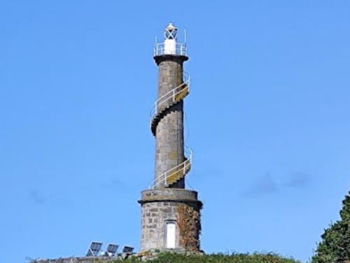
1922. Active; focal plane 35 m (115 ft); white light occulting three times every 8 s. Approx. 13 m (43 ft) narrow round stone tower mounted on a round 1-story stone equipment room. There is a small lantern and gallery accessed by an external stairway that spirals around the tower. Tower is unpainted dark gray stone; lantern is a lighter gray. A view from the bay by Juan Tiagues is at right, Trabas has a photo, another photo is available, Spanish Wikipedia has a distant view, and Google has a closeup street view, but the area is blurred in Google's satellite view. The wooded Isla de Tambo, a nature reserve, is located in the middle of the Ría de Pontevedra about 2 km (1.2 mi) north of Marín. Located on the southern tip of the island. Accessible only by boat. Site open, tower closed. Operator: Puerto de Marín. ARLHS SPA-159; ES-04630; Admiralty D1860; NGA 2856.

Isla Tambo Light, Marín
Puerto de Marín photo
** Isla de Ons (Illa de Ons) (2)
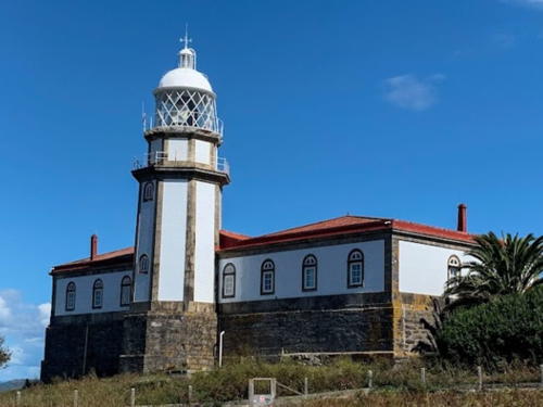
1926 (station established 1865). Active; focal plane 127 m (417 ft); four white flashes every 24 s. 12 m (39 ft) octagonal stone tower with lantern and double gallery, attached to the rear of a U-shaped 1-story keeper's house. 1st order Fresnel lens in use. Buildings painted white with unpainted stone trim; the trim on the tower gives the impression of gray vertical stripes. Lantern dome is gray metallic; roof of the house is red. Francisco Méndez García's photo is at right, Leonardo Pigozzo has a 2023 photo, Marcos González has a good photo, Valentín Guisande Sancho has a fine 2016 photo, Trabas has Meyer's distant view, Fernando Sacó has a street view, and Google has a satellite view. The current lighthouse is built on the foundation of the original. The Illa de Ons is the largest island of Spain's Atlantic coast, about 7 km (4 mi) long from north to south and located about 8 km (5 mi) west of the entrance to the Ría de Pontevedra. The island is accessible, at least in the summer, by passenger ferry from Sanxenxo. In 2002 the island was included with several others in a new national park. The lighthouse is located at the center of the island, which is also the highest point. Site open, tower said to be open by arrangement with the resident caretaker. Operator: Puerto de Marín. Site manager: Parque Natural de las Islas Atlánticas. . ARLHS SPA-154; ES-04520; Admiralty D1847.3 (ex-D1846); ex-NGA 2832.
Bajo de los Camoucos (Illote Torre de Camouxo)
Date unknown. Active; focal plane 12 m (39 ft); three red flashes every 18 s. 13 m (43 ft) round stone tower with gallery, painted white with a red band around the top. An excellent closeup photo is available, Trabas has Meyer's distant photo, and Google has a satellite view. This light and the Bajo Picomillo light (next entry) guide vessels through the passage between the mainland and the north end of the Isla de Ons. Located about 800 m (1/2 mi) off the northeastern tip of Illa de Ons. Accessible only by boat. Site open, tower closed. Operator: Puerto de Marín. ES-04540; Admiralty D1848; NGA 2840.

Isla de Ons Light, September 2022
Google Maps photo by Francisco Méndez García

O Salnés District Lighthouses

Ria de Pontevedra North Side Lighthouses
* Sanxenxo
Date unknown. Active; focal plane 7 m (23 ft); red flash every 5 s. 6 m (20 ft) round concrete tower with lantern and gallery. Trabas has Da Palma's photo, Jose Carlos Gago has a photo of the light in action, Maria Nina Nunes has a 2023 photo, and Google has a satellite view. NGA spells the name as Sangenjo. Located on a marina wharf at Sanxenxo, a resort town on the north side of the lower Ría de Pontevedra. Accessible by walking the pier. Site open, tower closed. ES-04600; Admiralty D1856; NGA 2852.
Bajo Picamillo (2)
2018 (station establishment date unknown). Active; focal plane 10 m (33 ft); green flash every 5 s. 13 m (43 ft) round stone tower with gallery, painted white with a green band around the top. Trabas has Meyer's photo and Google has a satellite view. The original lighthouse, seen in a closeup photo by Francisco José Tébar Salas, was overturned by a severe winter storm in early February 2017. The replacement tower was announced by the Admiralty in December 2018. Located midway in the Canal de Faxilda, the passage between the mainland and the north end of the Illa de Ons. Accessible only by boat. Site open. Operator: Puerto de Marín. ES-04560; Admiralty D1850; NGA 2844.

Ria de Arousa South Side Lighthouses
Bajo Pombeiriño
Date unknown. Active; focal plane 15 m (49 ft); two green flashes every 12 s. 14 m (46 ft) round stone tower with gallery, painted white with a green band around the top. There appears to be a watch room space below the gallery. Trabas has Meyer's photo, Jose Miguel Perelló March has a very distant street view from shore, and Google has a satellite view. Located on the south side of the entrance to the Ría de Arousa, about 1 km (0.6 mi) off the Barrio Carreiro northwest of Piedras Negras. Accessible only by boat. Site open, tower closed. Operator: Porto de Vilagarcía. ARLHS SPA-281; ES-04150; Admiralty D1800; NGA 2740.
Bajo Con de Estro (Piedras Sálvores)
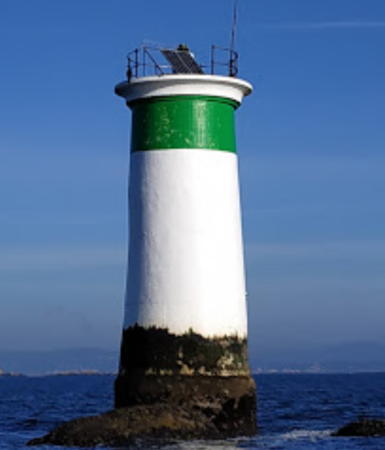
Date unknown. Inactive since the 1990s. Approx. 10 m (33 ft) round stone tower with gallery, painted white with a green band around the top. A photo is at right, Jose Carlos Gago has a 2021 photo, and Google has a satellite view. This former light is still maintained as a daybeacon. Located in the Ría de Arousa about 1.6 km (1 mi) off the entrance to the small harbor of Meloxo. Accessible only by boat. Site open, tower closed. Operator: Porto de Vilagarcía. ES-04510.
Bajo Golfiera
Date unknown. Active; focal plane 11 m (36 ft); quick green flash every 1 s. 10 m (33 ft) round stone tower with gallery, painted white with a green band around the top. Trabas has Da Palma's phot, Carlos Gago Dorna has a 2021 photo, and Google has a satellite view. This light and the next one frame the entrance to Cambados. Located about 1 km (0.6 mi) north of the harbor of O Grove on the south side of the Ría de Arousa. Accessible only by boat. Site open, tower closed. Operator: Porto de Vilagarcía. ES-04440; Admiralty D1810; NGA 2824.
Bajo Lobeira de Cambados
Date unknown. Active; focal plane 11 m (36 ft); three red flashes every 9 s. 10 m (33 ft) round stone tower with gallery, painted white with a red band around the top. Trabas has Da Palma's photo and Google has a satellite view. This light and the previous one frame the entrance to Cambados. Located about 1 km (0.6 mi) due north of the Bajo Golfiera light. Accessible only by boat. Site open, tower closed. Operator: Porto de Vilagarcía. ES-04450; Admiralty D1808; NGA 2812.
Bajo Praguero de Fuera
Date unknown. Active; focal plane 10 m (33 ft); four green flashes every 11 s. 10 m (33 ft) round stone tower with gallery, painted white with a green band around the top. Trabas has Da Palma's photo and Google has a satellite view. Located about 1.5 km (1 mi) southeast of the south end of the Illa de Arousa. Accessible only by boat. Site open, tower closed. Operator: Porto de Vilagarcía. ES-04430; Admiralty D1806; NGA 2820.
Bajo Con de Estro Light
Bajo Con de Estro Light, August 2011
ex-Panoramio photo copyright manuimac; permission requested
Bajo La Loba
Date unknown. Active; focal plane 10 m (33 ft); two green flashes every 7 s. 10 m (33 ft) round stone tower with gallery, painted white with a green band around the top. A 2018 photo is available, Trabas has Meyer's distant view and Google has a satellite view. This light and the next one guide vessels around the extensive shoals on the west side of the Illa de Arousa. Located about 3 km (2 mi) west of the south end of the Illa de Arousa. Accessible only by boat. Site open, tower closed. Operator: Porto de Vilagarcía. ES-04210; Admiralty D1816; NGA 2748.
Bajo Piedra Seca
Date unknown. Active; focal plane 12 m (39 ft); three green flashes every 9 s. 12 m (39 ft) round stone tower with double gallery, painted white with a green band around the top. Trabas has Meyer's distant view, and Google has a satellite view. Located in the center of the Ría de Arousa, about 1.2 km (3/4 mi) east of the Isla de Rua. Accessible only by boat. Site open, tower closed. Operator: Porto de Vilagarcía. ES-04220; Admiralty D1824; NGA 2752.
** Punta Cabalo (Illa de Arousa)
1853. Active; focal plane 13 m (43 ft); four white flashes every 13 s. 5 m (16 ft) octagonal stone tower with lantern and gallery, attached to the front of a square 1-story keeper's house; modern 500 mm lens. Tower unpainted; lantern is metallic gray; house painted white with a red tile roof. A photo by Contando Estrelas is at right, Trabas has Meyer's excellent photo, Rakel Muñiz has a nice 2021 view, and Google has a street view and a satellite view. The building is a popular restaurant. The Isla de Arosa, or Illa de Arousa in Galego, is a substantial island, about 7 km (4 mi) long, on the eastern side of the Ría de Arousa. The island is accessible by a bridge on the PO-307 highway from Vilanova de Arousa. The lighthouse is on the rocky northwestern tip of the island. Site and restaurant open, tower closed. Operator: Porto de Vilagarcía. . ARLHS SPA-222; ES-04260; Admiralty D1826; NGA 2768.
* Vilagarcía (Rosa de Mar)
2008. Active; focal plane 19 m (62 ft); two green flashes every 7 s. Approx. 14 m (46 ft) blue sculpture. Carlos Abella Rey has a 2010 photo, Trabas has Da Palma's photo, a 2021 closeup is available, the Cimarq consulting engineering firm has photos, and Google has a satellite view. The work is by the Galician sculptor Xaquín Chaves; he describes it as a "metaphor of the ocean and sky." Located at the end of the quay at the entrance to Vilagarcía harbor. Site open, tower closed. Operator: Porto de Vilagarcía. ES-04378; Admiralty D1839.8.

Punta Cabalo Light, Illa da Arousa, February 2011
Flickr Creative Commons photo
by Contando Estrelas

Adjoining pages: North: Western Galicia | South: Northern Portugal

Return to the Lighthouse Directory index | Ratings key

Posted December 2, 2005. Checked and revised July 9, 2023. Lighthouses: 36. Site copyright 2023 Russ Rowlett and the University of North Carolina at Chapel Hill.