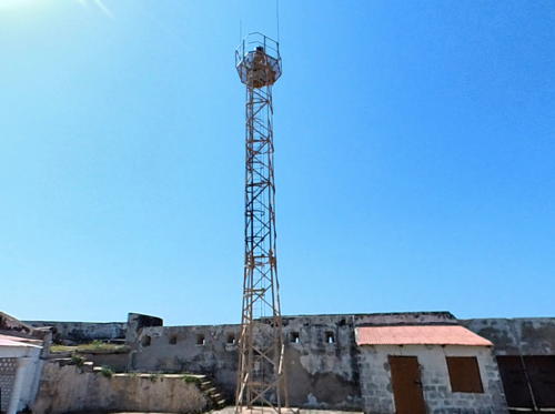
- * Cape St. Mary (2)
- Date unknown. Active; focal plane 43 m (141 ft); two white flashes every
10 s. Approx. 13 m (43 ft) square skeletal mast centered on a concrete platform supported by four robust concrete piles. Reto Müller contributed a 2013 photo, a Google 2024 street view is at right, and Google also has a satellite
view. The Admiralty and NGA say the light is on a water tower but the photo proves that it was moved to this platform in front of the water tower. As a result the focal plane may be less than the listed value. Cape St. Mary is a bluff about 3 km (2 mi) southwest of the entrance to the River Gambia. Located
facing the Atlantic Ocean in the Fajara neighborhood, about 4 km (2.5 mi)
southwest of the cape. Site open, tower closed. Admiralty D3021; NGA 24452.
- * Banjul Point
- Date unknown (probably recent). Active; focal plane 27 m (89 ft); white
light, 4 s on, 4 s off. Approx. 24 m (79 ft) square skeletal tower. No photo available but Google has a satellite view and a distant 2024 street view. The national capital city, Banjul is built on a peninsula forming
the south side of the River Gambia entrance, with the harbor sheltered on
the south side. Located at the east end of the peninsula. Site probably open,
tower closed. Admiralty D3027.5; NGA 24465.
- * [Fort James Island, Kunta Kinteh Island]
- Date unknown. Reactivated (?); charted as active by C-Map; 8 m (26 ft); listed with white flash every 14.5 s. Approx. 5 m (17 ft) square skeletal tower, painted
white. This light is back on the Admiralty list, although a closeup photo (a little over halfway down the page), a second photo, and a 2023 video show that the lamp had been removed
from the tower. Google
has a satellite view of the island and fort. Fort James is a slave traders' fort, first
built by German merchants in 1651 and captured by the British in 1661.
Abandoned with the end of the slave trade in 1779, the ruined fort is
also a UNESCO World Heritage Site. In 2011 the island was renamed for Kunta Kinteh, a Gambian portrayed in the popular U.S. television series Roots as an ancestor of the author Alex Haley. Erosion is eating away at the island
and the ruins. Located on a small island in the River Gambia about 30
km (19 mi) from the sea and 3 km (2 mi) southeast of Albreda. Accessible
only by boat; tours are available from Banjul. Site open, tower closed.
ARLHS GAM-002; Admiralty D3030; NGA 24468.
- * Barra Point (Fort Bullen) (2)
- Date unknown (station established 1863). Active; focal plane 18 m (59 ft);
three quick red flashes every 15 s. Approx. 14 m (46 ft) square skeletal tower
mounted on the northwestern rampart of Fort Bullen. Part of a 2021 street view by Matej Priteržnik is at the top of this page,
Lamin O. Beyai has a 2020 photo, Liz MacKenzie-Barrett has a view from the river, and Google has a satellite view. Built by Britain in 1826, Fort Bullen is a UNESCO World
Heritage Site. A light was displayed from a flagpole of the port beginning
in 1863 but it is not known how long this light was maintained. The present
light appears to be of modern origin. Located on Barra Point, the north side
of the entrance to the River Gambia, opposite Banjul. Site open, tower closed.
ARLHS GAM-001; Admiralty D3027; NGA 24464.
|
 Cape St. Mary Light, Fajara, May 2024
Google Maps street view by Africa 360 View
|

