Lighthouses of Greece: Crete

The nation of Greece occupies a complex peninsula at the southeastern corner of Europe plus a large number of islands in the Aegean Sea to the east and the Ionian Sea to the west. The name Greece is of Roman origin (Graecia in Latin); the traditional name of the country is Hellas (Ἑλλάς) and its official name is the Hellenic Republic (Ελληνική Δημοκρατία, Ellinikí Demokratía).

The fifth largest island of the Mediterranean, Crete (Κρήτη, Kríti) is 260 km (160 mi) long from east to west but only 13 km (8 mi) to 60 km (37 mi) in width; it separates the Aegean Sea to the north from the main portion of the Mediterranean Sea to the south. Venice governed Crete from 1212 to 1669, when the island came under the rule of the Ottoman (Turkish) Empire. During the 1800s repeated rebellions and much political maneuvering led to Crete's becoming an independent Greek republic in 1898. The Cretan Republic was unified with the Kingdom of Greece in 1913 after the end of the Balkan Wars.

The historic lighthouses of the island are often described as Venetian but most of them were built by French engineers in the early 1860s while the island was under Ottoman rule.

Greece is divided into thirteen administrative regions called periferies (περιφέρειες). Crete is one of these regions. It is subdivided into four districts called regional units (enótites, ενότητες): Chania, Rethymno, Heraklion and Lasithi.

The Greek word for a lighthouse, pháros or fáros (φάρος), is the root for the words for lighthouse in many Western European languages. In Greek nisi is an island, ýfalos is a shoal or reef, akrotíri or ákra is a cape or headland, kolpós is a bay or gulf, ekvolí is an estuary, potámi is a river, and limáni is a port or harbor.

Lighthouses in Greece are maintained by the Hellenic Navy Lighthouse Service.

ARLHS numbers are from the ARLHS World List of Lights. Admiralty numbers are from volume N of the Admiralty List of Lights & Fog Signals. U.S. NGA List numbers are from Publication 113.

General Sources
Lighthouses of Greece
A comprehensive site posted by amateur radio operator Pavlidis Savas (SV2AEL); it includes data and photos for 120 traditional Greek lighthouses.
Lighthouse Service - Photographs
A large collection of unlabeled (!) photos of lighthouses.
Online List of Lights - Greece
Photos by various photographers posted by Alexander Trabas.
Lighthouses in Greece
Aerial photos posted by Marinas.com.
Lighthouses in Greece
Photos by various photographers available from Wikimedia.
World of Lighthouses - Greece
Photos by various photographers available from Lightphotos.net.
Leuchttürme an der griechischen Küste
Photos by various photographers posted by Bernd Claußen.
Europäische Leuchttürme auf historischen Postkarten
Historic postcard images posted by Klaus Huelse.
Navionics Charts
Navigational chart for Crete.


Chania Light, Chania, October 2023
Instagram photo by Neil St. George

Chania District: Gavdos Lighthouses
Gavdos (Gávdhos) is a small island 27 km (17 mi) south of Chóra Skafion on the south coast of Crete. The island is the southernmost point of Greece and of Europe. The permanent population is only about 150 but several thousand vacationers may be present during the summer. Ferry transportation is available from Sougia and from Chóra Skafion.
* [Tripiti (Gávdhos, Ákra Tripití) (2?)]
1990. Active; focal plane 37 m (121 ft); two white flashes every 16 s. 6 m (20 ft) square skeletal tower with gallery. Lighthouse painted white. A photo shows the current light in the background behind a similar tower that has collapsed. Panos Atemlos has a distant view and Google's satellite view shows the new light and the ruins of the old one. Ákra Tripití is the southernmost tip of the island, and thus has some fame as the southernmost point of Europe. Accessible by a hiking trail. Site open, tower closed. ARLHS CRE-007; Admiralty N4840; NGA 16208.
* Gávdhos (1)
1880. Inactive since World War II. Approx. 6 m (20 ft) round masonry tower, formerly with lantern and gallery and attached to a 1-story keeper's house. Lighthouse formerly painted white. The lighthouse was largely destroyed by a German air raid in May 1942. A 1999 closeup photo is available. Claußen says the lighthouse was at the highest point of the island but other sources suggest it was close to the replica lighthouse. This Google satellite view may show it. More information needed!
*** Gávdhos (2) (replica)
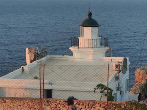
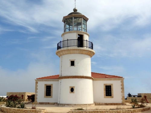
2003 reconstruction of 1880 lighthouse. Inactive. Approx. 9 m (30 ft) round masonry tower with lantern and gallery, attached to a 1-story replica of the keeper's house. Lighthouse painted white; lantern dome painted dark green. A photo is at right, Daniel Frąckowiak has a 2022 photo, Georgios Papaioannou also has a photo, a 2007 photo by Panagiotis Laskaris shows visitors on the gallery, the Cretan Beaches web site has a page for the lighthouse with photos, Nikos Kourtsidakis has a drone view, Matteo Maria Bosi has a street view, and Google has a satellite view. This replica was built during 2002-03 and is open to the public; the rebuilt keeper's house is a café and museum. Located on the southwestern coast of the island, south of the abandoned village of Ampelos. Site open, museum and tower open in season. .
Gavdos Light
Gávdhos Light replica, Gávdhos, August 2012
Flickr photo copyright gavdos012; permission requested

Chania District: Western Crete Lighthouses
Chania (Χανιά) is a city of about 110,000 residents and a major port in northwestern Crete. Many visitors arrive here by ferry from Piraeus (the port of Athens) or by cruise ship. The adjoining town of Souda is home to the Greek and NATO Crete Naval Base.
Nisída Megalonísi
Date unknown. Active; focal plane 67 m (220 ft); three white flashes every 20 s. 6 m (20 ft) square pyramidal white concrete tower. Trabas has a distant view, a view from the mainland is available, and Google has a distant satellite view. Located atop an island off the southwest coast of Crete. Accessible only by boat. Site status unknown. Admiralty N4833.6; NGA 16196.
Elefónisi (Elefonisos) (2)
Date unknown (station established about 1910). Active; focal plane 43 (141 ft); three white flashes every 24 s. 15 m (49 ft) square skeletal tower with gallery, painted white. Next to the tower are the ruins of a stone keeper's house and a small stone chapel. A photo is at right, Tomáš Godula has a 2018 photo, Stephan Meise has a 2017 street view, Trabas has a distant view from the mainland, and Google has a satellite view. According to Savas's text, a lighthouse was built after the Austrian liner Imperatrix wrecked on nearby reefs in February 1907. The original lighthouse was a tall stone tower. Located on an island just off the southwestern tip of Crete. Accessible only by boat. Site status unknown. ARLHS CRE-006; Admiralty N4778; NGA 16224.
Gramvoúsa (2)
Date unknown (station established 1874). Active; focal plane 108 m (354 ft); red flash every 10 s. 4 m (13 ft) metal beacon on a masonry base. Beacon painted white with a red horizontal band. Trabas has Capt. Peter Mosselberger's view from the sea and Google has a satellite view. The masonry tower shown in Savas's photo seems to be an error. What is probably the foundation of the 1-story square masonry keeper's house is present, and Jaroslav Kocourek has a photo showing ruins, possibly of the original lighthouse. Gramvoúsa is a pair of islands off the northwestern tip of Crete. Located at the northwestern tip of Agria Gramvoúsa, the northern island of the pair. Accessible only by boat. Site status unknown. ARLHS CRE-013; Admiralty N4780; NGA 16008.

Elefónisi Light, Elefónisi, March 2018
Google Maps photo by Bruno

* Chania (Khaniá, Khanion)
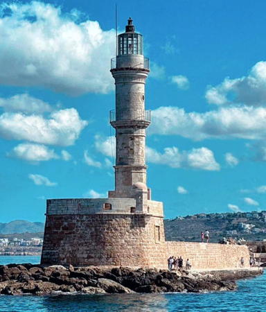
1864 (station established by Venice in the 15th century). Active; focal plane 26 m (85 ft); red flash every 2.5 s. 26 m (85 ft) round cylindrical stone tower with lantern and gallery, mounted on a much older stone base. The light is now displayed from the top of the lantern. The entire lighthouse is unpainted white stone; lantern painted white. Neil St. George's photo is at the top of this page, Trabas has a closeup by Peter Doll, Marv Baker has a 2022 photo, Stavros Markopoulos has a 2008 photo, Wikimedia has photos, the Navy has a sunset photo, Huelse has a historic postcard view, Minos Nevradakis has a street view, and Google has a satellite view. The port of Chania (Χανιά) was built by Venice on the site of the ancient town of Kydonia, and the stone base of this lighthouse is part of the 15th century Venetian lighthouse. In recent years Chania has become a popular cruise ship port, making this one of the best-known and most-often-photographed Greek lighthouses. Savas's photos show that it was in poor condition by the late 1990s. In 2006 a thorough restoration was carried out; Martin Belam's photo taken on 2 May 2006 shows the lighthouse with its lantern removed and the tower wrapped in scaffolding. Located at the end of the breakwater mole on the east side of the entrance to Chania harbor, near the northwestern corner of Crete. Site open, tower closed. . ARLHS CRE-004; Admiralty N4781; NGA 16012.
[Ákra Maléka]
Date unknown. Active; focal plane 48 m (157 ft); two white flashes every 12 s. 6 m (20 ft) square skeletal tower. No photo available; the shadow of the tower is barely visible in Google's satellite view. Located atop a vertical cliff on Cape Maleka, about 25 km (15 mi) northeast of Chania. Site and tower closed (restricted military area). Admiralty N4783; NGA 16024.
[Nisis Soúdhas (Suda Island) (2?)]
Date unknown (station established 1864). Active; focal plane 20 m (66 ft); green flash every 4.8 s. 5 m (17 ft) square pyramidal skeletal tower, painted white and enclosing a small equipment shelter; the shelter is painted white with a green band at the top. Trabas has Hartmut Knape's photo, Christer Osterman has a view from the sea, and Bing has a satellite view. Soúda Island is on the north side of Soúda (Suda) Bay, an important Greek and NATO naval base. The first lighthouse here had a focal plane of 25 m (82 ft). Located atop a historic fort at the southern tip of the island. Accessible only by boat. Site status unknown. ARLHS CRE-011; Admiralty N4786; NGA 16040.
Drépano (Drepanon) (2)
1948 (station established 1864). Active; focal plane 56 m (184 ft); three white flashes every 30 s. 7 m (23 ft) octagonal stone tower with lantern and gallery, attached to a 1-story stone keeper's house. The lighthouse is white; lantern dome is dark green. Arno Siering's photo is at right, Trabas has a fine closeup, Marita Kaloglou has a 2020 photo, Barbara Perillo has a 2023 view, and Google has a satellite view. The original lighthouse was destroyed by German troops during World War II, but the present lighthouse is a copy. The 2017 photo shows that it has been restored recently. Ákra Drépano is on the south side of the entrance to Soúda (Suda) Bay. Savas claims the site takes three hours to reach but the lighthouse is only 2.5 km (1.5 mi) northeast of Kokkino and is accessible by a primitive road. Site appears open, tower closed. . ARLHS CRE-014; Admiralty N4784; NGA 16036.
Drepano Light
Drepano Light, Kokkino
photo copyright Arno Siering; used by permission

Réthymno District Lighthouses
Réthymno (Ρέθυμνο) is a ferry port on the west central north coast of Crete. An ancient city with many archeological sites, Réthymno has a population of about 40,000 today.
* [Réthymno North Mole]
Date unknown. Active; focal plane 10 m (33 ft); green flash every 3 s. 8 m (26 ft) post centered on a hexagonal 1-story equipment shelter. Lighthouse painted white with one green band around the post. Trabas has a photo by Rainer Arndt, Marcus Normann has a street view, and Google has a satellite view. Located at the end of the north mole (the main breakwater) of Réthymno harbor. Accessible by walking the pier. Site open, tower closed. Admiralty N4790; NGA 16064.
* Réthymno (Rethymnon, Rethimnon, Rethimno)
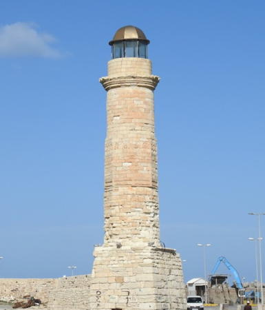
1864. Inactive for many years. 16 m (52 ft) stone tower with lantern and gallery, mounted on a square stone base at the end of a stone fortification. The lower 2/3 of the tower is octagonal and the upper 1/3 is round. The lighthouse is unpainted; the lantern is dark metallic. Tanya Dedyukhina's photo is at right, Alistair Young has a closeup, Vasile Pop has a 2022 photo, a 2010 photo and a 2023 photo are available, Wikimedia has several photos, and Google has a street view and a satellite view. Endangered. The lighthouse has clearly been abandoned for some time and the gallery rail is missing. The active lights have been moved to the ends of outer breakwaters enclosing a harbor much larger than the original. This lighthouse is second only to Chania as the most photographed lighthouse on the island. Located on the north mole of the old inner harbor of Rethymno, now used as a small boat harbor. Accessible by walking the mole. Site open, tower closed. . ARLHS CRE-009.
* [Réthymno South Mole]
Date unknown. Active; focal plane 12 m (39 ft); red flash every 4 s. 7 m (23 ft) post centered on a hexagonal 1-story equipment shelter. Lighthouse painted white with one red band around the post. Trabas has a photo by Rainer Arndt and Google has a satellite view. Located at the end of the south mole (a broad quay) of Réthymno harbor. Accessible by walking the pier. Site open, tower closed. Admiralty N4791.4; NGA 16068.
Khondros Kavos (Panormos)
Date unknown. Active; focal plane 57 m (187 ft); flash every 6 s, white or red depending on direction. 4.5 m (15 ft) round lantern, painted white, mounted on a concrete pad. Trabas has a photo, Alexandros Roniotis has a 2017 photo, Alexander Christoph has a photo, Benjamin Kunst has a 2022 closeup, and Google has a satellite view. Located on a headland near the village of Panormos, about 18 km (11 mi) east of Rethymno. Site open, tower closed. Admiralty N4792; NGA 16076.

Réthymno Light, Réthymno, September 2012
Wikimedia Creative Commons photo
by Tanya Dedyukhina

Heraklion District Lighthouses
Heraklion (Ηράκλειο; also spelled Iráklion and Herakleion) is the capital and largest city of Crete, with a population of about 170,000.
* Heraklion (Iráklion, Candia, Megalo Kastron)
1864. Inactive for many years. This was originally an approximately 12 m (40 ft) octagonal cylindrical stone tower with lantern and gallery, mounted at the northeast corner of a 16th century Venetian fortress. A photo is at right, a 2009 photo and an excellent August 2006 photo are available, Huelse has a historic photo, Michail Paschalidis has a closeup street view, and Google has a satellite view. The lighthouse has been truncated to a height of about 6 m (20 ft) above the parapet, although the top of the stump is about 15 m (49 ft) above ground level. The fortress, known as Koules or Rocca al Mare, dominates the harbor of the city, which became the first Venetian outpost in Crete in 1204. Located on the north breakwater mole of Heraklion. Site and fortress open, tower closed. ARLHS CRE-008.
* Heraklion Outer (North) Breakwater
Date unknown. Active; focal plane 14 m (46 ft); green light, 2 s on, 4 s off. 12 m (39 ft) post centered on a hexagonal 1-story concrete equipment room. The lighthouse is unpainted. Trabas has Rainer Arndt's photo, Matěj Šarina has a 2021 photo, Thomas Grashei has a street view, and Google has a satellite view. Located at the end of the long breakwater mole at Heraklion. Accessible by walking the mole. Site open, tower closed. Admiralty N4798; NGA 16100.
Heraklion Pier 6 (South Breakwater)) (1)
Date unknown. Replaced. 10 m (33 ft) round cylindrical concrete tower topped by a circular harbor control room; the light was centered on the roof of the building. Lighthouse painted white. Google has a satellite view. The active light (red light, 2 s on, 4 s off) is now on a mast; Trabas has Hartmut Knape's photo. Located at the end of the easternmost pier at Heraklion. Site status unknown. Active light: Admiralty N4800; NGA 16104.
Heraklion Light
Heraklion (Rocca al Mare) Light, Heraklion, August 2005
Flickr Creative Commons photo by phileole
Ákra Stavrós (Nisída Día)
Date unknown. Active; focal plane 129 m (423 ft); white flash every 6 s. 4 m (13 ft) round white lantern. Trabas has Rainer Arndt's distant view from the sea and Google has a satellite view. Located on the southern cape of Día, a barren island about 15 km (9 mi) northeast of Heraklion harbor. Accessible only by boat. Site status unknown. Admiralty N4812; NGA 16092.

Lasithi District (Eastern Crete) Lighthouses
Ágios Ioánnis (Cape St. John) (1)
1864. Inactive for many years. 9 m (30 ft) round stone tower with lantern and gallery, attached to a ruined 1-story stone keeper's house. The lighthouse is unpainted; the lantern was formerly painted white with a metallic dome. The active light (focal plane 49 m (161 ft); two white flashes every 12.8 s) is on a post on the slope above the lighthouse. A photo by Tony Cross is at right, Marita Kaloglou has a 2020 photo, Keith Poole has a 2016 photo, Nikos Halkiadakis has a 2017 photo, Trabas has a good photo by Rainer Arndt, and Google has a satellite view. Critically endangered by neglect and vandalism. The lantern dome blew off in a storm in late 2008, leaving the tower open to the elements; the lens and rotating mechanism were stolen shortly thereafter. Ákra Ágios Ioánnis is a prominent cape at the northern entrance to the Gulf of Mirambéllou in northeastern Crete. The photo at the bottom of Savas's page is not of this cape. The lighthouse is at the end of knife-edged ridge and is difficult to access by land. Located on the point of the cape, about 25 km (15 mi) north of Ágios Nikólaos. Site open, tower closed. ARLHS CRE-003. Active light: Admiralty N4814; NGA 16124.
Ágioi Pandes (Ágios Nikólaos, St. Nicholas)
Date unknown. Active; focal plane 24 m (79 ft); white flash every 3 s. 7 m (23 ft) square pyramidal skeletal tower, painted white, mounted on a square stone base. 1-story keeper's house and other light station buildings. Antonios Mavridis has a view from the sea, Trabas has a distant view, and Google has a satellite view. Located on the northern tip of the island of Ágioi Pandes ("All Saints"), marking the entrance to the harbor of Ágios Nikólaos. Accessible only by boat. Site open, tower closed. Admiralty N4816; NGA 16128.
Ágios Nikólaos Jetty
Date unknown. Active; focal plane 10 m (33 ft); red flash every 2 s. 8 m (26 ft) post centered on a hexagonal 1-story equipment shelter. Lighthouse painted white with one red band around the equipment shelter. Trabas has a photo and Google has a satellite view and a street view across the harbor entrance. Located at the end of the jetty of Ágios Nikólaos. Site open, tower closed. Admiralty N4818; NGA 16132.
Faros Ágios Ioánnis
Ágios Ioánnis Light, February 2010
Contributed photo copyright Tony Cross; used by permission
[Ákra Vamvakiá (2?) (Cape Sitia)]
Date unknown (station established 1892). Active; focal plane 24 m (79 ft); three white flashes every 18 s. 5 m (17 ft) skeletal tower. Adjacent to this modern light is a ruined 1-story stone keeper's house. Trabas has Rainer Arndt's photo, another photo is available, and Google has a satellite view. Located at the tip of a promontory about 4 km (2.5 mi) northeast of Sitía. Site open, tower closed. Admiralty N4820; NGA 16140.
Cape Sidero (Ákra Sídhero) (2)
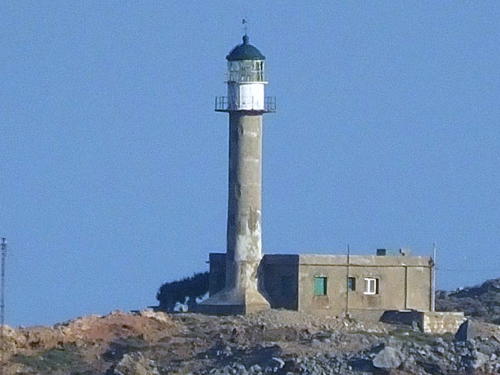
1948 (station established 1880). Active; focal plane 45 m (148 ft); white flash every 10 s. 15 m (49 ft) round cylindrical concrete tower with lantern and gallery, attached to a 1-story concrete keeper's house. The tower is unpainted white concrete; lantern painted white with a dark green dome. The original lighthouse was destroyed during World War II. Trabas has Capt. Peter Mosselberger's photo (seen at right), Takis Oikonomou has a short 2023 video, a 2012 photo is available, Wolfgang Kistler has a photo of oil being unloaded at the lighthouse in 1968, and Google has a satellite view. Note: there is another Faros Sídhero on Kérkyra (Corfu) off the west coast of Greece. This lighthouse marks Ákra Sídhero, the northeastern tip of Crete. The cape is on an island connected tenuously to a second island, which in turn is connected tenuously to the mainland. There is a road snaking out to the lighthouse, and apparently this road is open to the public. Site open, tower closed. ARLHS CRE-010; Admiralty N4826; NGA 16160.

Information available on lost lighthouses:

Notable faux lighthouses:


Cape Sidero Ligh
photo copyright Capt. Peter Mosselberger; used by permission

Adjoining pages: North: Aegean Islands | West: Southern Greece

Return to the Lighthouse Directory index | Ratings key

Posted December 31, 2006. Checked and revised October 16, 2023. Lighthouses: 17. Site copyright 2023 Russ Rowlett and the University of North Carolina at Chapel Hill.