Lighthouses of Indonesia: Southwestern Sumatra

Indonesia is a huge country of Southeast Asia, stretching along both sides of the Equator for more than 46 degrees of longitude (roughly 5100 km or 3200 miles). It occupies 17,504 islands, by official count, including more than 6000 inhabited islands. It is the world's fourth most populous nation with a population currently estinated at about 280 million. More than half of the population lives on the island of Java. Other major islands include Sumatra in the west, Borneo (shared with Malaysia and Brunei) in the northwest, Sulawesi in the northeast, and the eastern half of New Guinea in the far east. Other well known islands include Bali, Lombok, Sumbawa, Flores, and Timor (shared with independent East Timor) along the south side of the country.

The unification of the country was accomplished over many years of struggle by Dutch colonial authorities. The Dutch East India Company was founded in 1602 to establish and extend Dutch administration, and after the company folded in 1800 the Netherlands established the Dutch East Indies colony and gradually extended its boundaries to include the present territory of Indonesia. During World War II Japan occupied the islands from March 1942 to the end of the war in 1945. The Republic of Indonesia proclaimed its independence immediately after the war ended and following some conflict the Netherlands accepted the country's independence in 1949.

Sumatra (Sumatera in Indonesian) is the world's sixth largest island and the westernmost of the major islands of Indonesia. It is separated from Malaysia to the north by the Malacca Strait, from Kalimantan (Borneo) to the northeast by the broad Karimata Strait, and from Java to the southeast by the Sunda Strait. Its south coast faces the open Indian Ocean.

Indonesia is divided into 38 provinces (provinsi) and the provinces are subdivided into county units called regencies (kabupaten). Sumatra includes eight of the provinces. This page includes lighthouses of the west coast of the island including Bengkulu Province and the mainland coast of West Sumatra Province. West Sumatra Province also includes the Mentawai Islands; lighthouses of the islands are described on a separate page.

More than 700 languages are spoken in Indonesia. The official national language, Indonesian (Bahasa Indonesia), was standardized from a form of Malay that served as a lingua franca across the archipelago. In Indonesian a lighthouse is a mercusuar or a menara suar. Tanjung is a cape, ujung is a headland or point of land, bukit is a hill, sungai is a river, kuala or muara is an estuary or river mouth, pulau is an island, karang is a reef, batu is a rock, laut is a sea, selat is a strait, teluk is a bay, pelabuhan is a harbor, and labuhan is a port.

Aids to navigation in Indonesia are operated and maintained by the Directorate of Marine Navigation within the Directorate General of Sea Transportation.

ARLHS numbers are from the ARLHS World List of Lights. Admiralty numbers are from volumes F and Q of the Admiralty List of Lights & Fog Signals. (Volume F includes lights north of the Equator and Volume Q includes lights south of the Equator.) U.S. NGA List numbers are from Publication 112.

General Sources
Indonesian Lighthouses
Historic postcard views from the collection of Michel Forand.
Lighthouses in Indonesia
Photos by various photographers available from Wikimedia; most of the photos are historic.
World of Lighthouses - Indonesia
Photos by various photographers available from Lightphotos.net.
Online List of Lights - Indonesia - Volume F and Volume Q
Photos by various photographers posted by Alexander Trabas.
Navionics Charts
Navigation chart for Sumatra's west coast.

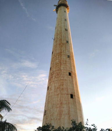
Ujung Batumandi Light, Padang, June 2012
Google Maps photo by Syamsul Putra

Bengkulu Province Lighthouses

Long and narrow, Bengkulu Province extends along the southwestern coast of Sumatra for about 525 km (330 mi). The province has a population of about 2.1 million.

Enggano Island Lighthouse
Enggano is a substantial island in the Indian Ocean, measuring roughly 30 km by 15 km (19 mi by 9 mi), about 100 km (60 mi) west of Krui. The southernmost territory of the province, it has a population of about 4100 but is rarely visited. Administratively it is a district of the North Bengkulu Regency although it is quite remote from the rest of that jurisdiction.
Pulau Enggano (Malakoni)
Date unknown. Active; focal plane 60 m (197 ft); four white flashes every 20 s. 40 m (131 ft) square white skeletal tower. No photo available but Google has a satellite view. Located on the southeast side of Malakoni, a small ferry port on the east coast of Enggano. Site probably open, tower closed. ARLHS IDO-197; Admiralty Q0895; NGA 23101.
[Pelabuhan Malakoni]
Date unknown. Active; focal plane 12 m (39 ft); white flash every 5 s. 12 m (39 ft) mast on a square platform supported by piles. Aldi Rahmayadi has a photo, Muhammad Ishaq has a distant view, the light is also seen in a short video by Agus Zuldi Hermawan, and Bing has a satellite view. Located about 200 m (220 yd) north of the pier at Malakoni. Accessible only by boat. Site open, tower closed. Admiralty Q0895.4; NGA 23101.5.

Kaur Regency Lighthouses
Tanjung Linau
Date unknown. Active; focal plane 30 m (98 ft); three white flashes every 15 s. Approx. 23 m (75 ft) square pyramidal skeletal tower, probably with lantern and gallery, painted white. No photo available but Google has a satellite view. Located on a promontory in southernmost Bengkulu province about 1 km (0.6 mi) south of the village of Linau. Site status unknown. Admiralty Q0900; NGA 23098.
Tanjung Bandar (Bintuhan)
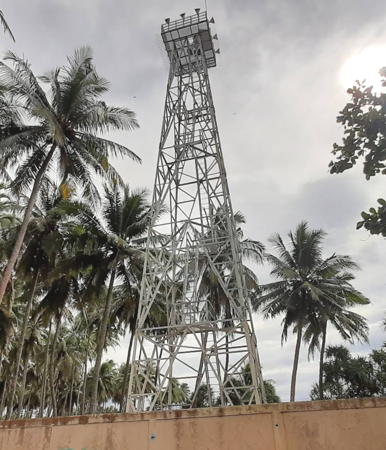
Date unknown. Active; focal plane 18 m (59 ft); white flash every 3 s. 16 m (52 ft) square pyramidal skeletal tower painted white. A photo is at right, Zoni Heriantoni has a photo, Ipung Ajo has a photo of the stairway inside the tower, and Google has a very fuzzy satellite view. The regional Navigation District has a photo taken during an inspection visit in February 2021. Apparently this is a relatively new light since it is not seen in a 2015 street view. Located on a promontory about 1 km (0.6 mi) south of Bintuhan. Site status unknown. ARLHS IDO-294; Admiralty Q0898; NGA 23099.

South Bengkulu Regency Lighthouse
Mana (Tanjung Manna)
Date unknown. Active; focal plane 30 m (98 ft); three white flashes every 15 s. Approx. 23 m (75 ft) skeletal tower with gallery, painted white. Google has a street view and Google has a satellite view. Located beside a street at the south end of Mana, the capital of the South Bengkulu Regency. Site open, tower closed. Admiralty Q0897; NGA 23100.

Tanjung Bandar Light, Bintuhan, Septembet 2016
Google Maps photo by Danles 68

Bengkulu City Lighthouse
* Pulaubaai West Breakwater (Lentera Hijau)
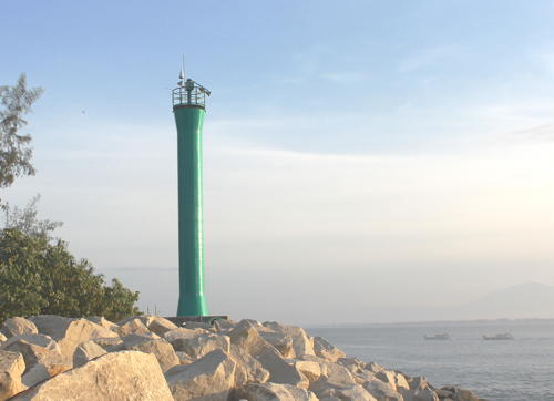
Date unknown. Active; focal plane 14 m (46 ft); green flash every 3 s. 9 m (30 ft) round barbell-shaped green tower. Arahim bin Amin Jaya has a photo (also seen at right), Hari Wibawa has a 2019 photo, Muhammad Sabri has a 2022 closeup, and Google has an indistinct satellite view. Pulaubaai is a lagoon converted into a harbor about 15 km (9 mi) south of central Bengkulu. Located on the east breakwater of the dredged entrance to the harbor. Accessible by walking the pier. Site open, tower closed. Admiralty Q0885; NGA 23102.4.
* Pulaubaai Range Front
Date unknown. Active; focal plane 8 m (26 ft); quick-flashing white light. 8 m (26 ft) round white concrete tower with gallery. Google has a street view and a satellite view. Located on the south shore of the Pulaubaai harbor. Site open, tower closed. Admiralty Q0885.5; NGA 23102.
* Pulaubaai Range Rear
Date unknown. Active; focal plane 12 m (39 ft); white flash every 3 s. 12 m (39 ft) round white concrete tower with double gallery. Edhi Sucahyo has a photo and Google has a street view and a satellite view. Located 270 m (885 ft) southeast of the front light. Site open, tower closed. Admiralty Q0885.51; NGA 23102.2.
* Pulaubaai East Breakwater (Lentera Merah)
Date unknown. Active; focal plane 14 m (46 ft); red flash every 2 s. 9 m (30 ft) round barbell-shaped red tower. Kukuh Ribudiyanto has a photo, Rendi Febriyanto has a photo, and Google has an indistinct satellite view. Located on the west breakwater of the dredged entrance to the harbor. Accessible by walking the pier. Site open, tower closed. Admiralty Q0885.2; NGA 23102.6.

West Breakwater Light, Pulaubaai, August 2015
ex-Google Plus photo by Arahim bin Amin Jaya
* Pulau Tikus (3?)
Date unknown (station established 1883). Active; focal plane 33 m (108 ft); white light, 5 s on, 5 s off. 30 m (98 ft) tapered square skeletal tower with gallery, painted white, centered on a square 1-story keeper's house. Edy Prayekno has an excellent aerial photo, Bayu Plundu has a 2018 photo, Afif Afandi has a 2019 closeup, a page for the island has several photos and Google has a satellite view. Forand has a distant postcard view of what is believed to be the second tower. The light station is reported to be staffed. Note: There is another Pulau Tikus lighthouse in West Malaysia. Located on a tiny island about 10 km (6 mi) southwest of Bengkulu; boat transportation to the island can be hired in Bengkulu. Accessible only by boat. Site open, apparently it is possible to climb the tower. ARLHS IDO-254; Admiralty Q0884; NGA 23104.

North Bengkulu Regency Lighthouse
Serengai
Date unknown. Active; focal plane 21 m (69 ft); white flash every 5 s. Approx. 12 m (39 ft) square white skeletal tower. No photo available but Google has an indistinct satellite view that may show the light; it is close to the listed location. If this is the lighthouse, however, the focal plane is higher than listed. Located on a hillside above the village of Serengai. Site status unknown. Admiralty Q0883.8; NGA 23112.
Pulau Mega (Pulau Mego)
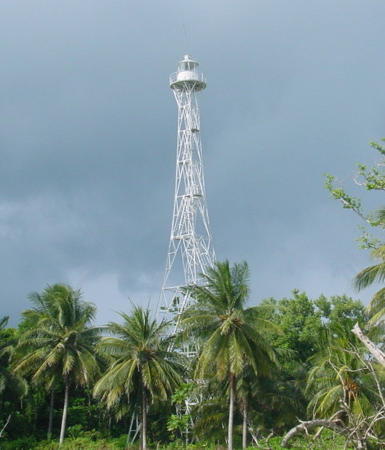
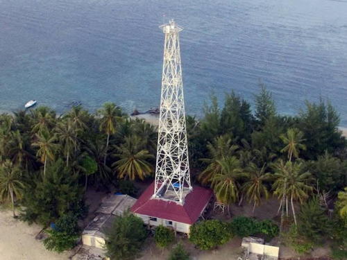
Date unknown (clearly recent). Active; focal plane 33 m (108 ft); white flash every 10 s. 30 m (98 ft) skeletal tower with gallery, painted white. The island is the site of a tectonic monitoring station installed in 2008 by Caltech University in a project aimed at measuring tectonic strains in this earthquake-prone area. One of Caltech's photos is at right and Bing has an indistinct satellite view. This light warns vessels away from the south end of reefs extending southeastward from the Mentawai Islands. Located on a small island about 160 km (100 mi) west southwest of Bengkulu. Accessible only by boat. Site status unknown. Admiralty Q0883.95; NGA 23101.7.

Pulau Mego Light, 2008
Caltech Tectonics Observatory photo

Mukomuko Regency Lighthouse
* Mukomuko (Muko-Muko)
Date unknown. Active; focal plane 25 m (82 ft); white flash every 5 s. Approx. 23 m (75 ft) skeletal tower, painted white. Google has a satellite view and a very distant street view. Located near the Mukomuko airport, at the northern end of Bengkulu province. Site status unknown. Admiralty Q0884.7; NGA 23128.

West Sumatra Province Lighthouses

Pesisir Selatan (South Pesisir) Regency Lighthouses
Muara Gadang (Airhaji Estuary)
Date unknown. Active; focal plane about 13 m (43 ft); red light, pattern unknown. Approx. 13 m (43 ft) round barbell-shaped fiberglass tower on a square platform supported by piles. A distant 2021 photo is available, Google has a distant street view, and Bing has a fuzzy satellite view. Located offshore at a small estuary entrance near Airhaji. Accessible only by boat. Site open, tower closed. Admiralty Q0884.55.
Pulau Katangkatang (3)
Date unknown (station established 1898). Inactive. 40 m (131 ft) white skeletal tower with lantern and gallery. Five 1-story coast guard buildings. No photo available but Bing has a satellite view of the station. The original lighthouse was a skeletal tower with a focal plane height of 20 m (66 ft). A second skeletal tower was built in 1923. NGA continues to describe the 1923 tower. Located on a small island about 25 km (15 mi) off the coast and about 150 km (90 mi) south of Padang. Accessible only by boat. Site status unknown.
Pulau Katangkatang (4)
Around 2021 (station established 1898). Active; focal plane about 41 m (135 ft); three white flashes every 22 s. 40 m (131 ft) octagonal concrete tower with lantern and gallery. No photo available but this new lighthouse is revealed by Bing's satellite view of the station. Located on the north side of the coast guard station. Accessible only by boat. Site status unknown. ARLHS IDO-202; Admiralty Q0884.2; NGA 23140.
Gosong Nambi
Date unknown. Active; focal plane 12 m (39 ft); white flash every 4 s. 12 m (39 ft) white concrete post with gallery mounted on a square platform supported by piles. No photo available but Bing has a satellite view. Located on a reef about 20 km (13 mi) north northwest of Pulau Katangatang. Accessible only by boat. Site open, tower closed. Admiralty Q0875.2.
Pulau Karaba Kecil
Date unknown. Active; focal plane 44 m (144 ft); three white flashes every 20 s. Approx. 40 m (131 ft) square skeletal tower with gallery. Several 1-story coast guard station buildings. Donny Saputra has a 2018 photo (a portion is seen at right), Tan Palito has a closeup, Ardian Praduba has a view from the sea and Bing has a satellite view. of the station. Located on a tiny island about 20 km (13 mi) offshore and 80 km (50 mi) south of Padang. Accessible only by boat. Site status unknown. Admiralty Q0875; NGA 23154.
Sirantih Estuary South
2017. Active; focal plane 12 m (39 ft); green flash every 5 s. 10 m (33 ft) round green fiberglass tower. No photo available but Bing has a satellite view. Located on a breakwater at the entrance to the Air Sirantih (Sirantih Estuary) at the village of Sirantih. Site status unknown. Admiralty Q0874.98.

Pulau Karaba Kecil Light, Pesisir Selatan, January 2018
Google Maps photo by Donny Saputra
Sirantih Estuary North
2017. Active; focal plane 12 m (39 ft); red flash every 5 s. 10 m (33 ft) round red fiberglass tower on a square platform. No photo available but Bing has a satellite view. Located just offshore on the north side of the entrance to the Air Sirantih. Site open, tower closed. Admiralty Q0874.97.
Pulau Batudangdang
2016. Active; focal plane 12 m (39 ft); white flash every 5 s. 10 m (33 ft) round white fiberglass (?) tower on a square platform. No photo available but Bing has a satellite view. Located on a shoal about 4 km (2.5 mi) southeast of Painan, a small port about 50 km (30 mi) south of Padang. Accessible only by boat. Site open, tower closed. Admiralty Q0874.9.
Baturimau Point (Painan Bay)
Date unknown. Active; focal plane 12 m (39 ft); white flash every 9 s. 10 m (33 ft) square pyramidal skeletal tower, painted white and mounted on a square platform supported by piles. Google has a very distant street view and Bing has an indistinct satellite view. Located just off shore at the south side of the entrance to Painan. Accessible only by boat. Site open, tower closed. Admiralty Q0874.8.
Pulau Cingkuk Besar
Date unknown. Active; focal plane 30 m (98 ft); white flash every 4 s. 20 m (66 ft) square skeletal tower painted white. Dani Pratikno has a distant street view and Google has a satellite view. Located on an island on the north side of the entrance to Painan Bay. Accessible only by boat. Site status unknown. Admiralty Q0874.5.
Pulau Simangke (Simanki Besar)
Date unknown. Active; focal plane about 14 m (46 ft); red light, pattern unknown. Approx. 14 m (46 ft) round barbell-shaped white metal or fiberglass tower mounted on a square platform supported by piles. Dekha Prima Rizkika has a 2019 photo, Fokus Budaya has a view from a nearby island, and Yohendro Nasti has a 2021 aerial view, but somehow the light escapes being shown in Google's satellite view. Located just off the north side of a small island about 5 km (3 mi) west of Painan Bay. Accessible only by boat. Site open, tower closed. Admiralty Q0874.4.
Pulau Nyamuk (Nuamuk) (2?)
Date unknown (station established 1913). Active; focal plane 32 m (105 ft); two white flashes every 10 s. 31 m (102 ft) cast iron skeletal tower, painted white. Dasril Musin has a 2022 photo seen at right and Google has a satellite view. Located on a small island (the name means Mosquito Island) about 8 km (5 mi) off the coast and about 50 km (30 mi) south of Padang. Accessible only by boat. Site status unknown. ARLHS IDO-229; Admiralty Q0874; NGA 23156.

Pulau Nyamuk Light, July 2022
Google Maps photo by Dasril Musin
Teluk Tarusan South
2016. Active; focal plane 12 m (39 ft); green flash every 5 s. 12 m (39 ft) round barbell-shaped green fiberglass tower mounted on a platform supported by piles. A closeup photo and a distant photo are available, Afif Gaziafi has a distant street view of both Teluk Tarasan lights, and Google has a satellite view. This light and the next one frame the southern entrance to Tarusan Bay. Located off a promontory on the south side of the entrance to Teluk Tarasan, a scenic sheltered bay north of Painan. Accessible only by boat. Site open, tower closed. Admiralty Q0874.3.
Teluk Tarusan North
2016. Active; focal plane 12 m (39 ft); red flash every 5 s. 12 m (39 ft) round barbell-shaped red fiberglass tower mounted on a platform supported by piles. Muhammad Luthfi has a 2022 photo, Afif Gaziafi has a distant street view of both Teluk Tarasan lights, and Google has a satellite view. Located off the east coast of Pulau Sironjong Gabang. Accessible only by boat. Site open, tower closed. Admiralty Q0874.28.
Mandeh South
2019. Active; focal plane 12 m (39 ft); green flash every 5 s. 12 m (39 ft) round barbell-shaped green fiberglass tower mounted on a platform supported by piles. Google has a satellite view and a very distant street view across the strait. This light and the next one frame the northern entrance to Tarusan Bay. Located off a promontory at the northeastern corner of Pulau Cubadak. Accessible only by boat. Site open, tower closed. Admiralty Q0874.25.
Mandeh North
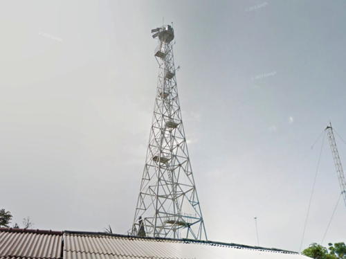
2016. Active; focal plane 12 m (39 ft); red flash every 5 s. 12 m (39 ft) round barbell-shaped red fiberglass tower mounted on a platform supported by piles. Dicky Suryadinata has a 2023 view from the bay, Google has a street view (also seen at right), and a satellite view. Located off the east coast of Pulau Sironjong Gabang. Accessible only by boat. Site open, tower closed. Admiralty Q0874.2.

Mandeh North Light, Teluk Tarusan, September 2019
Google Maps street view

Padang City Lighthouses
With a population of about one million, Padang is the capital of West Sumatra Province and the largest city on the Indian Ocean coast of Sumatra. The Dutch established a base here in 1680. The area suffered a devastating earthquake on 30 September 2009.

Pulau Bintanggar (Brintanggor)
Date unknown. Active; focal plane 116 m (381 ft); white flash every 5 s. 15 m (49 ft) square skeletal tower, painted white. No photo available but Google has a satellite view. Located on an island about 25 km (15 mi) south of Padang. Accessible only by boat. Site status unknown. ARLHS IDO-194; Admiralty Q0873; NGA 23158.
Pulau Sirandah
Date unknown. Active; focal plane 12 m (39 ft); white flash every 3 s. 12 m (39 ft) square white skeletal tower on a platform supported by piles. Perdana Sordu has a distant view, Fajri Gufran also has a distant view, and Bing has a satellite view. Located off the northern tip of Pulah Sirandah, a resort island about 3 km (2 mi) north of Pulau Brintanggar. Accessible only by boat but there's a good view from shore. Site open, tower closed. Admiralty Q0872.5; NGA 23158.5.
Gosong Gedang
Date unknown. Active; focal plane 17 m (56 ft); three quick white flashes every 6 s. 17 m (56 ft) square white skeletal tower on a platform supported by piles. No photo available but Google has an indistinct satellite view. The satellite view shows an older tower next to the active light. Located on an isolated reef about 15 km (9 mi) southwest of Padang. Accessible only by boat. Site open, tower closed. Admiralty Q0861.5; NGA 23159.
Pulau Toran
Date unknown. Active; focal plane 17 m (56 ft); white flash every 4 s. 15 m (49 ft) skeletal tower, painted white. No photo available but Google has a satellite view. Located on a small island about 25 km (15 mi) west of Padang. Accessible only by boat. Site status unknown. ARLHS IDO-255; Admiralty Q0858; NGA 23165.
Ujung Sadah (?)
Date unknown. Active(?); listed with focal plane 14 m (46 ft); green flash every 3 s. 14 m (46 ft) green skeletal tower mounted on a square platform supported by piles. No photo available and the tower is not seen in Google's satellite view or in Sandro Lesmana's view of the area. Located just off a shoal on the south shore of Teluk Bungus, a sheltered bay in the lee of Ujung Batumandi, southeast of Padang. Accessible only by boat. Site open, tower closed. Admiralty Q0852.5; NGA 23162.6.
Ujung Cino
Date unknown. Active; focal plane 14 m (46 ft); green flash every 5 s. 14 m (46 ft) green skeletal tower mounted on a platform supported by piles. No closeup photo available but Google has a satellite view. The light is barely visible to the right of the forested headland in the center of Mohamad Roghibi's distant view of the harbor. Located just off a headland on the south shore of Teluk Bungus. Accessible only by boat. Site open, tower closed. Admiralty Q0853; NGA 23162.8.
Passar Batung (Pasabatung)
Date unknown. Active; focal plane 14 m (46 ft); white (?) flash every 3 s. 14 m (46 ft) square white skeletal tower on a platform supported by piles. No closeup photo available but Google has a satellite view. The light is barely visible between the small boast and the forested headland on the left in Mohamad Roghibi's distant view of the harbor. Navionics charts this light as green. Located off the small port of Batung at the southeast corner of Teluk Bungus, about 20 km (13 mi) south of Padang. Accessible only by boat. Site open, tower closed. Admiralty Q0852; NGA 23162.4.
Ujung Pasar Cindakir
Date unknown. Active; focal plane 14 m (46 ft); red flash every 2 s. 14 m (46 ft) square red skeletal (?) tower. Rendy Sunrise has a distant view and Google has a satellite view. Located at the tip of the shoal extending from a headland on the east shore of Teluk Bungus, about 1.8 km (1.1 mi) east of Karang Sandung. Accessible only by boat. Site open, tower closed. Admiralty Q0851.5; NGA 23162.2.
Karang Sandung (2)
Date unknown. Active; focal plane 18 m (59 ft); white flash every 5 s. 18 m (59 ft) square skeletal tower mounted on a square platform supported by piles. Tower painted black with one red horizontal band. Suhendri Hasan's 2013 photo is at right and Google has a satellite view. Located on a shoal in the sheltered bay of Teluk Bungus about 2.5 km (1.5 mi) southeast of the Batumandi lighthouse. Accessible only by boat. Site open, tower closed. Admiralty Q0851; NGA 23162.
Teluk Bungus (Sandy Island)
Date unknown. Active; focal plane 17 m (56 ft); white flash every 3 s. 17 m (56 ft) round white fiberglass tower mounted on a square platform supported by piles. Cerita Dari Kampung has a 2017 photo, Cassinia Nova Sepadyaningsih has a distant street view, and Google has a satellite view. Located on the seaward side of a large reef in Teluk Bungus. Accessible only by boat. Site open, tower closed. Admiralty Q0850.5; NGA 23161.
Karang Sandung Light
Karang Sandung Light, Padang, May 2013
photo copyright Suhendri Hasan; used by permission
Pelabuhan Teluk Bungus
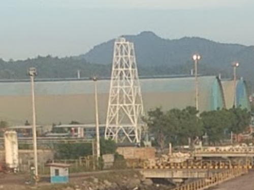
Date unknown. Active; focal plane 12 m (39 ft); white flash every 5 s. 10 m (33 ft) round barbell-shaped white tower. A photo is at right and Google has a satellite view. The Admiralty has this light listed under Pulau Karsik, an obvious mistake. Located on the wharf of a harbor on the northern corner of Teluk Bungus. Site status unknown. Admiralty Q0850.1.
*** Ujung Batumandi (Ujung Sungei Bramei, Padang) (2)
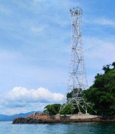
Date unknown (station established 1891). Active; focal plane 161 m (528 ft); three white flashes every 20 s. 14 m (46 ft) round concrete tower with lantern and gallery, rising from a 1-story keeper's house. Entire lighthouse is white. Syamsul Putra's 2012 photo is at the top of this page, Honggo Leo has a 2011 closeup, and Google has a street view and a satellite view. The original lighthouse was a skeletal tower with lantern. This is one of the most accessible lighthouses of the Sumatran mainland. Located just off the coastal highway on a sharp promontory about 10 km (6 mi) south of Padang. Site open, tower open but the schedule is not known. ARLHS IDO-086; Admiralty Q0864; NGA 23164.
Pulau Terlena (Karsik Reef) Northeast (2)
Date unknown. Active; focal plane about 14 m (46 ft); white light, 2 s on, 5 s off. Approx. 14 m (46 ft) round barbell-shaped white fiberglass tower. This is the white tower in Md Oliul Islam's photo and Google has a satellite view. NGA lists a beacon only 4 m (13 ft) tall. Located off the end of a sandbar in Teluk Bayur, a bay on the south side of Padang. Accessible only by boat. Site open, tower closed. Admiralty Q0870.2; NGA 23180.
Pulau Terlena (Karsik Reef) Southwest (2)
Date unknown. Active; focal plane about 14 m (46 ft); green flash every 4 s. Approx. 14 m (46 ft) round barbell-shaped green fiberglass tower. This is the green tower in Md Oliul Islam's photo and Google has a satellite view. NGA lists a beacon only 4 m (13 ft) tall. Located off the end of a sandbar in Teluk Bayur, a bay on the south side of Padang. Accessible only by boat. Site open, tower closed. Admiralty Q0870; NGA 23176.

Pelabuhan Teluk Bungus Light, Padang, Januaray 2017
Google Maps photo by al alc
Pulau Pisang (4?)
Date unknown (station established 1880). Active; focal plane unknown; white flash every 5 s. Approx. 30 m (98 ft) white skeletal tower. No current photo available but Google has a satellite view. The second light was a substantial stone tower built sometime after 1895. Possibly this lighthouse was lost in an earthquake. NGA lists a light with a focal plane of only 10 m (33 ft). Located on the southern tip of a small island about 2 km (1.25 mi) off the coast at Padang. Accessible only by boat. Site status unknown. ARLHS IDO-242; Admiralty Q0861; NGA 23184.
Pedang Estuary South
Date unknown. Active; focal plane 12 m (39 ft); green flash every 3 s. 10 m (33 ft) round barbell-shaped green fiberglass tower. Fuadi Zikri has a closeup photo, Adi Gunasusila has a photo of the two lights, Masril Rustam has a second photo of the two lights, and Google has a satellite view. Located at the northern tip of the Aperberg hill, a steep headland, marking the south side of the entrance to the Padang River opposite downtown Padang. Site open, tower closed. Admiralty Q0859.91.
Pedang Estuary North
Date unknown. Active; focal plane 12 m (39 ft); red flash every 3 s. 10 m (33 ft) round barbell-shaped red fiberglass tower. Adi Gunasusila has a photo of the two lights, Masril Rustam has a second photo of the two lights, and Google has a satellite view. Located about 200 m (220 yd) northeast of the south beacon, marking the north side of the entrance to the Padang River. Site open, tower closed. Admiralty Q0859.92.

Pariaman City Lighthouse
Pulau Karsik
Date unknown (station established 1917). Active; focal plane 32 m (105 ft); four white flashes every 15 s. 31 m (102 ft) cast iron skeletal tower, painted white. Rio Chantyno Arwanda has the 2021 photo seen at right, Andre Mantovani also has a 2021 photo plus the view from the top of the tower, and Google has a satellite view. Located on a small island about 4 km (2.5 mi) off the coast near Pariaman and about 80 km (50 mi) north of Padang. Accessible only by boat. Site status unknown. ARLHS IDO-205; Admiralty Q0850; NGA 23196.

Agam Regency Lighthouses
Ingaris
Date unknown. Active; focal plane 12 m (39 ft); two white flashes every 8 s. 12 m (39 ft) tower, form unknown, on a platform supported by piles. No photo available and the light is not shown in Bing's satellite view. The light marks a shoal about 13 km (8 mi) southwest of Ujung Tiku. Accessible only by boat. Site open, tower closed. Admiralty Q0845; NGA 23198.
Pulau Ujung
Date unknown. Active; focal plane 30 m (98 ft); white flash every 5 s. 14 (46 ft) square skeletal tower, painted white. No photo available but Google has a satellite view. Located on a small island about 4 km (2.5 mi) off Ujung Tiku, a promontory about 40 km (25 mi) northwest of Pariaman. Accessible only by boat. Site status unknown. ARLHS IDO-257; Admiralty Q0846; NGA 23200.

West Pasaman Regency Lighthouses
Sasak South
Date unknown. Active; focal plane about 15 m (49 ft); white light, pattern unknown. Approx. 14 m (46 ft) round green barbell-shaped tower on a platform supported by piles. Ismail Munte has a distant view, Don Ghionino has a late afternoon photo, and Google has a satellite view. Located east of the entrance at Susak, a small port at the entrance to the Pasaman River and precisely on the Equator. Accessible only by boat but visible from shore. Site open, tower closed. Admiralty Q0844.2.
Sasak North
Date unknown. Active; focal plane 12 m (39 ft); green flash every 5 s. 12 m (39 ft) round green barbell-shaped tower on a platform supported by piles. Ismail Munte has a photo and Google has an indistinct satellite view. One would expect a red light here unless the entrance channel is quite close to the beach. Located west of the entrance to the Pasaman River and Sasak. Accessible only by boat but visible from shore. Site open, tower closed. Admiralty Q0844.1.

Pulau Karsik Light, Parlaman , September 2021
Google Maps photo by Rio Chantyno Arwanda
Pulau Pangkal
Date unknown. Active; focal plane 57 m (187 ft); white light, 2 s on, 3 s off. 8 (26 ft) round tower with gallery. No photo available but Google has a satellite view. Located on a small island about 15 km (9 mi) southwest of Airbangis.. Accessible only by boat. Site status unknown. Admiraldty F1236; NGA 23212.
Ujung Air Bangis
Date unknown. Active; focal plane 10 m (33 ft); white flash every 4 s. 10 m (33 ft) square white skeletal tower on a platform supported by piles. No closeup photo available but Google has a satellite view. At maximum zoom the light is seen at the point of land right of center in Salman Samsu's view. Located just off a headland on the south side of the Air Bangis estuary. Air is a word for river in many of the languages of Sumatra. Accessible only by boat. Site open, tower closed. Admiralty F1236.5; NGA 23216.
Air Bangis South
2018 or 2019. Active; focal plane 12 m (39 ft); green flash every 5 s. 12 m (39 ft) square green skeletal tower on a platform supported by piles. Hafis Royhan has a street view of the two lighthouses and Google has a satellite view. Located on the south side of the entrance to Air Bangis. Accessible only by boat. Site open, tower closed. Admiralty F1236.52.
Air Bangis North
2018 or 2019. Active; focal plane 12 m (39 ft); red flash every 5 s. 12 m (39 ft) square red skeletal tower on a platform supported by piles. Hafis Royhan has a street view of the two lighthouses and Google has a satellite view. Located just off the end of the breakwater on the north side of the entrance to Air Bangis. Accessible only by boat. Site open, tower closed. Admiralty F1236.53.
Batu Berlayar Point
Date unknown. Active; focal plane 12 m (39 ft); white flash every 5 s. 12 m (39 ft) round barbell-shaped white fiberglass tower on a platform supported by piles. No photo available but Bing has a fuzzy satellite view. Located just off a headland on the west side of Teluk Tapang, a bay at the northern edge of West Sumatra Province. Accessible only by boat. Site open, tower closed. Admiralty F1236.65.

Information available on lost lighthouses:

Notable faux lighthouses:

Adjoining pages: North: Northwestern Sumatra | South: Lampung | West: Mentawai Islands

Return to the Lighthouse Directory index | Ratings key

Posted April 13, 2006. Checked and revised February 12, 2024. Lighthouses: 55. Site copyright 2024 Russ Rowlett and the University of North Carolina at Chapel Hill.