Lighthouses of the United States: Illinois

The United States of America is a federal union of 50 states and a capital district. The central state of Illinois has several historic light stations on Lake Michigan in the Chicago area plus several pierhead lights. In addition, the Chicago Department of Water maintains lights on each of its four current or former water intake cribs. There are also many navigational lights on Mississippi River on the state's western border and on the Illinois Waterway, a connecting waterway between the Great Lakes and the Mississippi.

When Illinois Territory was organized in 1809 it included all of modern Wisconsin and parts of Minnesota and Upper Michigan. The state of Illinois, with its prresent boundaries, was admitted to the union as the 21st state in 1818.

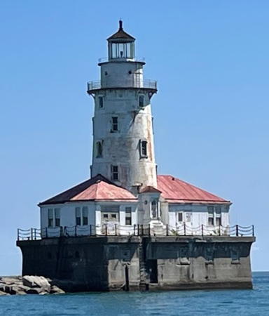
There is no Chicago area lighthouse preservation group and preservation attention has focused almost entirely on the well-known Grosse Pointe Light in Evanston. The historic Chicago Harbor Lighthouse, shown at right, is much in need of restoration..

Aids to navigation in Illinois are maintained by the U.S. Coast Guard Sector Lake Michigan based in Milwaukee, Wisconsin, with an Aids to Navigation Team based at Two Rivers, Wisconsin, but ownership (and sometimes operation) of historic lighthouses has been transferred to local authorities and preservation organizations in most cases.

ARLHS numbers are from the ARLHS World List of Lights. USCG numbers are from volumes 5 and 7 of the U.S. Coast Guard List of Lights.

General Sources
Seeing the Light - The Lighthouses of Illinois
Outstanding historical accounts and photos posted by Terry Pepper.
Illinois Lighthouses
Excellent photos, historical information, and travel directions from Kraig Anderson.
Lighthouse Hunters - Illinois
Photos and accounts by Christine and Tom Cardaci.
Lighthouses in Illinois
Photos by various photographers available from Wikimedia.
Leuchttürme USA auf historischen Postkarten
Historic postcard images posted by Klaus Huelse.
U.S. Coast Guard Navigation Center: Light Lists
The USCG Light List can be downloaded in pdf format.
GPSNautical Charts
Navigation chart for Illinois waters.


Chicago Harbor Light, Chicago, August 2022
Google Maps photo by Kulvir Gill
Lake County (Waukegan Area) Lighthouses
[Waukegan Breakwater (4?)]
Date unknown (station established 1898). Active; focal plane 32 ft (10 m); two white flashes every 5 s. 30 ft (9 m) round cylindrical "D9" tower, painted white with one red horizontal band. Anderson has a photo, a 2021 photo is available, Justin Lessel has a distant street view from the beach, and Google has a satellite view. The National Museum of American History has a historic postcard view of the original lighthouse, a "pagoda" style hexagonal wood tower with lantern and gallery. This lighthouse was rebuilt in 1908 and replaced in 1938, probably by a skeletal tower. Located at the end of the breakwater on the northeast side of Waukegan harbor. Site and tower closed. Owner/site manager: U.S. Coast Guard. USCG 7-20335.
* Waukegan Harbor (2)
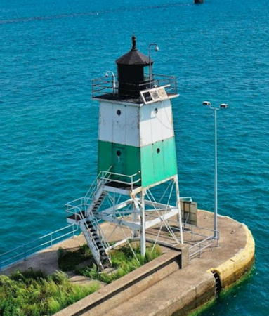
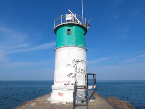
1889. Active; focal plane 36 ft (11 m); green light occulting every 4 s. 35 ft (10.5 m) round cylindrical cast iron tower with gallery, painted white with a broad green band covering the upper third. Fog horn (two 2 s blasts every 30 s) on demand. Michael Alloian's 2023 photo is at right, Pepper has a page for the lighthouse, the Cardacis have a page with photos, Luis Cortes has a 2020 closeup, Greg Krawiec has a 2022 closeup, a closeup street view is available, and Google has a satellite view and a distant street view from the beach. The lighthouse was relocated when the pier was extended in 1905. The lantern and an attached fog signal building were removed after the light station was nearly destroyed by fire in 1967. The Coast Guard has a historic photo showing the lantern, and Pepper also has a Coast Guard photo showing the entire station before the fire. The lighthouse has been a favorite target for graffiti. In 2019 the Army Corps of Engineers completed a renovation of the lighthouse pier; it is now wheelchair accessible. Located at the end of Government Pier at the foot of Madison Street in downtown Waukegan. Accessible by walking the pier. Site open, tower closed. Owner/site manager: U.S. Coast Guard. . ARLHS USA-875; USCG 7-20315.


Waukegan Harbor Light, Waukegan, June 2023
Google Maps photo by Michael Alloian
 

Cook County (Chicago Area) Lighthouses
**** Grosse Point
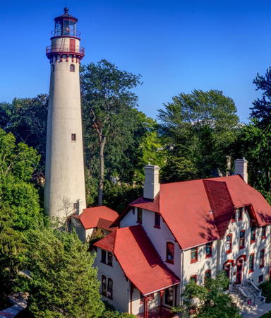
1873 (O.M. Poe). Reactivated (inactive 1941-1946, now maintained by the Lighthouse Park District of Evanston; focal plane 119 ft (36 m); 2 white flashes every 15 s. 113 ft (34 m) round brick tower encased in concrete, with lantern and gallery, connected by a covered walkway to a 3-story brick keeper's house. Lighthouse painted white, lantern and gallery red. The original 2nd order H. LePaute Fresnel lens (1850) is still in service (this is the only 2nd order lens still in use on the Great Lakes). Two fog signal buildings. A 2021 photo is at right, Tom Gill has a photo, Pepper's page has historical information and outstanding photos, Anderson also has a fine page with good photos, Huelse has a historic postcard view, the Coast Guard has a 1914 photo, and Google has a street view and a satellite view. This famous lighthouse was recognized as a National Historic Landmark in 1999. The keeper's house includes a small maritime museum; the fog signal buildings are used for environmental education and summer day camps. Congress leased the light station to the City of Evanston in 1935 when the station was automated and Evanston employed the Lighthouse Park District to care for the original 1873 structure. In 1941 the light was deactivated in favor of offshore buoys. In 1946 the Coast Guard reactivated the light and in 1994 the park district restored the keeper's house to its original appearance and configuration. One half of the duplex keeper’s quarters houses the museum and a park office and the other half is occupied by the park district director who also has the title of keeper. Restoration of the structure is ongoing. Located in Lighthouse Park on Sheridan Road at the foot of Central Street in Evanston. Site open year round, museum and tower open to guided tours Saturday and Sunday afternoons June through September excluding the week of July 4 and the Labor Day holiday weekend in September. Owner: City of Evanston. Site manager: Lighthouse Park District . ARLHS USA-359; USCG 7-20190.
* Farwell Avenue Breakwater (Loyola Beach)
Date unknown. Active (maintained by the city); focal plane 12.5 m (41 ft); red flash every 3 s. 36 ft (11 m) square skeletal tower. Gaurav Kumar has a 2021 photo, Tim Miles has a January 2018 drone view, Manoj Tailor has a photo, Artiom Necrasov has a street view, and Google has a satellite view. Located at the end of a groin at the foot of Farwell Avenue. Accessible by walking the pier. Site open, tower closed. Owner/operator/site manager: City of Chicago. USCG 7-20165.
* Hollywood Avenue Breakwater (Hollywood Beach)
Date unknown. Active (maintained by the city); focal plane 41 ft (12.5 m); red flash every 3 s. 36 ft (11 m) square skeletal tower, painted red. William Rosen has a closeup photo, a 2023 photo is available, J. Kyle White-Sullivan has a closeup street view, and Google has a satellite view. Located at the end of a groin at the north end of Lakeshore Drive, adjacent to Kathy Osterman Beach. Accessible by walking the pier. Site open, tower closed. Owner/operator/site manager: City of Chicago. USCG 7-20145.

Grosse Pointe Light, Evanston, August 2021
Instagram photo by 606_vision
* Foster Avenue Breakwater (Foster Beach)
Date unknown. Active (maintained by the city); focal plane 41 ft (12.5 m); white flash every 3 s. 36 ft (11 m) square skeletal tower, painted red. Sean Farnum has a photo, Tim Salmonson has a 2018 photo, Joseph Peltier has a 2014 street view, and Google has a satellite view. Located at the end of a groin at the Foster Avenue Beach. Accessible by walking the pier. Site open, tower closed. Owner/operator/site manager: City of Chicago. USCG 7-20140.
Wilson Avenue Crib
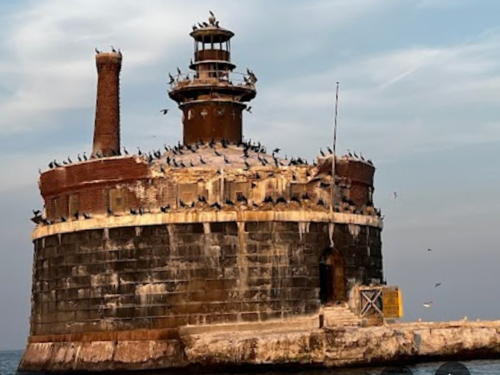
1918. Active (maintained by the city); focal plane 68 ft (21 m); quick-flashing white light. 47 ft (14 m) round cylindrical tower with lantern and gallery; the light is displayed from a platform built atop the lantern room. Fog horn (2 s blast every 20 s). A photo by Mike Zhang is at right, GLLKA's blog has an article on this light, Jeremy Okonski has a closeup photo, the Cardacis have a page with photos, and Bing has a satellite view. The crib is the northernmost of several water intake structures off the lakefront. The structure is in poor condition. Located in the lake about 3 miles (5 km) off Montrose Harbor, on the North Chicago waterfront. Accessible only by boat. Site and tower closed. Owner/operator/site manager: Chicago Department of Water Management. . ARLHS USA-1134; USCG 7-20135.
* Wilson Avenue Breakwater (Montrose Harbor Breakwater, Montrose Point)
Date unknown (maintained by the city). Active; focal plane 41 ft (12.5 m); green flash every 3 s. 39 ft (12 m) square skeletal tower painted red. Jason Mlady has a photo, Jay James has a 2021 drone view, Sawyer Knibbe has a street view, and Google has a satellite view. Located on a curving groin protecting Montrose Harbor, a marina at the foot of Montrose Avenue. Accessible by walking the pier. Site open, tower closed. Owner/operator/site manager: City of Chicago. USCG 7-20130.
* Montrose Harbor East Breakwater (2)
Date unknown. Active (maintained by the city); focal plane 40 ft (12 m); red flash every 3 s. 39 ft (12 m) round tower painted white with two red horizontal bands and mounted on a square concrete base. A 2021 photo is available, Angel Pineda has a photo of both breakwater lights, and Google has a satellite view. USCG lists a skeletal tower. Located on the east breakwater of the Montrose Harbor marina. Accessible by walking the pier. Site open, tower closed. Owner/operator/site manager: City of Chicago (Montrose Harbor). USCG 7-20110.

Wilson Avenue Crib Light, Chicago, June 2023
Google Maps photo by SMake Zhang
* Montrose Harbor West Breakwater (2)
Date unknown. Active (maintained by the city); focal plane 40 ft (12 m); green flash every 3 s. 39 ft (12 m) round tower painted white with two green horizontal bands and mounted on a square concrete base. Willy J. Fraase has a photo, Angel Pineda has a photo of both breakwater lights, Dan Bilthouse has a street view from the west breakwater light, and Google has a satellite view. USCG lists a skeletal tower. Located on the west breakwater of the Montrose Harbor marina. Accessible by walking the pier. Site open, tower closed. Owner/operator/site manager: City of Chicago (Montrose Harbor). USCG 7-20115.
* Belmont Harbor Inner
Date unknown. Active (maintained by the city); focal plane 80 ft (24.5 m); red flash every 3 s. 72 ft (22 m) triangular skeletal tower with gallery mounted on a square 1-story equipment concrete shelter. Nikola Jordanov has a closeup street view, a distant view is available, and Google has a street view and a satellite view. Located on the north side of the entrance to Belmont Harbor, a marina at the foot of Belmont Avenue. Site open, tower closed. Owner/operator/site manager: City of Chicago (Belmont Harbor) .USCG 7-20095.
* North Avenue Jetty (North Avenue Beach, Photography Point)
Date unknown. Active (maintained by the city); focal plane 39 ft (12 m); quick-flashing red light. 33 ft (10 m) square skeletal tower, painted white with a red band at the top. René Molkenthin has a 2017 street view and Google has a street view and a satellite view. Located at the end of a breakwater protecting the North Avenue Beach, at the foot of Lasalle Drive. Accessible by walking the pier. Site open, tower closed. Owner/operator/site manager: City of Chicago. USCG 7-20055.
William E. Dever Crib
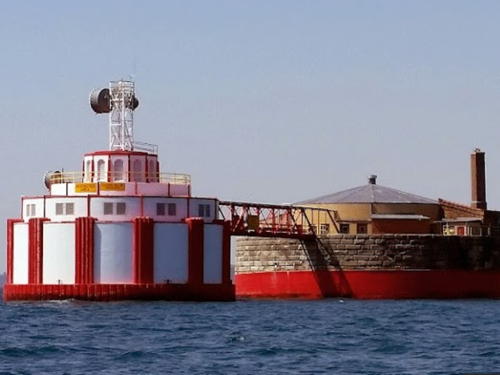
1935. Active (maintained by the city); focal plane 72 ft (22 m); quick-flashing white light. Fog horn (2 s blast every 20 s). Square cylindrical white skeletal tower centered atop a large, circular water intake structure. A 2024 photo is seen at right, Jack Fleming has a 2016 drone view, David Gleason has a photo, Pepper has a fine page for the lighthouse, the Cardacis have a page with photos, Donald Carter has a good photo, Kirk Kessler has a 2007 photo, and Bing has a satellite view. The NOAA Great Lakes Environmental Reseach Laboratory maintains a weather station on the crib; a NOAA webcam shows the Chicago skyline. This light replaced a light established in 1900 on the adjacent Carter Harrison Crib. (The Dever Crib was built to replace the Harrison Crib, but because of increased water demand the Harrison Crib remained in use until 1997.) Located in the Lake about 3 miles (5 km) off the Chicago River entrance. Accessible only by boat. Site and tower closed. Owner/operator/site manager: Chicago Department of Water Management. ARLHS USA-1248; USCG 7-20040.

William E. Dever Crib Light, Chicago, October 2024
Google Maps photo by Carsten
Chicago Harbor
1893 (relocated to the end of the breakwater in 1918). Active; focal plane 82 ft (25 m); red flash every 5 s. 48 ft (14.5 m) round cast iron tower with lantern and gallery, sandwiched between two 1-story buildings (a fog signal building and a boathouse). Lighthouse painted white, lantern roof black; the building roofs are red. The original 3rd order Fresnel lens, exhibited at the Chicago World's Fair of 1893, is now at the Old Point Loma Lighthouse in San Diego, California. Keeper's quarters incorporated in the tower. Kulvir Gill's 2022 photo is at the top of this page, Pat and Ellen Prather have a good 2009 photo, a fine 2007 photo is available, Pepper has a page for the lighthouse, Girish Barve has a 2023 photo, Marinas.com has aerial photos, and Google has a lake view and a satellite view. A unique lighthouse: its design is similar to that of the offshore sparkplug towers, but this tower is taller. An excellent history of the lighthouse is available. The lighthouse was originally built on a crib just inside the original end of the breakwater. It was relocated after the breakwater was extended, and the present fog signal building and boathouse were added during relocation. Gravely endangered. The tower was restored by the Coast Guard in 1997. In 2005 the lighthouse became available for transfer under NHLPA. The City of Chicago applied for ownership and after an unusually long period of consideration the Interior Department approved that application in February 2009. Since then the city has done nothing to restore the lighthouse, although several entrepeneurs expressed interest in possible uses for the building. In 2020 negotiations were underway to return ownership to the federal government. Kulvir Gill's 2022 photo shows the steady deterioration of the lighthouse under the city's lack of attention. On a more positive note the Friends of the Chicago Harbor Lighthouse has formed to work for preservation of the lighthouse. Located at the south end of the north harbor breakwater, about 1 km (0.6 mi) east of the Southeast Guidewall Light. Accessible only by boat. There are good views from the Navy Pier or from harbor sightseeing cruises; the lighthouse can be seen distantly from many places on the Chicago lakefront. Site and tower closed. Operator: U.S. Coast Guard. Owner/site manager: City of Chicago. . ARLHS USA-171; USCG 7-19960.
Chicago Harbor Southeast Guidewall
1912 (installed here in 1938). Active; focal plane 48 ft (14.5 m); white light, 3 s on, 3 s off. 30 ft (9 m) square pyramidal skeletal tower with upper half enclosed, lantern and gallery. Lighthouse painted white with a single green horizontal band; lantern painted black. R.J. Rauen's 2021 photo is at right, Wikimedia has Frank Buchalski's photo, Fernando Momberg has a 2020 photo, and Google has a lake view and a satellite view. This light marks the entrance to the Chicago River and an inland waterway leading to the Mississippi River. The lighthouse was built in 1912 as the Kewaunee Pierhead Light in Northeastern Wisconsin. It was replaced in Kewaunee in 1931, stored at the Milwaukee lighthouse depot, and then installed in Chicago in 1938. It is sometimes described incorrectly as the Navy Pier Lighthouse. Located on a guidewall on the south side of the river entrance, south of Navy Pier in Chicago. There are good views from the south side of Navy Pier. Site and tower closed. Owner/operator/site manager: U.S. Coast Guard. ARLHS USA-930; USCG 7-20000.

Southeast Guidewall Light, Chicago, August 2021
Google Maps photo by R.J. Rauen
Four Mile Crib
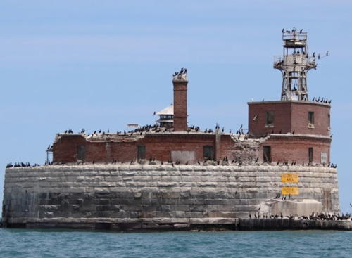
1898. Active (maintained by the city); focal plane 66 ft (20 m); white flash every 15 s. Approx. 30 ft (9 m) hexagonal skeletal tower with lantern and gallery, painted red. Todd Furr's 2021 photo is at the bottom of this page, Michael Moss has a 2017 closeup photo, the Cardacis have a page with photos, and Mike McGhie contributed a 2003 photo, but the crib is only a fuzzy blob in Google's satellite view. Visible distantly from Navy Pier. A 2023 drone view shows that the structure is in poor condition. Accessible only by boat. Site and tower closed. Owner/operator/site manager: Chicago Department of Water Management. . ARLHS USA-304; USCG 7-19925.
68th Street Crib (Dunne Crib)
1909. Active (maintained by the city); focal plane 61 ft (20 m); red flash every 3 s. 50 ft (15 m) hexagonal skeletal tower lantern and gallery. Lighthouse painted red (formerly painted blue); lantern roof is silver-gray. Shawn Lawrence's photo is at right, Pepper also has a fine page for this lighthouse, the Cardacis have a page with photos, Google has a very distant street view from Jackson Park, and Bing has a satellite view. The crib was the main water intake for South Chicago for many years. On January 20, 1909, while it was under construction, it was the scene of a disastrous fire that claimed the lives of 60 workers. Visible distantly from the lakeshore in the Jackson Park-South Shore area. Accessible only by boat. Site and tower closed. Owner/operator/site manager: Chicago Department of Water Management. ARLHS USA-1090; USCG 7-19870.

68th Street (Dunne) Crib Light, Chicago, July 2021
Instagram photo by Shawn Lawrence

Illinois Waterway Lighthouses
The Illinois Waterway connects Lake Michigan to the Mississippi River via the Calumet and Illinois Rivers. The waterway is 336 mi (541 km) in length and is maintained by the U.S. Army Corps of Engineers; navigational aids are maintained by the U.S. Coast Guard.
Cal-Sag Junction
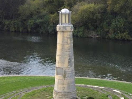
1994. Active (privately maintained); focal plane 47 ft (14 m); continuous amber light. 30 ft (9 m) round unpainted limestone tower with lantern. A 2023 photo is at right, the water authority has a drone view, Jacek Miskowiec has a photo, John Jacob has a view from the waterway, and Google has a satellite view. In the early 1990s the Illinois Waterway System built streamside elevated pool aeration (SEPA) stations that use artifically created waterfalls to improve water quality through aeration. This lighthouse is an attractive feature of SEPA Station 5. Located at the junction of the Chicago Sanitary and Ship Canal and the Cal-Sag Channel northeast of Lemont. Site and tower closed, but there's a good view of the lighthouse from the Illinois and Michigan Canal Trail on the west side of the waterway. Located at river mile 303.5. Owner/site manager: Metropolitan Water Reclamation District of Greater Chicago. USCG 5-5745.
* Seneca (2)
Date unknown. Active (privately maintained); focal plane 27 ft (8 m); two red flashes every 6 s. 19 ft (6 m) hexagonal wood lighthouse, painted white, mounted on a square concrete base. Karen Munster has a 2018 photo, and Shannon Jones also has a photo, but trees shade the lighthouse in Google's satellite view. Located on the south side of the Illinois River in Seneca. Site open, tower closed. Owner/site manager: Anchor In Marina. USCG 5-6325.
[Henry (Longman's Landing)]
1935. Inactive since 1945. 18 ft (5.5 m) round rubblestone tower; the light was shown through a square window at the top. No current photo available and the tiny light is not seen in Google's satellite view. This small light was built by Elsie Longman (famous as "Steamboat Elsie") using stones from the abandoned Henry Lock and Dam. It served as a leading light for southbound vessels passing under the Henry Bridge (IL 18), and it was recognized as an official aid to navigation. It lapsed when Elsie died in 1945. Located on the west bank a short distance south of the bridge. Site status unknown. Owner/site manager: unknown.

Cal-Sag Junction Light, Lemont, October 2023
Google Maps photo by Hazardous Voltage
Chillicothe Island
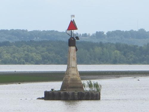
Date unknown. Active; focal plane about 9 m (30 ft); two red flashes every 5 s. 9 m (30 ft) tapered square concrete tower topped by a red triangular daymark and mounted on a round caisson. A photo is at right and Google has a satellite view. Between Chillicothe and Peoria the Illinois River widens into a series of broad basins. This is one of six caisson lights marking the channel through these basins. Located on the east side of the river channel off the southern tip of Chillicothe Island, about 1.5 mi (2.5 km) south of Chillicothe at river mile 179.0. Accessible only by boat. Site open, tower closed. USCG 5-6965.
Rome
Date unknown. Active; focal plane about 9 m (30 ft); two red flashes every 5 s. 9 m (30 ft) tapered square concrete tower topped by a red triangular daymark and mounted on a round caisson. No photo available but Google has a satellite view and a distant street view. Located at river mile 177.4 on the east side of the river channel off the southern part of Rome. Accessible only by boat. Site open, tower closed. USCG 5-6975.
Sand Point
Date unknown. Active; focal plane about 9 m (30 ft); green flash every 4 s. 9 m (30 ft) tapered square concrete tower topped by a green square daymark and mounted on a round caisson. No photo available but Google has a street view and a satellite view. Located at river mile 176.6 on the west side of the river channel 0.8 mi (1.3 km) southwest of the Rome Light. Accessible only by boat. Site open, tower closed. USCG 5-6980.
Detweiler Park (Mossville)
Date unknown. Active; focal plane about 9 m (30 ft); green flash every 4 s. 9 m (30 ft) tapered square concrete tower topped by a green rectangular daymark and mounted on a round caisson. No photo available but Google has a distant street view and Bing has a satellite view. Located at river mile 170.9 on the west side of the river channel off Detweiler Park, on the south side of Mossville. Accessible only by boat. Site open, tower closed. USCG 5-7025.

Chillicothe Island Light, Chillicothe, August 2013
photo by Kevin and Debbie
#Drolls Point (1)
Date unknown. Removed; the light is listed with focal plane about 9 m (30 ft); green flash every 4 s. 9 m (30 ft) tapered square concrete tower topped by a green square daymark and mounted on a round caisson. No photo available. Jon Clay passed this site in 2021 and found that the light had been removed; probably it was replaced with a modern post light. Bing has an indistinct satellite view. Located at river mile 168.9 on the west side of the river channel a short distance north of Peoria Heights. Accessible only by boat. Site open, tower closed. USCG 5-7035.
* IVY Club (Peoria Heights)
Date unknown. Active (privately maintained and unofficial); focal plane 60 ft (18 m); flashing green light. Lantern mounted atop a 3-story yacht club building. A photo is available, Marinas.com has aerial photos of the club, and Google has a good satellite view. Located at river mile 167.8 on the west side of the Illinois River at 5102 North Galena Road in Peoria Heights. Site open, tower closed. Owner/site manager: Illinois Valley Yacht and Canoe Club.
* IVY Club Breakwater
2013. Active (privately maintained and unofficial); focal plane 28 ft (8.5 m); flashing white light. Approx. 20 ft (6 m) octagonal steel tower with lantern mounted on an octagonal concrete base. Upper half of the tower painted red, lower half white, lantern black. A 2022 photo by Kristin Lewis is at right, a 2021 photo and a distant 2016 photo are available, and Google has a satellite view. Located at the end of the extended breakwater of the IVY Club. Site open, tower closed. Owner/site manager: Illinois Valley Yacht and Canoe Club.
Avery
Date unknown. Active; focal plane about 9 m (30 ft); two red flashes every 5 s. 9 m (30 ft) tapered square concrete tower topped by a red square daymark and mounted on a round caisson. No photo available but Google has a very distant street view and Bing has a satellite view. Located at river mile 165.3 on the east side of the river channel off Peoria, about 1/2 mi (800 m) south side of the McClugage (US 24) Bridge. Accessible only by boat. Site open, tower closed. USCG 5-7060.
East Peoria (Eastport Marina) (2?)
2022. Active; focal plane about 17 ft (5 m); green flash every 6 s. Approx. 17 ft (5 m) tower painted white. Neil Larimore has a drone view and Google has a satellite view and an October 2022 street view. This light replaced an earlier light on an outer breakwater of the marina. However Larimore's 2022 drone view shows that the marina's outer breakwaters were removed and replaced by floating barriers. Located at the end of the main breakwater of the Eastport Marina, on the east side of the Illinois River (here pooled as Lake Peoria) at river mile 164.3 in East Peoria. Site status unknown, possibly open; tower closed. Owner/site manager: City of East Peoria. USCG 5-7072.1.
 

IVY Club Breakwater Light, Peoria Heights, June 2022
Google Maps photo by Kristin Lewis

Sangamon County (Lake Springfield) Lighthouse
Michaud (Lake Springfield)
2009. Active (privately maintained and unofficial); focal plane 30 ft (9 m); flashing white light. 30 ft (9 m) octagonal wood tower with lantern and gallery, painted white; the lantern roof is red. A photo and a closeup are available, and Google has a street view and a satellite view. The lighthouse was designed and built by Larry and Loretta Michaud as a replica of the Cheboygan Crib Light (see Michigan Northeastern Lower Peninsula). Located at the tip of sharp peninsula projecting into Lake Springfield just east of the I-55 bridge, on the south side of Springfield. Site and tower closed. Owner/site manager: private.

Massac County (Ohio River) Lighthouse
* Metropolis Hope
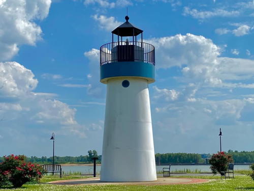
2014. Active (privately maintained and unofficial; charted by C-Map as a landmark); focal plane about 40 ft (12 m); flashing white light. 30 ft (9 m) round steel tower with lantern and gallery. Lighthouse painted white with a blue band at the top; the lantern is black. A 2021 photo is at right, Dave Cantrell has a photo, Kevin Thompson has a 2021 photo, Stephen Francia has a 2022 photo, Jeremy D'Entremont contributed a 2015 photo, and Google has a satellite view, but the tower is too new to appear in Google's 2013 street view of the location. The lighthouse was built by the Hope Light Project, a charity dedicated to the fight against cancer. Prefabricated by the Parker Custom Machine Shop in Metropolis, the lighthouse was installed and activated in June 2014. In 2022 the lighthouse was repainted and new lighting was installed. Located in Dorothy Miller Park at Metropolis; parking provided at the lighthouse. Site open, tower closed. Operator/site manager: Hope Light Foundation. .

Hope Light, Metropolis, May 2021
Instagram photo by koolkat99xo

Mississippi River Lighthouses
* [Cairo Point]
Date unknown. Active; focal plane about 30 ft (9 m); three red flashes, in a 2+1 pattern, every 6 s. Approx. 4.5 m (15 ft) skeletal mast carrying a diamond-shaped daymark painted in a red and white checkerboard pattern. Jim Frazier has a photo, Kevin Sheahan has a street view, and Google has a satellite view. No one would call this modest beacon a lighthouse, but it marks a crucial spot: the confluence of the Ohio and Mississippi Rivers. Located at the end of Fort Defiance Road off US 60/62 in Cairo. Site open. Owner: U.S. Coast Guard. Site manager: Illinois State Parks (Fort Defiance State Park). USCG 5-17670.
St. Louis Water Intake #2
1915. Inactive. Approx. 60 ft (18 mi) 3-story stone water intake tower mounted on a concrete pier. The tower is unpainted. David Ortega's 2024 photo is at right, Wikimedia has David Hinkson's photo, Erin and Lance Willett have a good photo, the City of St. Louis has a page with a photo, Robert Anton has a street view, and Google has a satellite view. This is the younger of two historic water intake towers; the older (1894) tower is across the state line in Missouri. The towers are built in the rapids of the Mississippi River, known as the Chain of Rocks. Since 1953 the rapids have been bypassed by the Chain of Rocks Lock and Canal. However, during the late 1800s and early 1900s the navigation channel passed between the two intake towers, so both were lit; for many years they were also staffed. Located about 1000 ft (300 m) off the east bank of the river and 250 ft (80 m) south of the old Chain of Rocks Bridge, which has been renovated for use by walkers and bicyclists. Accessible only by boat; there is an excellent view from the old bridge. Site open, tower closed.

St. Louis Water Intake #2, Granite City, September 2024
Google Maps photo by David Ortega
* Grafton
2007. Active (unofficial but charted as a daybeacon); continuous white light. 40 ft (12 m) round tower with lantern and gallery rising from a square 1-story stone building. Ron White has a photo, another photo (second photo on the page) is available, and Google has a street view and a satellite view. The lighthouse symbolizes the village's resurrection after being devastated by a 1993 flood. Located on the waterfront at Grafton, where it marks the confluence of the Illnois and Mississippi Rivers. Site open, tower closed. There's also a good view from the ferry between Grafton and St. Charles, Missouri. Owner/site manager: City of Grafton. .
* Quinsippi (2)
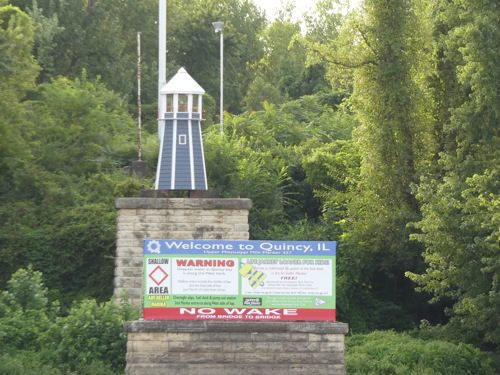
2017 (station established around 1972). Active; white light. Approx. 25 ft (7.5 m) hexagonal tower with lantern mounted atop a stone base (a former bridge pier). Lighthouse painted blue with white trim, lantern white. A photo by Andreas Schuldt is at right and Google has a satellite view. Quinsippi Island, on the east side of the river just above downtown Quincy, shelters a small boat channel that leads to several marinas. The original light was donated by the Moorman Manufacturing Company, which had built it for a promotion. Google has a 2012 street view of the first lighthouse. The light failed in late 2011 but the park district repaired it in 2012. In July 2015 a windstorm blew the lighthouse off its stone base and the park district had no funds to restore it. As a result the lighthouse is missing in Google's August 2016 street view. In 2016 the Quincy Boat Club raised $5000 to replace the lighthouse and the new lighthouse was installed in the summer of 2017. Located at the end of Quinsippi Island Road on the east side of the island near its southern tip. Site open, tower closed. Owner/site manager: Quincy Park District.

Quinsippi Light, Quincy, August 2017
photo copyright Andreas Schuldt; used by permission

Notable faux lighthouses:

Information available on lost lighthouses:

  • Calumet Harbor (1) (1853-55; reactivated ca. 1873-76). Lighthouse Digest has a November 2015 article with a historic photo. The modern light is across the state line in Indiana.
  • Carter Harrison Crib (1900-1935), Chicago (see above under William E. Dever Crib). ARLHS USA-1197.
  • Chicago (1831-1860), at Fort Dearborn. The first lighthouse (1831) collapsed and was replaced by a conical stone tower the following year. Wikimedia has an 1838 drawing. ARLHS USA-170.
  • Chicago North Pier (1859-1893). This lighthouse was disassembled and used in the construction of the Rawley Point lighthouse in Southeastern Wisconsin. ARLHS USA-172.
  • Chicago North Pierhead Range Front (1906?-1930s). The fate of this lighthouse is not known.
  • Little Fort (1849-1899), Waukegan. Nothing remains of this lighthouse; it was replaced by the Waukegan Harbor Light (see above). Anderson also discusses this light on his Waukegan Harbor page.
  • Port Clinton (1856-1860), Port Clinton, north of Chicago. Pepper has a historic photo. Nothing remains of this lighthouse.
  • Taylorsport (1858-59), Taylorsport. Almost nothing is known about this long-vanished lighthouse.
  • Twelfth Street Crib (?-?), Chicago. No information about this light is available.
  • Two-Mile Crib (1865-1900), Chicago. This crib was replaced by the Carter Harrison Crib (see above under William E. Dever Crib). Anderson has images of the 1866 lighthouse and a second lighthouse in 1910.

Four Mile Crib Light, Lake Michigan, July 2021
Google Maps photo by Todd Furr

Adjoining pages: North: Southeastern Wisconsin | East: Indiana

Return to the Lighthouse Directory index

Checked and revised December 16, 2024. Lighthouses: 33. Site copyright 2024 Russ Rowlett and the University of North Carolina at Chapel Hill.