Lighthouses of India: Odisha

The Republic of India (Bhārat in Hindi) is the seventh largest country and most populous country in the world. It occupies a subcontinent of Asia that projects southward into the North Indian Ocean, separating the Bay of Bengal on the east from the Arabian Sea on the west. Before 1947 it was a patchwork of regions governed as British colonies and semi-independent princely states under British supervision. In 1947 this British Raj was partitioned into the independent states of India and Pakistan. Several French and Portuguese colonies embedded in the territory of India were absorbed in 1950 and 1961, respectively.

India is a federal union comprising 28 states and 8 union territories. This page lists lighthouses of the state of Odisha (formerly Orissa) on India's northeast coast. Its coastline faces the head of the Bay of Bengal and is almost everywhere low and sandy, with numerous offshore shoals. Paradeep is Odisha largest port.

India's lighthouse heritage is British. However, only a fraction of the original British lighthouses remain in use; new towers have been built at most of the stations. India has also built many lighthouses at new locations in recent years. Nearly all of the larger Indian lighthouses are staffed and by long tradition the staff will receive visitors at a specific time, usually late in the afternoon. Several lighthouses have been developed as tourist attractions and have longer hours.

Hindi and English are official languages in India, with English serving as a lingua franca for the entire nation. The Indian Constitution recognizes another 21 languages, called scheduled languages, and each of the coastal states has its own scheduled language in official use. In Bengali, the official language of West Bengal, the word for a lighthouse is bātighara (বাতিঘর); dbīpa or dwip is an island, nadī is a river, and bandara is a port or harbor. In Odia, the official language of Odisha, the English word "lighthouse" is transliterated as linhathausē (ଲିଂହଥୌସେ).

Lighthouses and aids to navigation in India are administered by the Directorate General of Lighthouses and Lightships (DGLL), an agency of the Ministry of Shipping. Lighthouses of West Bengal and Odisha are maintained by the Kolkata Directorate of DGLL.

ARLHS numbers are from the ARLHS World List of Lights. Admiralty numbers are from volume F of the Admiralty List of Lights & Fog Signals. U.S. NGA List numbers are from Publication 112.

General Sources
Aids to Navigation - Kolkata Region
Lighthouse information from DGLL, including photos for most of the lighthouses.
World of Lighthouses - India
Photos by various photographers available from Lightphotos.net.
Lighthouses in India - Odisha
Photos by various photographers available from Wikimedia.
Online List of Lights - India - Bay of Bengal
Photos by various photographers posted by Alexander Trabas.
World Lights - India
Historic postcard images posted by Michel Forand.
Leuchttürme Asiens auf historischen Postkarten
Historic postcard images posted by Klaus Huelse.
Google Maps
Satellite view of the Odisha coast.


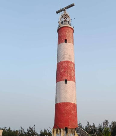
Chandrabhaga Light, Puri District, Odisha, February 2023
Google Maps photo by Chandra Shekhar Satti
Kendrapara District Lighthouse
** False Point (Batighar)
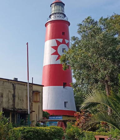
1836. Active; focal plane 38 m (125 ft); two white flashes every 20 s. 38 m (125 ft) round granite tower, painted with horizontal red and white bands. The lighthouse traditionally carries a 10-point star-shaped daymark, placed in recent years on one of the white bands. Somanath Debnath's 2022 photo is at right, Pravir Sahoo has a 2015 photo, Smrutirekha Dey has a photo, Alok Swain has a street view, and Google has a satellite view. The lighthouse was built to mark the entrance to the Mahanadi River; it also marks the nearby cape, which is called False Point because mariners bound for Calcutta sometimes mistook it for Palmyras Point farther north. This is one of three lighthouses in Odisha designated for tourist development in 2011 but lack of easy land access has these plans on hold. Located about 2.5 km (1.5 mi) from the coastline and south of the point, about 30 km 19 mi) northeast of Paradip (Paradeep). Site open, tower open late afternoons daily. . ARLHS IND-033; Admiralty F1006; NGA 26900.

Jagatsinghpur District (Port of Paradeep) Lighthouses
The port of Paradeep (Paradip), Odisha's only deepwater port, is an artificial harbor constructed in 1962-66. The area surrounding the port has been developed as an industrial center. The Admiralty uses the spelling Paradip but DGLL lists the main lighthouse as Paradeep and that spelling prevails locally.

Paradip North Breakwater (2?)
Date unknown. Active; focal plane about 12 m (39 ft); green flash every 5 s. 8 m (26 ft) round barbell-shaped tower colored with green and white horizontal bands. Jitendra Dash has a distant view and Google has a satellite view. Located at the end of the north breakwater of the harbor entrance. Site and tower closed. Admiralty F1005.4; NGA 26912.
Paradip Entrance Range Front (3 towers)
Date unknown. Active; focal plane 28 m (92 ft); white light, 1 s on, 1 s off. Approx. 18 m (59 ft) tower carrying a daymark painted with black and white horizontal bands and flanked by similar towers defining the two sides of the channel. Asish Behera has a photo of the central tower, Manoj Dayak also has a photo, and Google has a satellite view. Google also has satellite views of the starboard and port front lights. Located on the west side of the harbor entrance. Site status unknown. Admiralty F1005.6, F1005.612 (starboard), F1005.614 (port); NGA 26916.

False Point Light, Batighar, July 2022
Google Maps photo by Somanath Debnath
Paradip Entrance Range Middle
Date unknown. Active; focal plane 45 m (148 ft); white light, 2 s on, 3 s off. Approx. 40 m (131 ft) square pyramidal skeletal tower carrying a rectangular slatted daymark painted with black and white horizontal bands. Google has a street view and a satellite view. Located 1650 m (1.026 mi) northwest of the front light. Site status unknown. Admiralty F1005.605; NGA 26918.
Paradip Entrance Range Rear (3 towers)
Date unknown. Active; focal plane 60 m (197 ft); white light, 5 s on, 5 s off. Approx. 40 m (131 ft) square pyramidal skeletal tower topped by a skeletal mast carrying a rectangular slatted daymark painted with black and white horizontal bands flanked by similar towers defining the two sides of the channel. Google has a street view and a satellite view. Google also has satellite views of the starboard and port rear lights. Located 740 m (0.46 mi) northwest of the front light. Site status unknown. Admiralty F1005.61, F1005.6121 (starboard), F1005.6141 (port); NGA 26920.
Paradip Inner Harbor Range Front (2) (3 towers)
Date unknown. Active; focal plane 28 m (92 ft); quick-flashing white light. Approx. 25 m (82 ft) round tower carrying a daymark painted with black and white horizontal bands and flanked by towers defining the two sides of the channel. No photo available but Google has a satellite view. Google also has satellite views of the starboard and port front lights. Located on the west side of the harbor. Site status unknown. Admiralty F1005.8, F1005.811 (starboard), F1005.813 (port); GA 26924.
Paradip Inner Harbor Range Rear (3 towers)
Date unknown. Active; focal plane 33 m (108 ft); white flash every 4 s. Approx. 30 m (98 ft) tower carrying a daymark painted with black and white horizontal bands. No photo available but Google has a satellite view. Google also has satellite views of the starboard and port rear lights. Located on the west side of the harbor, 300 m (980 ft) northwest of the front light. Site status unknown. Admiralty F1005.81, F1005.812 (starboard), F1005.814 (port); NGA 26928.
Paradip Customs Office
Date unknown. Active; focal plane 15 m (49 ft); nine red flashes every 15 s. 14 m (46 ft) mast atop a building. No photo available and the light is inconspicuous in Google's satellite view. Located on the west side of the harbor. Site status unknown. Admiralty F1005.92; NGA 26936.
Paradip Port Control
Date unknown. Active; focal plane 15 m (49 ft) (?); green flash every 2 s. Light mounted on a mast on a 5-story port control building. Deepak Kumar has a 2018 closeup photo, Santhosh Mosa has a distant photo, Muhammad Raheem has a 2021 view from the harbor, and Google has a satellite view. The listed focal plane is much too low. Located on the west side of the harbor. Site status unknown. Admiralty F1005.9; NGA 26932.
*** Paradip (Paradeep)
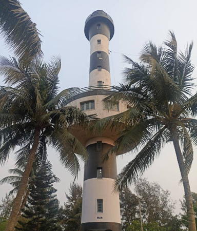
1988. Active; focal plane 40 m (131 ft); three white flashes every 30 s. 40 m (131 ft) round concrete tower with lantern, gallery, and a circular observation and control room about 1/3 the way up the tower. Lighthouse painted with black and white horizontal bands; lantern dome painted red. Rudra Pratap Majhi's 2024 photo is at right, Jitendra Dash has a similar 2022 closeup, Sujit Kumar Mishra has a 2019 photo, Linga Raju has a 2017 photo, Jitendra Dash has a 2022 closeup, Sitansu Sekhar Sutar has a street view, and Google has a satellite view. In 2013 the lighthouse was identified as one of three Odisha light stations scheduled for development as tourist attractions. Located behind the beach about 10 km (6 mi) southwest of downtown Paradip. Site open, tower open daily. . ARLHS IND-049; Admiralty F1004.4; NGA 26937.

Paradip Light, Paradeep, March 2024
Google Maps photo by Rudra Pratap Majhi

Puri District Lighthouses
** Chandrabhaga
1968. Active; focal plane 37 m (122 ft); white flash every 10 s. 30 m (98 ft) round masonry tower, painted with horizontal red and white bands. Two 1-story keeper's houses. Chandra Shekhar Satti's 2023 photo is at the top of this page, Sangeeta Kumari has a closeup 2011 photo, Subhajit Mishra has a 2016 photo, and Google has a satellite view. This is one three lighthouses in Odisha designated for tourist development in 2011. Located just off the beach near Konarak (Konark). Site open, tower open late afternoons daily. . ARLHS IND-025; Admiralty F1003; NGA 26940.
*** Puri (4)
2002 (station established 1887). Active; focal plane 29 m (95 ft); three white flashes every 20 s. 25 m (82 ft) round cylindrical concrete tower with lantern and double gallery, painted with horizontal black and white bands. Several 1-story keeper's cottages nearby. Amit Dey's 2024 photo is at right, Suprriya Basak has a 2022 photo, Aditya Biswaman has a 2017 closeup, Tamal Guha has a late evening street view from the beach, and Google has a satellite view. This is by far the best known lighthouse of Odisha. Early lights were mounted on the wall of the Circuit House; in 1956 a skeletal tower was mounted atop a new Circuit House. The Puri area is a very popular seaside resort; H.G. Mukhopadhyay has a photo of the lighthouse standing among the beachfront buildings. Located just off the beach to the southwest of Puri. Site open, tower open 4 pm to 5 pm daily. . ARLHS IND-056; Admiralty F1002; NGA 26944.

Ganjam District Lighthouses
Prayagi (Pryagi, Proyagi)
2012. Active; focal plane 40 m (131 ft); two white flashes every 10 s. 32 m (105 ft) round concrete tower with lantern and gallery, painted with red and white spiral bands. Susanta Patra has a closeup 2020 photo, a 2023 photo is available, Manoj Pradhan has a 2017 photo, and Google has a satellite view. Located on the coast about 25 km (15 mi) northeast of Ganjam. Site open, tower status unknown. Admiralty F1000; NGA 26946.
Gopalpur Range Front
2018. Active; focal plane 12 m (39 ft); quick white flash every 0.5 s. 12 m (39 ft) skeletal tower. A photo is available, the tower is at lower right in a photo of the port, the range lights are at the far right in a view from the harbor, and Google has a fuzzy satellite view. Located at a new port developed by Penna Cement Industries about 8 km (5 mi) northeast of Gopalpur. Site status unknown. Admiralty F0988.1.

Puri Light, Puri, February 2024
Google Maps photo by Amit Dey
Gopalpur Range Rear
2018. Active; focal plane 21 m (69 ft); quick white flash every 2 s. 21 m (69 ft) skeletal tower. The range lights are at the far right in a view from the harbor, and Google has a satellite view. Located about 400 m (1/4 mi) west of the front light. Site status unknown. Admiralty F0988.2.
*** Gopalpur (4)
1967 (station established 1871). Active; focal plane 48 m (148 ft); white flash every 5 s. 32 m (105 ft) round masonry tower with lantern and gallery, attached to several 1-story keeper's houses. Lighthouse painted with horizontal red and white bands. Narasingh Naik's 2022 photo is at right, a good closeup photo is available, Purnima Roy has a more distant view, Umashankar Behera has a street view from the beach, and Google has a satellite view. The original mast light was replaced by a skeletal tower in 1925; a second skeletal tower was built in 1948. Gopalpur-on-Sea is also a very popular seaside resort, and this is one of the three lighthouses in Odisha designated for tourist development in 2011. Located just off the beach at Gopalpur-on-Sea, about 15 km (9 mi) southeast of Brahmapur in southern Odisha. Site open, tower open 3:30 pm to 5:30 pm daily. . ARLHS IND-035; Admiralty F0988; NGA 26948.

Information available on lost lighthouses:

Notable faux lighthouses:


Gopalpur Light, Gopalpur-on-Sea, November 2022
Google Maps photo by Narasingh Naik

Adjoining pages: East: West Bengal | South: Andhra Pradesh

Return to the Lighthouse Directory index | Ratings key

Posted January 20, 2006. Checked and revised July 4, 2024. Lighthouses: 24. Site copyright 2024 Russ Rowlett and the University of North Carolina at Chapel Hil