Lighthouses of Italy: Liguria

Most of Italy (officially the Italian Republic, Repubblica Italiana in Italian) occupies a long peninsula in the Mediterranean Sea, with the Adriatic and Ionian Seas on the east and the Ligurian and Tyrrhenian Seas to the west; the country also includes the Mediterranean's two largest islands, Sicily and Sardinia, and many smaller islands. With this geography Italy has a very long coastline reckoned by geographers at about 7600 km (4722 mi). Guarding this coast are many lighthouses; the Directory lists more than 400.

Italy is divided into 20 regions (regioni), many of them well known outside the country in their own right; the regions are subdivided into provinces. The region of Liguria is located in the northwestern corner of the country facing the Ligurian Sea, the arm of the Mediterranean between Corsica and the mainland of Europe. The major Ligurian port is Genova (Genoa) and historically that city controlled this region. Imperia, Savona and La Spezia are additional ports in Liguria.

The Repubic of Genoa was a maritime power from around 1100 until 1797, when it fell under the control of Napolean. Following the Napoleonic wars in 1815 it became part of the Kingdom of Sardinia until the unification of Italy in 1860. The scenic Ligurian coastline is famous today as the Italian Riviera.

The Italian word for a lighthouse is faro, plural fari. This name is usually reserved for the larger coastal lights; smaller beacons are called fanali. In Italian isola is an island, isolotto is an islet, secca is a shoal, cabo is a cape, punta is a point of land, baia is a bay, stretto is a strait, fiume is a river, and porto is a harbor.

Aids to navigation in Italy are operated and maintained by the Italian Navy's Servizio dei Fari e del Segnalamento Marittimo (Lighthouse and Maritime Signal Service). Lighthouse properties are naval reservations, generally fenced and closed to the public.

ARLHS numbers are from the ARLHS World List of Lights. EF numbers are from the Italian Navy's light list, Elenco Fari. Admiralty numbers are from volume E of the Admiralty List of Lights & Fog Signals. U.S. NGA List numbers are from Publication 113.

General Sources
Fari e Segnalamenti
Lighthouse information from the Italian Navy's Servizio dei Fari.
Online List of Lights - Italy
Photos by verious photographers posted by Alexander Trabas. Some of the photos for this area are by Capt. Peter Mosselberger ("Capt. Peter") or by Egidio Ferrighi.
Leuchttürme in Italien
Photos by Andreas Köhler.
Cyberlights Lighthouses - Italy
Photos of Italian lighthouses by Egidio Ferrighi, posted by Gary Richardson and Anna Klein.
Italy Lighthouses
Aerial photos posted by Marinas.com.
Wikimedia: Lighthouses in Italy
Photos by verious photographers available in Wikimedia Commons.
World of Lighthouses - Italy
Photos by verious photographers available from Lightphotos.net.
Italienische Leuchttürme auf Historischen Postkarten
Historic postcard images posted by Klaus Huelse.
GPSNauticalCharts
Navigation chart for the Ligurian Sea.
Navionics Charts
Navigational chart for Liguria.


Lanterna di Genova, Genoa, August 2021
Instagram photo
by Holm Pajung

La Spezia Province Lighthouses
La Spezia is the second largest city of Liguria, after Genova. An important port and a major base for the Italian Navy, it has a population of about 100,000.
* Punta Santa Teresa
Date unknown. Active; focal plane 10 m (33 ft); two green flashes every 6 s. 5 m (17 ft) round cylindrical tower with lantern and gallery, painted green and mounted on a stone mole. Ferrighi has a photo, Trabas has Capt. Peter's photo, Wikimedia has Massimiliano Galardi's closeup, Mario Parodi has a 2020 photo, Maria Rita Manzoni has a street view, and Google has a satellite view. Located on the point 800 m (1/2 mi) south of Muggiano, opposite the end of the outer breakwater of La Spezia. Site open, tower closed. ARLHS ITA-252; EF-1745; Admiralty E1274; NGA 7820.
La Spezia Diga Foranea Estremità Est (Rada di La Spezia)
Date unknown. Active; focal plane 10 m (33 ft); two red flashes every 6 s. 8 m (26 ft) round masonry tower with lantern and gallery, painted red. Trabas has Capt. Peter's photo, Wikimedia has Massimiliano Galardi's photo, Ferrighi has a photo of the lighthouse in silhouette (note the Faro San Venerio in the distance), and Google has a satellite view. Located at the east end of the outer breakwater (diga foranea) of La Spezia just off Punta Santa Teresa south of Muggiano, marking the Passo di Levante gap between the breakwater and the shore. Accessible only by boat. Site and tower closed. ARLHS ITA-217; EF-1740; Admiralty E1270; NGA 7812.
* La Spezia Molo Italia
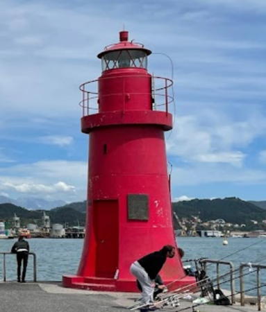
Date unknown. Active; focal plane 8 m (26 ft); red flash every 4 s. 8 m (26 ft) round tower with lantern and gallery, painted bright red; the lantern is silvery metallic. Massimo Farieri has the 2021 photo at right, Alessandro Baracchini has a photo, Trabas has Capt. Peter's photo, Antonio Gandolfo has a closeup street view, and Google has a satellite view. Located at the end of the Molo Italia on the waterfront of downtown La Spezia, marking the entrance to the traditional inner harbor. Accessible by walking the pier. Site open, tower closed. . ARLHS ITA-294; EF-1820; Admiralty E1290; NGA 7764.
* Darsena Duca degli Abruzzi Range Front
Date unknown. Active; focal plane 21 m (69 ft); flash every 3 s, white, red or green depending on direction. Light mounted on the roof of the main building of the La Spezia naval station. Trabas has Capt. Peter's photo and Google has a street view and a satellite view. Site status unknown. EF-1755; Admiralty E1312; NGA 7744.
* Pegazzano (Darsena Duca degli Abruzzi Range Rear)
1915. Active; focal plane 48 m (157 ft); white light, 2 s on, 2 s off, visible only on or near the range line. 13 m (43 ft) pentagonal masonry tower with a masonry lantern room; the light is displayed through a window. Tower painted white, except the two front faces are painted in a red and white checkerboard pattern. Trabas has Capt. Peter's photo, Andreas Köhler has a photo, and Google has a 2023 street view and a satellite view. Located in a hillside park in the Pegazzano neighborhood, off the Via Sant'Eutichiano, 1 km (0.6 mi) northwest of the front light. Site open, tower closed. ARLHS ITA-165; EF-1765; Admiralty E1312.1; NGA 7748.

Molo Italia Light, La Spezia, May 2021
Google Maps photo by Massimo Farieri
La Spezia Diga Foranea Estremità Ovest (Breakwater West End)
Date unknown. Active; focal plane 11 m (36 ft); green flash every 4 s. 9 m (30 ft) round tapered concrete tower, with lantern and gallery, painted green. Francesca Bezzan has a good photo, Carla Piccolini has a 2009 photo, Trabas has Capt. Peter's photo, Capt. Gerry Hare has a photo, and Google has a satellite view. This light and the next one frame the main entrance to the harbor, the Passo di Ponente. Located on the west end of the outer breakwater (diga foranea) of La Spezia just off Punta Santa Maria della Spezia. Accessible only by boat. Site and tower closed. ARLHS ITA-216; EF-1730; Admiralty E1269; NGA 7724.
Punta Santa Maria della Spezia (Punta Santa Marinella)
1913. Active; focal plane 11 m (36 ft); red flash every 4 s. 7 m (23 ft) round tower with lantern and gallery, painted bright red; lantern painted white. Trabas has Capt. Peter's photo, Capt. Gerry Hare has a photo, and Google has a satellite view. Located on a mole on the west side of the entrance to La Spezia. Site and tower closed. ARLHS ITA-251; EF-1725; Admiralty E1268; NGA 7720.
Torre della Scuola
Date unknown (1920s or 1930s). Active; focal plane 16 m (52 ft); two white flashes every 6 s. A short post light mounted on one corner of the Torre della Scuola, a ruined pentagonal stone fortress. Trabas has Capt. Peter's closeup photo and Bing has an aerial view. Located in the entrance to La Spezia, about 300 m (330 yd) off the northeast corner of the Isola Palmaria. Accessible only by boat. Site and tower closed. EF-1716; Admiralty E1263; NGA 7708.
Isola del Tino (Faro San Venerio) (1)
1840. Inactive since 1884. Approx. 13 m (43 ft) round cylindrical stone tower with gallery, attached to one corner of a 2-story keeper's house; lantern removed. Tower painted red. Buildings unpainted. A photo is at right, Benedetta Regazzi has a good 2010 photo, Marinas.com has aerial photos, and Bing has an aerial view. The tower has been out of use since it was replaced by a taller tower a few feet away in 1884. The Isola del Tino is a wedge-shaped island off the western entrance to the Golfo della Spezia, the harbor of La Spezia. The light station is perched high atop the wedge facing the Ligurian Sea. Accessible only by boat. The site is a military reservation and is generally closed, but it is open each year on September 13, the festival of San Venerio. Tower closed. ARLHS ITA-058.
Isola del Tino (Faro San Venerio) (2)
1884 (station established 1840). Active; focal plane 117 m (384 ft); three white flashes every 15 s. 24 m (79 ft) round cylindrical masonry tower with lantern and double gallery, painted white; lantern dome is gray metallic. A photo is at right, Trabas has Capt. Peter's photo, and Benedetta Regazzi has a good 2010 photo. Located adjacent to the original lighthouse. ARLHS ITA-282; EF-1708; Admiralty E1262; NGA 7696.

Isola del Tino Light, La Spezia, September 2017
Google Maps photo by Elle

Eastern City of Genova (Portofino Area) Lighthouses
In 2015 Genova Province was replaced by the Metropolitan City of Genova. The Gulf of Tigullio is a open bay about 25 km (15 mi) east of downtown Genova. Rapallo is a town of about 30,000 residents at the head of the gulf; Portofino is a historic fishing village now a popular resort on the cape at the west end of the gulf.
#Rapallo
Date unknown (station established 1918). Removed around 2019. This was a 5.5 m (18 ft) round tower with gallery, rising from a 1-story pier house. Tower painted white. Nycko Heimberg has a photo, and Andreas Köhler has a closeup, but the light is no longer seen in Google's satellite view or in Capt. Peter's photo posted by Trabas. Located at a right-angle bend in the main breakwater of Rapallo, the Calata Andrea Doria. Site open, tower closed. Admiralty E1255; NGA 7660.
* Portofino Entrance
1913. Active; focal plane 9 m (30 ft); green flash every 3 s. The light is mounted on a bracket on the side of a 3-story waterfront building (apparently the port captain's office). Trabas has Capt. Peter's photo, the light is at the right edge in a photo, and Google has a satellite view. Located on the Calata Marconi in Portofino. Site open. EF-1680; Admiralty E1246; NGA 7640.
* Portofino
1917. Active; focal plane 40 m (131 ft); white flash every 5 s. 12 m (39 ft) square cylindrical masonry tower with lantern and gallery, attached to the front of a 2-story masonry keeper's house. Lighthouse painted white; lantern dome is gray metallic. Davide Papalini's photo is at right, Trabas has Capt. Peter's photo (also seen at right), Ferrighi has a photo, Marco Molinari has a good view from the sea, Fabrizio Franceschetti has a 2021 view from the sea, Luca Lupi has a closeup, Huelse has a fine historic postcard view, Marinas.com has aerial photos, and Google has a sea view as well as a satellite view. The famous resort town of Portofino is located behind the shelter of a steep promontory, with this lighthouse on the point. The light station is accessible by a popular walk of about 1200 m (3/4 mi) from the town. Site open, tower closed. . ARLHS ITA-131; EF-1675; Admiralty E1244; NGA 7636.
* Camogli (2)
Date unknown (station established 1863). Active (?); focal plane 11 m (36 ft); white flash every 3 s. 7 m (23 ft) round cylindrical white concrete tower. Lantern removed. Trabas has Capt. Peter's closeup photo, Wikimedia has photos, a 2023 photo is available, and Google has a sea view and a satellite view. In early 2012 the Admiralty listed the light as "temporarily extinguished," and Alessio Sbarbaro's May 2012 photo shows that the lantern was removed. It was replaced by a new lantern. Located at the end of the breakwater at Camogli, a resort town on the west side of the Portofino Peninsula; accessible by walking the pier. Site open, tower closed. ARLHS ITA-189; EF-1671; Admiralty E1236; NGA 7624.
* Recco Molo di Levante
Date unknown. Active (privately maintained); focal plane 7 m (23 ft); green flash every 3 s. 6 m (20 ft) post centered on a round stone tower. The tower is unpainted; post painted green. Paolo Maggiani has a 2023 photo, Trabas has a closeup photo by Capt. Peter, Marco Traggia has a closeup street view, and Google has a street view and a satellite view. Located on the east mole at Recco, a neighborhhod on the north side of Camogli; accessible by walking the pier. Site open, tower closed. EF-1670.7; Admiralty E1234.

Portofino Light, Portofino, 2021
photo copyright Capt. Peter Mosselberger; used by permission
* Recco Molo di Santa Anna
Date unknown. Active (privately maintained); focal plane 7 m (23 ft); red flash every 3 s. 6 m (20 ft) post attached to the side of a round stone tower. The tower is unpainted; post painted red-orange. Trabas has a closeup photo by Capt. Peter, Graham Fielder has a photo, Davide Garufi has a street view, and Google has a satellite view. Located on the west mole at Recco; accessible by walking the pier. Site open, tower closed. EF-1670.8; Admiralty E1234.1.

Lighthouses of Genova (Genoa)
The historic city of Genoa was a dominant commercial and naval power in the Mediterranean throughout Medieval times and into modern times as well. The population is about 600,000 within the urban area. Most of the lighthouses of Genoa are operated by the Genoese port authority, the Autorità di Sistema Portuale del Mar Ligure Occidentale; the Navy operates only the Punta Vagno lighthouse and the Lanterna di Genova.
* Punta Vagno (2)
1948 (station established 1931). Active; focal plane 26 m (85 ft) (?); three long (2 s) white flashes every 15 s. 9 m (30 ft) (?) round concrete (?) tower with lantern and gallery, painted white; lantern roof painted black. Chris Goldberg's photo is at right, Trabas has Capt. Peter's photo, a closeup photo is available, Lightphotos.net has a photo, Google has a street view, and Bing has an aerial view. Standing on the mainland, this lighthouse guides ships approaching the eastern entrance to the harbor of Genova. We need better information concerning this station. The original lighthouse, an 8 m (26 ft) round masonry tower, was destroyed during World War II. The present lighthouse appears taller than the indicated 9 m and its focal plane appears higher than 26 m. Located near the foot of the Via Piave on the east side of downtown Genoa. Site open, tower closed. . ARLHS ITA-151; EF-1575; Admiralty E1230; NGA 7612.
Molo Duca di Galliera (Genoa Breakwater)
Date unknown (station established 1909). Active; focal plane 18 m (59 ft); red flash every 4 s. 15 m (49 ft) square skeletal tower with lantern and gallery. Entire lighthouse painted red. Trabas has Capt. Peter's photo, David Wyndoze has a view from the sea, Evgeny Ustinov has a distant street view, and Google has a satellite view. Located at the end of the breakwater on the south side of the entrance to the old harbor of Genova. The pier is not walkable but there is a boat service that carries fishermen to the end of the pier. Site open, tower closed. ARLHS ITA-063; EF-1639; Admiralty E1219; NGA 7580.
* Marina Fiera East Mole
Date unknown. Active (privately maintained); focal plane 14 m (46 ft); green flash 4 s. 7 m (23 ft) round bottle-shaped tower mounted on a square masonry tower. Entire lighthouse painted green. Trabas has Capt. Peter's photo and Google has a satellite view. Located at the end of the east mole of a basin on the east side of Genova. Accessible by walking the pier. Site open, tower closed. EF-1640; Admiralty E1220; NGA 7584.
Molo Vecchio (Lanternino) (2?)
Date unknown (station established 1820). Active; focal plane 8 m (26 ft); flashing green light. 5 m (17 ft) round concrete tower with lantern and gallery, painted green. Trabas has Eckhard Meyer's photo, Andrea Biffi has a street view, and Google has a satellite view. Huelse has a postcard view showing the 1820 version of this light, known as the "Lanternino" or the Faro del Mandraccio, at the base of the taller Torre dei Greci. Both lighthouses were demolished in 1929 when the harbor was redeveloped. Located on the Molo Vecchio (Old Mole), a major commercial pier on the east side of Genova's old harbor. Site and tower closed, although the light can be seen from nearby. Admiralty E1226; NGA 7604.
Punta Vagno Light
Punta Vagno Light, Genoa, May 2008
Flickr Creative Commons photo
by Chris Goldberg
** La Lanterna di Genova (2)
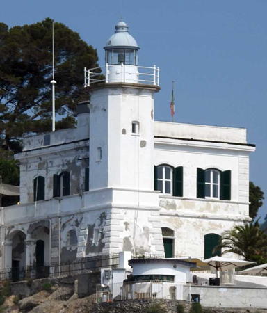
1543 (station established in the 12th century). Active; focal plane 117 m (384 ft); two white flashes, separated by 5 s, every 20 s. 77 m (253 ft) two-stage square cylindrical stone tower with lantern and two galleries, one at the top of each stage. The tower is unpainted gray stone; the lantern dome is painted in a red and white checkerboard pattern. Holm Pajung's 2021 photo is at the top of this page, Carlo Natale has a November 2009 photo, Trabas has Capt. Peter's photo, Huelse has a historic postcard view, Marinas.com has aerial photos, and Google has a street view and a satellite view. This famous and magnificent lighthouse is the symbol of Genoa and the arms of the city are painted on the sides of the lower stage. The Lanterna is the world's second tallest traditional lighthouse (after Île Vierge, France) and also the world's second oldest light station (after Spain's Torre de Hércules). It is believed that the original lighthouse (which was nearly as tall) stood on this site as early as 1128 (another source says 1161) and a lamp fueled by olive oil was installed in 1326. Columbus had an uncle, Antonio Columbo, who was appointed a keeper here in 1449 (a century before the present lighthouse was built). The upper portion of the tower was damaged during fighting with a French army in 1506, leading eventually to the construction of the present tower. A Fresnel lens was installed in 1840 and the present rotating first order lens was installed in 1913. A museum has been built nearby in part of the fortifications that surround the tower. The lighthouse was restored by the Provincia di Genova between 1995 and 2004. Visitors are allowed to climb to the first gallery, 36 m (118 ft) above the foot of the tower and 76 m (249 ft) above the water. Located on the Via al Largo della Lanterna within walking distance of the ferry terminal in downtown Genoa. Site open; tower and museum open on weekends and holidays, or by appointment. . ARLHS ITA-177; EF-1569; Admiralty E1206; NGA 7568.
Voltri Breakwater
Date unknown. Active; focal plane 16 m (52 ft); white or green light, depending on direction; 1 s on, 1 s off. Approx. 13 m (43 ft) round cylindrical concrete tower with lantern and gallery. The tower is unpainted white concrete except for a green band painted at the gallery level. Trabas has a good photo by Capt. Peter and Google has a satellite view. Voltri is a modern commercial harbor developed about 11 km (7 mi) west of Genova. Located at the west end of the detached breakwater at Voltri. Accessible only by boat. Site and tower closed. EF-1580; Admiralty E1202; NGA 7528.

Savona Province Lighthouses
* Capo di Vado (Vado Ligure)
1883. Active; focal plane 43 m (141 ft); four white flashes every 15 s. 34 m (112 ft) octagonal cylindrical masonry tower with lantern and gallery, attached to the seaward side of a 3-story masonry keeper's house; in an unusual design, the tower attaches to all three floors of the house. Entire lighthouse painted white. Google has the closeup 2023 street view seen at right, Trabas has a photo by Capt. Peter, Marco Bernardis has a 2021 photo, a 2008 photo is available. The Marinas.com aerial photos and a Google satellite view reveal that the lighthouse is actually in the middle of the Porto di Vado interchange on the Via Aurelia (SS-1) expressway. Capo di Vado is an prominent cape about 40 km (25 mi) west of Genova. Located on the SP-1 about 1.5 km (1 mi) south of Vado Ligure. Site open, tower closed. ARLHS ITA-017; EF-1514; Admiralty E1172; NGA 7396.
* Capo delle Mele (Capo Mele)
1856. Active; focal plane 94 m (308 ft); three white flashes every 15 s. 25 m (82 ft) square cylindrical masonry tower with octagonal masonry watch room, lantern and gallery, attached to the seaward side of a 3-story red brick keeper's house. A large Fresnel lens is in use. Tower painted white with buff trim; lantern dome is gray metallic. Trabas has Philippe Le Bret's photo, Gianpiero Lafornara has a 2021 photo, a 2007 photo is available, Huelse has a historic postcard view, Marinas.com has aerial photos, and Google has a closeup street view and a good satellite view. This handsome and historic lighthouse is built at the western entrance to the Golfo di Genova. Heavily damaged during World War II, it was restored in 1947-48. Located beside the Via Aurelia (SS-1) expressway above the point of the cape, on the northeast side of Andora. Site open, tower closed. . ARLHS ITA-015; EF-1506; Admiralty E1168; NGA 7356.

Imperia Province Lighthouses
Imperia is a city of about 45,000 residents near the western end of the Italian Riviera. It was formed in 1923 by combining Oneglia, on the east side of the mouth of the Impero River, with Porto Maurizio on the west side. The two harbors serve mostly yachts and other recreational vessels.

* Oneglia Molo di Levante (Molo Lungo) (2)
Date unknown (station established 1858). Active; focal plane 10 m (33 ft); two green flashes every 7 s. 6 m (20 ft) round masonry tower with lantern and gallery, painted green. Trabas has Capt. Peter's closeup photo, another photo and a 2008 closeup are available, Calogero Barbarotto has a 2023 closeup, and Google has a sea view, a street view and a satellite view. Located at the end of the Oneglia breakwater on the east side of Imperia. Accessible by walking the mole. Site open, tower closed. ARLHS ITA-118; EF-1498; Admiralty E1162; NGA 7340.

Capo di Vado Light, Vado Ligure, September 2023
Google Maps street view
* Oneglia Molo di Ponente (Molo Corto)
Date unknown (station established 1881). Active; focal plane 8 m (26 ft); two red flashes every 7 s. 6 m (20 ft) round masonry tower with lantern and gallery, painted red; lantern is gray metallic. Trabas has a photo by Heike and Friedrich Klett, Francesco Spaccamonte has a 2021 photo, and Google has a sea view, a satellite view and a distant street view across the harbor. Located at the end of the short west mole at Oneglia on the east side of Imperia. Accessible by walking the mole. Site open, tower closed. EF-1502; Admiralty E1164; NGA 7344.
* Oneglia Molo di Sottoflutto (Inner Mole)
Date unknown. Active; focal plane 9 m (30 ft); two red flashes every 6 s. 6 m (20 ft) round masonry tower with lantern and gallery, painted red; lantern roof is white. Trabas has Capt. Peter's closeup photo, Köhler has a photo, Francesco Spaccamonte has a 2020 photo, and Google has a sea view, a satellite view, and a distant street view across the harbor. Located at the end of the west inner mole at Oneglia. Accessible by walking the mole. Site open, tower closed. EF-1500; Admiralty E1163.
* Porto Maurizio (Imperia) Molo di San Lazzaro
Date unknown. Active; focal plane 8 m (26 ft); light characteristic unknown. 7 m (23 ft) round masonry tower with lantern and gallery, painted green; lantern is gray metallic. The harbor at Imperia was expanded considerably around 2009-10, and this lighthouse was relocated from the end of the old east breakwater to an elbow of the new one. Trabas has Capt. Peter's closeup photo and Google has a satellite view and a distant sea view. Accessible by walking the mole. Site open, tower closed. EF-1488; Admiralty E1157.5.
* Porto Maurizio (Imperia) (2)
Date unknown (1940s or early 1950s) (station established 1881). Active; focal plane 11 m (36 ft); white light, 2 s on, 2 s off. 11 m (36 ft) round masonry tower with lantern and gallery. Entire lighthouse painted white; lantern roof is gray metallic. A portion of Google's 2021 street view is seen at right, Trabas has a good photo, and Francesco Spaccamonte has a 2021 closeup. In 2009 the mole was extended considerably and the mole light was replaced by a new red tower (next entry). Google has a satellite view and a distant sea view. Located about 150 m (500 ft) from the end of the breakwater (south) mole of Porto Maurizio in the town of Imperia. Accessible by walking the mole. Site open, tower closed. ARLHS ITA-086; EF-1478; Admiralty E1156; NGA 7320.
* Porto Maurizio (Imperia) Molo di Ponente (2)
2009. Active; focal plane 9.5 m (31 ft); red flash every 3 s. 8 m (26 ft) round masonry tower with lantern and gallery, painted red; gallery rail painted white. Trabas has Capt. Peter's photo, Elena Gladkova has a 2020 closeup, and Google has a street view, a sea view, and a satellite view. The Navy's page has photos of the original light. Located at the end of the extended south mole of Porto Maurizio in Imperia. Accessible by walking the mole. Site open, tower closed. EF-1485; Admiralty E1157; NGA 7328.


Porto Maurizio Light, Imperia, July 2021
Google Maps street view

* Capo dell'Arma (Punta Verde, San Remo) (2)
1948 (station established 1912). Active; focal plane 50 m (164 ft); two white flashes every 15 s. 15 m (49 ft) round cylindrical masonry tower with lantern and gallery, centered on the roof of a 2-story masonry keeper's house. Lighthouse painted white; the keeper's house is painted white with a black horizontal band encircling the house. Trabas has a good photo by Eckhard Meyer, Wikimedia has a good 2010 photo, Ferrighi also has a photo, Alessandro Morabito has a 2021 closeup, Marinas.com has aerial photos, and Google has a street view and a satellite view. Not far east of San Remo, this lighthouse marks a prominent cape. It was rebuilt in 1947-48 after being destroyed during World War II. Located on the point of the cape above the SS-1 coastal highway, about 3 km (2 mi) southwest of Arma di Taggia. Site and tower closed, but the lighthouse can be seen easily from the highway. . ARLHS ITA-013; EF-1474; Admiralty E1152; NGA 7316.
* San Remo (2?)
Date unknown (station established 1866). Inactive. Approx. 7 m (23 ft) round cylindrical white tower with lantern and gallery. Capt. Peter's 2022 photo is at right and Google has a street view and a satellite view. We need information on the history of this lighthouse. Findlay's 1879 light list has 1866 as the date of the first lighthouse and a 1904 light list has 1894 as the date of a possible second lighthouse. Located on the quay at San Remo, in front of the Coast Guard office. Site open, tower closed.

Information available on lost lighthouses:

  • Torre dei Greci (1324(?)-1929), Genova. This was a tall tower on the east side of the harbor entrance; if the 1324 date is correct it predated the Lanterna. The nineteenth century version of the lighthouse is seen on the right in a postcard view posted by Huelse; a 1904 light list has 1883 as the date of this light. The lighthouse was demolished in 1929 to accommodate redevelopment of the harbor.

Notable faux lighthouses:


San Remo Light, San Remo, May 2022
photo copyright Capt. Peter Mosselberger; used by permission

Adjoining pages: South: Tuscany | West: Alpes-Maritimes (French Riviera)

Return to the Lighthouse Directory index | Ratings key

Posted May 1, 2006. Checked and revised March 14, 2024. Lighthouses: 32. Site copyright 2024 Russ Rowlett and the University of North Carolina at Chapel Hill.