Lighthouses of Japan: Miyazaki

The nation of Japan, known in Japanese as Nihon or Nippon (日本), occupies an archipelago off the east coast of Asia. The four main islands are Hokkaidō in the north, Honshū (the largest), Shikoku in the south, and Kyūshū in the southwest. The country includes thousands of other islands of all sizes; among them the Ryūkyū (Nansei) Islands are a long chain extending to the southwest and including the large island of Okinawa, and the Nanpō Islands are another long chain extending south into the Pacific Ocean. Much of Japan is mountainous but the coastal regions are densely populated and urbanized; the country's population is about 126 million.

Located at the southwestern end of the Japanese archipelago, the island of Kyūshū is divided into seven prefectures. This page includes lighthouses of Miyazaki Prefecture, located on the southeastern coast of the island facing east on the open Pacific Ocean.

In Japanese, the word for a lighthouse is tōdai or toudai (灯台). The words saki and misaki are for capes and headlands, hana ("nose") is a promontory, hantō is a peninsula, shima (also spelled sima or jima) is an island, bae is a reef, iwa or shi is a rocky reef, amase or se is a shoal, wan is a bay, nada is a sound or basin, kaikyō is a strait, kawa is a river, and or minato is a harbor.

Lighthouses in Japan are operated and maintained by the Japanese Coast Guard's Maritime Safety Agency. There is at least one Coast Guard Section Office in each prefecture, often two or more. Miyazaki Prefecture has only one office, at Miyazaki City.

ARLHS numbers are from the ARLHS World List of Lights. JCG numbers are the Japanese Coast Guard's light list numbers. Admiralty numbers are from volume M of the Admiralty List of Lights & Fog Signals. U.S. NGA List numbers are from Publication 112.

General Sources
Lighthouses in Japan - Miyazaki
This site has photos and data for the major lighthouses.
Lighthouse of Japan - Miyazaki
This comprehensive site covers most Japanese lighthouses.
Form of a Lighthouse - Miyazaki
Another site with many photos and visitor notes, cited below as FOAL.
Lighthouse Visits
This site has photos for all of the lighthouses in this area.
Online List of Lights - Japan
Photos by various photographers posted by Alexander Trabas.
Our Lighthouses of Miyazaki Prefecture
A comprehensive collection of photos of Miyazaki lighthouses.
Miyazaki Lighthouse Photo Gallery
Excellent photos of the major lighthouses posted by the Miyazaki Coast Guard Office.
Region Ten Lighthouses
Information and photos posted by the Tenth Coast Guard Region office, which is responsible for Miyazaki Prefecture.
Navionics Charts
Navigational chart for southeastern Kyūshū.
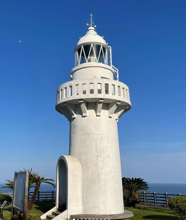

Hososhima Light, Hyūga, May 2023
Instagram photo by Wakigar
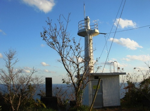
Nobeoka City Lighthouses
* Kitaura Kō
1963. Active; focal plane 9.5 m (31 ft); red light, 3 s on, 3 s off. 7.5 m (25 ft) concrete post attached to a square 1-story concrete equipment room. Entire lighthouse is red. Trabas has a photo, FOAL has additional photos and Google has a street view and a satellite view. Located at the end of the south (main) breakwater of Kitaura harbor. Accessible by walking the pier. Site open, tower closed. ARLHS JPN-2135; JCG-6777; Admiralty M4905.4; NGA 10640.
Bakuchi Bae
Date unknown. Active; focal plane 17 m (56 ft); white flash every 3 s. 13 m (43 ft) round cylindrical white concrete tower with gallery. FOAL's page has photos, Trabas has a photo, and Google has a satellite view. NGA lists this light as "Kitaura Ko approach." Located on a rocky reef in the channel between the mainland and Shimanoura Shima, on the south side of Kitaura harbor. Accessible only by boat. Site and tower closed. ARLHS JPN-2133; JCG-6779; Admiralty M4904.8; NGA 10652.
Gojo (Gozyo) Se
1969. Active; focal plane 27 m (89 ft); white flash every 4 s. 11 m (36 ft) round cylindrical concrete tower. Entire lighthouse is white. The lighthouse is at the right in a distant view, FOAL's Shimanoura page has several photos (halfway down the page), Lighthouse Visit has a distant view (2/3 the way down the page), Trabas has a distant view, and Google has a satellite view. Located on a small island just off the end of a detached breakwater off the west side of Shimanoura Shima. Accessible only by boat. Site and tower closed. JCG-6774.7; Admiralty M4904.2; NGA 10650.
Shimanoura (Simanoura, Shimano Ura) Shima
1937. Active; focal plane 192 m (630 ft); two white flashes every 7 s. 8 m (26 ft) concrete post mounted on a rectangular 1-story concrete equipment room. Entire lighthouse is white. The Coast Guard has a page of photos including the one at right, FOAL's Shimanoura page has several photos, Uni Murasaki has a 2022 photo, the light is atop the ridge in a distant view of the harbor, and Google has a satellite view. Shimanoura Shima is a substantial island, about 3 km (1.8 mi) by 2 km (1.2 mi), off the entrance to Shimanoura Bay. The island is inhabited and accessible by passenger ferry. Located on the highest point of the island. Accessible by a hiking trail. Site open, tower closed. . ARLHS JPN-562; JCG-6774; Admiralty M4904; NGA 10648.
Shimage (Shimake, Simake) Bae
Date unknown. Active; focal plane 21 m (69 ft); two white flashes every 5 s. 18 m (59 ft) round concrete tower with double gallery, mounted on a concrete base. Lighthouse painted black with one red horizontal band. Trabas has a photo and FOAL's page has distant views but the light is only a faint blur in Google's satellite view. Located on an isolated rock about 5 km (3 mi) east of the entrance to Nobeoka harbor. Accessible only by boat. Site and tower closed. JCG-6771; Admiralty M4903; NGA 10680.
* Nobeoka Kō Entrance
Date unknown. Active; focal plane 64 m (210 ft); continuous white light. 6 m (20 ft) square concrete enclosure supported by concrete piles and set into a cliff. The light is shown through a square window. Entire lighthouse is white. Trabas has a closeup photo, FOAL's page for the light has good photos, Lighthouse Visit has photos, and another photo (search for 6770) is available. The light is barely visible in Google's satellite view; a street view shows the ladder that leads (straight up the cliff!) to the light. The light illuminates the end of the north breakwater at the entrance to the Gokase River in Nobeoka. Located just above the coastal road (highway 212) at the foot of a mountain on the east side of Nobeoka; limited parking is nearby. Site open, tower closed. JCG-6770; Admiralty M4902.4.
Shimanoura Shima Light
Shimanoura Shima Light, Nobeoka
Japanese Coast Guard Miyazaki Office photo
Nobeoka (Totoro) Shinko Breakwater North Head
Date unknown. Active; focal plane 18 m (59 ft); two green flashes every 6 s. 11 m (36 ft) round concrete tower, flared at the top, attached to a small equipment shelter. Entire lighthouse is white. FOAL's page has photos, Trabas has a closeup photo, and Google has a satellite view and a distant street view of the two breakwater lights. Located at the north end of the detached outer breakwater of the Totoro harbor in southern Nobeoka. Accessible only by boat. Site status unknown. ARLHS JPN-2143; JCG-6764; Admiralty M4900; NGA 10688.
Nobeoka (Totoro) Shinko Breakwater South Head
Date unknown. Active; focal plane 14 m (46 ft); two red flashes every 6 s. 9.5 m (31 ft) concrete post attached to a rectangular 1-story concrete equipment room. Entire lighthouse is red. FOAL's page has photos, Trabas has a closeup photo, and Google has a satellite view and a distant street view of the two breakwater lights. Located at the south end of the detached outer breakwater of the Totoro harbor in southern Nobeoka. Accessible only by boat. Site status unknown. ARLHS JPN-2144; JCG-6765; Admiralty M4900.04; NGA 10692.

Kadogawa Town Lighthouses
Biro Shima (Biro Jima, Hyūga Biroshima)
Date unknown. Active; focal plane 86 m (282 ft); white flash every 3 s. 12 m (39 ft) octagonal concrete tower with gallery. Entire lighthouse is white. Trabas has a distant view, FOAL has a distant view (third row, left), Lighthouse Visit has a very distant photo, and Google has a satellite view. Located atop a small island about 6 km (3.5 mi) east of Nabe Saki. Accessible only by boat. Site status unknown. ARLHS JPN-2124; JCG-6763; Admiralty M4898.6; NGA 10708.
Nabe Saki
1949. Active; focal plane 38 m (125 ft); four white flashes every 15 s. 10 m (33 ft) concrete post mounted on a square 1-story concrete equipment room. Entire lighthouse is white. Our Miyazaki Lighthouses has photos, FOAL's page also has photos, Trabas has a closeup, and Google has a satellite view. Located at the cape on the north side of the entrance to Ozue Bay, about 8 km (5 mi) northeast of Hyūga. Accessible by a hiking trail; local guidance will be needed. Site open, tower closed. ARLHS JPN-386; JCG-6758; Admiralty M4897; NGA 10712.
Kadogawa (Kadokawa) East Breakwater (Ozue Wan Approach)
Date unknown. Active; focal plane 16 m (52 ft); two red flashes every 6 s. 11 m (36 ft) round concrete tower, flared at the top, attached to a small equipment shelter. Entire lighthouse is red. Trabas has a closeup photo, FOAL's page has photos, a 2023 view along the breakwater is available, and Google has a satellite view. Located at the west end of a detached breakwater sheltering the east entrance to Kadogawa harbor. Accessible only by boat. Site open, tower closed. JCG-6758.5; Admiralty M4899.7; NGA 10720.
* Kadogawa Kō South Breakwater
1960. Active; focal plane 11 m (36 ft); green light, 2 s on, 2 s off. 7.5 m (25 ft) round concrete tower centered on a square 1-story concrete equipment shelter. Entire lighthouse is white.A 2020 photo is at right, Our Miyazaki Lighthouses has photos, FOAL's page has photos, Trabas has a good photo, and Google has a satellite view and a street view across the harbor. Located at the end of the south breakwater of Kadogawa. Accessible by walking the pier. JCG-6761; Admiralty M4899; NGA 10724.
Oto Shima Breakwater
Date unknown. Active; focal plane about 12 m (39 ft); three red flashes every 12 s. 10 m (33 ft) round concrete tower, flared at the top, attached to a small equipment shelter. Entire lighthouse is red. FOAL's page has photos, Lighthouse Visit has photos (last lighthouse on the page), Trabas has a photo, and Google has a satellite view and a distant street view across the harbor. Located at the west end of a breakwater extending from Oto Shima, an island sheltering Kadogawa harbor. Accessible only by boat. Site open, tower closed. JCG-6762; Admiralty M4898.8.

Kadogawa Kō South Breakwater Light, Kadogawa, March 2020
Kadogawa Tourism Association photo

Hyūga City Lighthouses
Hososhima North (Makishima) Breakwater
Date unknown. Active; focal plane 17 m (56 ft); green light, 3 s on, 3 s off. 11 m (36 ft) round concrete tower, flared at the top, attached to a small equipment shelter. Entire lighthouse is white. Trabas has a photo, FOAL has a photo (halfway down the page) and Google has a satellite view. Located at the end of a breakwater sheltering Hososhima harbor. Site status unknown. ARLHS JPN-2128; JCG-6752.9; Admiralty M4898.7; NGA 10740.
* Hososhima (Hososima, Hosojima) (2)
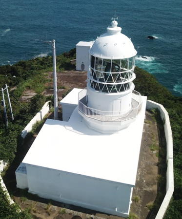
1941. Active; focal plane 101 m (331 ft); flash every 5 s, alternately red and white. 11 m (36 ft) round cylindrical concrete tower wth lantern and gallery. Entire lighthouse is white. A 2023 photo is at the top of this page, Coast Guard has several good photos, Lighthouse-Japan.com has a page with photos, FOAL's page has photos, Trabas has a photo, Our Miyazaki Lighthouses has photos, Mov Nishida has a street view, and Google has a satellite view. This light station commands a spectacular view of the open Pacific Ocean. Accessible by road and a short hike; some parking is available. Located at the tip of a promontory on the south side of Hososhima harbor, about 5 km (3 mi) east of Hyūga. Site open, tower closed. . ARLHS JPN-140; JCG-6748; Admiralty M4896; NGA 10736.
Mimitsu Kō Entrance
Date unknown. Active; focal plane 23 m (75 ft); continuous white light. 9.5 m (31 ft) square skeletal tower painted white. Trabas has a photo, FOAL has a photo, Our Lighthouses has two photos, and Google has a satellite view. The spotlight illuminates the breakwater on the other side of the entrance. Located on a steep bluff on the north side of the entrance to Mimitsu harbor. Site status unknown. JCG-6747; Admiralty M4895.
Mimitsu Kō (Tatsugami Bae)
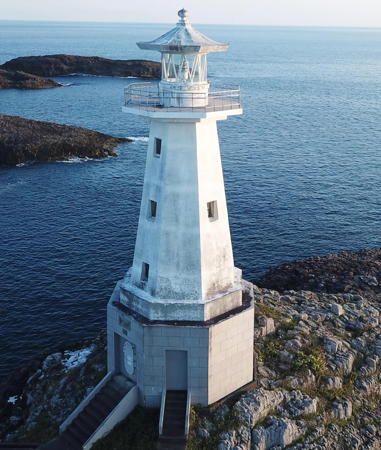
1934. Active; focal plane 23 m (75 ft); white flash every 4 s. 17 m (56 ft) octagonal pyramidal concrete tower wth lantern and gallery, mounted on an octagonal 1-story concrete base. The base is gray, and the rest of the lighthouse is white. Yukihiro Matsumura's 2023 photo is at right, Coast Guard has photos, Our Miyazaki Lighthouses has photos, FOAL's page has photos (lower half of the page), Trabas has a good photo, Robin Goodfellow has a 2018 drone view, and Google has a satellite view. The lantern roof gives this unusual lighthouse the appearance of having a hat. Located on a skerry off the end of the south breakwater of Mimitsu. Accessible only by boat. Site open, tower closed. . ARLHS JPN-2136; JCG-6746; Admiralty M4894; NGA 10748.

Mimitsu Kō Light, Hyūga, October 2023
Instagram photo by Yukihiro Matsumura

Takanabe Town Lighthouses
Kawaminami Kō
Date unknown. Active; focal plane 11 m (36 ft); continuous green light with a more intense flash every 6 s. 8.5 m (28 ft) concrete post attached to a square 1-story concrete equipment room. Entire lighthouse is white. FOAL has a photo, Trabas has a photo, and Google has a satellite view. Located at the end of the south breakwater of Kawaminami harbor in Takanabe. Site status unknown. ARLHS JPN-2132; JCG-6744; Admiralty M4892.6; NGA 10756.

Miyazaki City Lighthouses
The prefectural capital of Miyazaki is a city of about 400,000 residents.
* Tonda
1955. Active; focal plane 64 m (210 ft); white flash every 15 s. 9.5 m (31 ft) round cylindrical concrete tower wth lantern and gallery, attached to a concrete 1-story equipment shelter. Entire lighthouse is white. Tetsuro Iwakiri's 2021 photo is at right, Coast Guard has photos, Lighthouse-Japan.com has a page with photos, FOAL's page has photos, Our Miyazaki Lighthouses has photos, Trabas has a closeup, and Google has a satellite view and a distant street view. Located on a hill on the north side of the entrance to Tonda. The hill is a public park; the entrance and parking are on the northwest side. Site open, tower closed. . ARLHS JPN-672; JCG-6742; Admiralty M4890; NGA 10760.
* Miyazaki North Breakwater
Date unknown. Active; focal plane 13 m (43 ft); two red flashes every 6 s. 11 m (36 ft) round concrete tower, flared at the top, attached to a small equipment shelter. Entire lighthouse is red. Trabas has a closeup photo, FOAL's page has photos, and Google has a satellite view. Located at the end of the north breakwater of Miyazaki harbor. Accessible by walking the pier from the Miyazaki Seaside Park. Site open, tower closed. ARLHS JPN-2139; JCG-6741.6; Admiralty M4889.2; NGA 10762.
Miyazaki South Breakwater
Date unknown. Active; focal plane 16 m (52 ft); two green flashes every 6 s. 13 m (43 ft) round metal pylon standing on a large square solid stone base. Trabas has a photo, FOAL's page has photos and Google has a satellite view. Located near the end of the long south (main) breakwater of Miyazaki harbor. Site status unknown. JCG-6741.7; Admiralty M4889.4; NGA 10763.
Ao Shima
1969. Active; focal plane 13 m (43 ft); white flash every 4 s. 12 m (39 ft) round tapered concrete tower with double gallery. Entire lighthouse is white. This striking little lighthouse is often photographed; Alex Muntean has a good closeup, Hiroshi Ito has a 2020 closeup, the Coast Guard has photos, Trabas has a photo, FOAL's page for the lighthouse has photos, Our Miyazaki Lighthouses has photos, Robin Goodfellow has a drone view, and Google has a satellite view. Ao Shima is an island just off the coast about 12 km (7.5 mi) south of Miyazaki city. The island is connected to the mainland by a footbridge. Located on a rock ledge just off the eastern tip of the island; easily visible from shore. Site and tower closed. . ARLHS JPN-151; JCG-6739; Admiralty M4887; NGA 10768.

Tonda Light, Miyazaki, July 2021
Google Maps photo by Tetsuro Iwakiri
* Aoshima Kō East Breakwater
1964. Active; focal plane 13 m (43 ft); continuous green light with two more intense flashes every 10 s. 8.5 m (28 ft) concrete post attached to a 1-story concrete equipment room. Entire lighthouse is white. Our Miyazaki Lighthouses has an excellent closeup, FOAL's page has photos, Trabas has a closeup, and Google has a satellite view and a distant street view. Located at the end of the main breakwater of a harbor just south of Ao Shima. Accessible by walking the pier. Site open, tower closed. JCG-6738; Admiralty M4888; NGA 10772.
* Tosaki Hana
1951. Active; focal plane 91 m (299 ft); white flash every 8 s. 8.5 m (28 ft) semicircular cylindical concrete tower with lantern and gallery, rising from a 1-story concrete equipment building. Entire lighthouse is white. A 2023 photo is at right, Jun Omori has a 2020 closeup photo, Lighthouse-Japan.com has a page with photos, Our Miyazaki Lighthouses also has photos, FOAL's page for the lighthouse has photos, Trabas has a view from the rear of the lighthouse, and Google has a satellite view. Accessible by hiking the service road; parking is available opposite the entrance. Located on a prominent cape about 4 km (2.5 mi) southeast of Ao Shima. Site open, tower closed. . ARLHS JPN-681; JCG-6737; Admiralty M4886; NGA 10776.
Uchiumi Kō East (Offing) Breakwater
Date unknown. Active; focal plane 14 m (46 ft); two red flashes every 6 s. 9.5 m (31 ft) concrete post attached to a 1-story concrete equipment room. Entire lighthouse is red. Trabas has a photo, FOAL's photo (halfway down the page, on the left) is available, and Google has a satellite view. Located on a breakwater extending from a long peninsula sheltering Uchiumi harbor. Site open, tower closed. JCG-6736; Admiralty M4882; NGA 10784.
* Uchiumi Kō West Breakwater (?)
1926. Inactive since 2016 and possibly removed. 7.5 m (25 ft) square concrete tower attached to a 1-story concrete equipment room. Entire lighthouse is white. Our Miyazaki Lighthouses has photos, FOAL has additional photos, and Google has a satellite view. The lighthouse remains standing in Google's distant 2023 street view. Located at the end of the main breakwater of Uchiumi, a small port about 4 km (2.5 mi) south of Tosaki Hana. Accessible by walking the pier. Site open, tower closed. ex-JCG-6735; ex-Admiralty M4883; NGA 10780.
Kintyaku Shima (Kinchaku Jima, Kouchiumi)
1964. Active; focal plane 50 m (164 ft); three flashes every 13 s, white or red depending on direction. 10 m (33 ft) concrete post attached to a 1-story concrete equipment room. Entire lighthouse is white. Lighthouse-Japan.com has a page with photos, Our Miyazaki Lighthouses has photos, FOAL has additional photos (bottom of the page), Tetsuro Iwakiri has a 2018 photo, Trabas has a photo, Robin Goodfellow has a drone view, and Google has a satellite view. Located on an island just off the coast at Kouchiumi, about 18 km (11 mi) south of Miyazaki city. The island has been joined to the mainland by a breakwater, and it is possible to reach the lighthouse after walking across and climbing many steps. Site open, tower closed. ARLHS JPN-260; JCG-6732; Admiralty M4880; NGA 10796.

Tosaki Hana Light, Miyazaki, May 2023
Instagram photo by atsem758
Hyūga Nojima Kō
Date unknown. Active; focal plane 12 m (39 ft); green flash every 3 s. 9 m (30 ft) square skeletal tower, adjacent to a square 1-story equipment building. Light tower and equipment building were painted white. FOAL's page has photos, Trabas has a photo, and Google has a satellite view and a street view across the harbor. Located on the detached west breakwater of Nojima, the harbor sheltered by Kintyaku Shima. Accessible only by boat, although easily seen from shore. Site open, tower closed. JCG-6731; Admiralty M4881; NGA 10800.

Nichinan City Lighthouses
A large part of the rugged and scenic Nichinan coast, including most of the lighthouses, is protected as the Nichinan Kaigan (Nichinan Coast) Quasi-National Park.
* Udo Saki
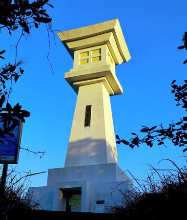
1967. Active; focal plane 45 m (148 ft); white light occulting twice every 6 s. 12 m (39 ft) white square Shinto-style tower. A 2021 photo is at right, Lighthouse-Japan.com has a page with several photos, the Coast Guard has additional photos, FOAL's page for the lighthouse has photos, Our Miyazaki Lighthouses has photos, Trabas has a closeup, and Google has a street view and a satellite view. This wonderful lighthouse was built in a traditional Japanese architectural style because it stands in a popular scenic area of the Nichinan Kaigan Quasi-National Park close to the famous Udo Jingū Shrine, which Japanese newlyweds visit on their honeymoons to pray for long life and happiness in their marriages. Accessible by road but parking is limited. Located on a prominent cape about 10 km (6 mi) north of Aburatsu. Site open, tower status unknown. . ARLHS JPN-707; JCG-6730; Admiralty M4876; NGA 10804.
Hadaka Bae
Date unknown. Active; focal plane 21 m (69 ft); white flash every 4 s. 14 m (46 ft) round white concrete tower. Trabas has a photo, Our Miyazaki Lighthouses has a distant view, Robin Goodfellow has a drone view, and Google has a satellite view. Located on a dangerous skerry off the entrance to Aburatsu, the seaport of Nichinan city. Accessible only by boat. Site status unknown. JCG-6725; Admiralty M4870; NGA 10808.
* Aburatsu Kō East Breakwater
1935. Active; focal plane 13 m (43 ft); red flash every 4 s. 8.5 m (28 ft) concrete post attached to a square 1-story concrete equipment room. Entire lighthouse is red. Our Miyazaki Lighthouses has good photos, FOAL's page has a photo (halfway down the page, on the left), Trabas has a closeup, and Google has a satellite view and a distant street view across the harbor. Located at the end of the east inner breakwater of Aburatsu. Accessible by walking the pier. Site open, tower closed. ARLHS JPN-2119; JCG-6727; Admiralty M4872; NGA 10828.
#Aburatsu Kō West Breakwater (1)
Date unknown. Replaced. This was an 8 m (26 ft) concrete post rising from a round 1-story concrete equipment room. Entire lighthouse was white. FOAL's page has a 2012 photo (halfway down the page, on the right). Trabas has a photo showing that the original lighthouse has been replaced by a simple post (focal plane 10 m (33 ft); green flash every 4 s). Google has a satellite view. Located at the end of the west inner breakwater of Aburatsu. This breakwater is not walkable. Site open, tower closed. ARLHS JPN-2121. New light: JCG-6728; Admiralty M4873; NGA 10832.

Udo Saki Light, Nichinan, February 2021
Instagram photo by Miyazaki Sightseeing Guide
* Aburatsu Entrance Range Rear
1963. Active; focal plane 67 m (220 ft); continuous green neon light. 16 m (52 ft) round concrete tower attached to a square 1-story concrete equipment room. Entire lighthouse is white. Our Miyazaki Lighthouses has a page with photos, Lighthouse Visit also has a page for the light, Trabas has a photo, and Google has a distant street view and an indistinct satellite view The front light is on a short brick pedestal. Located atop a tall headland in Izakibana Park, at the south end of Aburatsu harbor. Parking is available. Site open, tower closed. ARLHS JPN-2120; JCG-6722; Admiralty M4870.51; NGA 10824.
Odotsu Kō Detached Breakwater
1953. Active; focal plane 13 m (43 ft); red flash every 3 s. 9 m (30 ft) concrete post rising from a square 1-story concrete equipment room. Entire lighthouse is red. FOAL's page has photos, Trabas has a photo, and Google has a satellite view and a distant street view across the harbor. Located at the end of a detached breakwater outside Odotsu, a harbor on the south side of Aburatsu. Accessible only by boat. Site open, tower closed. JCG-6719; Admiralty M4866.8; NGA 10844.
* Odotsu Kō West Groin
1953. Active; focal plane 12 m (39 ft); green light, 3 s on, 3 s off. 9 m (30 ft) concrete post rising from a square 1-story concrete equipment room. Entire lighthouse is white. Our Miyazaki Lighthouses has photos, FOAL's page has photos, Trabas has a photo, and Google has a satellite view and a distant street view across the harbor. Located at the end of the west breakwater at Odotsu, a harbor on the south side of Aburatsu. Accessible by walking the pier. Site open, tower closed. ARLHS JPN-2145; JCG-6720; Admiralty M4867; NGA 10848.
* Meitsu Kō (South Breakwater)
Date unknown. Active; focal plane 15 m (49 ft); two green flashes every 6 s. 9.5 m (31 ft) concrete post rising from a square 1-story concrete equipment room. Entire lighthouse is white. FOAL's page has photos, Trabas has a closeup photo, and Google has a satellite view. NGA has the incorrect Admiralty number M4866 for this light. Located at the end of the detached south breakwater at Meitsu, a harbor to the south of the Odotsu harbor. Accessible only by boat. Site open, tower closed. JCG-6716; Admiralty M4866.5; NGA 10860.
* Kura Saki (Kurasaki)
1884. Active; focal plane 93 m (305 ft); two white flashes every 20 s. 14 m (46 ft) round cylindrical concrete tower with lantern and gallery, rising from a 1-story concrete keeper's house. Entire lighthouse painted white. A small secondary concrete tower (1973) carries a spotlight (JCG-6712) that shines its beam on a nearby skerry. The Miyazaki Coast Guard has photos, the Coast Guard has another page with two more photos and the history of the light station, FOAL's page has good photos, Our Miyazaki Lighthouse has excellent photos, Lighthouse-Japan.com has a page with several good photos, Trabas has a nice view, Robin Goodfellow has a 2017 street view, and Google has a satellite view. This is the oldest concrete lighthouse in Japan. According to the Coast Guard concrete was substituted for stone because of difficulties in transporting suitable stone to the site. The concrete is not reinforced but it has stood the test of time well. The lighthouse is located at the southern tip of a heavily forested island about 5 km (3 mi) south of the Aburatsu harbor entrance. The island is part of the quasi-national park. Passenger ferry service to the island is available and the lighthouse is accessible by a paved path. Site open, tower closed. . ARLHS JPN-304; JCG-6711; Admiralty M4864; NGA 10868.
Hyūga No Se (Hyugano Se)
Date unknown. Active; focal plane 22 m (72 ft); one short and one long green flash every 8 s. 19 m (62 ft) round concrete tower. Entire lighthouse is green. Trabas has a good photo, FOAL's page has photos, and Google has a satellite view and a very distant street view. Located on a reef off the entrance to Tonoura harbor. Accessible only by boat. Site open, tower closed. JCG-6713; Admiralty M4864.4; NGA 10872.

Kura Saki Light, Nichinan
Japanese Coast Guard Miyazaki Office photo

Kushima City Lighthouses
* Miyanoura Breakwater
Date unknown. Active; focal plane 17 m (58 ft); green flash every 4 s. 8.5 m (28 ft) concrete post rising from a square 1-story concrete equipment room. Entire lighthouse is white. FOAL has additional photos, Trabas has a closeup photo, and Google has a satellite view and a distant street view across the harbor. Located at the end of the detached breakwater at Miyanoura, a small port about 5 km (3 mi) north of Toi Misaki. Accessible only by boat. Site open, tower closed. ARLHS JPN-2138; JCG-6710.2; Admiralty M4861; NGA 10874.
**** Toi Misaki
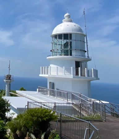
1929 (substantially rebuilt after World War II). Active; focal plane 255 m (837 ft); white flash every 15 s. 15 m (49 ft) octagonal cylindrical concrete tower rising from a 2-story concrete keeper's house. Entire lighthouse painted white. A 2022 photo is at right, Miyazaki Coast Guard Office has photos, the Coast Guard has another good photo and a page for the lighthouse, Lighthouse-Japan.com has a page with several excellent photos, FOAL's page also has excellent photos, Trabas has a closeup photo, Our Miyazaki Lighthouses has good photos, Yoshio Saito has a closeup street view, and Google has a satellite view. This is a staffed station; the station's office has a small museum and the drum-style Fresnel lens formerly used is on display. Toi Misaki (Cape Toi) is the southeastern tip of Kyūshū, making this lighthouse the principal landfall light for ships arriving from the Philippine Sea to the south. The light has a listed range of 23 nautical miles (42.5 km or 26.5 mi). The lighthouse was heavily damaged by American air raids in July 1945; it was returned to service after reconstruction in 1951. Located on the heights above the cape. Accessible by road and a paved walkway; parking provided. Site and museum open; the base of the tower is usually open, and visitors can climb exterior stairs to the roof of the keeper's house, next to the tower, for a spectacular view. . ARLHS JPN-661; JCG-6710; Admiralty M4860; NGA 10876.
* Toi Misaki South (Harajiro)
1966. Active; focal plane 95 m (312 ft); continuous white light. 11 m (36 ft) round concrete tower with lantern and gallery. Entire lighthouse is white. Lighthouse-Japan.com has a page with photos, Our Miyazaki Lighthouses has excellent photos, FOAL has additional photos (near the bottom of the page), Trabas has a closeup photo, T. Taka has a 2021 photo, and Google has a street view and a satellite view. The light is a "passing" light guiding vessels that round the cape. Located on a cliff at the extreme point of the cape, about 1.7 km (1.1 mi) south of the Toi Misaki lighthouse. Accessible by road. Site open, tower closed. . ARLHS JPN-830; JCG-6709; Admiralty M4860.2; NGA 10880.
#Bintare Shima (Bindare Jima) (?)
Date unknown. Inactive since 2020 and probably demolished. This was a 9.5 m (31 ft) round concrete tower. Entire lighthouse is white. Trabas has a photo, Lighthouse Visit has a small photo, and Bing has a satellite view. The Admiralty deleted this light and it is no longer seen in Google's satellite view. Located on a small island off Fukushima harbor. Accessible only by boat. Site status unknown. ARLHS JPN-2123; JCG-6708; ex-Admiralty M4858; NGA 10892.
Fukushima Kō West Breakwater
Date unknown. Active; focal plane 15 m (49 ft); two red flashes every 6 s. 10 m (33 ft) concrete post rising from a square 1-story concrete equipment room. Entire lighthouse is red. FOAL has additional photos (top of the page), Trabas has a photo, and Google has a satellite view. Located at the end of detached breakwater at Fukushima. Accessible only by boat. Site open, tower closed. JCG-6706; Admiralty M4857; NGA 10885.

Toi Misaki Light, Kushima
Google Maps photo by marumon 0511

Information available on lost lighthouses:

Notable faux lighthouses:

Adjoining pages: North: Southern Ōita | South: Kagoshima Area

Return to the Lighthouse Directory index | Ratings key

Posted June 25, 2007. Checked and revised March 26, 2024. Lighthouses: 43. Site copyright 2024 Russ Rowlett and the University of North Carolina at Chapel Hill.