Lighthouses of Japan: Gotō Islands

The nation of Japan, known in Japanese as Nihon or Nippon (日本), occupies an archipelago off the east coast of Asia. The four main islands are Hokkaidō in the north, Honshū (the largest), Shikoku in the south, and Kyūshū in the southwest. The country includes thousands of other islands of all sizes; among them the Ryūkyū (Nansei) Islands are a long chain extending to the southwest and including the large island of Okinawa, and the Nanpō Islands are another long chain extending south into the Pacific Ocean. Much of Japan is mountainous but the coastal regions are densely populated and urbanized; the country's population is about 126 million.

Located at the southwestern end of the Japanese archipelago, the island of Kyūshū is divided into seven prefectures. Nagasaki Prefecture occupies the western side of Kyūshū and includes many islands offshore in the East China Sea and Korea Strait. This page includes lighthouses of the Gotō Islands (Gotō-rettō), an archipelago stretching over about 85 km (53 mi) southwestward into the East China Sea from a point to the west of Hirado Shima, north of Sasebo. The islands are roughly 100 km (60 mi) west of Nagasaki City. There are some 140 islands and islets in all, but only seven are inhabited. The largest and most populous islands are Nakadōri Shima in the north and Fukue Shima in the south. The islands are accessible by ferry from Sasebo and Nagasaki, and there is air transportation from Nagasaki to Nakadōri and to Fukue.

In Japanese, the word for a lighthouse is tōdai or toudai (灯台). The words saki and misaki are for capes and headlands, hana ("nose") is a promontory, hantō is a peninsula, shima (also spelled sima or jima) is an island, bae is a reef, iwa or shi is a rocky reef, amase or se is a shoal, wan is a bay, nada is a sound or basin, kaikyō is a strait, kawa is a river, and or minato is a harbor.

Lighthouses in Japan are operated and maintained by the Japanese Coast Guard's Maritime Safety Agency. There is at least one Coast Guard Section Office in each prefecture, often two or more. The lighthouses of Uku and Ojika are maintained by the Sasebo Office, and those of Shin-Kamigotō Town and Gotō City are maintained by the Nagasaki Office.

ARLHS numbers are from the ARLHS World List of Lights. JCG numbers are the Japanese Coast Guard's light list numbers. Admiralty numbers are from volume M of the Admiralty List of Lights & Fog Signals. U.S. NGA List numbers are from Publication 112.

General Sources
Lighthouses in Japan - Nagasaki
This site covers most of the major Japanese lighthouses.
Form of a Lighthouse - Nagasaki
Another site with many photos of Japanese lighthouses, cited below as FOAL.
Misty's Japanese Lighthouse Tour - Nagasaki
This web site has photos of several Nagasaki area lighthouses.
Aids to Navigation Information Nagasaki
An interactive map leads to information and photos posted by the Nagasaki Coast Guard office, which manages lighthouses of the Minamimatsuura District and Gotō City.
Edge of Japan (Cape/Lighthouse) - 6 and 10
The first several photos on each page of this site are photos of lighthouses in the islands.
Online List of Lights - Goto Retto
Photos by various photographers posted by Alexander Trabas.
Navionics Charts
Navigation chart information for the islands.

Ōse Saki Light, Gotō, August 2022
Google Maps photo by Protective cat Alphonse

Sasebo City Lighthouses

Uku Shima Lighthouses
Uku Shima is the northernmost of the inhabited islands; its population is only about 4000. Uku was formerly an independent town but since 2006 it has been governed as a district of Sasebo City on the mainland of Kyūshū.
Koshiki (Kosiki) Shima
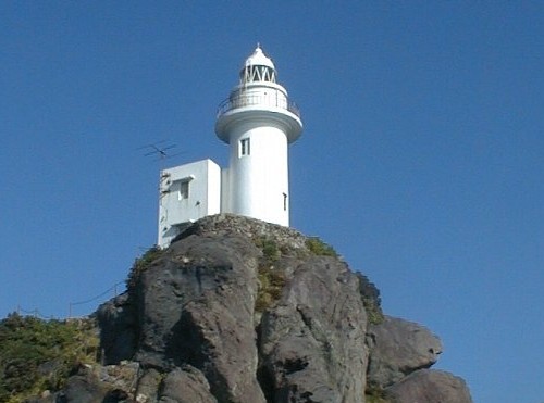
Date unknown. Active; focal plane 70 m (230 ft); white flash every 10 s. 13 m (43 ft) round concrete tower with lantern and gallery, attached to a 2-story concrete keeper's cottage. Entire lighthouse is white. A Coast Guard photo is at right, a 2023 closeup photo is available, Masahiro Daishi has a distant view, and Google has a satellite view. This lighthouse is perched on a steep pinnacle of rock that emerges from the sea at the north end of the Gotō chain. Accessible only by boat, and landing does not look easy. Site and tower closed. . ARLHS JPN-808; JCG-6101; Admiralty M5018; NGA 12720.
* Tsushimase (Tushimase) Hana
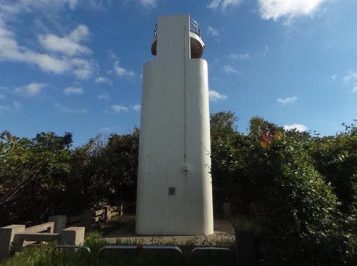
1978. Active; focal plane 29 m (95 ft); white light, 4 s on, 4 s off. 12 m (39 ft) round concrete tower with double gallery; also a continuous white spotlight (JCG-6103) illuminates a daybeacon on a nearby reef. Entire lighthouse is white. A page for the lighthouse has good photos, Higaki Toku has another photo, Yasunaga Mitsuharu has a closeup street view, and Google has a satellite view. Located at the northernmost point of Uku Shima. Accessible by road. Site open, tower closed. . ARLHS JPN-833; JCG-6102; Admiralty M5017.8; NGA 12716.
* Hizen Nagasaki Hana
Date unknown. Active; focal plane 10 m (33 ft); white light occulting once every 4 s. 7.5 m (35 ft) round concrete tower with an off-center gallery. Entire lighthouse is white. Mitsuei Yasunaga has a 2018 street view, Edge of Japan has a distant view, Jun Nishimura has a photo, and Bing has an indistinct satellite view. This is one of at least four Nagasaki Hana lights in Nagasaki Prefecture. Located in the surf at the easternmost point of Uku Shima. Accessible by road. Site open, tower closed. . ARLHS JPN-2232; JCG-6104; Admiralty M5017.7; NGA 12744.
Koshiki Shima Light
Koshiki Shima Light, Uku Shima
Japanese Coast Guard Sasebo Office photo
Kuromo (Kurobo) Se
Date unknown. Active; focal plane 21 m (69 ft); white flash every 3 s. 7.5 m (25 ft) round concrete tower centered on a 1-story concrete equipment shelter. Entire lighthouse is white. N. Aoaki has a 2020 photo, Edge of Japan has a photo (sixth photo on the page) and a more distant view and Bing has a satellite view. Located on an isolated reef about 6.5 km (4 mi) southeast of Ukumachi, the port of Uku Shima. Accessible only by boat, but there's a good view from ferries between Sasebo and Ukumachi. Site open, tower closed. ARLHS JPN-2214; JCG-6105; Admiralty M5016; NGA 12724.
Taira Kō
Date unknown. Active; focal plane 12 m (39 ft); red flash every 3 s. 10 m (33 ft) round cylindrical concrete tower. Entire lighthouse is red. A photo (first photo of the blog entry) is available, Yasunaga Mitsuharu has a distant street view, and Google has a satellite view. Located at the end of the east breakwater of Taira harbor, on the east side of Uku Shima. Site status unknown, but the light is easily seen from ferries arriving from Sasebo. ARLHS JPN-2273; JCG-6106; Admiralty M5017.4; NGA 12748.
Taira Kō South Breakwater
Date unknown. Active; focal plane 15 m (49 ft); two red flashes every 6 s. 9.5 m (31 ft) concrete post centered on a square 1-story concrete equipment shelter. Entire lighthouse is red. Google has a satellite view. Located at the southwest end of detached breakwater at the entrance to Taira harbor. Accessible only by boat. Site status unknown. ARLHS JPN-2274; JCG-6106.1; Admiralty M5017.5; NGA 12750.
Ai Se
Date unknown. Active; focal plane 15 m (49 ft); white flash every 5 s. 9.5 m (31 ft) round conical concrete tower attached to a small equipment shelter. Entire lighthouse is white. FOAL has distant views (next to last row of photos) and Google has a satellite view. Located on a rocky reef about 3 km (2 mi) south of Konoura harbor. Accessible only by boat. Site status unknown. ARLHS JPN-2152; JCG-6110; Admiralty M5016.4; NGA 12740.
* Konoura Kō South Breakwater
Date unknown. Active; focal plane 11 m (36 ft); red flash every 3 s. 8 m (26 ft) concrete post centered on a square 1-story concrete equipment shelter. Entire lighthouse is red. A 2021 photo is available and Google has a satellite view. Located at the end of the south breakwater of Konoura harbor. Accessible by walking the pier. Site status unknown. JCG-6107; Admiralty M5017.2; NGA 12756.

Ojika Town Lighthouses

Ojika occupies a group of small islands about 5 km (3 mi) south of Uku Shima. With a population of about 2600 it continues as an independent town.

Fuefuki Kō
Date unknown. Active; focal plane 14 m (46 ft); green light, 3 s on, 3 s off. 9 m (30 ft) concrete post attached to a square 1-story concrete equipment room. Entire lighthouse is white. FOAL has distant photos (bottom of the page) and Google has a satellite view and a distant street view. Located on the southernmost breakwater of Ojika harbor, on the south side of the island; the breakwater extends from Kuroshima, a small island that shelters the harbor. Site open, tower closed. ARLHS JPN-2246; JCG-6112; Admiralty M5022; NGA 12732.
#Ojika Kō
Date unknown. Inactive since 2015 and removed in 2016. This was a 9.5 m (31 ft) concrete post attached to a square 1-story concrete equipment room. Entire lighthouse was white. No photo available. Google's satellite view confirms the removal of the lighthouse. Located on the detached southwest breakwater of Ojika harbor. Accessible only by boat. Site open, tower closed. ex-JCG-6113; ex-Admiralty M5021; ex-NGA 12730.
Gotō Kuro Se
Date unknown. Active; focal plane 11 m (36 ft); white flash every 3 s. 7 m (23 ft) concrete post attached to a square 1-story concrete equipment room. Entire lighthouse is white. A photo and a second photo (2/3 the way down the page) are available, Hiroshi Matsuzaki has a photo showing the upper part of the light, and Bing has an indistinct satellite view. Located on an isolated rock about 8 km (5 mi) southwest of Ojika Shima. Accessible only by boat. Site status unknown. JCG-6115.6; Admiralty M5025.5; NGA 12729.
Shiro Se (2?)
Date unknown. Active; focal plane 38 m (125 ft); flash every 4 s, white or red depending on direction. 8 m (26 ft) round concrete tower with lantern. Entire lighthouse is white. A Coast Guard photo is at right and Bing has a fuzzy satellite view. NGA describes the tower as square. Located on an isolated rock about 25 km (15 mi) west of Ojika Shima. Accessible only by boat. Site status unknown. ARLHS JPN-2265; JCG-6115; Admiralty M5026; NGA 12764.
* Madara Shima (2?)
Date unknown. Active; focal plane 19 m (62 ft); white light occulting twice every 12 s. 10 m (33 ft) square 2-stage concrete tower. Entire lighthouse is white. Edge of Japan has a photo (second photo on the page), Jun Nishimura has a photo and a street view, and Google has a satellite view. Located at the northwestern point of Madara Shima, a smaller island off the west coast of Ojika Shima; accessible by bridge from Ojika Shima. Site open, tower closed. . ARLHS JPN-2217; JCG-6114; Admiralty M5020; NGA 12760.

Shiro Se Light, Ojika
Japanese Coast Guard Sasebo Office photo

Shin-Kamigotō Town Lighthouses

Shin-Kamigotō ("New Kamigoto") occupies the main island of Nakadōri and the smaller island of Wakamatsu, which are connected by a bridge. The town has a population of about 20,000.

Nakadōri Shima East Coast Lighthouses
* Tsuwa (Tuwa) Saki
Date unknown. Active; focal plane 119 m (390 ft); continuous white light with a more intense flash every 5 s. 9 m (30 ft) round concrete tower rising from a square 1-story concrete equipment room. Entire lighthouse is white. A closeup photo is at the top of this page, FOAL has a page with several photos, another photo and a 2021 closeup are available, Edge of Japan has a photo (second photo on the page), and Google has a satellite view. Located at the end of the long northern peninsula of Nakadōri Shima. Accessible by road and a short hike; parking provided. Site open, tower closed. . ARLHS JPN-834; JCG-6117; Admiralty M5025; NGA 12728.
Mamako Se
Date unknown. Active; focal plane 17 m (56 ft); white flash every 3 s. 9 m (30 ft) round concrete tower with a flared top, attached to a small equipment shelter. Entire lighthouse is white. Edge of Japan has a photo (third photo on the page) and Google has a satellite view. Located on a reef in the entrance to Arikawa harbor, on the northeast coast of Nakadōri Shima. Accessible only by boat. Site open, tower closed. ARLHS JPN-2219; JCG-6120; Admiralty M5015; NGA 12772.
Hirakushi Saki
Date unknown. Active; focal plane 36 m (118 ft); white flash every 5 s. 9.5 m (31 ft) square cylindrical concrete tower with gallery. Entire lighthouse is white. Don Masuta's street view is at right, Edge of Japan has a photo (fourth photo on the page), Don Masuta has a 2018 street view, and Google has a satellite view. Located on a promontory on the northeast coast of Nakadōri Shima, near Arikawa. Site status unknown. ARLHS JPN-124; JCG-6121; Admiralty M5014; NGA 12776.

Hirakushi Saki Light, Shin-Kamigotō, November 2018
Google Maps street view by Don Masuta
Hira Shima
Date unknown. Active; focal plane 53 m (174 ft); white flash every 4 s. 19 m (62 ft) round cylindrical concrete tower with lantern and gallery. Entire lighthouse is white. Edge of Japan has a closeup photo (1/5 the way down the page, #6122), and Google has a satellite view. Hira Shima is an island off the northeastern coast of Nakadōri Shima. Located at the western tip of Hira Shima, marking the strait between the two islands. Accessible only by boat. Site status unknown. ARLHS JPN-121; JCG-6122; Admiralty M5013; NGA 12780.
Hira Shima Kō Breakwater
Date unknown. Active; focal plane 17 m (56 ft); red flash every 3 s. 9 m (30 ft) concrete post attached to a square 1-story concrete equipment room. Entire lighthouse is red. Google has a satellite view. Located on the south breakwater of Hira Shima harbor. Probably accessible by walking the pier. Site open, tower closed. JCG-6123; Admiralty M5013.4; NGA 12784.
Aino Shima
Date unknown. Active; focal plane 25 m (82 ft); white flash every 5 s. 24 m (79 ft) round cylindrical concrete tower formerly with lantern and gallery. Entire lighthouse is white. Yu Sasaki's 2022 photo shows that the lantern has been removed. Edge of Japan has a distant photo (1/5 the way down the page, #6124), a view from the sea is available, FOAL has distant views (bottom of the page), and Google has a satellite view. Aino Shima is an island off the northeastern coast of Nakadōri Shima, about 10 km (6 mi) southwest of Hira Shima. Located at the western tip of Aino Shima, marking the strait between the two islands. Accessible only by boat. Site status unknown. ARLHS JPN-2153; JCG-6124; Admiralty M5011; NGA 12792.
Narao Kō North Breakwater
Date unknown. Active; focal plane 16 m (52 ft); red flash every 3 s. 9 m (30 ft) concrete post attached to a square 1-story concrete equipment room. Entire lighthouse is red. Google has a 2024 street view and a satellite view. NGA lists this light as "Ko-narao." Located on the north breakwater of Narao harbor, a ferry port near the southern tip of Nakadōri Shima. Site open, tower closed. ARLHS JPN-2237(=2210); JCG-6130; Admiralty M5010.35; NGA 12848.
Narao Kō South Breakwater
Date unknown. Active; focal plane 15 m (49 ft); green flash every 3 s. 10 m (33 ft) concrete post attached to a square 1-story concrete equipment room. Entire lighthouse is white. Google has a 2024 street view and a satellite view. In 2014 this light was relocated from the end of the south breakwater to a short detached breakwater added nearby; Google's 2011 street view shows the light at its original location. Note: NGA has the data and coordinates for this light confused with the south harbor south breakwater light (next entry). Located on the detached south breakwater of Narao harbor. Accessible only by boat. Site open, tower closed. ARLHS JPN-2238; JCG-6131; Admiralty M5010.3; NGA 12852.
Otona Se Light
Otona Se Light, Shin-Kamigotō
Japanese Coast Guard Nagasaki Office photo
* Narao Minami Kō (South Harbor) South Breakwater
Date unknown. Active; focal plane 15 m (49 ft); two green flashes every 6 s. 10 m (33 ft) concrete post attached to a square 1-story concrete equipment room. Entire lighthouse is white. Google has a satellite view and a 2011 street view that shows the top of the white lighthouse behind the smaller red north breakwater light. NGA lists this light as "Ko-naroa Ko Minami" and it has its data and coordinates confused with the north harbor south breakwater light. Located on the south breakwater of Narao harbor. Site open, tower closed. ARLHS JPN-2211; JCG-6133; Admiralty M5010.2; NGA 12844.
Otona Se
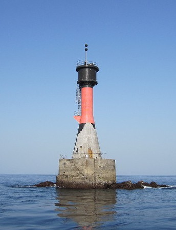
1951. Active; focal plane 20 m (66 ft); two white flashes every 5 s. 16 m (52 ft) round tapered concrete tower, painted black with a red horizontal band and mounted on a round concrete pier. The Coast Guard photo is above right and FOAL has several photos but the lighthouse is not shown in Google's satellite view. Located on a reef about 2.5 km (1.5 mi) east of Sao Saki. Accessible only by boat. Site open, tower closed. JCG-6129; Admiralty M5010; NGA 12860.
Gotō Sao Saki
1973. Active; focal plane 22 m (72 ft); white flash every 3 s. 12 m (39 ft) concrete post attached to a 1-story concrete equipment shelter. Entire lighthouse is white. The Coast Guard photo is at right, FOAL's page has photos, a distant 2023 view from the sea is available, and Google has a satellite view. Located at the southern tip of Nakadōri Shima. Accessible only by boat. Site status unknown. ARLHS JPN-073; JCG-6134; Admiralty M5009.6; NGA 12836.

Wakamatsu Shima Lighthouse
Arifuku (Arihuku) Shima (Fukushima)
1972. Active; focal plane 20 m (66 ft); white flash every 3 s. 10 m (33 ft) concrete post attached to a 1-story concrete equipment shelter. Entire lighthouse is white. Google has an indistinct satellite view. Arifuku Shima is a small island, accessible by bridge, off the western end of Wakamatsu Shima, which is in turn off the southwestern end of Nakadōri Shima. Located on the western tip of the island. Site open, tower closed. ARLHS JPN-2158; JCG-6175; Admiralty M5028.4; NGA 12828.
Gotō Sao Saki
Gotō Sao Saki Light, Shin-Kamigotō
Japanese Coast Guard Nagasaki Office photo

Nakadōri Shima West Coast Lighthouses
Kushi Shima (Kusi Sima)
1952. Active; focal plane 114 m (374 ft); white flash every 4 s. 11 m (36 ft) round concrete tower rising from a square 1-story concrete equipment room. Entire lighthouse is white. A 2023 photo is available and Google has a satellite view. Located on a small island off the westernmost point of Nakadōri Shima. Accessible only by boat. Site status unknown. ARLHS JPN-314; JCG-6176; Admiralty M5028; NGA 12824.
Ichino (Itino) Se (Aokata Kō, Aokata Wan)
1963. Active; focal plane 14 m (46 ft); one short and one long green flash every 8 s. 11 m (36 ft) round tapered concrete tower with an expanded top section, painted green. FOAL's page has photos, a 2023 photo is available, and Google has an indistinct satellite view. Located on a reef in the entrance to Aokata, on the west coast of Nakadōri Shima. Accessible only by boat. Site open, tower closed. ARLHS JPN-2156; JCG-6178; Admiralty M5027.4; NGA 12816.
Yagatomeno Hana (Yakatame Saki)
1954. Active; focal plane 40 m (131 ft); white light, 4 s on, 4 s off. 11 m (36 ft) round concrete tower attached to a 1-story concrete equipment shelter. Entire lighthouse is white. Shinichi Sakakibara's 2023 photo is at right, the Coast Guard has a photo, Edge of Japan has a photo (first photo on the page), FOAL has a page with several photos, and Google has a satellite view. Located on a promontory on the northwest coast of Nakadōri Shima. Accessible by a well marked hiking trail. Site status unknown. ARLHS JPN-746; JCG-6179; Admiralty M5027; NGA 12812.
Tsuboga (Tuboga) Se
1969. Active; focal plane 17 m (56 ft); two white flashes every 5 s. 14 m (46 ft) round tapered concrete tower with an expanded top section, painted black with a red horizontal band. FOAL has two photos (bottom of the page) and Bing has an indistinct satellite view. Located on a reef about 3 km (2 mi) off the northwest coast of Nakadōri Shima. Accessible only by boat. Site open, tower closed. JCG-6180; Admiralty M5026.6; NGA 12808.

Yagatomeno Hana Light, Shin-Kamigotō, November 2023
Google Maps photo by Shinichi Sakakibara

Gotō City (Southern Gotō Islands) Lighthouses

Gotō City includes the southwestern half of the Gotō archipelago including the main island of Fukue. The city's population is about 38,000.

Naru Shima Lighthouses
Takanō (Takanou) Hana
1964. Active; focal plane 22 m (72 ft); white light, 3 s on, 3 s off. 12 m (29 ft) concrete post attached to a 1-story concrete equipment shelter. Entire lighthouse is white. Kabas Taka has a photo and Google has a distant satellite view. Located at the tip of a promontory on the east side of an island southeast of Naru Shima. May be accessible only by boat. Site status unknown. ARLHS JPN-2277; JCG-6136; Admiralty M5008; NGA 12856.
* Narushima (Narusima) Kō
1986. Active; focal plane 12 m (39 ft); white flash every 3 s. 9.5 m (31 ft) concrete post attached to a 1-story concrete equipment shelter. Entire lighthouse is white. FOAL has a page with photos and Google has a satellite view and a distant street view. Located at the end of the main (south) breakwater of Narushima harbor. Accessible by walking the pier. Site open, tower closed. JCG-6140.5; Admiralty M5008.45; NGA 12960.
Kakarisaki Hana (Kakarisaki Bana)
1976. Active; focal plane 21 m (69 ft); two green flashes every 6 s; also a continuous white spotlight (JCG-6143) illuminates a nearby reef.. 9.5 m (31 ft) round concrete tower. Entire lighthouse is white. Noriaki Hamamura's 2022 photo is at right, FOAL has a page with photos, Edge of Japan has a photo (4/5 the way down the page, #6142), a 2017 photo is available, and Google has a satellite view. Located on the tip of a promontory on the south side of Naru Shima, about 2.5 km (1.5 mi) west of Narushima harbor. Accessible only by boat. Site open, tower closed. . ARLHS JPN-2194; JCG-6142; Admiralty M5008.6; NGA 12956.
Kurose Hana
1976. Active; focal plane 18 m (59 ft); white flash every 5 s. 9.5 m (31 ft) concrete post attached to a 1-story concrete equipment shelter. Entire lighthouse is white. The Coast Guard has a photo, a 2014 photo is available, and Google has a satellite view. Located on a rock off the western tip of Naru Shima. Accessible only by boat. Site open, tower closed. ARLHS JPN-2215; JCG-6174; Admiralty M5028.6; NGA 12972.

Kakarisaki Hana Light, Gotō, May 2022
Google Maps photo by Noriaki Hamamura

Fukue Shima Lighthouses
Gotō (Fukue Kō) North Breakwater
2001. Active; focal plane 12 m (39 ft); two red flashes every 6 s. 9 m (30 ft) concrete post attached to a square 1-story concrete equipment shelter. Entire lighthouse is red. FOAL has photos, a 2023 view from the sea is available, Toshihiro Kasai has a distant street view across the harbor, and Google has a satellite view. Located at the east end of the detached north breakwater of Gotō harbor. Accessible only by boat. Site open, tower closed. ARLHS JPN-2169; JCG-6147; Admiralty M5006; NGA 12864.
* Saikai
About 1850. Inactive. Approx. 6 m (20 ft) square pyramidal unpainted stone tower with an open box lantern. A 2017 photo is available, Yuchi Kawasaki has a closeup, and Google has a street view and a satellite view. This is a rare surviving example of a traditional Japanese lighthouse. Located on a stone pier, connected to shore by a modern pier, in downtown Gotō. Site open, tower closed.
Gotō (Fukue Kō) South Breakwater
2001. Active; focal plane 14 m (46 ft); two green flashes every 6 s. 10 m (33 ft) concrete post attached to a round 1-story concrete equipment shelter. Entire lighthouse is white. FOAL has photos, Toshihiro Kasai has a very distant street view across the harbor, and Google has a satellite view. Located at the north end of the detached south (really east) breakwater of Gotō harbor. Accessible only by boat. Site open, tower closed. JCG-6148; Admiralty M5006.41; NGA 12868.
Sakiyama Kō (North Breakwater)
1973. Active; focal plane 13 m (43 ft); red flash every 3 s. 8.5 m (28 ft) concrete post attached to a square 1-story concrete equipment shelter. Entire lighthouse is red. FOAL has two photos, and Google has a satellite view. Located at the end of the detached north breakwater of Sakiyama, near the easternmost point of Fukue Shima. Accessible only by boat. Site open, tower closed. ARLHS JPN-2258; JCG-6150; Admiralty M5005.7; NGA 12876.
Ō Shima (Gotō Ōshima, Fukue Ōshima)
1934. Active; focal plane 103 m (338 ft); two white flashes every 20 s. 13 m (43 ft) square cylindrical concrete tower with lantern and gallery, attached to a 1-story concrete keeper's house. Entire lighthouse is white. Haruo Sugi's 2021 closeup photo is at right, the Coast Guard has a photo, Chie Ikeda has a 2022 photo, and Google has a satellite view. Ō Shima is an inhabited island about 2 km (1.2 mi) in length located about 10 km (6 mi) southeast of Fukue Shima. Located on the highest point of the island. Accessible only by boat. Site status unknown. . ARLHS JPN-447; JCG-6152; Admiralty M5003; NGA 12976.

Gotō Ō Shima Light, Gotō, September 2021
Google Maps photo by Haruo Sugi
Tomie Kō (Okinokuro Se)
Date unknown (station established 1927). Active; focal plane 11 m (36 ft); white flash every 5 s. 8.5 m (28 ft) concrete post attached to a square 1-story concrete equipment shelter. Entire lighthouse is white. FOAL has two photos, Jack Gizamimi has a 2023 photo, and Google has a satellite view. Located on a reef outside the harbor of Tomie, on the south coast of Fukue Shima. Accessible only by boat. Site status unknown. ARLHS JPN-2282; JCG-6154; Admiralty M5004; NGA 12880.
* Kasayama Saki
1966. Active; focal plane 19 m (62 ft); white flash every 6 s; also a continuous white spotlight (JCG-6158) illuminates a nearby reef. 11 m (36 ft) round concrete tower with a round enclosure for the spotlight at the top, attached to a square 1-story concrete equipment room. Entire lighthouse is white. A 2022 photo is at right, the Coast Guard has a photo, FOAL has a page with photos, Akihiko Sasaki has a 2020 photo, and Google has a closeup 2024 street view and an indistinct satellite view. Located at the southernmost point of Fukue Shima. Accessible by road. Site open, tower closed. . ARLHS JPN-2196; JCG-6157; Admiralty M5002.8; NGA 12892.
* Kurose Kō
Date unknown. Active; focal plane 15 m (49 ft); red flash every 3 s. 9.5 m (31 ft) concrete post attached to a square 1-story concrete equipment shelter. Entire lighthouse is red. Google has a satellite view and a distant street view. Located on the main breakwater of Kurose harbor, a small port on the south coast of Fukue Shima. Accessible by walking the pier. Site open, tower closed. ARLHS JPN-2216; JCG-6159; Admiralty M5002.6; NGA 12896.
* Daiho Kō
Date unknown. Active; focal plane 13 m (43 ft); green light, 3 s off, 3 s on. 10 m (33 ft) concrete post attached to a square 1-story concrete equipment shelter. Entire lighthouse is white. A closeup 2022 photo is available and Google has a 2024 street view and a satellite view. Located on the east breakwater of Daiho harbor, a small port on the southwest coast of Fukue Shima. Accessible by walking the pier. Site open, tower closed. ARLHS JPN-2166; JCG-6160; Admiralty M5002.5; NGA 12900.
 

Kasayama Saki Light, Gotō, February 2022
Instagram photo by
* Ōse (Ohse) Saki (2)
1971 (station established 1881). Active; focal plane 83 m (272 ft); white flash every 10 s. 16 m (52 ft) round cylindrical concrete tower with lantern and gallery. Entire lighthouse is white. A 2022 photo is at the top of this page, FOAL has a page with excellent photos, the Nagasaki Coast Guard Office has a page with a distant view, Kyohei Yamamoto has a 2021 photo, Hiroki Saito has a panoramic photo of the spectacular site, and Google has a street view and a satellite view. This historic light station stands at Japan's extreme southwest corner. The original lighthouse, a cast iron tower, was preserved and is on display at the Museum of Maritime Science (Fune-no-Kagakukan) in Tōkyō. Located on a rocky promontory at the southwestern tip of Fukue Shima, marking the end of the Gotō archipelago. Accessible by road and a hiking trail. Site open, tower closed. . ARLHS JPN-815; JCG-6161; Admiralty M5002; NGA 12904.
Tamanoura Groin
Date unknown. Active; focal plane 11 m (36 ft); continuous red light with a more intense flash every 5 s. 8.5 m (28 ft) round tapered concrete tower. Entire lighthouse is red. Google has a photo and a satellite view. Located on a groin protecting the narrow south entrance to Tamanoura. May be accessible only by boat. Site open, tower closed. ARLHS JPN-2279; JCG-6162; Admiralty M5034; NGA 12908.
Tamanoura (Kuro Se)
1961. Active; focal plane 34 m (112 ft); white flash every 3 s. 9 m (30 ft) round concrete tower attached to a square 1-story concrete equipment room. Entire lighthouse is white. Jack Gizamim's 2023 photo is at right, Coast Guard has a page with a photo, FOAL has distant views (bottom of the page), and Google has a satellite view. Located atop a large rock on the south side of the entrance to the harbor of Tamanoura, on the west coast of Fukue Shima. Accessible only by boat. Site and tower closed. ARLHS JPN-825; JCG-6163; Admiralty M5032; NGA 12912.
* Tamanoura (Arakawa) North Breakwater
1982. Active; focal plane 10 m (33 ft); green flash every 3 s. 9.5 m (31 ft) concrete post attached to a square 1-story concrete equipment room. Entire lighthouse is white. Jack Gizamim has a 2024 closeup photo, FOAL has a page with photos and Google has a satellite view and a very distant street view. Located at the end of the north (main) breakwater of Tamanoura's Arakawa harbor. Accessible by walking the pier. Site open, tower closed. ARLHS JPN-2278; JCG-6164; Admiralty M5033.5; NGA 12920.
Tamanoura (Arakawa) Kō
1970. Inactive since 2016 and probably removed. 8.5 m (28 ft) round hourglass-shaped concrete tower. Entire lighthouse is white. FOAL has a page with photos but trees hide the location of the light in Google's satellite view. Located on the hillside above the north (main) breakwater of Tamanoura's Arakawa harbor. Site status unknown. ARLHS JPN-623; ex-JCG-6165; ex-Admiralty M5033; NGA 12916.

Tamanoura (Kuro Se) Light, Gotō, October 2o23
Google Maps photo by Jack Gizamim
* Fukue (Miiraku) Nagasaki Hana
1977. Active; focal plane 22 m (72 ft); white light, 3 s on, 3 s off; there is also a continuous white spotlight (JCG-6167) illuminating a reef 520 m (1/3 mi) offshore. Approx. 18 m (59 ft) square cylindrical white concrete tower. Entire lighthouse is white. FOAL's page has good photos, Hirotaka Yamamoto has a 2021 photo, and Google has a street view and a satellite view. Located on a prominent cape on the northwestern coast of Fukue Shima. Accessible by road. Site open, tower closed. . ARLHS JPN-2233; JCG-6166; Admiralty M5029.8; NGA 12928.
* Kashiwa Saki
1956. Active; focal plane 24 m (79 ft); white flash every 3 s. 15 m (49 ft) round cylindrical concrete tower attached to a 1-story concrete equipment room. Entire lighthouse is white. Rene Carrara Shiguetaka's photo is at right, Yuji Sawai has a 2022 photo, FOAL's page has closeup photos, and Google has a street view and a satellite view. Located on the northwestern tip of Fukue Shima. Accessible by road; parking provided. Site open, tower closed. . ARLHS JPN-2198; JCG-6168; Admiralty M5030; NGA 12924.
Miiraku Kō
Date unknown. Active; focal plane 13 m (43 ft); continuous red light with a more intense flash every 3 s. 9.5 m (31 ft) round cylindrical concrete tower attached to a small equipment shelter. Entire lighthouse is red. Google has a satellite view and a very distant street view. Located on the north breakwater of Miiraku harbor, a sheltered bay on the north coast of Fukue Shima. Site status unknown. ARLHS JPN-2225; JCG-6169; Admiralty M5029.6; NGA 12932.
Tateko Shima
1971. Active; focal plane 38 m (125 ft); white flash every 4 s. 8.5 m (28 ft) concrete post attached to a square 1-story concrete equipment room. Entire lighthouse is white. FOAL has a page with a closeup photo, Tomokazu Yasuda has a distant view, and Google has a satellite view. NGA and ARLHS misspell the name of the island as Taketo Shima. Located on an island off the western harbor of Kishiku, on the northwest coast of Fukue Shima. Accessible only by boat. Site status unknown. ARLHS JPN-631; JCG-6170; Admiralty M5029.4; NGA 12936.
 

Kashiwa Saki Light, Gotō, August 2017
Google Maps photo by Rene Carrara Shiguetaka
 
Itokushi Hana (Itokusi Saki)
1958. Active; focal plane 107 m (351 ft); white light occulting twice every 12 s; also a continuous white spotlight (JCG-6173.2) illuminates a nearby shoal. 9.5 m (31 ft) round concrete tower with a square, box-like lantern. Entire lighthouse is white. FOAL's page has closeup photos, Yoichi Shiraishi has a closeup, and Google has a satellite view. Located on the northern tip of Fukue Shima. Site status unknown. ARLHS JPN-186; JCG-6173; Admiralty M5029; NGA 12948.

Danjo Islands Lighthouse
Meshima (Me Shima) (2)
1953 (station established 1927). Active; focal plane 119 m (390 ft); three white flashes every 40 s. 15 m (49 ft) octagonal cylindrical concrete tower with lantern and gallery, attached to a 1-story concrete keeper's house. Entire lighthouse is white. Chie Ikeda's 2023 photo is at right, the Coast Guard has a good photo, a 2019 photo is available, and Google has a satellite view. The original lighthouse was heavily damaged in World War II but the Fresnel lans and its rotating equipement were saved by being buried deep in the mountain nearby. The lighthouse was returned to service in 1948. In 2006 this was the last Japanese lighthouse to be automated; a blogger covered this event, with photos. Me Shima is the southernmost of the Danjo Islands, which are small, uninhabited and rugged islands in the East China Sea about 60 km (40 mi) south southeast of Fukue Shima. The islands are protected as a nature reserve but they are visited sometimes by ecotours. Located at the southern end of the island. Accessible only by boat or helicopter. Site status unknown. ARLHS JPN-336; JCG-6181; Admiralty M4998; NGA 12980.

Information available on lost lighthouses:

Notable faux lighthouses:


Meshima Light, Gotō, February 2023
Google Maps photo by Chie Ikeda

Adjoining pages: Northeast: Sasebo Area | East: Nagasaki Area

Return to the Lighthouse Directory index | Ratings key

Posted August 6, 2007. Checked and revised May 14, 2024. Lighthouses: 53. Site copyright 2024 Russ Rowlett and the University of North Carolina at Chapel Hill.