Lighthouses of Japan: Oki Islands

The nation of Japan, known in Japanese as Nihon or Nippon (日本), occupies an archipelago off the east coast of Asia. The four main islands are Hokkaidō in the north, Honshū (the largest) in the center, Shikoku in the south, and Kyūshū in the southwest. The country includes thousands of other islands of all sizes; among them the Ryūkyū (Nansei) Islands are a long chain extending to the southwest and including the large island of Okinawa, and the Nanpō Islands are another long chain extending south into the Pacific Ocean. Much of Japan is mountainous but the coastal regions are densely populated and urbanized; the country's population is about 126 million.

Japan is divided into 47 prefectures. This page lists lighthouses of the Oki Islands portion of Shimane Prefecture, which faces the Sea of Japan on the far southwestern coast of Honshū.

The Oki Islands are located 50-80 km (30-50 mi) north of Matsue, Shimane. The largest island, Dōgo, is roughly circular with a diameter of about 20 km (13 mi). The other three inhabited islands, Nishinoshima, Nakanoshima, and Chiburishima, are closely grouped to the southwest of Dōgo. Once a place of exile for deposed emperors, the islands are now a national park and a popular tourist destination. Okinoshima, the largest town in the islands, has regular air service from Ōsaka, and all four major islands of the group are accessible by ferry from Matsue. The islands are governed as a subprefecture of Shimane Prefecture. The permanent population is about 25,000.

In Japanese the word for a lighthouse is tōdai or toudai (灯台). The words saki and misaki are for capes and headlands, hana ("nose") is a promontory, hantō is a peninsula, shima (also spelled sima or jima) is an island, bae is a reef, iwa or shi is a rocky reef, amase or se is a shoal, wan is a bay, nada is a sound or basin, kaikyō is a strait, kawa is a river, and or minato is a harbor.

Lighthouses in Japan are operated and maintained by the Japanese Coast Guard's Maritime Safety Agency. The Oki Islands lights are maintained by the Coast Guard office at Sakai, located on the mainland in Tottori Prefecture.

A note on the Sea of Japan/East Sea controversy: The Directory takes no side in any international dispute; it makes use of the terminology, names, and spellings as they currently exist in each area covered. The sea between Japan and Korea is called the Sea of Japan on the pages for Japan and the East Sea on the pages for Korea.

ARLHS numbers are from the ARLHS World List of Lights. JCG numbers are the Japanese Coast Guard's light list numbers. Admiralty numbers are from volume M of the Admiralty List of Lights & Fog Signals. U.S. NGA List numbers are from Publication

General Sources
Lighthouses in Japan - Shimane
A comprehensive Japanese-language site.
Lighthouse Visit
Another comprehensive site for Japanese lighthouses.
Form of a Lighthouse - Shimane
Another site with many photos of Japanese lighthouses.
Misty's Japanese Lighthouse Tour - Shimane
Photos and a few notes for lighthouses in all parts of the country.
Online List of Lights - Japan
Photos by various photographers posted by Alexander Trabas.
Navionics Charts
Navigation chart for the islands.


Saigō Misaki Light, Dōgo, September 2014
Google Maps photo by Hiroyuki Watanabe

Chiburishima (Chibu Village) Lighthouses
* Chiburi (Tihuri) Shima
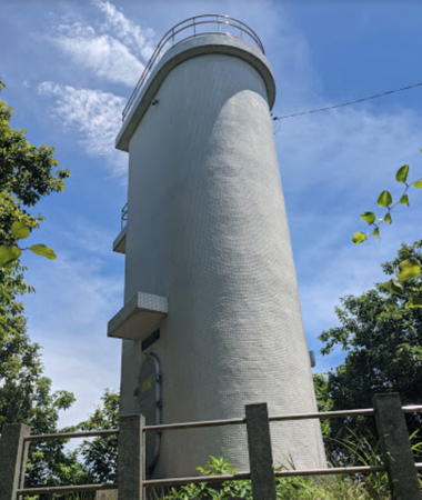
1953. Active; focal plane 158 m (518 ft); flash every 10 s, alternately red and white. 12 m (39 ft) round cylindrical concrete tower with lantern and gallery, rising from one end of a 1-story equipment building. Entire lighthouse is white. A 2019 photo (also seen at right), a 2020 photo, and a 2023 photo are available, Hideo Tomita has a closeup photo, Lighthouses in Japan has a very distant view and Google has a satellite view. This is the southernmost light of the islands. Located atop Mount Takabirayama, a heavily forested promontory at the southeastern corner of Chiburishima. Accessible by road. Site open, tower closed. ARLHS JPN-643; JCG-0851; Admiralty M7323; NGA 2092.
Chibu (Tibu) Kō
Date unknown. Active; focal plane 10 m (33 ft); one short and one long red flash every 9 s. 9 m (30 ft) concrete post attached to a square 1-story concrete equipment room. Entire lighthouse is red. Google has a street view and a satellite view. Located on a shoal on the east side of the entrance to Chibu harbor. Accessible only by boat. Site open, tower closed. JCG-0852; Admiralty M7323.2; NGA 2096.
* Mikoshi Hana (Mikoshibana)
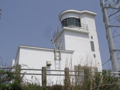
Date unknown. Active; focal plane 55 m (180 ft); continuous white light. Approx. 9 m (30 ft) semielliptical concrete tower with gallery; the light is shown through a window. Entire lighthouse is white. Naoki Saito has a 2023 photo, two additional photos (halfway down the page) are available and Google has a street view and a satellite view. This lighthouse shines a spotlight on a beacon on a nearby reef; Google also has a satellite view of the beacon. Located on a promontory about 3 km (1.8 mi) southwest of Chiburi harbor. Accessible by road. Site open, tower closed. JCG-0853; Admiralty M7323.22.

Chiburi Shima Light, Chiburi, November 2019
Google Maps photo by N T

Nishinoshima (Nishinoshima Town) Lighthouses
Nishinoshima has a very irregular shape, with two halves connected by a narrow isthmus at Uragō. A canal has been cut through the isthmus.
Akanada Hana
1958. Active; focal plane 22 m (72 ft); white flash every 4 s. 7 m (23 ft) round cylindrical concrete tower. Entire lighthouse is white. A 2019 closeup photo is available and Google has a closeup street view and satellite view. Located on the southernmost point of Nishinoshima, marking the narrow channel between that island and Chiburishima. Accessible only by boat. Site open, tower closed. ARLHS JPN-011; JCG-0856; Admiralty M7323.5; NGA 2104.
* Mitsabe (Mitabe) Misaki (2)
2023 (station established 1961). Active; focal plane 125 m (410 ft); white flash every 12 s. The original lighthouse was a 10 m (33 ft) 3-story rectangular cylindrical concrete tower with a semicircular lantern room and gallery on the top floor, attached to a 1-story concrete keeper's cottage. Entire lighthouse was white. A Coast Guard photo is at right, Lighthouse Visits has a page with a photo, Ryohsuke Torii has a very distant view, and Google has a satellite view. It appeasr that this lighthouse was removed in 2022 and a new structure is in place, but no photos of the new light are available. This is the westernmost light of the islands. Located at the end of a sharp wooded peninsula about 800 m (1/2 mi) west of the village of Mitsabe. Accessible by a hiking trail from the village. Site open, tower closed. ARLHS JPN-361; JCG-0858; Admiralty M7323.7; NGA 2112.
* Uragō Biden Kō
Date unknown. Active; focal plane 12 m (39 ft); red light, 3 s on, 1 s off. 9.5 m (31 ft) concrete post attached to a square 1-story concrete equipment room. Entire lighthouse is red. Google has a street view and a satellite view. Located at the end of the breakwater protecting the approach to the northern end of the canal at Uragō. Accessible by walking the pier. Site open, tower closed. JCG-0862; Admiralty M7323.4; NGA 2116.
Mitsabe Misaki Light
Mitsabe Misaki Light, Nishinoshima
Japanese Coast Guard photo
* Uragō Benten Kō
Date unknown. Active; focal plane 10 m (33 ft); continuous red light with a more intense flash every 5 s. 8.5 m (28 ft) concrete post attached to a square 1-story concrete equipment room. Entire lighthouse is red. Google has a street view and a satellite view. Located at the end of the east breakwater of Uragō's traditional harbor. Accessible by walking the pier. Site open, tower closed. JCG-0860; Admiralty M7323.36; NGA 2120.
Mugiyama Hana
Date unknown. Active; focal plane 38 m (125 ft); red flash every 3 s. 10 m (33 ft) round, hour-glass-shaped concrete tower with gallery. Entire lighthouse is red. Lighthouse Visit has a page for the lighthouse and Google has a satellite view. This lighthouses guides vessels into a bay on the south side of Nishinoshima leading to Uragō harbor. Located on a steep promontory on the east side of the entrance to the bay. Accessible only by boat. Site and tower closed. ARLHS JPN-377; JCG-0863; Admiralty M7323.6; NGA 2128.

Nakanoshima (Ama Town) Lighthouses
Matsuga Saki (Oki Matsuga Saki, Matuga Saki)
1975. Active; focal plane 13 m (43 ft); white flash every 3 s. 11 m (36 ft) round concrete tower with gallery, mounted on a square concrete pier. Entire lighthouse is white. Lighthouse Visits has a page for the lighthouse and Google has a satellite view. This lighthouse is at the northwestern point of Nakanoshima, marking a right-angle turn in the narrow channel between Nakanoshima and Nishinoshima. Located at the water's edge, at the extreme point of the cape. Accessible only by boat. Site and tower closed. ARLHS JPN-480; JCG-0864; Admiralty M7323.64; NGA 2144.
Kamo Shima
Date unknown. Active; focal plane 14 m (46 ft); two white lights every 5 s. 12 m (39 ft) round tower with gallery, painted black with one red horizontal band. Google has a satellite view. The area around this light features numerous rock formations looming above the water. Located on a reef off the north coast of Nakanoshima, guiding vessels in the strait separating Nakanoshima from Nishinoshima. Accessible only by boat. Site and tower closed. Admiralty M7321.77; JCG-0865; NGA 2148.
Komori Shima
1954. Active; focal plane 62 m (203 ft); three white flashes every 12 s. 7 m (23 ft) square cylindrical concrete tower, rising from one end of a 1-story concrete equipment house. Entire lighthouse is white. Saitō Tomosuke has a drone's-eye view, and Google has a satellite view. Located atop a huge rock about 1200 m (3/4 mi) off the northern tip of Nakanoshima, marking the northern entrance to the passage between Ama and Nishinoshima. Probably accessible only by helicopter. Site and tower closed. ARLHS JPN-285; JCG-0866; Admiralty M7321.7; NGA 2152.
Noda Saki
1976. Active; focal plane 80 m (262 ft); white flash every 5 s. 9.5 m (31 ft) semicircular cylindrical concrete tower. Entire lighthouse is white. Jun Katoh's photo is at right and Google has a satellite view. Located atop a promontory at the northeastern tip of Nakanoshima on the north side of the entrance to the harbor of Oki Toyoda. An unmarked trail leads to the lighthouse. Site open, tower closed. ARLHS JPN-425; JCG-0867; Admiralty M7321.74; NGA 2164.

Noda Saki Light, Nakanoshima, July 2021
Google Maps photo by Jun Katoh
* [Toyoda Kō]
Date unknown. Active; focal plane 16 m (52 ft); red flash every 3 s. 9.5 m (31 ft) post attached to a small 1-story equipment cabinet. Entire lighthouse is red. Jun Katoh has a 2021 photo and Google has a satellite view. Located at the end of the north (outer) breakwater of Toyoda, a port sheltered by Noda Saki. Accessible by walking the pier. Site open, tower closed. ARLHS JPN-1571; JCG-0869; Admiralty M7321.8; NGA 2166.
Chichii (Titii) Misaki
Date unknown. Active; focal plane 28 m (92 ft); three white flashes every 15 s. 10 m (33 ft) concrete tower, painted white with one red horizontal band. A view from the sea (fifth photo on the page) is available, and Google has a satellite view. Located at the easternmost point of Nakanoshima, which is at the end of a long, narrow peninsula. Accessible only by boat. Site and tower closed. ARLHS JPN-649; JCG-0870; Admiralty M7321.9; NGA 2160.
* Chichii Kō
Date unknown. Active; focal plane 11 m (36 ft); green flash every 4 s. 9.5 m (31 ft) concrete post attached to a square 1-story concrete equipment room. Entire lighthouse is white. Google has a street view and a satellite view. Located at the end of the south breakwater of Chichii harbor. Accessible by walking the pier. Site open, tower closed. JCG-0871; Admiralty M7321.94; NGA 2156.
Takada Hana (Takohana)
1950. Active; focal plane 105 m (346 ft); white flash every 3 s. 7 m (23 ft) round concrete tower, rising from one end of a 1-story concrete equipment house. Entire lighthouse is white. Google has a satellite view. Located atop a steep promontory at the southeastern point of Nakanoshima. Site status unknown; there is a trail about 1.5 km (0.9 mi) long leading to the lighthouse, but the trailhead is unmarked. ARLHS JPN-613; JCG-0872; Admiralty M7322; NGA 2136.
* Saki Kō
Date unknown. Active; focal plane 11 m (36 ft); continuous green light with a more intense flash every 5 s. 9.5 m (31 ft) concrete post attached to a square 1-story concrete equipment room. Entire lighthouse is white. Google has a satellite view and a distant street view. Located at the end of the south breakwater of Saki harbor. Accessible by walking the pier. Site open, tower closed. JCG-0873; Admiralty M7322.6; NGA 2132.
* Kiroga Saki
1974. Active; focal plane 41 m (134 ft); white flash every 5 s. 12 m (39 ft) round cylindrical concrete tower attached to a small concrete equipment shelter. Entire lighthouse is white. Takeshi Kegoya has a 2017 photo, a 2013 photo is available, Lighthouses in Japan has a view from the sea, and Google has a street view and a satellite view. Located on a promontory at the southernmost tip of Nakanoshima. Accessible by road. Site open, tower closed. . ARLHS JPN-261; JCG-0874; Admiralty M7322.8; NGA 2140.

Kiroga Saki Light, Nakanoshima, November 2013
Flickr photo by OK OKi

Dōgo Shima (Okinoshima Town) Lighthouses
Largest of the Oki Islands, Dōgo is roughly circular with a diameter of about 18 km (11 mi) and a population of about 15,000.

*
Saigō Misaki (Shiro Saki)
1921. Active; focal plane 109 m (358 ft); two white flashes every 30 s. 11 m (36 ft) square cylindrical concrete tower with lantern and gallery, centered on a 1-story concrete keeper's house. Entire lighthouse is white. Hiroyuki Watanabe's photo is at the top of this page, a 2022 closeup is available, Wakatomi Watanabe has a 2020 photo, Maki Matsumura has a 2016 photo, Lighthouse Visits has a page with photos, Shimane Prefecture also has a photo (near the bottom of the page), and Google has a satellite view. Prior to 1950 this was the only lighthouse in the Oki Islands. Located at the southeastern tip of Dōgo. Accessible by road and a short hike; parking is provided. Site open, tower closed. . ARLHS JPN-524; JCG-0893; Admiralty M7320; NGA 2064.
Shishiki (Shizika, Sizika, Shijika) Shima
1957. Active; focal plane 28 m (92 ft); white flash every 5 s. 13 m (43 ft) round concrete tower. Entire lighthouse is white. No closeup photo available but Google has a satellite view. Located on a small island just off the southwestern coast of Dōgo, directly opposite Nakanoshima. Accessible only by boat. Site and tower closed. ARLHS JPN-591; JCG-0875; Admiralty M7319.5; NGA 2076.
Tsuma (Tuma) Onbe Shima
1972. Active; focal plane 100 m (328 ft); continuous white spotlight. 6 m (20 ft) elliptical cylindrical concrete tower. Entire lighthouse is white. Lighthouse Visits has a page with a good photo, a 2022 closeup is available, and Google has a satellite view. Located on a headland north of the entrance to the harbor of Tsuma, a settlement on the southwest coast of Dōgo. Site status unknown. . JCG-0878; Admiralty M7321.44.
* Naku (Nagu) Saki
1963. Active; focal plane 46 m (151 ft); white flash every 5 s. 12 m (39 ft) round cylindrical concrete tower with lantern and gallery. Entire lighthouse is white. T. Kamioka has a closeup 2022 photo, a 2015 closeup is available, Lighthouse Visits has a page for the lighthouse, and Google has a street view (also seen at right) and a satellite view. Located on a promontory on the west coast of Dōgo, near the village of Naku. Accessible by road and a short hiking trail (described as a 10-minute walk); parking is provided at the trailhead. Site open, tower closed. . ARLHS JPN-401; JCG-0879; Admiralty M7321.4; NGA 2084.
* Mi Saki (Fukuura Saki)
1971. Active; focal plane 60 m (197 ft); white flash every 4 s. 10 m (33 ft) round hourglass-shaped concrete tower. Entire lighthouse is white. A 2017 photo and a panoramic view are available, Lighthouse Visits has a page for the lighthouse, and Google has a satellite view. Located on a promontory on the south side of the entrance to the harbor of Goka, on the northwest coast of Dōgo. Accessible by a hike of about 3 km (2 mi) round trip. Site open, tower closed. . ARLHS JPN-479; JCG-0880; Admiralty M7321.3; NGA 2088.

Naku Saki Light, Dōgo, May 2016
Google Maps street view by まちゃ_g
Okino Shima
1980. Active; focal plane 82 m (269 ft); white flash every 5 s. 13 m (43 ft) round concrete tower with gallery, attached to a 1-story concrete equipment house. Entire lighthouse is white. This light marks the northernmost point of the Oki Islands. Lighthouse Visits has a page for the lighthouse and Google has a satellite view. Toshiaki Yamaguchi has a view from near the Shiroshima Saki lighthouse (next entry) in which this light is barely visible atop the most distant island. Located on a small, steep island just off the north coast of Dōgo. Accessible only by boat. Site open, tower closed. ARLHS JPN-482; JCG-0881; Admiralty M7321.2; NGA 2032.
* Shiroshima Saki (Oki Syoto)
1956. Active; focal plane 258 m (846 ft); white flash every 15 s. 16 m (52 ft) round cylindrical concrete tower with lantern and gallery, rising from a 1-story concrete keeper's house. Entire lighthouse is white. A photo is at right, Katsuaki Nishimura has an excellent 2017 photo, M. Shigeki has another good photo, Kotsumi Chano has a 2023 photo, Lighthouse Visits has a page for the lighthouse, and Google has a satellite view. This powerful light, one of the highest lighthouses in Asia, has a range of 69.5 km (43 mi). The lighthouse was renovated in 1981, and the keeper's house was converted into a radio direction finding station. Located on a summit at the northern tip of Dōgo. Accessible by road and a hiking trail; parking is provided. Site open, tower closed. . ARLHS JPN-585; JCG-0882; Admiralty M7321.25; NGA 2036.
Nakamura Kō
Date unknown. Active; focal plane 15 m (49 ft); two red flashes every 6 s. 11 m (36 ft) round concrete tower with a flared top. Entire lighthouse is red. Hoihoi Takashi has a 2023 drone view and Google has a satellite view. Located on a detached breakwater at the entrance to Nakamura, a fishing harbor about 5 km (3 mi) southeast of Shiroshima Saki. Accessible only by boat. JCG-0883; Admiralty M7321.16; NGA 2040.
* Sakiyama Misaki
1967. Active; focal plane 94 m (308 ft); white light, 3 s on, 3 s off; also a continuous white spotlight (JCG-0885) illuminates a nearby reef. 10 m (33 ft) round hourglass-shaped concrete tower. Entire lighthouse is white. A distant view from the sea is available and Google has a satellite view. Located on a promontory at the entrance to the harbor of Fuse on the northeast coast of Dōgo. Accessible by a short hike from a nearby parking area. Site open, tower closed. ARLHS JPN-534; JCG-0884; Admiralty M7321.14; NGA 2044.
Shiroshima Saki Light
Shiroshima Saki Light, Dōgo, February 2011
ex-Panoramio photo copyright Hamtaro (ハム太郎); permission requested
Kuroshima Saki
1961. Active; focal plane 30 m (98 ft); three white flashes every 13 s; a continuous white spotlight (JCG-0887; added in 1987) is used illuminate Kabi Shima, a nearby skerry. 10 m (33 ft) round cylindrical concrete tower with a concrete lantern room at the top. Entire lighthouse is white. Hamtaro's photo is at right, Lighthouse Visits has a page with a photo, a distant view is available, and Google has a satellite view. Located on the easternmost point of Dōgo. Site status unknown. ARLHS JPN-310; JCG-0886; Admiralty M7321.1; NGA 2048.
Ikejiri (Ikeziri) Saki
1976. Active; focal plane 108 m (354 ft); white flash every 3 s. Approx. 9 m (30 ft) semicircular cylindrical white concrete tower attached to a small equipment shelter. Masaya Okada has a closeup photo and Google has a satellite view. Located atop a mountainous headland on the north side of the entrance to Saigō harbor, on the southeast side of the island. Site status unknown. ARLHS JPN-689; JCG-0888; Admiralty M7320.8; NGA 2052.
Hime Shima
Date unknown. Active; focal plane 12 m (39 ft); one short and one long red flash every 8 s. 11 m (36 ft) round concrete tower with double gallery and a strongly conical base, mounted on a concrete pier. Entire lighthouse is red. Google has a satellite view and a very distant street view. Located on the east side of the narrow entrance to Saigō harbor. Accessible only by boat; there's a good view from ferries arriving from the mainland. Site open, tower closed. ARLHS JPN-1573; JCG-0892; Admiralty M7320.2; NGA 2056.
Saigō Wan Breakwater East End
Date unknown. Active; focal plane 9.5 m (31 ft); green flash every 3 s. 8.5 m (28 ft) concrete post attached to a square 1-story concrete equipment shelter. Entire lighthouse is white. Eve Hiko has a 2018 photo and Google has a satellite view. Located at the northeast end of the detached breakwater of Saigō harbor. Accessible only by boat. Site open, tower closed. ARLHS JPN-523; JCG-0889; Admiralty M7320.4; NGA 2060.
Saigō Wan Breakwater West End
Date unknown. Active; focal plane 12 m (39 ft); three red flashes every 10 s. 10.5 m (34 ft) round cylindrical concrete tower. Entire lighthouse is red. Yasuo Baba has a view from shore and Google has street view and a satellite view. Located at the southwest end of the detached breakwater of Saigō harbor. Accessible only by boat. Site open, tower closed. JCG-0890; Admiralty M7320.5.

Kuroshima Saki Light, Dōgo, February 2011
ex-Panoramio photo copyright Hamtaro (ハム太郎); permission requested

Information available on lost lighthouses:

Notable faux lighthouses:

Adjoining page: South: Shimane

Return to the Lighthouse Directory index | Ratings key

Posted February 28, 2007. Checked and revised December 1, 2023. Lighthouses: 31. Site copyright 2023 Russ Rowlett and the University of North Carolina at Chapel Hill.