Lighthouses of Japan: Ōsumi and Tokara Islands

The nation of Japan, known in Japanese as Nihon or Nippon (日本), occupies an archipelago off the east coast of Asia. The four main islands are Hokkaidō in the north, Honshū (the largest), Shikoku in the south, and Kyūshū in the southwest. The country includes thousands of other islands of all sizes; among them the Ryūkyū (Nansei) Islands are a long chain extending to the southwest and including the large island of Okinawa, and the Nanpō Islands are another long chain extending south into the Pacific Ocean. Much of Japan is mountainous but the coastal regions are densely populated and urbanized; the country's population is about 126 million.

The Ōsumi and Tokara Islands, together with neighboring groups of smaller islands, form the northernmost quarter of the Nansei Islands (Nansei-shotō or "southwest islands" in Japanese). Unlike the rest of the archipelago the Ōsumi Islands were never part of the Ryukyu Kingdom; they have always been governed as part of Japan proper. Administratively the Ōsumi and Tokara Islands are part of Kagoshima Prefecture, the southernmost prefecture of Kyūshū.

At the end of World War II in 1945 the Ōsumi Islands remained under Japanese control while the Tokara Islands and the Ryūkyū Islands from the Tokara group southward came under U.S. military control. The U.S. returned control of the Tokaras to Japan in 1952.

In Japanese the word for a lighthouse is tōdai or toudai (灯台). The words saki and misaki are for capes and headlands, hana ("nose") is a promontory, hantō is a peninsula, shima (also spelled sima or jima) is an island, bae is a reef, iwa or shi is a rocky reef, amase or se is a shoal, wan is a bay, nada is a sound or basin, kaikyō is a strait, kawa is a river, and or minato is a harbor.

Lighthouses in Japan are operated and maintained by the Japanese Coast Guard's Maritime Safety Agency. Lighthouses in the Ōsumi islands are maintained by the Coast Guard office at Kagoshima City, Kyūshū.

ARLHS numbers are from the ARLHS World List of Lights. JCG numbers are the Japanese Coast Guard's light list numbers. Admiralty numbers are from volume M of the Admiralty List of Lights & Fog Signals. U.S. NGA List numbers are from Publication 112.

General Sources
Lighthouses in Japan - Kagoshima
This site has photos and data for most of the major lighthouses of Japan.
Region Ten Lighthouses
Information and photos posted by the Tenth Coast Guard Region office, which is responsible for Kagoshima Prefecture.
Lighthouses in Kagoshima Prefecture
Photos by various photographers available from Wikimedia.
Online List of Lights - Nansei Shoto
Photos by various photographers posted by Alexander Trabas.
Navionics Charts
Navigation chart for the islands.


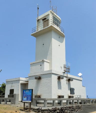
Kashika Saki Light, Nishioomote, May 2023
Google Maps photo by Satoshi Uesada
Mishima Islands Lighthouses
The Mishima Islands are small volcanic islands lying roughly in a west-to-east line northwest of the other Ōsumi Islands. Administratively the islands are organized as a village under the direct administration of Kagoshima City on the mainland of Kyūshū. The population is a little less than 400.
Kusagaki Shima
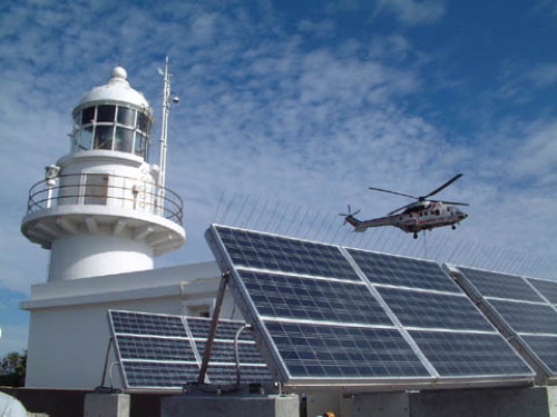
Date unknown. Active; focal plane 140 m (459 ft); two white flashes every 20 s. 14 m (46 ft) round cylindrical concrete tower with lantern and gallery, attached to an L-shaped 1-story concrete keeper's house. Entire lighthouse is white. A Coast Guard photo is at right and Google has a satellite view of the station. The light station has been converted to solar power and has the largest solar array of any Japanese lighthouse. Located atop an isolated and uninhabited island at the north end of a reef about 50 km (30 mi) west of Kuro Shima and 80 km (50 mi) southwest of Kyūshū. Accessible only by helicopter. Site and tower closed. ARLHS JPN-312; JCG-6901; Admiralty M4802; NGA 12988.
* Kuro Shima (Satsuma Kuroshima)
Date unknown. Active; focal plane 239 m (784 ft); flash every 5 s, alternately white and green. 11 m (36 ft) square cylindrical concrete tower with lantern and gallery. Entire lighthouse is white. Haruo Sugi has a 2021 closeup photo, another photo (fourth photo on the page) is available, and Google has a satellite view. Kuroshima is the westernmost of three inhabited islands of the Mishima group. The island has a permanent population of a little over 200; a ferry from Kagoshima city calls there two or three times per week. Accessible by road but no parking is provided. Located on heights at the eastern tip of the island. Site open, tower closed. JCG-6901.5; Admiralty M4804; NGA 12990.
* Iō Shima (Iōjima, Satsuma Ioshima)
1972. Active; focal plane 147 m (482 ft); white flash every 4 s. 13 m (43 ft) round concrete tower with gallery. Entire lighthouse is white. A 2023 photo and closeup are available and Google has a satellite view and a 2014 street view. The name transliterated here as Iō Shima (硫黄島) is the same name that is usually spelled in English as Iwo Jima, referring to a different island that was the site of a famous World War II battle. In both cases the Japanese name means "Sulphur Island." A ferry from Kagoshima city serves the island two or three times per week. Located on heights above the village of Iōjima at the western end of the island. Accessible by road but no parking is provided. Site open, tower closed. JCG-6902; Admiralty M4787; NGA 12992.
Kusagaki Shima Light
Kusagaki Shima Light, Mishima Islands
Japanese Coast Guard photo (no longer online)

Nishinoomote City (Northern Tanegashima) Lighthouses
Tanegashima, the northernmost of the major Nansei Islands, is about 58 km (36 mi) long but only about 10 km (6 mi) wide. The Portuguese adventurer Mindes Pinto arrived here in 1543. The island is best known today as the site of the Tanegashima Space Center, Japan's principal spaceport. Tanegashima is accessible by air and by high-speed ferry from Kagoshima. Locally the island is often called "Tane." Its population is about 35,000.

* Sumiyoshi (Sumiyosi) Misaki
1956. Active; focal plane 23 m (75 ft); white flash every 5 s. 10 m (33 ft) square cylindrical concrete tower rising from a square 1-story concrete equipment room. Entire lighthouse is white. A 2012 closeup photo is available, Taro Awakko has a 2020 photo, and Google has a street view and a satellite view. Located on a promontory on the central west coast of Tanegashima. Accessible by road. Site open, tower closed. JCG-6909; Admiralty M4794; NGA 13020.
Mageshima (Kamino Misaki)
Date unknown. Active; focal plane 14 m (46 ft); white flash every 3 s. 12 m (39 ft) round tapered white concrete tower attached to a small equipment shelter. A photo is available, Yuri Torii has a view from the sea, and Google has a satellite view. Mageshima is a small island about 13 km (8 mi) west of Nishinoomote. In 2009 the U.S. proposed to use the island for practice landings by carrier-based pilots. In 2019 the Japanese government purchased the island from its private owners for development as a base for both Japanese and U.S. training activities. Located on the northern tip of the island. Site and tower closed. ARLHS JPN-2573; JCG-6903; Admiralty M4791.4; NGA 12996.
Nishinoomote South Breakwater
Date unknown. Active; focal plane 14 m (46 ft); red flash every 3 s. 11 m (36 ft) round concrete tower with a flared top attached to a small equipment cabinet. Entire lighthouse is red. A closeup photo is at right, a view from the harbor is available, and Google has a satellite view and a very distant street view from the ferry pier. Located on the detached south breakwater of Nishinoomote. Accessible only by boat, but there is an excellent view from ferries arriving from Kagoshima. Site and tower closed. ARLHS JPN-2580; JCG-6908; Admiralty M4798.6; NGA 13016.

South Breakwater Light, Nishinoomote, October 2015
Google Maps photo by makkisse999
Nishinoomote (Nisinoomote)
1998. Active; focal plane 18 m (59 ft); two red flashes every 6 s. 15 m (49 ft) round cylindrical tower with lantern. The lighthouse is built in the form of Japanese H-2 rocket with two strap-on booster tubes on the sides. Entire lighthouse is red. Frank Zhang's 2023 photo is at right, a 2021 photo, a 2017 photo, and a 2006 photo are available, and Google has a satellite view and a very distant street view. Located at the north end of the detached outer breakwater of Nishinoomote, marking the entrance to the harbor. Accessible only by boat, but there is an excellent view from ferries arriving from Kagoshima. Site and tower closed. ARLHS JPN-2578; JCG-6904.1; Admiralty M4798.8; NGA 13002.
* Nishinoomote Sinko West Breakwater
1964. Inactive since 2015. 9.5 m (31 ft) concrete post attached to a square 1-story concrete equipment room. Entire lighthouse is white. A 2015 closeup photo and a 2014 view from the sea are available and Google has a satellite view and a very distant street view. Deactivated harbor lights are usually removed in Japan, but Yoshida Shinnaku's 2018 sunset photo and Fox Mulder's 2022 photo show that this one has remained. Located at the end of the breakwater in Nishinoomote harbor; the area north of the lighthouse has been reclaimed and developed as the Nippominato Park. Accessible by walking the pier. Site open, tower closed. ARLHS JPN-2581; ex-JCG-6908; ex-Admiralty M4798.4; ex-NGA 13012.
Nishinoomote Sunosaki (Sonosaki) Breakwater
1964. Active; focal plane 13 m (43 ft); continuous green light with a more intense flash every 6 s. 9.5 m (31 ft) concrete post attached to a square 1-story concrete equipment room. Entire lighthouse is white. A closeup photo is available and Google has a satellite view and a 2023 street view. Located at the end of a detached breakwater in Nishinoomote harbor. Accessible only by boat. Site open, tower closed. ARLHS JPN-2579; JCG-6905; Admiralty M4796; NGA 13004.
* Kashika (Kasika) Saki
1963. Active; focal plane 69 m (226 ft); red flash every 15 s. 13 m (43 ft) square cylindrical concrete tower with concrete equipment room and gallery, rising from a 1-story concrete equipment building. Entire lighthouse is white. Satoshi Uesada's photo is at the top of this page, a closeup 2017 photo and a 2015 photo are available, the Coast Guard has a 2005 photo, and Google has a closeup street view and a satellite view. Located on the northern tip of Tanegashima. Site open, tower closed. ARLHS JPN-773; JCG-6904; Admiralty M4799; NGA 13000.

Nishinoomote Light, Nishinoomote, March 2023
Gooogle Maps photo by Frank Zhang
#Shiojiura (Syoziura) Kō
Date unknown. Deactivated and removed in November 2013. This was an 8.5 m (28 ft) post attached to a square 1-story concrete equipment shelter. Google's satellite view and January 2014 street view confirm the removal of the light. Formerly located at the end of the south breakwater of Shiojiura harbor on the northeastern coast of Tanegashima. Site open. ARLHS JPN-2588; ex-JCG-6915; ex-Admiralty M4800; ex-NGA 13044.

Minamitane Town (Southern Tanegashima) Lighthouses
Kumano Kō Directional
Date unknown. Active; focal plane 28 m (95 ft); continuous white, red green light depending on direction. 7 m (23 ft) square white concrete tower. A 2012 photo is available and Google has a street view and a satellite view. Located on a rocky pinnacle about 800 m (1/2 mi) southwest of Kumano harbor. Site status unknown. JCG-6914; Admiralty M4800.6; NGA 13040.
Otake Saki (Tanegashima)
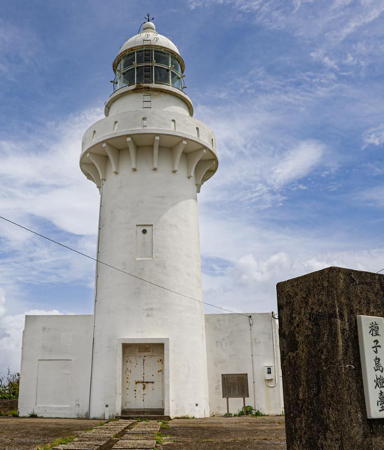
1951. Active; focal plane 106 m (348 ft); two white flashes every 20 s. 18 m (59 ft) round concrete tower with lantern and gallery, rising from a semicircular 1-story concrete keeper's cottage. Entire lighthouse is white. A 2021 photo is at right, a 2023 closeup and a 2010 closeup are available, Bill Ingalls has a 2014 photo, and Google has a street view and a satellite view. This is the oldest and most powerful lighthouse on the island, with a range of 48 km (30 mi). There are launch support facilities adjacent to the lighthouse, including a tall skeletal tower and a building that probably houses radar or cameras. Located on a steep bluff in Minamitane on the southeastern coast of Tanegashima. Site probably closed; it is accessible by road but the area is probably not open to the public. . ARLHS JPN-625; JCG-6912; Admiralty M4792; NGA 13032.
Shimana Saki
1968. Active; focal plane 17 m (56 ft); white light, 2 s on, 2 s off. 11.5 m (38 ft) concrete post rising from a square 1-story concrete equipment room. Entire lighthouse is white. The Coast Guard has a page with a photo, a 2023 photo is available, Shigekazu Yoshikawa has a closeup street view, and Google has a satellite view. This lighthouse marks the north entrance to the strait between Tanegashima and Yakushima. Located on a promontory in Minamitane on the southwest coast of Tanegashima. Site status unknown. . ARLHS JPN-561(=2586); JCG-6911; Admiralty M4793; NGA 13028.
Shimana Kō West Breakwater
Date unknown. Active; focal plane 16 m (52 ft); two red flashes every 6 s. 10 m (33 ft) concrete post attached to a square 1-story concrete equipment room. Entire lighthouse is red. A closeup photo is available and Google has a satellite view and a very distant street view across the harbor. In 2020 the light was relocated to the end of a new detached extension of the breakwater. Shimana is a terminal for ferries to Yakushima. Located at the northeast end of the detached west breakwater of Shimana. Accessible only by boat. Site open, tower closed. ARLHS JPN-2585; JCG-6910; Admiralty M4793.5; NGA 13024.

Otake Saki (Tanegashima) Light, Minamitane, April 2021
Instagram photo by hana_88_1022

Yakushima Town Lighthouses
Yakushima is a roughly circular island about 15 km (9 mi) in diameter, separated from Tanegashima by the 16 km (10 mi) wide Yakushima Strait. The mountains of Yakushima have the highest rainfall in Japan and are cloaked with a unique forest recognized as a World Heritage Site. The island has a population of about 15,000 and is accessible by air or ferry from Kagoshima; there are also ferries from Nishioomote and Shimana on Tanegashima.
* Nagota Misaki (Yakushima)
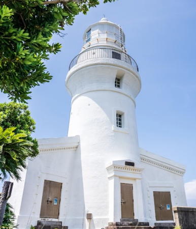
1897. Active; focal plane 72 m (236 ft); white flash every 15 s. 20 m (66 ft) round brick tower with lantern and gallery, rising from a semicircular 1-story keeper's cottage. Entire lighthouse painted white. A 2022 photo is at right, Felix Chao has a 2017 photo, the Coast Guard has a page for the lighthouse, a good 2007 photo is also available, Tadahiro Okuda has a closeup, Chie Ikeda has a 2021 photo, a 2022 photo is available, and Google has a street view and a satellite view of the station. This historic lighthouse, the oldest in the Nansei Islands, was long known as Yakushima Light since it was the only lighthouse on the island. Located on the northwestern tip of Yakushima. Accessible by road. Site open, tower closed. . ARLHS JPN-747; JCG-6923; Admiralty M4788; NGA 13072.
* Issō Kō
Date unknown. Active; focal plane 14 m (46 ft); continuous red light with a more intense flash every 6 s. 10 m (33 ft) concrete post attached to a square 1-story concrete equipment room. Entire lighthouse is red. Google has a street view and a satellite view. Located at the end of the north (main) breakwater of Issō, at the northern tip of Yakushima. Accessible by walking the pier. Site open, tower closed. JCG-6922; Admiralty M4790.4; NGA 13068.
* Yahazu Saki (Issō)
1961. Active; focal plane 44 m (144 ft); white flash every 10 s. 11 m (36 ft) square cylindrical concrete tower with lantern and gallery. Entire lighthouse is white. Gary Walker has a 2022 photo, the Coast Guard has a page for the lighthouse, a 2021 closeup photo and another photo are available, and Google has a satellite view. Located at the end of a narrow peninsula at the northern tip of Yakushima, marking the entrance to the harbor of Issō. Accessible by a 10-minute walk from the end of the public road. Site open, tower closed. . ARLHS JPN-2594; JCG-6921; Admiralty M4790; NGA 13064.
Miyanoura Kō
2009. Active; focal plane 15 m (49 ft); two red flashes every 7 s. 11 m (36 ft) round concrete tower with a flared top, attached to a small equipment shelter. Entire lighthouse is red. A 2022 photo is available, Shigeru Harazaki has a distant street view, and Google has a satellite view. Located on a detached breakwater on the north side of the entrance to Miyanoura. Accessible only by boat, but there's a good view from ferries arriving from Tanegashima. Site open, tower closed. ARLHS JPN-2574; JCG-6920; Admiralty M4790.6; NGA 13060.
#Haya Saki
1972. Inactive since 2010 and later demolished. This was a 13 m (43 ft) round tapered concrete tower. Entire lighthouse is white. Fumio Tatsumi has a 2000 photo. Although the tower was removed the small lantern was saved and is mounted on a stone base; Google has a street view and a satellite view. Formerly located on the northeastern point of Yakushima, marking the passage through Yakushima Strait. Site open, tower closed. ARLHS JPN-748; ex-JCG-6919; ex-Admiralty M4790.8; ex-NGA 13056.

Nagota Misaki Light, Yakushima, August 2022
Google Maps photo by hormone29
Anbō Kō (Outer Breakwater)
Date unknown. Active; focal plane 14 m (46 ft); red flash every 4 s. 11 m (36 ft) round concrete tower attached to a square 1-story equipment shelter. Entire lighthouse is red. No closeup photo available but Google has a satellite view and a very distant street view. NGA misspells the name of the town as "Ambo." Located on an outer breakwater at Anbō, the principal port on the east coast of Yakushima. Accessible only by boat. Site open, tower closed. ARLHS JPN-2558; JCG-6918; Admiralty M4791; NGA 13052.
Tanisaki Hana (Onoaida)
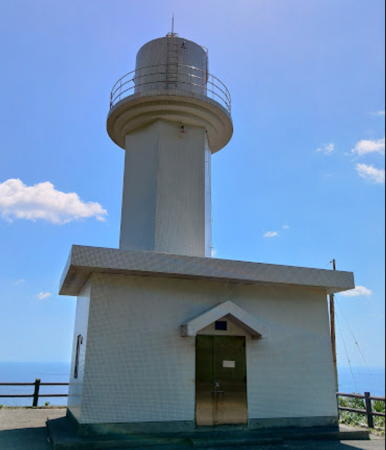
1973. Active; focal plane 51 m (167 ft); white flash every 5 s. 9.5 m (31 ft) hexagonal cylindrical concrete tower with gallery. Entire lighthouse is covered with tile, white with red trim. Otomo Yoshimi's 2023 photo is at right, Patricio Diaz has a 2018 closeup photo, another closeup photo and a third closeup are available, and Google has a distant satellite view. Located on a bluff near Yaku, on the south shore of Yakushima. Site open, tower closed. JCG-6917; Admiralty M4791.2; NGA 13048.

Kuchinoerabu Shima Lighthouses
Kuchinoerabu Shima (Kuchinoerabujima) is a smaller, actively volcanic island located about 12 km (7.5 mi) northwest of Yakushima. About 150 residents were evacuated in 2015 due to an eruption of Mount Shindake; another eruption in late 2018 and early 2019 did not require evacuations. The island is accessible by ferry from Issō, Yakushima.

Mega Saki
Date unknown. Active; focal plane 67 m (220 ft); two white flashes every 6 s. 10 m (33 ft) square cylindrical white concrete tower. A 2023 photo, a closeup (3/4 the way down the page), and a view from the sea (sixth photo on the page) are available, and Google has a satellite view. Located on the southeastern tip of Kuchinoerabu Shima. Site status unknown. ARLHS JPN-339; JCG-6924; Admiralty M4786.6; NGA 13084.
Kuchinoerabu Kō
Date unknown. Active; focal plane 13 m (43 ft); two red flashes every 7 s. 10 m (33 ft) round concrete tower with a flared top attached to a small equipment shelter. Entire lighthouse is red. A 2023 view from the sea and a commercial photo are available and Google has a satellite view. Located on a breakwater on the east side of the harbor of Kuchinoerabu, on the south side of the island. Site status unknown; there would be good views from arriving ferries. ARLHS JPN-2569; JCG-6925; Admiralty M4786; NGA 13080.
No Saki
Date unknown. Active; focal plane 92 m (302 ft); two white flashes every 14 s. 12 m (39 ft) square cylindrical concrete tower. Entire lighthouse is white. A closeup 2024 photo is available and Google has a satellite view. Located near the western tip of Kuchinoerabu Shima. Site status unknown. ARLHS JPN-398; JCG-6926; Admiralty M4786.3; NGA 13076.

Tanisaki Hana Light, Yakushima, June 2023
Google Maps photo by Otomo Yoshimi

Tokara Islands Lighthouses
The Tokara Islands (Tokara-rettō) are a group of small islands southwest of Yakushima. Kuchino Shima and Nakano Shima, near the northern end of the group, and Akuseki Shima and Takara Shima, at the southern end, are the inhabited islands. Administratively the islands are organized as the village of Toshima under the direct administration of Kagoshima City on the mainland of Kyūshū. The population of the village is about 700.

Ōsumi Hira Se
1974. Active; focal plane 33 m (108 ft); white flash every 3 s. 10 m (33 ft) round cylindrical white concrete tower with gallery. No photo available and the islet does not appear in Google's satellite view. Located atop a tiny island about 25 km (15 mi) northeast of Kuchino Shima, the northernmost of the main Tokara islands. Accessible only by boat. Site status unknown. ARLHS JPN-2583; JCG-6927; Admiralty M4785; NGA 13088.
Kuchino Shima (Kuti-no-Sima)
Date unknown. Active; focal plane 17 m (56 ft); red light, 3 s on, 3 s off. 9.5 m (31 ft) round concrete tower attached to a square 1-story equipment shelter. Entire lighthouse is red. Yasuhiko Nagata has a photo, a 2019 closeup is available, and Google has a fuzzy satellite view. Located on the south breakwater of Kuchino Shima's harbor. Accessible by walking the pier. Site open, tower closed. ARLHS JPN-2610; JCG-6927.5; Admiralty M4784.5; NGA 13092.
* Nakano Shima
Date unknown. Active; focal plane 63 m (207 ft); three white flashes every 20 s. 17 m (56 ft) square cylindrical concrete tower with lantern and gallery, attached to a 1-story concrete keeper's house. Entire lighthouse is white. Taro Nagoya's photo is at right, Masao Kikuchi has a view from the sea, and Google has a satellite view and a very distant street view. Located at the southeastern tip of the island. Accessible by road from Toshima, the one settlement, but the entrance to the light station is unmarked. Site open, tower closed. ARLHS JPN-422; JCG-6928; Admiralty M4783; NGA 13096.
Gaja (Gayza) Shima
Date unknown. Active; focal plane 207 m (679 ft); white flash every 15 s. 13 m (43 ft) round concrete tower with lantern and gallery rising from a 1-story service building. Entire lighthouse is white. The Coast Guard has a 2010 photo and Google has a satellite view. Gaja Shima is an isolated high island about 27 km (17 mi) west of Nakano Shima. Located on or near the northwestern point of the island. Site status unknown. ARLHS JPN-2560; JCG-6929; Admiralty M4784; NGA 13100.

Nakano Shima Light, Toshima, May 2007
Wikimedia Creative Commons photo by Taro Nagoya

Akuseki Shima
2003. Active; focal plane 158 m (518 ft); flash every 8 s, alternately green and white. 15 m (49 ft) octagonal cylindrical concrete tower with lantern and gallery, attached to a 1-story concrete equipment room. Entire lighthouse is white. A closeup 2023 photo is at right and Google has a satellite view. Located on the east side of Akuseki Shima, an island about 50 km (30 mi) south southwest of Nakano Shima. Accessible by road. Site open, tower closed. ARLHS JPN-2557; JCG-6929.5; Admiralty M4782.95; NGA 13102.
Maegomori Kō
Date unknown. Active; focal plane 16 m (52 ft); green flash every 3 s. 9 m (30 ft) round white concrete tower with a flared top, attached to a small equipment shelter. Jun Nishimura has a very distant view and Google has a distant satellite view. Located at the north end of the detached breakwater of Maegomori, on the north coast of Takara Shima. Accessible only by boat. Site open, tower closed. JCG-6930; Admiralty M4782.9; NGA 13108.
Takara Shima (Araki Saki)
Date unknown. Active; focal plane 72 m (236 ft); white flash every 10 s. 16 m (52 ft) square concrete tower with lantern and gallery. Entire lighthouse is white. Jun Nishimura has a 2015 photo, Saiko Zamami has a 2013 photo and a distant view, a 2022 closeup is available, and Google has a good satellite view. Located at the southeastern tip of Takara Shima. Accessible by road. Site status unknown. ARLHS JPN-618; JCG-6931; Admiralty M4782.8; NGA 13104.

Information available on lost lighthouses:

Notable faux lighthouses:


Akuseki Shima Light, Toshima, May 2023
Google Maps photo by Kabosu

Adjoining pages: North: Kagoshima Area | South: Amami Islands

Return to the Lighthouse Directory index | Ratings key

Posted August 27, 2007. Checked and revised June 29, 2024. Lighthouses: 32. Site copyright 2024 Russ Rowlett and the University of North Carolina at Chapel Hill.