Lighthouses of Russia: Kaliningrad

At the end of World War II the Potsdam Agreement of 1945 partitioned the German province of East Prussia, assigning the southern portion to Poland and the northern portion to the Soviet Union. The Soviets added the Klaipėda Region (the northernmost part of East Prussia) to the Lithuanian Soviet Republic and organized the rest of the territory as the Kaliningrad Oblast (province) of the Russian Federation, changing the name of the principal city from Königsberg to Kaliningrad. When the Soviet Union dissolved in 1991 Kaliningrad became a Russian exclave on the Baltic Sea, separated from the rest of Russia by the newly independent nations of Lithuania and Belarus.

Kaliningrad Oblast is one of the members, called federal subjects (sub'yekty federatsii), of the Russian Federation.

The Russian word for a lighthouse is mayak (маяк); ostrov is an island, kosa is a spit, rif is a reef, mys is a cape, bukhta is a bay, zaliv is a larger bay or gulf, ust'ye ("mouth") is an estuary, proliv is a strait, reka is a river, and gavan' is a harbor. The Baltic Sea is called the Baltiyskoye More in Russian.

Russian lighthouses are owned by the Russian Navy and maintained by the Office of Navigation and Oceanography (Управление навигации и океанографии).

Curly braces {} enclose the former German names of the light stations.

ARLHS numbers are from the ARLHS World List of Lights. Admiralty numbers are from volume C of the Admiralty List of Lights & Fog Signals. U.S. NGA List numbers are from Publication 116.

General Sources
Online List of Lights - Baltic Russia
Photos by various photographers posted by Alexander Trabas.
Leuchttürme an der russischen Küste
Photos and notes by Bernd Claußen.
Lighthouses in Kaliningrad Oblast
Photos by various photographers available from Wikimedia.
World of Lighthouses - Baltic Sea Russia
Photos by various photographers available from Lightphotos.net.
Leuchttürme der ehemaligen deutschen Ostgebiete
Postcard views of historical German lighthouses in Kaliningrad posted by Klaus Huelse.
Navionics Charts
Navigation chart for Kaliningrad.


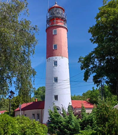
Baltiysk Range Rear Light, Baltiysk, July 2024
Instagram photo by Catherine Redfield

Vistula Spit Lighthouses (see also Poland: Baltic Coast)
The 65 km (40 mi) long Vistula Spit separates the Vistula Lagoon from the Baltic Sea. The base of the spit is in Poland, with the Russian border falling about halfway down its length. The first two lights mark this international border. They appear to be just inside Russia, but they may be maintained jointly by the two nations. In Russia the Vistula Spit is called the Baltiyskaya Kosa (Baltiysk Spit), and the Vistula Lagoon is called the Kaliningradskiy Zaliv (Kaliningrad Bay).
Boundary Range Front
Date unknown. Active; focal plane 26 m (85 ft); white flash every 5 s, synchronized with the rear light. 19 m (62 ft) rectangular cylindrical skeletal tower, painted black. The seaward side is supposed to carry a slatted daymark painted white with a red vertical stripe, but only a few unpainted slats remain. Trabas has a photo and Google has a satellite view and a distant street view from the beach in Poland. This light marks the westernmost point of Russia. The border is marked here only by the remains of a low fence and a stop sign. Located on dunes at the border. Site and tower closed. Admiralty C3095; NGA 7048.
Boundary Range Rear
Date unknown. Active; focal plane 44 m (144 ft); white flash every 5 s, synchronized with the front light. 22 m (72 ft) rectangular skeletal tower with gallery; the seaward side carries a slatted daymark painted black with a white vertical stripe. No photo available but Google has a satellite view. Located on the border, 578 m (0.36 mi) southeast of the front light. Site and tower closed. Admiralty C3095.1; NGA 7052.
* Shchukinskiy {Gross Brukh}
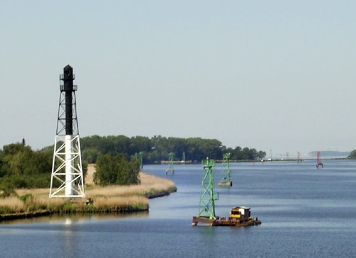
Date unknown. Active; focal plane 50 m (164 ft); white light, 1.5 s on, 2.5 s off. 29 m (92 ft) square skeletal tower. Two sides of the upper 2/3 of the tower are covered by a slatted daymark painted white below and black above. The daymark appears dilapidated in older photos but the lighthouse had been restored before the photo at right was taken in July 2011. The forest surrounds the tower in Google's satellite view. Located in the dunes about 10 km (6 mi) northeast of the border. Site open, tower closed. ARLHS KAL-007; Admiralty C3096; NGA 7056.

Baltiysk Lighthouses
Baltiysk, known as Pillau under German rule, is the principal port of Kaliningrad and an important base on the lower Baltic for the Russian Navy. The city straddles the Strait of Baltiysk (Pillauer Tief in German), the channel connecting the Baltic to the Vistula Lagoon, or Kaliningradskiy Zaliv. The strait was opened by a storm surge in 1497; since then it has been widened and deepened many times to allow for navigation by large ships.

*
[Baltiysk North Mole (2)]
Date unknown (station established 1884). Active; focal plane 13 m (43 ft); red flash every 3 s. 8 m (26 ft) post painted red with a white horizontal band. Ezhen Galkin has a photo, Trabas has a closeup, and Google has a street view and an indistinct satellite view. Lightphotos.net has a historic photo of the original lighthouse, which was probably destroyed in World War II. Located at the end of the north breakwater at the entrance to Baltiysk and the Vistula Lagoon. Accessible by walking the mole. Site open, tower closed. Admiralty C3100.11.

Shchukinskiy Light, Vistula Spit, July 2011
ex-Panoramio Creative Commons photo by Nirron
* [Baltiysk South Mole (2)]
Date unknown (station established 1884). Active; focal plane 13 m (43 ft); green flash every 3 s. 8 m (26 ft) post painted green with a white horizontal band. Sergey Ku has a photo, Trabas has a closeup, Sergey Andreev has a 2021 photo, Alexander Slepov has a street view, and Google has an indistinct satellite view. Located at the end of the south breakwater at the entrance to Baltiysk and the Vistula Lagoon. Accessible by walking the mole. Site open, tower closed. Admiralty C3100.12.
* Baltiysk {Pillau} Range Front (2)
Date unknown. Active; focal plane 12 m (39 ft); white light, 9 s on, 3 s off. 21 m (69 ft) square cylindrical red skeletal tower. The front of the tower carries a trapezoidal slatted daymark, painted white with a black vertical stripe. The light is mounted below the top of the tower. Trabas has a photo, Claußen has a photo (fourth photo on the page), Ezhen Galkin has a photo, Daniil Skoblov has a street view from the rear, and Google has an indistinct satellite view. This is the approach range for the harbor entrance. The original front lighthouse was an 8 m (26 ft) cast iron tower. Located on the east side of the entrance channel, 770 m (0.48 mi) northwest of the rear light and adjacent to the historic Pillau fortress. Site probably open, tower closed. Admiralty C3100; NGA 7060.
* Baltiysk Range Rear {Pillau Oberfeuer} (2)
1813 (station established at least by 1741). Active; focal plane 30 m (98 ft); white light, 9 s on, 3 s off. 33 m (105 ft) round brick tower with lantern and double gallery. The upper half of the lighthouse, including the lantern, is painted red and the lower half white. Catherine Redfield's 2024 photo is at the top of this page, Ion Kalmych has a 2021 photo, Wikimedia has Georgiy Dolgopskiy's 2007 photo, Paul Philippov has a winter 2006 photo, Trabas has a great photo by Klaus Kern, Anton Chmelev has a good photo, Huelse has a historic postcard view, Anton Logachev has a 2015 street view, Lightphotos.net has a historic photo taken about 1935, and Google has a satellite view. Baltiysk, the former German seaport of Pillau, is now the westernmost city in Russia, and a statue of Tsar Peter the Great stands in front of the lighthouse. Lights are said to have been displayed here as early as 1562 and this 1813 lighthouse was originally built about 20 m (66 ft) high. In 1909 it was raised in height and a new, larger lantern was installed. Huelse has a postcard view showing the original height and lantern. Located in the waterfront area in downtown Baltiysk. Site open, tower closed. . ARLHS KAL-002; Admiralty C3100.1; NGA 7064.
#Baltiysk Oil Harbour Breakwater West End (Neftyanoy Gavanov-Zapadnyy Range Front) (1)
Date unknown. Replaced. This was a 13 m (43 ft) triangular skeletal tower, painted with red and white horizontal bands. Claußen has a 2009 photo (first photo on the page) and Lightphotos.net has a more distant view also taken in 2009. The former range was discontinued in 2009 and the light was replaced by a smaller beacon seen in Trabas's photo and Google's satellite view. Located at the end of a curving guidewall in Baltiysk harbor. Accessible only by boat. Site status unknown. Admiralty C3100.14.
* Baltiyskaya Kosa (Baltiyskoy Kosy) Range Rear
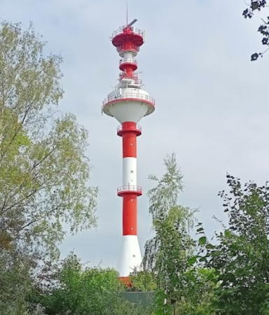
2009. Active; focal plane 61 m (200 ft); white light, 2 s on, 2 s off. 40 m (131 ft) round traffic control tower with multiple galleries, painted with red and white horizontal bands. Alexey Kopylov's 2021 photo is at right, Trabas has a photo by Werner Seiler, Mikhail Medvedev has a 2016 photo, Pavel Marchenko has a good 2010 photo, and Google has a satellite view. The range guides westbound vessels on the Kaliningrad Sea Canal. An April 2009 photo shows the lighthouse before it was painted and put into service. Located on the northeastern tip of the Curonian Spit opposite the west end of the canal. Site open, tower closed. Admiralty C3100.161.
 

Kosa Range Rear Light, Baltiysk, August 2021
Google Maps photo by Alexey Kopylov
 
Baltiyskaya Kosa (Baltiyskoy Kosy) Range Front
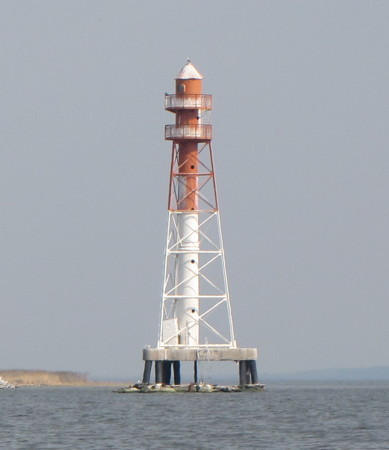
Date unknown. Active; focal plane 26 m (85 ft); white light, 2 s on, 2 s off. Approx. 24 m (79 ft) triangular pyramidal skeletal tower with central cylinder, lantern, and double gallery, mounted on a triangular concrete platform supported by piles. Upper half of the lighthouse painted red (formerly black), lower half white. Sergey Voronkov's photo is at right, he has a closeup on Lightphotos.net, Trabas has a photo, and Google has a satellite view. This lighthouse was formerly the rear light of the eastbound Neftyanoy Gavanov-Zapadnyy range; its upper half was then painted black. In 2009 that range was discontinued and the lighthouse became the front light of the new Baltiyskaya Kosa range. Claußen has a photo showing the older daymark. Located on a concrete pier near the southern entrance to the channel joining the Vistula Lagoon to the Baltic, about 800 m (1/2 mi) southeast of Baltiysk. Accessible only by boat. Site status unknown. Admiralty C3100.16.
Neftyanoy Gavanov-Vostochnyy Range Front
Date unknown. Active; focal plane 18 m (56 ft); green light, 2 s on, 2 s off. 18 m (56 ft) round cylindrical tower with gallery, painted black with a white vertical stripe. Trabas has a photo, Claußen has a photo (third photo on the page), Lightphotos.net has an aerial photo of the two range lights, and Google has a satellite view. This is the entrance channel range for the harbor. Located about 300 m (1000 ft) south of the Zapadnyy Range Rear light. Accessible only by boat. Site status unknown. Admiralty C3100.175.
Neftyanoy Gavanov-Vostochnyy Range Rear
Date unknown. Active; focal plane approx. 30 m (98 ft); green light, 2 s on, 2 s off. 30 m (98 ft) round cylindrical tower with gallery, painted black with a white vertical stripe. Trabas has a photo, Lightphotos.net has an aerial photo of the two range lights, and Google has a satellite view. Located about 450 m (1500 ft) southeast of the front light. Accessible only by boat. Site status unknown. Admiralty C3100.176.

Kaliningrad Sea Canal Lighthouses
Navigation of the shallow Vistula Lagoon is difficult for all but the smallest vessels. In 1901 Germany completed the Königsberg Ship Canal (now the Kaliningradskiy-Morskoi Canal), a dredged channel some 40 km (25 mi) long across the lagoon, allowing ships of moderate draft to access the city of Königsberg (now Kaliningrad). Dredge spoil islands line much of the channel. For navigators, the course of the canal is seen as a series of "gates" (vorot in Russian). Trabas has photos of all of the lights at the gates; we list only the larger ones here.
Baltiyskaya Kosa Range Front Light
Baltiyskaya Kosa Range Front Light, Baltiysk, April 2011
ex-Panoramio photo copyright Sergey Voronkov; permission requested
Kaliningradskiy Morskoy Kanal Range Rear
Date unknown. Active; focal plane about 16 m (52 ft); white light 2 s on, 2 s off (?). Approx. 16 m (52 ft) square cylindrical skeletal tower with lantern carrying a slatted daymark. Trabas has a photo, Andrei Alekseev has a distant street view from other side of the channel, and Google has a satellite view. This is an entrance range for the channel. The front light is on a smaller tower about 100 m (330 ft) west. Located on the south side of the chaanel near the west end. Accessible only by boat. Site status unknown. Admiralty C3100.61.
Vorot No. 5 Pravyy (Gate No. 5 Right) Range Rear (Sevastopol'skiy)
Date unknown. Active; focal plane 30 m (98 ft); white light, 2 s on, 2 s off. 28 m (92 ft) triangular pyramidal skeletal tower with central cylinder, lantern, and double gallery. Lighthouse painted with black and white horizontal bands. Trabas has a photo and Google has a satellite view. This range guides westbound vessels across the longest open-water section of the channel east of Baltiysk. The front light is on a 9 m (30 ft) post surrounded by a round daymark. Located on a spoil island on the south side of the channel about 12 km (7.5 mi) east of Baltiysk. Accessible only by boat. Site status unknown. Admiralty C3103.71.
Pribrezhnyy Yuzhnyy (Westbound) Range Rear
Date unknown. Active; focal plane 25 m (82 ft); white light, 2 s on, 2 s off. 24 m (79 ft) triangular pyramidal skeletal tower with central cylinder, lantern, and double gallery. Lighthouse painted black. Trabas has a photo, Alexander Slepov has a distant view, and Google has an indistinct satellite view. This range guides westbound vessels on a southwestward reach past the town of Svetlyy. The front light is on a 9 m (30 ft) post and also serves as the front light for the eastbound range (next entry). Located on a spoil island on the south side of the channel about 5 km (3 mi) southwest of Svetlyy. Accessible only by boat. Site status unknown. Admiralty C3104.35.
Pribrezhnyy Vostochnyy (Eastbound) Range Rear (2)
Date unknown. Active; focal plane 26 m (85 ft); white light 2 s on, 2 s off. 24 m (79 ft) round cylindrical tower painted red with a white vertical stripe. Trabas has a photo and Google has an indistinct satellite view. This range guides eastbound vessels on a eastward reach approaching the town of Svetlyy. The present lighthouse replaced a triangular pyramidal skeletal tower with central cylinder, lantern, and double gallery. Located on a spoil island on the south side of the channel about 2 km (1.25 mi) south of Svetlyy. Accessible only by boat. Site status unknown. Admiralty C3104.51.
Izhevskiy Range Rear (2?)
2009. Active; focal plane 26 m (85 ft); white light, 2 s on, 2 s off. 24 m (79 ft) triangular pyramidal skeletal tower with central cylinder, lantern, and double gallery. Upper half of the lighthouse painted red, lower half white. Alexander Gorlach's 2021 drone view (a portion is seen at right) shows the lighthouse and the Canal stretching eastward toward Kaliningrad, Trabas has a photo and Google has a satellite view. The front light is on a smaller tower. This range guides eastbound vessels on a reach passing the town of Izhevskiy. Located on the north side of the channel about 2 km (1.25 mi) southwest of Izhevskiy. Site status unknown. Admiralty C3105.42.

Izhevskiy Range Rear Light, Kaliningrad, October 2021
Google Maps drone view by Alexander Gorlach
Vorot No. 25 Pravyy (Gate No. 25 Right) (Range Rear) (Svetlyy II Pritsel'nyy)
Date unknown. Active; focal plane 26 m (85 ft); continuous green light (?). 24 m (79 ft) triangular pyramidal skeletal tower with central cylinder, lantern, and double gallery. Upper 2/3 of the lighthouse painted black, lower third white. Trabas has a photo, Sergei Knyshenko has a distant view, and Google has a satellite view. This range, guiding eastbound vessels on a long eastward reach approaching Kaliningrad, has been replaced by a directional light. Located on a spoil island on the south side of the channel about 10 km (6 mi) west southwest of Kaliningrad's harbor. Accessible only by boat. Site status unknown. Admiralty C3106.95.
Pregolya (Vorot No. 30) Outbound Range Rear
Date unknown. Active; focal plane 32 m (108 ft); continuous green light. 29 m (95 ft) triangular pyramidal skeletal tower with central cylinder, lantern, and double gallery. Upper half of the lighthouse painted black, lower half white. Rowan Legg's photo is at right, Trabas has a photo, a sunset photo is available, and Google has a satellite view. This range guides vessels on the first outbound reach leaving Kaliningrad. The front light is on a smaller tower. Located on the south side of the channel about 7 km (4.5 mi) west southwest of Kaliningrad's harbor. Accessible only by boat. Site status unknown. Admiralty C3108.31.
Zavodskoy Gavani Range Rear
Date unknown. Active; focal plane about 28 m (92 ft); red light, pattern unknown. Approx. 25 m (82 ft) square skeletal tower carrying three vertical red panels at the top as a daymark. Trabas has a photo and Google has a satellite view. This range guides vessels departing Kaliningrad. Located beside a dock at the western end of docks on the south side of the canal. Site status unknown. Admiralty C3108.6.
* Pregolya Inbound Range Rear
Date unknown. Active; focal plane about 28 m (92 ft); red light, pattern unknown. Approx. 25 m (82 ft) triangular skeletal tower with central cylinder, lantern and gallery. Tower painted black, lantern yellow with a black roof. Trabas has a photo and Google has a satellite view. This range guides vessels arriving in Kaliningrad. Located in a commercial neighborhood on the south side of the canal. Site open, tower closed. Admiralty C3108.72.
Pregoyla Range Rear Light
Pregoyla Range Rear Light, Kaliningrad, June 2006
Livejournal.com photo copyright Rowan Legg; used by permission
Ostrov Kosse (Kosse Island) West
Date unknown. Active; focal plane 11 m (36 ft); red flash every 3 s. 9 m (30 ft) triangular skeletal tower with gallery, painted with red and black horizontal bands. Trabas has a photo, this light on the left in a photo of the island, and Google has an indistinct satellite view and a distant street view. Located on the southwest shore of a small island in the Pregolya (Pregel) River in Kaliningrad. Accessible only by boat. Site status unknown. Admiralty C3109.1.
Ostrov Kosse (Kosse Island) East
Date unknown. Active; focal plane 11 m (36 ft); red flash every 3 s. 9 m (30 ft) triangular skeletal tower with gallery, painted with red and black horizontal bands. Trabas has a photo, Oleg Kononenko has an evening view across the river, this light on the right in a photo of the island, Sergey Cherepanov also has a 2018 photo showing both lights (this one is closer), and Google has a satellite view and a distant street view. Located on the east point of a small island in the Pregolya (Pregel) River in Kaliningrad. Accessible only by boat. Site status unknown. Admiralty C3109.2.
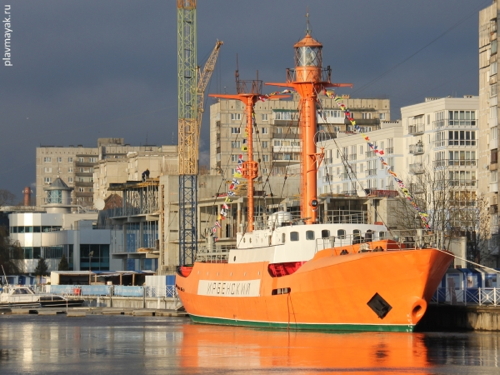
** Lightship Irbensky
1962. Decommissioned 1986 (a decorative light is now displayed). 43.4 m (142 ft) two-masted steel lightship with a lantern atop the mainmast. Hull and masts painted orange, superstructure white. Built in Finland for the Soviet Navy, the Irbensky was stationed on the Mikhailovskaya shoal in the Irbensky Strait, between Estonia and Latvia, until it was replaced by a lighthouse in 1985. It was then moved northwest to mark the beginning of the channel through the strait. After the collapse of the Soviet Union in 1991 the ship was moved in 1993-94 to the Russian Navy's hydrographic station at Lomonosov near St. Petersburg. Lightphotos.net has a good photo and Google has a 2013 street view of the ship moored in Lomonosov harbor. In 2009 the Navy announced that it would be scrapped, but a group of veterans quickly formed to advocate for the preservation of the lightship as a memorial. They organized a non-governmental organization, the Mayachny Foundation, to work for preservation of the lightship and Russian lighthouses. Through their efforts the Navy was moved to make repairs to the vessel assuring that it would remain afloat. For several years various proposals to preserve the vessel were considered but came to naught. In 2016 the World Ocean Museum in Kaliningrad agreed to renovate and display the ship. In October 2016 it was repaired at the Navy's Kronstadt Shipyard and in June 2017 it was towed to Kaliningrad. On the night of 8-9 July 2017 the light was restored. Interior restoration of the vessel is continuing. A photo of the ship at Kaliningrad is at right, Nikolai Chekomasov has a 2020 closeup photo, Sergey Ku has a 2018 view across the river, and Google has a satellite view. Located at the museum in downtown Kalinigrad. Site open; vessel sometimes open for tours (contact the museum for the schedule). Site manager: Museum of the World Ocean (Muzey Mirovogo Okeana).

Lightship Irbensky, Kaliningrad, December 2017
photo copyright Anton Ivanov; used by permission

Mys Taran and Pionerskiy Area Lighthouses
This area, a blunt peninsula projecting into the Baltic Sea, was known historically as Sambia. In Russia it is now called the Zemland Peninsula (Zemlandsky Poluostrov) or the Kaliningrad Peninsula (Kaliningradsky Poluostrov).
* Obzornyy
Date unknown. Active; focal plane 54 m (177 ft); white light, 2 s on, 3 s off. 22 m (72 ft) round masonry tower, brick over a stone base, with gallery. The original lantern has been replaced by a short skeletal tower carrying a small modern lantern. The brick tower is painted in orange-red and white horizontal bands; the stone base is unpainted, and the skeletal tower is painted red. Vladimir Baranovsky has a 2020 photo, Sergey Lyapustin has a photo, Sipaeva Katerina has a photo, and Google has a satellite view. In 2021 the lighthouse was repainted, as seen in Anton Zametin's photo. Located on the coast a few kilometers south of Yantarny and about 35 km (22 mi) north of Baltiysk. Site apparently open, tower closed. ARLHS KAL-005; Admiralty C3255; NGA 7114.
* Mys Taran {Brüsterort}
1846. Active; focal plane 54 m (177 ft); white light, occulting three times every 15 s. 29 m (95 ft) octagonal red brick tower with lantern and gallery. Tower is unpainted red brick; lantern and gallery painted yellow with black trim. Fog horn (one short and one long blast every 15 s). 2-story brick crew quarters building. Anastasia Kryukova's photo is at right, Aleksey Artemenko has a photo, Lightphotos.net has a photo, Julia Bezugla has a 2018 photo, Trabas has Werner Seiler's photo, Klaus Huelse has a historic postcard view of the lighthouse, and Google has a satellite view. Mys Taran is a prominent cape about 65 km (40 mi) north of Baltisyk, at the northwestern corner of the Kaliningrad Peninsula. There is another Mys Taran Light at the other end of Russia on the Sea of Okhotsk. Site status unknown but the lighthouse can be viewed from nearby. . ARLHS KAL-001; Admiralty C3256; NGA 7116.
* Pionerskiy {Neukuhren} Range Front
Date unknown. Apparently inactive but listed with focal plane 29 m (95 ft); red light, 2 s on, 2 s off, visible only on the range line. 20 m (66 ft) square cylindrical skeletal tower; the front of the tower carries a slatted daymark painted white with a black vertical stripe. Google has a closeup street view and an indistinct satellite view. Located southeast of the harbor at Pionerskiy. Site probably open, tower closed. ex-Admiralty C3257; NGA 7119.
* Pionerskiy {Neukuhren} Range Rear
Date unknown. Inactive since 2018. 16 m (52 ft) square cylindrical skeletal tower; the front of the tower carries a slatted daymark painted white with a black vertical stripe. No photo available but Google has an indistinct satellite view. Located 260 m (850 ft) south of the front light. Site probably open, tower closed. ex-Admiralty C3257.1; NGA 7119.1.

Mys Taran Light, Svetlogorsk, July 2019
Google Maps photo by Anastasia Kryukova
Mys Gvardeyskiy (Gvardeyskaya) {Rantauer Spitze}
Date unknown. Active; focal plane 50 m (164 ft); white flash every 4 s. 40 m (131 ft) square skeletal tower. The upper half of the tower is surrounded by a huge, drum-shaped daymark with the upper half painted black and the lower half white. Egor Falkovsky has a photo, Alexander Dyakov has a closeup photo, Veronika Filonova has a 2019 photo, and Google has a satellite view. This light is very similar to the Lesnoy Light shown below. Located about 500 m (0.3 mi) south southwest of a prominent cape about 8 km (5 mi) east of Pionerskiy. Site status unknown. ARLHS KAL-003; Admiralty C3262; NGA 7128.

Curonian Spit Lighthouses
The Curonian Spit (Kurshskaya Kosa) is a 98 km (61 mi) long barrier spit separating the Curonian Lagoon (Kurshskaya Zaliv) from the Baltic Sea. The southern half of the spit is in Russian Kaliningrad and the northern half is in Lithuania. Both countries have set aside most of the spit as protected nature reserves; the Russian portion of the spit is protected as the Kurshskaya Kosa National Park.

* Lesnoy {Sarkau, Warnicken} (3?)
Date unknown. Active; focal plane 44 m (144 ft); two white flashes every 9 s. 40 m (131 ft) square skeletal tower. The upper half of the tower is surrounded by a huge, drum-shaped daymark painted red with a white horizontal band. Kirill Shalamov's photo is at right, Trabas has Gundula Rentrop's photo, Vladas Portapas has a photo, Alexei Lykov has a street view from the beach, and Google has a satellite view. A sibling of the Mys Gvardeyskiy lighthouse. The first light here was a 13 m (43 ft) mast, and a 38 m (125 ft) skeletal tower was listed in the 1960s. Located just off the beach of the Curonian Spit about 10 km (6 mi) northeast of Zelenogorsk. Site open, tower closed. ARLHS KAL-004; Admiralty C3270; NGA 7130.
Rybachiy (Rybatschi) {Rossiten} (2)
Date unknown (station established 1867). Active; focal plane 55 m (180 ft); one short and one long white flash every 6 s. 24 m (79 ft) square cylindrical skeletal tower painted with red and white horizontal bands; at least two sides are covered by a slatted daymark painted red. No photo available but Google has a satellite view and the light is on the horizon in a very distant drone view by Artyom Belousov. Huelse has a historic postcard view of the 1867 lighthouse, a short cylindrical tower attached to a 1-1/2 story keeper's house; Michel Forand has a second postcard view. The station is located on the Curonian Spit about 30 km (19 mi) northeast of Zelenogradsk and 20 km (13 mi) southwest of the lighthouse at Nida, Lithuania. Site status unknown. ARLHS KAL-006; Admiralty C3277; NGA 7132.

Lesnoy Light, May 2017
ex-Google Maps photo by Kirill Shalamov
* Rybachiy Jetty
Date unknown. Active(?); light characteristic, if any, unknown. Approx. 4 m (13 ft) round red brick tower with narrow white horizontal bands. A 2021 closeup photo is available, Vitaliy Pavlov has a more distant view, and Google has a satellite view. Located at the end of a jetty on the lagoon side of the spit at Rybachiy. Site open, tower closed. Not listed by the Admiralty.

Curonian Lagoon Lighthouse
The Curonian Lagoon (Kurshkiy Zaliv in Russian) is a large, shallow bay separated from the Baltic by the Curonian Spit. Shaped like a wedge, the lagoon is about 100 km (60 mi) long and 50 km (30 mi) wide at its southern end. The southern two thirds of the lagoon is in Kaliningrad and the northern third in Lithuania. There are several lighthouses on the lagoon in Lithuania.

**
Zalivino (Labaginena) {Rinderort} (2)
1889 (station established 1868). Reactivated (inactive 1985-2021); focal plane about 20 m (66 ft); continuous (?) white light. 15 m (49 ft) round cylindrical red brick tower with lantern and gallery, attached to a 1-1/2 story keeper's house. The abandoned lighthouse deteriorated severely, as seen in Lyuts Shnayder's 2018 photo, a 2019 photo by Karina Misiunas, and Olga Yakovleva's photo. In 2020 management of the light station was transferred to the Museum of the World Ocean in Kaliningrad, and the museum acted immediately to restore and reactivate the lighthouse. Ekaterina Isakova's photo of the restored lighthouse is at right, Visit Kaliningrad has an August 2021 photo of the light in action, Huelse has a historic postcard view, and Google has a satellite view. The keeper's house has a new roof but is not yet fully restored. Located on a point of land on the south shore of the sound about 1.5 km (1 mi) northwest of Zalivino. Site open; Isakova reports that there is a caretaker on site and the tower is open officially on Fridays and Saturdays and unofficially by arrangement with the caretaker. Owner/site manager: Museum of the World Ocean (Muzey Mirovogo Okeana). . ex-Admiralty C3290.

Information available on lost lighthouses:

  • Deime Range Rear (?-?), Zalivino (Rinderort). According to Michel Forand this light was listed by the Admiralty from the 1920s through 1984.
  • Golowkino {Eichwerder} (1920s-30s). Google has a satellite view of the location of this light on the east coast of the Curonian Lagoon.

Notable faux lighthouses:


Zalavino Light, Zalivino, November 2021
Instagram photo by Ekaterina Isakova

Adjoining pages: North: Lithuania | West: Poland's Baltic Coast

Return to the Lighthouse Directory index | Ratings key

Posted May 22, 2005. Checked and revised July 3, 2024. Lighthouses: 31; lightships: 1. Site copyright 2024 Russ Rowlett and the University of North Carolina at Chapel Hill.