Lighthouses of Korea: Seogwipo City (Southern Jeju)

For most of its history Korea was an independent kingdom, or at least an autonomous kingdom under Chinese influence. This came to an end in 1910 when Japan annexed all of Korea. At the end of World War II in 1945 the 38° parallel was established as the dividing line between U.S. and Soviet zones of occupation, and in 1948 separate civil administrations were established in the two halves of the country. The Korean War (1950-53) ended in a draw with the armistice line falling close to the prewar 38° line. The Republic of Korea (ROK; 대한민국, Daehan Minguk in Korean), commonly called South Korea, occupies the Korean peninsula south of the armistice line.

Jeju (formerly spelled Cheju) is an island province of South Korea located off the southwestern end of the Korean Peninsula. Dominated by the dormant volcano Hallasan, Korea's tallest mountain at 1947 m (6388 ft), Jeju is roughly 75 km (45 mi) long and 25 km (15 mi) wide. More than half a million people live on the island. The province is divided administratively into two cities, Jeju on the north side and Seogwipo on the south side. This page has the lighthouses of Seogwipo; those of Jeju City are on a separate page. The second largest city of Jeju Island and southernmost city of Korea, Seogwipo is a city of about 150,000 residents.

Jeju is readily accessible by air or by ferry from Busan, Tongyeong, Wando, Mokpo, or Incheon.

Navigational aids in the ROK are regulated by the Ministry of Oceans and Fisheries (MOF). The lights on this page are maintained by the Jeju Maritime Management Division, a branch of the Busan Regional Oceans and Fisheries Administration.

In 2000 South Korea adopted a Revised Romanization System to replace systems formerly used in the West. In the Revised System, the word for a lighthouse is deungdae (등대); dan (formerly tan) is a cape, seom (som) or do (to) is an island, am or amseog is a rock, man is a bay, and hang is a harbor. Some place names may be more familiar to Westerners in the spellings of older systems.

ARLHS numbers are from the ARLHS World List of Lights. KR numbers, where available, are from the Korean light list. Admiralty numbers are from volume M of the Admiralty List of Lights & Fog Signals. U.S. NGA List numbers are from Publication 112.

General Sources
Online List of Lights - Korea
Photos by various photographers posted by Alexander Trabas.
Navionics Charts
Navigation chart for Seogwipo.


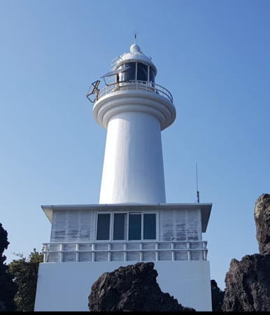
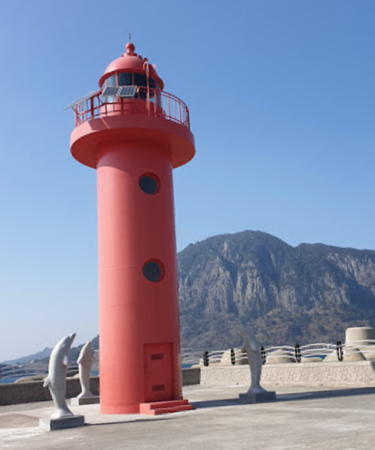
Hayejinhwang Light, Seogwipo, March 2018
Google Maps photo by Kanji Shinohara
Seongsan Town Lighthouses
Seongsan is a fishing port and ferry terminal at the east end of Jeju. Seongsan (Sunrise Peak) is also the name of a rocky headland at the eastern end of Jeju Island popular for its wide view of the sea. Seongsanpo is the port for ferries traveling to Udo Island (see Jeju City).
Seongsanpo (Songsanpo, Jongdal)
Date unknown. Active; focal plane 15 m (49 ft); two red flashes every 6 s. 20 m (66 ft) tower, painted red, mounted on a round concrete pier. No photo available but Google has a satellite view and a very distant street view. Located on a shoal about 1.5 km (1 mi) north of Seongsanpo. Accessible only by boat. Site open, tower closed. KR-2625.5; Admiralty M4272.25; NGA 17429.
Seongsanpo (Songsanpo) West Breakwater
Date unknown. Active; focal plane 12 m (39 ft); red flash every 5 s. 11 m (36 ft) round cylindrical concrete tower with lantern and gallery. Entire lighthouse is yellow (NGA lists the tower as red). Kim Cheol Bong has a closeup photo, this light is at the lower center of the photo at right, and Google has a satellite view. Located at the end of the east breakwater of Seongsanpo. Site status unknown. KR-2625; Admiralty M4272.42; NGA 17432.
Seongsanpo (Songsanpo) North Breakwater West Head
Date unknown. Active; focal plane 16 m (52 ft); two green flashes every 6 s. 15 m (49 ft) round cylindrical concrete tower with lantern and gallery. Entire lighthouse is yellow. Kim Cheol Bong has a closeup photo, this light is at the right side of the photo at right, and Google has a satellite view. Located at the west end of the detached main breakwater of Seongsanpo. Accessible only by boat. Site and tower closed. KR-2624; Admiralty M4272.36; NGA 17435.
Seongsanpo (Songsanpo) North Breakwater East Head
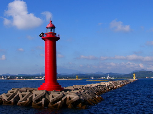
Date unknown. Active; focal plane 16 m (52 ft); two red flashes every 6 s. 15 m (49 ft) round cylindrical concrete tower with lantern and gallery, painted red. A photo is at right, Kim Cheol Bong has a closeup photo, another photo is available, Wikimedia has Changhee Han's photo, and Google has a satellite view. Located at the east end of the detached main breakwater of Seongsanpo. Accessible only by boat. Site and tower closed. KR-2623; Admiralty M4272.35; NGA 17434.
Seongsanpo North Breakwater Light
North Breakwater East Head Light, Seongsanpo, October 2010
(West Head Light at the right, West Breakwater Light in the center distance)
ex-Panoramio photo copyright 가흔파파 (Gaheunpapa); permission requested
Seongsanpo (Songsanpo) East Breakwater
Date unknown. Active; focal plane 17 m (56 ft); green flash every 4 s. 15 m (49 ft) round cylindrical concrete tower with lantern and gallery, painted white. Kim Cheol Bong has a closeup photo, Jerry Baker has a second closeup, there's a view from the sea, and Google has a satellite view. Located at the east end of the main breakwater of Seongsanpo. Accessible only by boat. Site and tower closed. KR-2622; Admiralty M4272.3; NGA 17424.
* Bangdupo (Pangdupo)
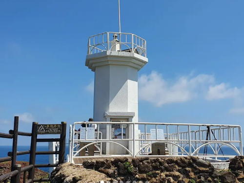
Date unknown. Active; focal plane 40 m (141 ft); white flash every 4 s. 12 m (39 ft) octagonal cylindrical concrete tower with gallery, painted white. Jang Do-hyung's 2021 photo is at right, a 2016 photo is available, Byeong Seong Lim has a 2023 closeup, Jay Bek's photo shows the long flight of stairs leading to the lighthouse, Choi Jae-pil has a street view, and Google has a satellite view. Offering a wide view of the Korea Strait, this lighthouse is a popular observation point. Located on a promontory at the southeastern tip of Jeju, about 3 km (2 mi) southeast of Tongnam. Site open, tower closed. . KR-2626; Admiralty M4272.5; NGA 17436.
* Onpyeong
1906. Inactive. 4 m (13 ft) square basalt rubblestone tower. A photo and a second photo are available, Google has a street view, and Google has a satellite view. Small traditional stone lightstands of this kind, called daetbul, are found at many small Korean harbors. This is one of the larger examples. Located on the waterfront of Onpyeong. Site open, tower closed.
Onpyeong (On Pyeong) Reef
Date unknown. Active; focal plane 14 m (46 ft); three quick white flashes every 10 s. 13 m (43 ft) round cylindrical concrete tower with gallery, painted black with one yellow horizontal band. A photo is available and Google has a satellite view and a distant street view from shore. Located on a shoal off a promontory on the southeast coast of Jeju, about 1.2 km (3/4 mi) southeast of Onpyeong. Accessible only by boat. Site open, tower closed. KR-2639; Admiralty M4272.54; NGA 17440.

Bangdupo Light, Tongnam, August 2021
Instagram photo by Jang Do-hyung

Pyoseon Township Lighthouses
* Pyoseon Hang
Date unknown. Active; focal plane 12 m (39 ft); green flash every 4 s. 9 m (30 ft) round cylindrical white concrete tower. Park Kyung-chan has a 2021 photo, another photo and a third photo are available, and Google has an indistinct satellite view. Located on the east breakwater of Pyoseon, a small port about 15 km (9 mi) southwest of Pangdupo. Accessible by walking the pier. Site open, tower closed. Admiralty M4272.57; NGA 17448.
* Gaeminpo (Kaeminpo) (2)
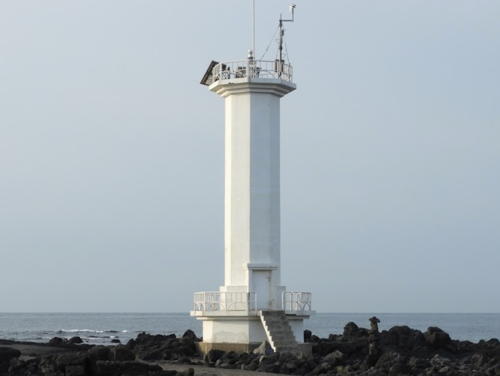
Date unknown. Active; focal plane 14 m (46 ft); white flash every 5 s. 12 m (39 ft) octagonal cylindrical white concrete tower with gallery. Rudy Muller has the 2019 photo at right, Tim Wang has a 2008 photo, and Google has a street view and a satellite view. The present tower is taller than the one previously described by the light lists. Located on a promontory about 800 m (1/2 mi) south of Pyoseon Hang. Site open, and visitors can climb atop the base of the tower; tower closed. . KR-2640; Admiralty M4272.6; NGA 17444.
* Gaeminpo Got (Kaeminpo Got, Gama) (2)
Date unknown. Active; focal plane 16 m (52 ft); white flash every 9 s. 12 m (39 ft) octagonal cylindrical concrete tower with upper and lower galleries, painted white. A foggy photo and a 2021 photo are available and Google has a street view and a satellite view. NGA formerly listed a small skeletal tower at this location. Located on a promontory on the east side of Taemeung Hang, a harbor about 16 km (10 mi) east of Seogwipo. Site open, tower closed. KR-2641.2; Admiralty M4272.7; NGA 17452.

Namwon Town Lighthouses
Daebongangot (Taebonggot)
Date unknown. Active; focal plane 13 m (43 ft); white flash every 6 s. 12 m (39 ft) octagonal cylindrical concrete tower with gallery. Entire lighthouse is white. A photo (just over halfway down the page) is available, and Google has a distant satellite view. Located at the foot of a steep headland about 25 km (15 mi) east of Seogwipo harbor. Site status unknown. KR-2642; Admiralty M4272.75; NGA 17454.

Gaeminpo Light, April 2019
Google Maps photo by Rudy Muller
Bangiyeo (Bangi-yeo)
Date unknown. Active; focal plane 17 m (56 ft); six quick white flashes and one long white flash every 15 s. 22 m (72 ft) round concrete tower, upper half painted yellow and lower half black. A photo (1/4 the way down the page) is available and Google has a satellite view and a distant street view from shore. Located on an offshore reef about 6.5 km (4 mi) east of Wimi Hang. Accessible only by boat, although there should be a good view from shore. Site open, tower closed. KR-2642.5; Admiralty M4272.78; NGA 17454.5.
* Wimi Hang East Breakwater (2?)
Date unknown. Reactivated (inactive 2017-2020); focal plane 19 m (62 ft); red flash every 6 s. 10 m (33 ft) round cylindrical concrete tower, painted red. A closeup photo is available and Google has a satellite view and a distant street view. The light was inactive while the breakwater was extended by 150 m (492 ft). Located at the end of the east breakwater at Wimi Hang, a harbor about 12 km (7.5 mi) east of Seogwipo. Accessible by walking the pier. Site open, tower closed. KR-2643; Admiralty M4272.9; ex-NGA 17455.
* Wimi Hang West Breakwater
Date unknown. Active; focal plane 13 m (43 ft); green flash every 6 s. 10 m (33 ft) round cylindrical concrete tower, painted white. Younghoon Kim has a view from the sea and Google has a satellite view and a distant street view. Located at the end of the west breakwater at Wimi Hang. Accessible by walking the pier. Site open, tower closed. KR-2644; Admiralty M4272.95; NGA 17455.5.
Chigwido (Jigwido, Chigwi Do)
Date unknown. Active; focal plane 17 m (56 ft); white flash every 5 s. 12 m (39 ft) round cylindrical concrete tower, painted white. A closeup photo, a second photo and a more distant view are available, and Google has a satellite view. Chigwi Do is a small island about 5 km (3 mi) south of Wimi Hang. Located on the north side of the island. Site status unknown. KR-2645; Admiralty M4272.8; NGA 17456.

Hahyo Ward Lighthouses
* Hahyo Hang North Breakwater
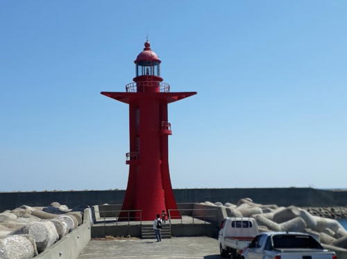
2013. Active; focal plane 18 m (59 ft); two red flashes every 6 s. 15 m (49 ft) round concrete tower with lantern and gallery. Entire lighthouse is red. A photo is at right, the light is at the left in Sangik Han's photo, Brian Wolff has a street view, and Google has a satellite view. Located on the north breakwater at Hahyo harbor. Accessible by walking the pier. Site open, tower closed. KR-2645.2; Admiralty M4272.955; NGA 17456.2.

Hahyo Hang North Breakwater Light, Seogwipo, May 2021
Google Maps photo by Cuy's Life Fishing
Hahyo Hang South Breakwater
2013. Active; focal plane 18 m (59 ft); two red flashes every 6 s. 12 m (39 ft) round concrete tower with lantern and gallery. Entire lighthouse is white. A 2021 photo is available, the light is at the right in Sangik Han's photo, Brian Wolff has a street view from the north breakwater, and Google has a satellite view. Located on the detached south breakwater at Hahyo harbor. Site open, tower closed. KR-2645.3; Admiralty M4272.958; NGA 17456.1.

Songwi Ward (Seogwipo Harbor) Lighthouses
* Seogwipo Oehang (East) Breakwater
Date unknown. Active; focal plane 17 m (56 ft); red flash every 4 s. 15 m (49 ft) round concrete tower with lantern and gallery. Entire lighthouse is red. Michael Sotnikov's photo is at right, Malison Addox has a photo, a view from the sea is available, and Google has a good satellite view. Located at the end of the main (east) breakwater of Seogwipo. Accessible by walking the pier. Site open, tower closed. KR-2649.1; Admiralty M4274.505; NGA 17467.
* Seogwipo South Breakwater
Date unknown. Reactivated (inactive 2014-2020); focal plane 17 m (56 ft); green flash every 4 s. 14 m (46 ft) round cylindrical concrete tower with lantern and gallery. Entire lighthouse is white. Baek Seung Hwa has a photo, another photo is available, Seung Gon Baek has a sea view, and Google has a satellite view. This is a relatively new light; the present south breakwater was not built until sometime after 2006. Located at the end of the south (really west) breakwater of Seogwipo. Probably accessible by walking the pier. Site open, tower closed. KR-2648; Admiralty M4273.5 (ex-M4274.2); ex-NGA 17462.

East Breakwater Light, Seogwipo, October 2008
Flickr Creative Commons photo by Michael Sotnikov
Nokdo (Munseom, Moonseom, Nok Do)
Date unknown. Active; focal plane 96 m (315 ft); white flash every 6 s. 9 m (30 ft) round white concrete tower. The top of the light is seen in a view from the sea and Google has an indistinct satellite view. Located atop the east end of Moonseom, a small but high island 500 m (0.3 mi) south of the Seogwipo harbor entrance. Accessible only by boat. Site status unknown. KR-2646; Admiralty M4273; NGA 17468.

Gangjeong Ward Lighthouses
Daecheon East Breakwater
2015-16. Active; focal plane about 15 m (49 ft); red light, characteristic unknown. Approx. 13 m (43 ft) round cylindrical concrete tower with lantern and gallery. Entire lighthouse is red. A distant view and a distant view of both breakwater lights are available and Google has a satellite view. Daecheon is an industrial town and naval base about 8 km (5 mi) west of Seogwipo. Located at the end of the east breakwater of Daecheon harbor. Site and tower closed (naval base). KR-2652.1; Admiralty M4274.523.
Daecheon West Breakwater
2015-16. Active; focal plane about 15 m (49 ft); green light, characteristic unknown. Approx. 13 m (43 ft) round cylindrical concrete tower with lantern and gallery. Entire lighthouse is white. A distant view of both breakwater lights is available but Google has a satellite view. Located at the end of the east breakwater of Daecheon harbor. Site and tower closed (naval base). KR-2652.2; Admiralty M4274.522.
Sebyeolgot
Date unknown. Active; focal plane 19 m (62 ft); three quick white flashes every 10 s. 22 m (72 ft) round concrete tower with gallery, painted black with one yellow horizontal band. Chun DooRee has a 2022 photo, Ryoko Kato has a 2023 photo, and Google has a satellite view and a distant street view. Located on a rock just west of Daecheon harbor. Accessible only by boat. Site open, tower closed. KR-2652.4; Admiralty M4274.55; NGA 17476.1.

Yerae Ward Lighthouse
Hayejinhwang (Hayejin Hwang)
Date unknown. Active; focal plane 22 m (72 ft); white flash every 7 s. 12 m (39 ft) round white concrete tower with lantern and gallery. Kanji Shinohara has a closeup photo (a portion is seen at the top of this page), a 2019 closeup and a drone view are available, and Google has a street view and a satellite view. Located on a sharp promontory sheltering a small harbor about 20 km (13 mi) west of Seogwipo. Site open, tower closed. KR-2655; Admiralty M4274.58; NGA 17477.

Andeok Township Lighthouses
* Hwasun Hang Outer Breakwater
Date unknown. Active; focal plane 24 m (79 ft); red flash every 5 s. 15 m (49 ft) round red concrete tower with lantern and gallery. Jaenam Kim has the closeup photo seen at right, a photo of both breakwater lighthouses is available, and Google has a satellite view. Located on the main breakwater of Hwasun near the southwestern point of Jeju. Accessible by walking the pier. Site open, tower closed. KR-2657; Admiralty M4254.9; NGA 17489.
* Hwasun Hang North (Inner) Breakwater
Date unknown. Active; focal plane 24 m (79 ft); green flash every 5 s (?). 15 m (49 ft) round white concrete tower with lantern and gallery. Frank Ng has a drone view, a photo of both breakwater lighthouses is available and Google has a satellite view. Located on the north (really west) breakwater of Hwasun. Site status unknown. KR-2657.13; Admiralty M4254.95.
Sagye Hang
Date unknown. Active; focal plane 16 m (52 ft); red flash every 6 s. 13 m (43 ft) round cylindrical concrete tower with lantern and gallery, painted red. A closeup photo and a distant view are available, Cheol Lee has a 2020 view, and Google has a satellite view. Located at the end of the main (east) breakwater of Sagye, a small port about 4 km (2.5 mi) west of Hwasun near the southwestern point of Jeju. Site status unknown. Admiralty M4254.8; NGA 17490.

Hwasun Hang Outer Breakwater Light, Andeok, February 2019
Google Maps photo by Jaenam Kim

Daejeong Town Lighthouses
*** Marado (Mara-do, Mara Island) (3)
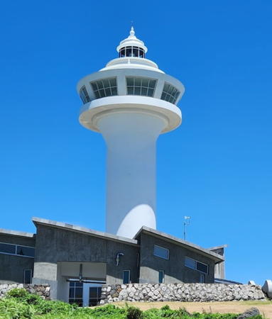
2022 (station established 1915). Active; focal plane 65 m (213 ft); white flash every 10 s. 32 m (105 ft) white concrete tower with observation room, lantern and gallery. 2-story crew building and other light station buildings. A 2023 photo is at right, Jong-sik Lee has a more distant view, and Google has a satellite view. This lighthouse replaced the 1957 lighthouse, a 16 m (52 ft) octagonal tower with lantern and gallery. Hong Tae-seong has a 2020 photo of that light, a 2008 photo is available, JungHwan Choi has another photo, and Google has a 2015 street view. Marado (Mara Island) is a small island about 7 km (4.5 mi) south of the southwestern point of Jeju. The island is accessible by a daily ferry from Moseulpo. Located atop a vertical cliff on the eastern side of the island. Accessible only by boat. Site open and tower open. . ARLHS SKR-016; KR-2661; Admiralty M4254; NGA 17480.
Gwangpotan (Kwangpotan)
Date unknown. Active; focal plane 15 m (49 ft); two white flashes every 5 s. 11 m (36 ft) round concrete tower, painted black with one red horizontal band. A photo is available and Bing has a fuzzy satellite view. Located on a reef about 3 km (2 mi) south of the southwestern point of Jeju and about 1.5 km (1 mi) east of Gapado, an island midway between Marado and the mainland. Accessible only by boat. Site open, tower closed. KR-2660; Admiralty M4254.3; NGA 17483.
Donongtang (Gapado)
Date unknown. Active; focal plane 17 m (56 ft); six quick white flashes followed by one long white flash every 15 s. 22 m (72 ft) concrete post mounted on a concrete pier. Upper half of the lighthouse painted yellow, lower half black. The light is visible in the distance in Doohyuk Kim's aerial view of Gapado and Google has an indistinct satellite view. Located about 400 m (1/4 mi) southeast of the southern point of Gapado. Accessible only by boat. Site open, tower closed. Admiralty M4254.15.
Gwabutan (Kwabutan) (4?)
Date unknown (station established 1998). Active; focal plane 16 m (52 ft); two white flashes every 10 s. 19 m (62 ft) round metal tower, painted black with one red horizontal band. No photo available and the light is not seen in Google's satellite view. From various sources it appears that lights here have been repeatedly destroyed or damaged by typhoons and other storms. Located on a reef about 3 km (2 mi) southwest of the southwestern point of Jeju. Accessible only by boat. Site open, tower closed. Admiralty M4254.35; NGA 17483.5.

Marado Light, Marado, August 2023
Google Maps photo by MIS PARK
* Moseulpo Nam Hang (South Harbor)
Date unknown. Active; focal plane about 16 m (52 ft); two green flashes every 6 s. 11 m (36 ft) round tapered concrete tower with lantern and gallery. Entire lighthouse is white. Hyun-seok Jun has a closeup night time street view, Jong-sik Lee has a 2023 view from the sea, a 2023 video view and an overhead drone view are available, and Google has an indistinct satellite view. Located at the end of the breakwater of the new south harbor of Moseulpo. Accessible by walking the pier. Site open, tower closed. KR-2663.5; Admiralty M4254.355; NGA 17484.1.
Moseulpo (Mosulpo) Buk Hang (North Harbor) East Breakwater
Date unknown. Active; focal plane 15 m (49 ft); red flash every 5 s. 10 m (33 ft) round cylindrical concrete tower, painted red. Choi Gwang Shin has a closeup photo, a 2021 photo shows both breakwater lights, and Google has a street view and satellite view. Moseulpo is the terminal for ferries to Mara-do. Located at the end of the east breakwater at Moseulpo Hang, a harbor about 3 km (2 mi) northwest of the southwestern corner of Jeju. Site status unknown. KR-2664; Admiralty M4254.6; NGA 17484.
Moseulpo (Mosulpo) Buk Hang (North Harbor) West Breakwater
Date unknown. Active; focal plane 17 m (56 ft); green flash every 5 s. 10 m (33 ft) round cylindrical concrete tower, painted white. A 2018 photo is available, Wai Tong Ho has a closeup photo of the light in action, Jeong Seong Hun has a view of both breakwater lights from inside the harbor, and Google has a street view and a satellite view. Located at the end of the west breakwater at Moseulpo Hang. Site status unknown. KR-2665; Admiralty M4254.4; NGA 17488.

Ieodo (Socotra Rock) Lighthouse
Ieodo (Socotra Rock, Suyan Rock)
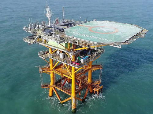
Date unknown (station established 2001). Active; focal plane 37 m (121 ft); two short white flashes followed by a long white flash (Morse Code "U") every 15 s. Fog horn (three blasts in the same "U" pattern every 30 s). Light mounted on a square platform supporting a helipad and solar-powered research station. A photo is at right and another photo is available but the platform is not shown in Google's satellite view. Socotra Rock is a submerged reef (the summit of a dormant undersea volcano) in the East China Sea 149 km (93 mi) southwest of Mara Island. At low tide the reef is 4.6 m (15 ft) below sea level. Both South Korea and China claim this patch of the ocean for their exclusive economic zones. The platform was built by Korea between 1995 and 2001; it carries the automated Ieodo Ocean Research Station. Accessible only by boat. Site open, tower closed. KR-2662.5; Admiralty M4252; NGA 17481.

Ieodo Platform, East China Sea, October 2021
Wikimedia photo by Korea Ocean Research Station

Information available on lost lighthouses:

Notable faux lighthouses:

Adjoining page: North: Jeju City

Return to the Lighthouse Directory index | Ratings key

Posted December 10, 2007. Checked and revised March 28, 2024. Lighthouses: 36. Site copyright 2024 Russ Rowlett and the University of North Carolina at Chapel Hill.