Lighthouses of South Korea: Gochang and Buan Counties

For most of its history Korea was an independent kingdom, or at least an autonomous kingdom under Chinese influence. This came to an end in 1910 when Japan annexed all of Korea. At the end of World War II in 1945 the 38° parallel was established as the dividing line between U.S. and Soviet zones of occupation, and in 1948 separate civil administrations were established in the two halves of the country. The Korean War (1950-53) ended in a draw with the armistice line falling close to the prewar 38° line. The Republic of Korea (ROK), commonly called South Korea (Daehan Minguk in Korean), occupies the Korean peninsula south of the armistice line.

South Korea is divided into nine provinces and eight province-level cities; the provinces are subdivided into counties and cities. This page covers lighthouses of Gochang County and Buan County in Jeollabuk (North Jeolla) Province, located on South Korea's southwest coast in the region formerly known as Jeolla or Cholla. The coast of Jeollabuk faces west on the Yellow Sea (usually called the West Sea in Korea). Gochang and Buan Counties are a mostly rural area between the cities of Mokpo to the south and Gunsan and Gimje to the north. Buan County includes the Byeonsan Peninsula and the resort island of Wido.

In 2000 South Korea adopted a Revised Romanization System to replace systems formerly used in the West. In the Revised System, the word for a lighthouse is deungdae (등대); dan (formerly tan) is a cape, seom (som) or do (to) is an island, am or amseog is a rock, man is a bay, and hang is a harbor. Some place names may be more familiar to Westerners in the spellings of older systems.

Navigational aids in the ROK are regulated by the Ministry of Oceans and Fisheries (MOF). The lights in Gochang and Buan Counties are maintained by the Gunsan Regional Office of Oceans and Fisheries.

ARLHS numbers are from the ARLHS World List of Lights. KR numbers, where available, are from the Korean light list. Admiralty numbers are from volume M of the Admiralty List of Lights & Fog Signals. U.S. NGA List numbers are from Publication 112.

General Sources
Online List of Lights - Korea - Yellow Sea
Photos by various photographers posted by Alexander Trabas.
Navigational Beacon Management Office
Information from the Gunsan Oceans and Fisheries Office.
Navionics Charts
Navigation chart for western South Korea.


South Breakwater Light, Gusipo, March 2021
Google Maps photo by Siwoo Lee

Gochang County Lighthouses

Sangha Township Lighthouses
* Gusipo Hang South Breakwater
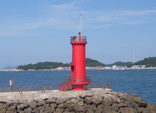
Date unknown. Active; focal plane 21 m (69 ft); red flash every 5 s. Approx. 17 m (56 ft) round concrete tower with lantern and gallery. Entire lighthouse is red. Siwoo Lee's photo is above, Chae Seop Lim has a photo of both breakwater lighthouses, Yangchun Bok also has a photo, and Google has a street view and a satellite view. Gusipo Hang is a marina built on an artificial island connected to shore by a long pier. Located on the south breakwater of the marina. Site open, tower closed. KR-3147.9; Admiralty M4207.974.
* Gusipo Hang North Breakwater
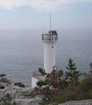
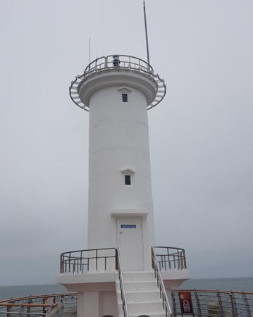
Date unknown. Active; focal plane 21 m (69 ft); green flash every 5 s. Approx. 17 m (56 ft) round concrete tower with lantern and gallery. Entire lighthouse is white. Chae Seop Lim has a photo of both breakwater lighthouses, Yangchun Bok also has a photo, Yongil Jeong has a closeup street view (also seen at right), and Google has a satellite view. Located on the north breakwater of the marina. Site open, tower closed. KR-3147.10; Admiralty M4207.972.
Jinyeo (2)
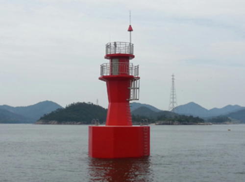
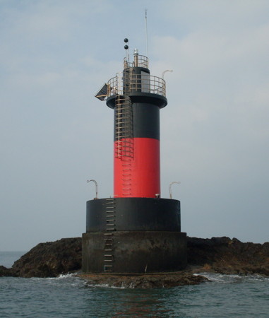
2024 (station established 2018). Active; focal plane 16 m (43 ft); two white flashes every 10 s. 19 m (46 ft) round steel tower painted black with one red horizontal band. Google has a satellite view and a distant street view. Listed by the Admiralty as Gusipo Hang. Located on a shoal on the north side of the Gusipo Hang marina. Accessible only by boat but easy to see from the marina. Site open, tower closed. KR-3127.45; Admiralty M4207.964.

Haeri Township Lighthouse
* Gochang (South Mohang Hang Breakwater)
Date unknown. Active; focal plane about 11 m (69 ft); red light, pattern unknown. Approx. 8 m (26 ft) square skeletal tower with two horizontal daymarks. Entire lighthouse is red. Google has a street view and a satellite view. Located on a short breakwater on the west side of the entrance to Mohang Bay. Site open, tower closed. KR-3147.4; Admiralty M4207.96.

North Breakwater Light, Gusipo, December 2020
Google Maps photo by Yongil Jeong

Buan County Lighthouses

Wido Township Lighthouses
Wido is an island about 15 km (9 mi) off the coast near Gyeokpo. The island is a well known resort area readily accessible by ferry from Gyeokpo.
Sangwangdeungdo (Sangwangdung Do)
Date unknown. Active; focal plane 174 m (571 ft); white flash every 5 s. 5 m (17 ft) round white concrete tower. A 2022 photo is available and Bing has a distant satellite view. Located on an isolated high island (one of two) in the Yellow Sea about 15 km (9 mi) west northwest of Wido. Accessible only by boat. Site open, tower closed. KR-3148; Admiralty M4206.6; NGA 17744.
* Taeri (Daeri) Hang
Date unknown. Active; focal plane 13 m (43 ft); green flash every 6 s. 9 m (30 ft) round white concrete tower. No photo available but Bing has a satellite view. Located at the end of the south breakwater at Taeri, a small port near the southwestern tip of Wido. Accessible by walking the pier. Site open, tower closed. Admiralty M4206.95; NGA 17727.5.
* Wido
Date unknown. Active; focal plane 22 m (72 ft); white flash every 4 s. 10 m (33 ft) round cylindrical white concrete tower, mounted on a square concrete base. M.C. Han's photo is at right and Google has an indistinct satellite view. Located at the southwestern tip of Wido. Probably accessible by a short hike. Site open, tower closed. KR-3149.4; Admiralty M4206.955; NGA 17727.6.
Georyundo (Koryundo, Tokkiseom)
Date unknown. Active; focal plane 35 m (115 ft); white flash every 6 s. 14 m (46 ft) square cylindrical white concrete tower. Shin Chu-yeon has a 2022 photo, a distant view (last photo on the page) and a second distant view are available, and Google has an indistinct satellite view. Located on an islet off the western tip of Wido. Accessible only by boat. Site status unknown. KR-3149; Admiralty M4207; NGA 17726.
Oejodo
Date unknown. Active; focal plane 15 m (49 ft); two white flashes every 10 s. 13 m (43 ft) metal tower, painted black with one red horizontal band. No photo available but Google has an indistinct satellite view. Located on a rock about 1.5 km (0.9 mi) north of the Georyundo light. Accessible only by boat. Site status unknown. KR-3149.2; Admiralty M4207.21.
Baejamyeo (Pejamyeo, Pejamyo)
Date unknown. Active; focal plane 15 m (49 ft); two white flashes every 5 s. 16 m (52 ft) tower, painted black with one red horizontal band. No photo available but Google has an indistinct satellite view. Located on a rock about 2.5 km (1.5 mi) off the western end of Wido. Accessible only by boat. Site status unknown. KR-3149.7; Admiralty M4207.2; NGA 17726.5.
Moyeo
Date unknown. Active; focal plane 16 m (52 ft); nine quick white flashes every 15 s. 17 m (56 ft) metal tower, painted yellow with one black horizontal band. A 2024 photo is available, the light is near the left edge of a distant view, and Google has a fuzzy satellite view. The Korean and Admiralty lists identify this light only as "Wido"; the name Moyeo is from Navionics. Located on a reef off the west coast of Wido. Accessible only by boat. Site status unknown. KR-3149.1; Admiralty M4207.22.
Wido Light
Wido Light, Wido, September 2009
ex-Panoramio Creative Commons photo by M.C. Han
Galmaeyeo (Kalmaeyo)
Date unknown. Active; focal plane 14 m (46 ft); two white flashes every 10 s. 17 m (56 ft) tower, painted black with one red horizontal band. No photo available and the reef is not shown in Google's satellite view. Located on a rock about 2.5 km (1.5 mi) northeast of the Baejamyeo beacon. Accessible only by boat. Site status unknown. KR-3154; Admiralty M4206.7; NGA 17727.
Beolgeumyeo (Dalludo)
Date unknown. Active; focal plane 16 m (52 ft);two white flashes every 5 s. 20.5 m (67 ft) round concrete tower, painted black with one red horizontal band. No photo available but Google has a satellite view. Located on a rock off the northwestern tip of Wido. Accessible only by boat. Site status unknown. KR-3149.6; Admiralty M4206.73.
* Beolgeum Hang
Date unknown. Active; focal plane 11 m (36 ft); red flash every 5 s. 7.5 m (25 ft) round red fiberglass tower. No photo available but Google has an indistinct satellite view. Located on the breakwater of Beolgeum, a small port on a sheltered harbor on the north coast of Wido. Presumably accessible by walking the pier. Site open, tower closed. KR-3151.3; Admiralty M4206.74.
Jeongeumdo
Date unknown. Active; focal plane about 13 m (43 ft); nine quick white flashes every 10 s. Approx. 13 m (43 ft) round cylindrical concrete tower painted yellow with a black horizontal band. KiJu Ryu has a 2023 photo and Google has a satellite view. Located off Jeonggeumdo, a small island off the northern tip of Wido. Accessible only by boat. Site status unknown. KR-3150.8; Admiralty M4206.745.
Sikdo West
Date unknown. Active; focal plane 16 m (52 ft); nine quick white flashes every 15 s. 14 m (46 ft) round metal tower. No photo available but Google has an indistinct satellite view. Located on a rocky reef off the west coast of Sikdo, a smaller island north of Wido. Accessible only by boat. Site status unknown. KR-3150.3; Admiralty M4206.71.
Sikdo South
Date unknown. Active; focal plane 13 m (43 ft); green flash every 4 s. 18 m (39 ft) round cylindrical concrete tower painted green. The light is visible near the left edge in a drone view and near the right edge of a 2024 photo, and Google has a satellite view. Located on a reef off the south end of Sikdo, a smaller island north of Wido. Accessible only by boat. Site status unknown. Admiralty M4206.75.
Sikdoyeo (Sikdo East)
Date unknown. Active; focal plane 13 m (43 ft); red flash every 4 s. 15 m (49 ft) round cylindrical concrete tower painted red. A photo is at right, the light is seen in the distance in a photo showing the Pajanggeum breakwater lights (next entries), the light is visible near the right edge in a drone view, and Google has a satellite view. Located on a off the southeast tip of Sikdo. Accessible only by boat. Site status unknown. KR-3154.6; Admiralty M4206.77.

Sikdo East Light, Wido, June 2013
Gunsan Oceans and Fisheries Administration photo
* Pajanggeum Hang West Breakwater
Date unknown. Active; focal plane 12 m (39 ft); two red flashes every 6 s. 8.5 m (28 ft) round cylindrical concrete tower. Entire lighthouse is red. M.C. Han's photo is at right, a photo showing both breakwater lights is available, and Google has a distant satellite view. Located at the end of the west breakwater of Pajanggeum, the port at the northern end of Wido. Accessible by walking the pier. KR-3151; Admiralty M4206.9; NGA 17729.
* Pajanggeum Hang East Breakwater
Date unknown. Active; focal plane 10 m (33 ft); two green flashes every 6 s. 8 m (26 ft) round cylindrical concrete tower. Entire lighthouse is white. A photo and a photo showing both breakwater lights are available and Google has a distant satellite view. Located at the end of the east breakwater of Pajanggeum. Accessible by walking the pier. KR-3151.1; Admiralty M4206.89; NGA 17728.
Sooechido
Date unknown. Active; focal plane 11 m (36 ft); white flash every 5 s. 11 m (36 ft) round cylindrical white concrete tower. No photo available but Bing has a satellite view. Located on a reef about 1 km (0.6 mi) off the east coast of Wido. Accessible only by boat. Site status unknown. KR-3149.3; Admiralty M4206.93.
Heukseo
Date unknown. Active; focal plane 20 m (66 ft); white flash every 6 s. 12 m (39 ft) round cylindrical white concrete tower. No photo available but Bing has a satellite view. Located on a rocky reef about 5 km (3 mi) east of Pajanggeum. Accessible only by boat. Site status unknown. KR-3150.5; Admiralty M4207.3; NGA 17731.
Pajanggeum Hang West Breakwater Light
Pajanggeum Hang West Breakwater Light, Wido, September 2009
ex-Panoramio Creative Commons photo by M.C. Han
Soyeo
Date unknown. Active; focal plane 17 m (56 ft); two white flashes every 5 s. 14 m (46 ft) tower, painted black with one red horizontal band. No photo available and the islet is only a faint blur in Google's satellite view. NGA calls this light Kokunsan Kundo, a general name for all the islands off South Korea's west coast, and the Admiralty lists it as "Wido northeastwards". Located on a rock about 5 km (3 mi) west northwest of Gyeokpo, in the northern entrance to the strait between Wido and the mainland. Accessible only by boat. Site status unknown. KR-3152; Admiralty M4206.83; NGA 17733.
Jangeunseo (Changun So)
Date unknown. Active; focal plane 15 m (49 ft); two white flashes every 10 s. 14 m (46 ft) tower, painted black with one red horizontal band. A photo is at right but the islet is only a faint blur in Google's satellite view. Located on a rock about halfway between Wido and the mainland and 6 km (3.5 mi) west southwest of Tongpo. Accessible only by boat. Site status unknown. KR-3150; Admiralty M4207.4; NGA 17732.

Jinseo Township Lighthouses
Halminyeo
Date unknown. Active; focal plane 13 m (43 ft); two red flashes every 6 s. 13 m (43 ft) round cylindrical red concrete tower. A distant drone view is available and Google has a satellite view. Located just off Gomso harbor, about 1.6 km (1 mi) west of the Gomso Hang light. Accessible only by boat, but easy to see from shore. Site open, tower closed. KR-3158; Admiralty M4207.95.
Gomso Hang
Date unknown. Active; focal plane 9 m (30 ft); white flash every 5 s. 13 m (43 ft) round cylindrical red concrete tower. Kim Hyun-soo has a 2020 photo, Beomwon Moon has a 2022 photo, a distant view (halfway down the page) and a distant drone view are available, and Google has a satellite view. Located just off Gomso harbor, on the south side of the Byeonsan Peninsula. Accessible only by boat, but easy to see from shore. Site open, tower closed. KR--3159; Admiralty M4207.9.

Byeonsan Township Lighthouses
* North Mohang Hang Breakwater
Date unknown. Active; focal plane 8 m (26 ft); green flash every 5 s. 9 m (30 ft) round cylindrical green concrete tower. A photo is available and Google has a satellite view. Located on a short breakwater at Mohang Bay, at the southwestern corner of the Byeonsan Peninsula. Accessible by walking the pier. Site open, tower closed. KR-3155.5; Admiralty M4207.55; NGA 17736.5.

Jangeunseo Light, Wido
Gunsan Oceans and Fisheries Administration photo
Gunghang Hang
Date unknown. Active; focal plane 15 m (49 ft); red flash every 4s. 16 m (52 ft) round red concrete tower. A 2022 photo is available, Eun Surk Lee has a 2019 view, Seung Hyun Kim has a distant street view from the beach and Google has a satellite view. Located on a rocky reef off Gunghang harbor. Accessible only by boat. Site open, tower closed. KR-3155.4; Admiralty M4207.53.
* Gunghang Hang Inner Breakwater
Date unknown. Active; focal plane 12 m (39 ft); yellow flash every 4 s. 11 m (30 ft) round cylindrical yellow concrete tower. A 2022 photo and a 2024 photo are available, this is the nearest light in Shim Hyeongjun's drone view of the harbor, and Google has a satellite view. Located on a short breakwater at Gunghang harbor, about 4 km (2.5 mi) northwest of Mohang harbor. Accessible by walking the pier. Site open, tower closed. KR-3155.1; Admiralty M4207.52.
* Gunghang Hang Outer Breakwater
Date unknown. Active; focal plane 12 m (39 ft); white flash every 5 s. 6 m (20 ft) round cylindrical white fiberglass tower. A 2024 photo and a 2019 photo are available, is the white light on the left in Shim Hyeongjun's drone view of the harbor and Google has a satellite view. NGA lists this light as "Kaesom" with the obsolete Admiralty number M4207.5. Located on a short breakwater at Gunghang harbor, about 4 km (2.5 mi) northwest of Mohang harbor. Accessible by walking the pier. Site open, tower closed. Admiralty M4207.51; NGA 17736.
Gunghang Hang Approach
Date unknown. Active; focal plane 15 m (49 ft); six quick white flashes followed by one long white flash every 15 s. 15 m (49 ft) round concrete tower, upper half painted yellow and lower half black. This is the distant light in Shim Hyeongjun's drone view of the harbor and Google has a satellite view. Located on a reef just off Gunghang harbor. Accessible only by boat. Site open, tower closed. KR-3155.7; Admiralty M4207.48.
* Gyeokpo (Kyongpo) South Breakwater
Date unknown. Active; focal plane 18 m (59 ft); red flash every 7 s. 10 m (33 ft) round cylindrical red concrete tower. A photo and a closeup are available and Google has a satellite view. Gyeokpo, a small port at the end of the Byeonsan Peninsula, is the teminal for ferries to Wido. Accessible by walking the pier. Site open, tower closed. KR-3156; Admiralty M4207.6; NGA 17738.
* Gyeokpo (Kyongpo) North Breakwater
Date unknown. Active; focal plane 17 m (56 ft); green flash every 7 s. 10 m (33 ft) round cylindrical white concrete tower. James Yeon's photo is at right, another photo is available, and Google has a satellite view. Accessible by walking the pier. Site open, tower closed. KR-3157; Admiralty M4207.65; NGA 17737.
Gyeokpo Northwest
Date unknown. Active; focal plane 14 m (46 ft); six quick white flashes followed by one long white flash every 15 s. 18 m (59 ft) round concrete tower with gallery, upper half painted yellow and lower half black. No photo available but Google has a satellite view. Located on a reef about 2.5 km (1.5 mi) west northwest of Gyeokpo. Accessible only by boat. Site open, tower closed. KR-3157.3; Admiralty M4207.45.

Gyeokpo North Breakwater Light, Byeonsan, June 2022
Google Maps photo by James Yeon

Information available on lost lighthouses:

Notable faux lighthouses:

Adjoining pages: North: Gunsan | South: Mokpo Area

Return to the Lighthouse Directory index | Ratings key

Posted January 9, 2008. Checked and revised May 22, 2024. Lighthouses: 34. Site copyright 2024 Russ Rowlett and the University of North Carolina at Chapel Hill.